

Mori Atlas logo
Nature reserveTarcutta Hills Reserve

A critical nature reserve situated within the rolling western slopes of the Great Dividing Range

Tarcutta Hills Reserve: Mapped Protected Landscapes and Grassy Woodland Geography in New South Wales

Tarcutta Hills Reserve occupies a significant expanse of the lower western slopes of the Great Dividing Range in central western New South Wales. This protected nature reserve safeguards one of the largest intact examples of grassy white box woodland, a habitat type that has been extensively altered across the region. The terrain consists of gently undulating slopes and valley systems, providing a crucial refuge for woodland birds and serving as a reference site for ongoing conservation and ecological research in the South West Slopes.

grassy woodlandwhite box woodlandeucalypt woodlandnature reserveBush Heritage AustraliaImportant Bird Area

Tarcutta Hills Reserve

Nature reserve

Park overview

Structured park overview, official facts, and landscape profile for Tarcutta Hills Reserve

Tarcutta Hills Reserve park facts, protected area profile, and essential visitor context

Review the core facts for Tarcutta Hills Reserve, including designation, size, terrain, visitor scale, habitats, and operating context in one park-focused overview.

About Tarcutta Hills Reserve

Tarcutta Hills Reserve is a privately owned nature reserve on the lower western slopes of the Great Dividing Range, in the South West Slopes region of New South Wales, Australia. It lies southwest of Sydney and is positioned near the Hume Highway, one of the principal road corridors between Sydney and Melbourne. The reserve is governed and managed by Bush Heritage Australia, a nonprofit conservation organisation that acquires and protects land of high biodiversity value across the country. Since its purchase by Bush Heritage in 1999, Tarcutta Hills has functioned as both a working example of woodland conservation and a refuge for threatened species that depend on temperate grassy eucalypt landscapes.

Ecologically, the reserve's identity is shaped by its white box woodlands. White box eucalypt communities historically stretched across much of the southern and central tablelands and western slopes of New South Wales, but extensive clearing for grazing and cropping has reduced them to scattered remnants. Tarcutta Hills protects the largest area of intact grassy white box woodland remaining in Australia, making it a reference site for what this vegetation type looks like in good ecological condition. The 2020 acquisition of an adjoining 288-hectare parcel further extended this protection by including a healthy example of the critically endangered white box-yellow box-Blakely's red gum grassy woodland community recognised under New South Wales conservation listings.

The reserve's habitat diversity, from woodland to shrubby understorey and grassy ground layer, supports a rich native plant flora and a wide range of woodland-dependent animals. It is formally recognised for bird conservation through its inclusion in the South-west Slopes of NSW Important Bird Area, and it provides habitat for a cluster of threatened parrots and honeyeaters. Together, the reserve's woodland condition, habitat extent, and protected status make it one of the more significant non-government conservation properties in inland southeastern Australia.

Quick facts and research context for Tarcutta Hills Reserve

Tarcutta Hills Reserve is a 738-hectare privately managed nature reserve on the lower western slopes of the Great Dividing Range in central western New South Wales. It lies near the Hume Highway between Sydney and Melbourne, about 15 kilometres south of Tarcutta, and is governed by the conservation nonprofit Bush Heritage Australia.

The reserve is notable for protecting the largest area of intact grassy white box woodland in Australia. It is also part of the South-west Slopes of NSW Important Bird Area and supports habitat for several threatened woodland-dependent species. A 288-hectare extension added in late 2020 strengthened the reserve's coverage of critically endangered white box-yellow box-Blakely's red gum grassy woodland.

Protection and recognition

Examine the official protection framework and conservation recognition data

Tarcutta Hills Reserve Protection Status and Designated Terrestrial Scope

Tarcutta Hills Reserve maintains a documented terrestrial protection scope within its primary conservation boundaries. Systematic governance records outline the administrative management framework and verified international recognition sources.

Protection details

Protection scope
Terrestrial
Park context

Deeper park guide and search-rich context for Tarcutta Hills Reserve

Tarcutta Hills Reserve history, landscape, wildlife, and travel context

Explore Tarcutta Hills Reserve through its history, landscape character, ecosystems, wildlife, conservation priorities, cultural context, and seasonal travel timing in a structured park guide built for atlas discovery and search intent.

Why Tarcutta Hills Reserve stands out

Tarcutta Hills Reserve is best known for safeguarding the largest surviving patch of intact grassy white box woodland in Australia. This vegetation community, dominated by white box eucalypts with a grassy understorey, has been heavily cleared across southeastern Australia, so a sizeable, ecologically continuous stand is nationally significant. Equally important is the reserve's role in woodland bird conservation. The South-west Slopes Important Bird Area, of which Tarcutta Hills is a part, was identified specifically for its importance to swift parrots and superb parrots, and the reserve also provides habitat for turquoise parrots and regent honeyeaters. The combination of woodland extent, connectivity along the range's western slopes, and threatened-species values gives the reserve a clear conservation identity.
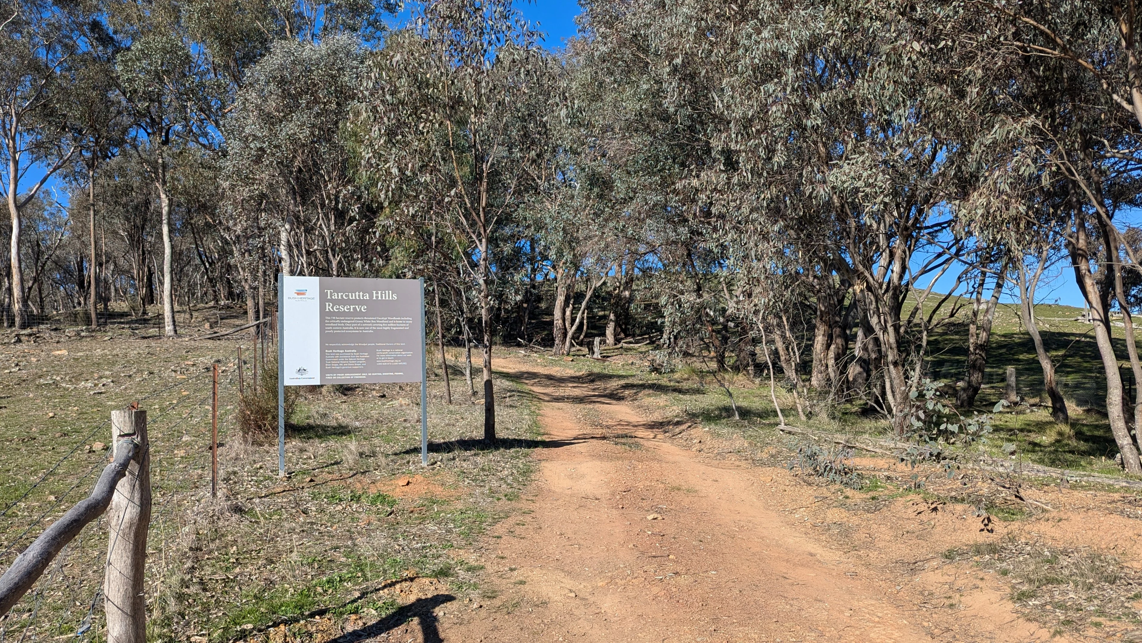
A dirt access road leads into a woodland area at Tarcutta Hills Reserve, with an information sign on the left side of the frame.
The entrance to Tarcutta Hills Reserve, featuring a gravel access road and information signage.

Tarcutta Hills Reserve history and protected-area timeline

Tarcutta Hills Reserve was acquired by Bush Heritage Australia in 1999, marking the establishment of the reserve as a dedicated conservation property. Bush Heritage, an Australian nonprofit that buys and manages land of high natural value, has continued to oversee the site through ongoing ecological management and habitat restoration.

A significant milestone came in late 2020, when Bush Heritage purchased a 288-hectare parcel adjoining the northern boundary of the original reserve. This expansion was motivated by the parcel's ecological character: it contains a large and healthy example of white box-yellow box-Blakely's red gum grassy woodland, an ecological community classified as critically endangered in New South Wales. The addition increased the reserve's total area and strengthened its role as the most extensive protection of intact grassy white box woodland in the country.

The reserve is also listed on the Register of the National Estate, recognising its heritage and conservation values at a national level, and is included within the South-west Slopes of NSW Important Bird Area identified by BirdLife International.

Tarcutta Hills Reserve landscape and geographic character

The reserve occupies the lower western slopes of the Great Dividing Range, where the tablelands gradually descend toward the inland river plains. This transitional country is characterised by gently undulating terrain with valley systems, low ridges, and scattered drainage lines. Elevation changes across the property are typical of the South West Slopes rather than the high peaks of the range further east, giving the landscape a softer, more rolling character that still retains the woodland cover that historically defined the region.

The soils and topography of the western slopes have long supported eucalypt woodlands with grassy understoreys. At Tarcutta Hills this translates into valleys and lower slopes clothed in white box, with interspersed yellow box and Blakely's red gum, particularly in the added northern parcel. The persistent tree cover, combined with the absence of large-scale clearing on the property, gives the landscape a continuous wooded appearance unusually intact for the region.

Tarcutta Hills Reserve ecosystems, habitats, and plant life

Tarcutta Hills Reserve is defined ecologically by its grassy eucalypt woodlands. The dominant formation is white box woodland with a native grass and herb understorey, a community that has been extensively reduced elsewhere in southeastern Australia due to clearing and grazing pressure. The original reserve contains the largest intact example of this woodland type in the country, and the 2020 addition contributed a high-quality stand of white box-yellow box-Blakely's red gum grassy woodland, classified as critically endangered in New South Wales.

Beneath the canopy, the understorey supports a diverse mix of native grasses, herbs, and shrubs. Recorded plant species include white cypress pine in mixed woodland patches, small-leaf bush pea, honeypot, many-flowered mat-rush, and kurrajong, suggesting a varied mosaic of microhabitats across the property. This vegetation structure offers nectar resources, hollow-bearing stem:trees for arboreal species, and a continuous grassy layer favoured by ground-foraging animals, producing the high species richness for which the reserve is noted.

Tarcutta Hills Reserve wildlife and species highlights

The reserve's wildlife values centre on its woodland-dependent birds and the habitat structure that supports them. Tarcutta Hills is part of the South-west Slopes of NSW Important Bird Area, recognised by BirdLife International because of the site's importance for swift parrots and superb parrots, two migratory and range-restricted species whose woodland habitats have been substantially reduced.

The reserve also provides habitat for additional threatened and notable bird species, including the turquoise parrot, a small parrot associated with wooded country and box-eucalypt landscapes, and the regent honeyeater, a critically endangered species tied to flowering eucalypts and box-stringybark woodland. Beyond birds, the intact woodland mosaic and grassy understorey support typical western-slope fauna, including a range of small woodland mammals, reptiles, and invertebrates associated with mature box woodland remnants.

Tarcutta Hills Reserve conservation status and protection priorities

Tarcutta Hills Reserve plays an outsized role in conservation relative to its size because it protects vegetation communities that have been heavily cleared across their former range. The grassy white box woodland it safeguards is the largest intact example of its type in Australia, and the addition of the 2020 parcel extended protection to a critically endangered ecological community listed under New South Wales conservation legislation.

The reserve's inclusion in the South-west Slopes of NSW Important Bird Area reflects its recognised value for migratory and range-restricted woodland birds, particularly swift parrots and superb parrots. As a Bush Heritage Australia property managed for biodiversity outcomes, it is subject to active conservation management, including protection from further clearing, control of threats to woodland integrity, and ongoing habitat improvement. The reserve's listing on the Register of the National Estate further underscores its national significance as a representative stand of temperate eucalypt woodland.

Top sights and standout views in Tarcutta Hills Reserve

Tarcutta Hills Reserve protects the largest intact area of grassy white box woodland in Australia, a stand that has become nationally significant because comparable vegetation has been largely cleared elsewhere. Its 2020 expansion added high-quality white box-yellow box-Blakely's red gum grassy woodland, a community classified as critically endangered in New South Wales.

The reserve forms part of the South-west Slopes of NSW Important Bird Area and supports swift parrots, superb parrots, turquoise parrots, and regent honeyeaters among its woodland-dependent fauna. Owned and managed by Bush Heritage Australia since 1999, it functions both as a refuge for threatened species and as a reference site for grassy eucalypt woodland conservation in southeastern Australia.

Best time to visit Tarcutta Hills Reserve

Tarcutta Hills Reserve is most evocative in spring and early summer, when warming temperatures bring out native wildflowers in the grassy understorey and increase activity among woodland birds, including migratory parrots. Cooler months offer quieter conditions and clearer views through the relatively open woodland canopy, while summer can be hot and dry across the western slopes. Visitors should treat the reserve primarily as a conservation property rather than a fully equipped visitor destination.

Monthly climate preview

Long term monthly temperature and precipitation patterns from representative coordinates

Tarcutta Hills Reserve Climate Normals and Annual Temperature Rhythm

Tarcutta Hills Reserve experiences a measured annual temperature and precipitation rhythm across twelve recorded months. Examining the complete climate normals profile provides deeper analytical insight into long term monthly variations.
Annual mean15 °C
7 °C24 °C
Jan24°
Feb23°
Mar20°
Apr15°
May11°
Jun
Jul
Aug
Sep10°
Oct14°
Nov18°
Dec21°
Warmest month
January

24.3 °C

Coolest month
July

6.6 °C

Wettest month
June

2.4 mm/day

Driest month
April

1.4 mm/day

Park location guide

Geography guide, regional context, and park location map for Tarcutta Hills Reserve

Tarcutta Hills Reserve park geography, regions, and map view in Australia

Understand where Tarcutta Hills Reserve sits in Australia through a broader geographic reading of the surrounding landscape, nearby location context, and its mapped position within the national park landscape.

How Tarcutta Hills Reserve fits into Australia

Australia is a constitutional monarchy and federal parliamentary democracy comprising six states and ten territories. With a population of nearly 28 million, it is one of the world's most urbanised countries, with most people concentrated on the eastern seaboard. The country has a high Human Development Index and is known for its cultural diversity, ancient Aboriginal heritage, and unique wildlife.

Wider geography shaping Tarcutta Hills Reserve in Australia

Australia occupies the entire Australian continent, the island of Tasmania, and numerous smaller islands. It is the world's flattest and driest inhabited continent, featuring vast deserts in the interior (the Outback), tropical rainforests along the eastern coast, and a coastline bordering the Indian and Pacific Oceans.

Map view of Tarcutta Hills Reserve

Use this park location map to pinpoint Tarcutta Hills Reserve in Australia, understand its exact geographic position, and read its mapped placement within the surrounding landscape more clearly.

Pigeon | © OpenStreetMap contributors

Location context for Tarcutta Hills Reserve

New South Wales
Recorded earthquake history

Explore the Historical Earthquake Catalogue for Tarcutta Hills Reserve

Review recorded seismic activity associated with the geography of Tarcutta Hills Reserve. This MoriAtlas catalogue provides structured access to historical earthquake data, allowing researchers to examine documented epicentres and their proximity to this protected woodland area.

Tarcutta Hills Reserve Earthquake History

Catalogued events

1 event

Strongest magnitude

Magnitude 3.9

Most recent event

Feb 28, 2004

This history includes earthquakes recorded inside the park or within 50 km of its borders

Explore detailed imagery of eucalypt terrain, grassy understoreys, and natural habitats.

Tarcutta Hills Reserve Photos and Landscapes: Visualizing the Woodland Protected Area

Visual documentation captures the undulating terrain, white box woodlands, and native eucalypt habitats defining the reserve across the western slopes. Photographic records provide clear visual context for understanding the protected landscape structure and ecological value of the region.

A dirt access road leads into a woodland area at Tarcutta Hills Reserve, with an information sign on the left side of the frame.

Park atlas

Compare regional conservation areas and woodland habitats across the western slopes of New South Wales

Other Parks Near Tarcutta Hills Reserve and Surrounding Protected Landscapes

Browse nearby national parks and protected areas located along the western slopes of the Great Dividing Range to expand your regional geographic comparison. Examining adjacent woodland reserves and conservation properties provides a broader perspective on the ecological corridors of southeastern Australia.
National parkNew South Wales
About 28 km away#1 closest

West

Livingstone National Park: National Park Protected Landscape and Geographic Context

Mapped terrain and protected area discovery for this New South Wales park.

Investigate Livingstone National Park as a key protected natural area in New South Wales. This detail entry offers insights into its mapped boundaries, regional geographic setting, and landscape character. Explore how this national park contributes to the broader atlas of Australian protected lands and understand its distinct natural terrain through detailed geographic data.

Area
19.19 km²
Established
2001
IUCN
II
Relief
Mixed relief
Watercolor painting depicting a panoramic view of rolling hills with scattered trees and soft, warm-toned washes of green and pink against a white background.
Nature reserveNew South Wales
About 33 km away#2 closest

Southwest

Nest Hill Nature Reserve: Geographic Overview and Protected Woodland Mapping

Inland New South Wales temperate woodland conservation and landscape analysis

Located between Holbrook and Wagga Wagga, Nest Hill Nature Reserve preserves a significant tract of dry eucalypt woodland. The area features broad ridges and gentle slopes that reflect the transitional landscape of the South Western Slopes. This protected site remains a key reference point for understanding woodland biodiversity recovery and the long term stewardship of former timber harvesting lands in Australia.

Area
7.59 km²
Established
2001
IUCN
Ia
Relief
Upland
Watercolor painting showing mountains, fields, and a river
National parkNew South Wales
49 km away#3 closest

Southeast

Kosciuszko National Park: Australia's Highest Alpine Terrain and Mapped Protected Landscape

Discover unique glacial landscapes and geographic context in New South Wales.

Kosciuszko National Park represents the pinnacle of Australia's alpine geography, preserving the continent's only true alpine ecosystems. This extensive national park in New South Wales features dramatic glacial landforms, including its namesake Mount Kosciuszko, Australia's highest peak. Users can explore the park's mapped boundaries, surrounding natural terrain, and unique landscape features for a comprehensive understanding of this significant protected area.

Area
6,900 km²
Established
1944
IUCN
II
Visitors
3.3M annual
National parkNew South Wales
About 57 km away#4 closest

South

Woomargama National Park: National Park Protected Area with Mapped Landscape Identity

Discover the geographic context and park boundaries.

Woomargama National Park serves as a distinct entity for geographic exploration within New South Wales. As a designated national park, its protected landscape identity is integral to understanding the regional map. This profile facilitates detailed study of its position, natural terrain context, and role within Australia's network of conservation areas, providing structured data for atlas-based discovery.

Area
241.85 km²
Established
2001
IUCN
II
Relief
Upland
Nature reserveNew South Wales
About 61 km away#5 closest

North

Ulandra Nature Reserve: Atlas Overview, Mapped Terrain, and Regional Protected Landscapes

Woodland conservation in the New South Wales Riverina fringe

Ulandra Nature Reserve serves as a vital sanctuary for the Cootamundra wattle and native woodland communities within a highly modified agricultural landscape. The reserve protects the rugged slopes of the Ulandra Range and the catchment of Merrybundinah Creek, offering a clear window into the natural forest geography of southeastern Australia.

Area
39.3 km²
Established
1981
IUCN
Ia
Relief
Upland
National parkNew South Wales
67 km away#6 closest

Southwest

Benambra National Park: New South Wales Protected Area and Great Yambla Range Map

Explore mapped terrain and woodland ecosystems.

Benambra National Park serves as a key protected area in New South Wales, preserving crucial white box and Red Box woodland communities against a backdrop of the Great Yambla Range's dramatic topography. This national park is significant for its role in conserving habitat for at least twelve threatened bird species and its unique geological features, including cliff faces and flat-topped peaks. Understanding the park's mapped boundaries and its place within the South West Slopes region offers valuable context for geographic discovery and the study of Australia's natural landscapes.

Area
13.99 km²
Established
2001
IUCN
II
Relief
Mixed relief
National parkAustralia
67 km away#7 closest

South

Burrowa-Pine Mountain National Park: Australia's Iconic Granite Monolith and Mountain Wilderness

Explore its mapped boundaries and unique regional geography.

Burrowa-Pine Mountain National Park stands as a prominent protected wilderness in Victoria, Australia, renowned for its spectacular geological features. The park is dominated by the colossal Pine Mountain, a massive sandstone monolith that commands the landscape, and the elevated Mount Burrowa, offering expansive vistas across the Victorian Alps. Its mountainous terrain, characterized by rocky ridgelines and alpine forests, makes it a distinctive destination for understanding Australia's natural and geographic heritage. Discover the mapped extent and landscape character of this important national park.

Area
184 km²
Established
1978
IUCN
II
Relief
Mountain
Nature reserveNew South Wales
About 87 km away#8 closest

West

Wiesners Swamp Nature Reserve: Mapping the Floodplain Landscapes of New South Wales

A preserved ephemeral wetland and woodland habitat

Wiesners Swamp Nature Reserve represents a critical protected wetland basin in the South Western Slopes of New South Wales. The reserve provides a mapped view of seasonal floodplain dynamics, including river red gum woodland and woodland patches on higher ground that support local waterbirds and native mammals.

Area
1.03 km²
Established
1996
IUCN
Ia
Relief
Lowland

Common questions about visiting, size, designation, and location context for Tarcutta Hills Reserve

Tarcutta Hills Reserve FAQs for park facts, access, geography, and protected area context

Find quick answers about Tarcutta Hills Reserve, including protected-area facts, park geography, trail and visitor context, and how the park fits into its surrounding country and regional landscape.
MoriAtlas Explorer

Continue Your Protected Areas Search Across the Global Atlas

Deepen your exploration by continuing the structured search for national parks and protected areas worldwide. Utilize the comprehensive filtering capabilities to compare different conservation landscapes and refine your understanding of global park geography. Discover more about the distribution and characteristics of protected natural areas.

Global natural geography
