

Mori Atlas logo
Protected landscapeTarnobrzeska Dolina Wisły

A vital ecological corridor featuring riparian forests, active river channels, and rare floodplain habitats.

Tarnobrzeska Dolina Wisły Protected Landscape: Mapped Geography and Vistula River Floodplain Context

Spanning 45 kilometers of the middle Vistula river valley, Tarnobrzeska Dolina Wisły serves as a primary protected landscape connecting the Świętokrzyskie and Podkarpackie regions. This lowland corridor hosts a mosaic of alluvial riparian forests, oxbow lakes, and wet meadows shaped by constant river dynamics. The geography defines a transition zone between the broad floodplain and the historic hill ranges near Sandomierz, providing a sanctuary for diverse river-dependent species and complex fluvial habitat systems.

river floodplainVistula valleyNatura 2000 sitespecial area of conservationfloodplain forestoxbow lakes
A flat-style digital illustration depicting a wide river winding through a valley with cliffs on the right, trees in the foreground, and a bridge crossing the water in the distance.

Tarnobrzeska Dolina Wisły

Protected landscape

Park overview

Structured park overview, official facts, and landscape profile for Tarnobrzeska Dolina Wisły

Tarnobrzeska Dolina Wisły park facts, protected area profile, and essential visitor context

Review the core facts for Tarnobrzeska Dolina Wisły, including designation, size, terrain, visitor scale, habitats, and operating context in one park-focused overview.

About Tarnobrzeska Dolina Wisły

Tarnobrzeska Dolina Wisły is one of the more substantial Natura 2000 habitat sites along Poland's middle Vistula, designated to protect an unusually long and continuous riverine landscape rather than a compact core zone. Its roughly 45-kilometre extent links two well-known geographic anchors: the confluence of the Wisłoka at Gawłuszowice in the south and the historic town of Sandomierz in the north, where the river valley meets the distinctive Góry Pieprzowe hills. This linear geography is central to the site's ecological value, because it keeps floodplain habitats connected across a meaningful stretch of river.

The area belongs to the Nizina Nadwiślańska mesoregion, the lowland macro-landscape that defines the middle course of the Vistula. Across about 4,060 hectares, the site combines elements typical of a large lowland river system: the main river channel, backwaters and oxbow lakes, soft alluvial islands, periodically flooded meadows, marshy communities along the banks, and substantial areas of łęgi, the characteristic willow-poplar-alder floodplain forests of Central European rivers. Together, these features make the protected area a representative refuge for habitats that have been heavily modified or lost elsewhere in Poland's river systems.

Within Poland's Natura 2000 framework, the site is categorized as a special area of conservation for habitat types, meaning that its designation focuses specifically on the natural habitats listed in Annex I of the EU Habitats Directive. Seven such habitat types are documented within its boundaries, ranging from aquatic communities of the Ranunculion fluitantis alliance and starorzecza oxbow habitats to herb-rich nadrzeczne ziołorośla, selernicowe meadows, fresh meadows, and łęgi floodplain forests. This habitat diversity, compressed into a narrow valley corridor, gives the area an outsized conservation significance relative to its size.

Beyond its strictly ecological role, Tarnobrzeska Dolina Wisły is also integrated into the regional cultural and educational landscape of the Vistula valley. Its administrative territory spans multiple counties and includes the city of Tarnobrzeg, while Sandomierz serves as a natural northern anchor point. The Regional Promotion Centre for the Tarnobrzeska Dolina Wisły Natura 2000 area, located in the historical outbuildings of the Tarnowski family estate near the Dzików Palace in Tarnobrzeg, gives the protected area a visible on-the-ground presence that links nature protection with the cultural heritage of the broader Vistula valley region.

Quick facts and research context for Tarnobrzeska Dolina Wisły

Tarnobrzeska Dolina Wisły is a special area of conservation within the European Natura 2000 network, identified by the code PLH180049. It was formally designated in 2011 and spans roughly 4,059.69 hectares along a 45-kilometre section of the Vistula river in southeastern Poland.

The site lies at the boundary of the Świętokrzyskie and Podkarpackie voivodeships, covering parts of Staszów and Sandomierz counties to the north and Mielec, Tarnobrzeg, and the city of Tarnobrzeg to the south. It belongs to the Nizina Nadwiślańska mesoregion, the broad lowland belt that follows the middle Vistula, and includes seven natural habitat types listed under Annex I of the EU Habitats Directive and several Annex II animal species.

Protection and recognition

Documented terrestrial protected area status and official Natura 2000 listings

Tarnobrzeska Dolina Wisły Protection Status and Conservation Recognition

Tarnobrzeska Dolina Wisły preserves terrestrial protected area status through verified Natura 2000 designations. Official records outline the conservation scope and recognized ecological boundaries for this location.
Park context

Deeper park guide and search-rich context for Tarnobrzeska Dolina Wisły

Tarnobrzeska Dolina Wisły history, landscape, wildlife, and travel context

Explore Tarnobrzeska Dolina Wisły through its history, landscape character, ecosystems, wildlife, conservation priorities, cultural context, and seasonal travel timing in a structured park guide built for atlas discovery and search intent.

Why Tarnobrzeska Dolina Wisły stands out

Tarnobrzeska Dolina Wisły is best known as a Vistula floodplain sanctuary: a long, continuous corridor of riverine habitats where riverine forests, oxbows, wet meadows, and actively shifting riverbanks come together in one of the better preserved sections of the middle Vistula valley. The area is especially valued for its concentration of habitats from Annex I of the EU Habitats Directive, including starorzecza, Ranunculion fluitantis aquatic plant communities, riverbank herb communities, nadrzeczne ziołorośla, selernicowe meadows, fresh meadows, and characteristic łęgi floodplain forests. Equally, it is known for the species-rich communities that depend on these habitats. Annex II species recorded here include the European beaver, Eurasian otter, the large copper butterfly Lycaena dispar, the dusky large blue Phengaris nausithous, the fire-bellied toad Bombina bombina, the bitterling Rhodeus sericeus amarus, the asp Leuciscus aspius, and the white-finned gudgeon Gobio albipinnatus, together giving the site a strong reputation as a hotspot for riverine biodiversity conservation in southeastern Poland.
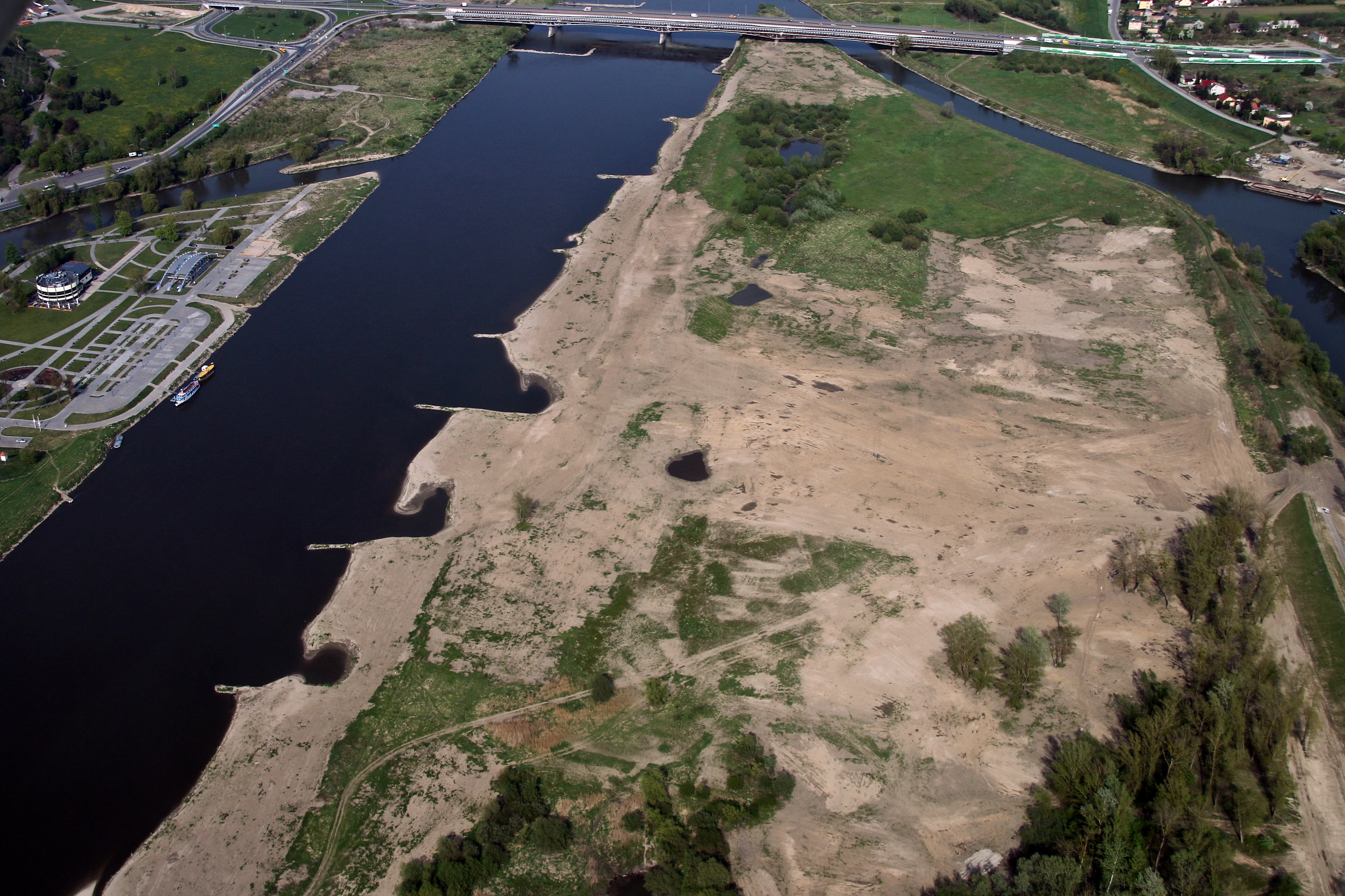
An aerial view of the Vistula River with a sandy shoreline, riverbanks, and a distant bridge.
Aerial view of the Vistula River valley within the Tarnobrzeska Dolina Wisły protected area.

Tarnobrzeska Dolina Wisły history and protected-area timeline

Tarnobrzeska Dolina Wisły was formally established in 2011 as a special area of conservation within Poland's Natura 2000 network, under the code PLH180049. Its designation fits into the wider expansion of the Natura 2000 system across Poland in the early 2010s, when many riverine and lowland sites were added to the EU's ecological network to complete national coverage of priority habitat types.

The documentation of the area, including inventories of its Annex I habitats and Annex II species, was consolidated in regional publications such as Majkut A. 2012, 'Tarnobrzeska Dolina Wisły', included in the volume 'Obszary Natura 2000 na Podkarpaciu' edited by Rogała and Marcela and published by the Regional Directorate for Environmental Protection in Rzeszów. This regional-level publication effort helped anchor the site in the conservation framework of the Podkarpackie region and supported the establishment of the Regional Promotion Centre housed in the historic Tarnowski estate buildings near the Dzików Palace in Tarnobrzeg, which became a focal point for public engagement with the site's ecological values.

Tarnobrzeska Dolina Wisły landscape and geographic character

The protected area is defined by the broad, lowland valley of the middle Vistula, a flat alluvial corridor shaped by centuries of river dynamics. Across its 45-kilometre length, the terrain alternates between the active river channel, soft alluvial bars and islands, periodically flooded grasslands, and higher older alluvial terraces. Around a quarter of the site is covered by łęgi, the typical willow, poplar, and alder floodplain forests that line Central European lowland rivers.

At its northern end, near Sandomierz, the valley meets the Góry Pieprzowe, a distinctive low hill range that provides a sharp geological contrast to the flat floodplain. This transition between alluvial valley and upland edge is one of the defining landscape features of the area, marking the boundary where the riverine system of the Vistula meets older geological formations. Across most of the rest of the site, however, the landscape remains a lowland mosaic: water, reedbeds, meadows, riparian thickets, and floodplain forest in a shifting, water-shaped pattern.

Tarnobrzeska Dolina Wisły ecosystems, habitats, and plant life

Ecologically, Tarnobrzeska Dolina Wisły represents a concentrated example of the habitat mosaic found along the middle Vistula. The site harbours seven Annex I habitat types: starorzecza oxbow lakes, aquatic plant communities of the Ranunculion fluitantis alliance, flooded and muddy riverbanks, nadrzeczne ziołorośla riparian herb communities, selernicowe meadows, fresh meadows, and łęgi floodplain forests.

These habitats form a tightly connected ecological gradient from open water through wet meadows and reedbeds to closed-canopy floodplain woodland. Such gradients are increasingly rare in heavily modified European river systems, and their preservation here is one of the site's primary conservation functions. The presence of both still-water habitats (oxbows, flooded margins) and flowing-water habitats helps maintain habitat diversity for very different ecological groups within a relatively narrow spatial envelope.

Tarnobrzeska Dolina Wisły wildlife and species highlights

The site's wildlife profile reflects its riverine landscape and supports a range of species that benefit from intact floodplain habitat complexes. Mammals documented under Annex II of the Habitats Directive include the European beaver Castor fiber, whose presence is often associated with active modification of shorelines and backwaters, and the Eurasian otter Lutra lutra, typically linked to clean, fish-rich water systems.

Among invertebrates, the site hosts butterflies of conservation interest, including the large copper Lycaena dispar and the dusky large blue Phengaris nausithous, both of which depend on specific host plants and meadow management regimes. In the water column, fish species of conservation concern include the asp Aspius aspius, the white-finned gudgeon Gobio albipinnatus, and the bitterling Rhodeus sericeus amarus, all of which depend on connectivity and habitat quality within the river system. On the land-water interface, the fire-bellied toad Bombina bombina contributes to the site's strong amphibian profile. Together, these species underline the importance of the area for protecting river-dependent fauna in southeastern Poland.

Tarnobrzeska Dolina Wisły conservation status and protection priorities

From a conservation perspective, Tarnobrzeska Dolina Wisły matters primarily as a representative, well-connected refuge for habitats of the middle Vistula that have been heavily degraded elsewhere in Poland and across Central Europe. The site's 45-kilometre linear extent preserves habitat continuity along the floodplain, which is critical for many riverine species that require connectivity between aquatic, semi-aquatic, and terrestrial habitats.

Its designation under the Habitats Directive (rather than the Birds Directive) emphasizes the priority of habitat types and protected animal species linked to those habitats. Łęgi floodplain forests, selernicowe and fresh meadows, and rare riverbank habitats such as Ranunculion fluitantis communities and nadrzeczne ziołorośla are among the habitat types for which Polish Natura 2000 coverage is otherwise limited, making this site an important component of national-level conservation networks for these habitat types. The integration of the Natura 2000 promotion centre in Tarnobrzeg further strengthens the site's role in public conservation education.

Tarnobrzeska Dolina Wisły cultural meaning and human context

The protected area is closely tied to the cultural landscape of the middle Vistula valley. Sandomierz, at its northern edge, is one of Poland's most important historic towns, while Tarnobrzeg, within the administrative extent of the site, hosts the 17th-century Dzików Palace associated with the Tarnowski family. The Natura 2000 Regional Promotion Centre for the area is housed in the historical outbuildings of this same estate, creating a direct link between natural-heritage conservation and the architectural heritage of the regional nobility.

Rural settlements along the valley, including the villages and small towns of Staszów, Sandomierz, Mielec, Gawłuszowice, and surrounding districts, have long defined land use in the floodplain, including hay meadow management, traditional grazing, and small-scale river use. These patterns continue to shape the ecological character of the protected habitats, particularly the meadows and herb-rich communities that depend on traditional management regimes.

Top sights and standout views in Tarnobrzeska Dolina Wisły

Tarnobrzeska Dolina Wisły is notable for combining unusually long habitat continuity with a high concentration of Annex I habitat types within a single Natura 2000 site, making it a key reference area for the middle Vistula floodplain. Approximately 25 percent of its area is covered by łęgi floodplain forests, supporting species that need large, connected riverine woodland systems.

The site's accessibility from two important regional centres, Sandomierz and Tarnobrzeg, and the presence of an on-site Natura 2000 promotion centre in the historic Tarnowski estate near the Dzików Palace make it an unusually approachable protected area, with both ecological and cultural heritage values concentrated along a single 45-kilometre stretch of the Vistula.

Best time to visit Tarnobrzeska Dolina Wisły

The Tarnobrzeska Dolina Dolina Wisły landscape changes significantly with the seasons, largely because of the central role of water and floodplain meadows. Late spring and early summer are typically the most active period for meadow habitats, when selernicowe and fresh meadows, as well as nadrzeczne ziołorośla, come into flower and support the highest diversity of butterflies and other pollinators, including the protected Lycaena dispar and Phengaris nausithous.

Autumn offers a quieter but visually rich period, when floodplain forests display seasonal colour and river levels often stabilize after summer lows, improving chances of observing beaver and otter activity along the banks and oxbows. Winter visits highlight the open structure of the floodplain and the contrast between the river corridor and the Góry Pieprzowe near Sandomierz, though many meadow habitats are then dormant. As with any riverine lowland site, seasonal water levels can strongly affect accessibility of specific backwaters and meadows.


Monthly climate preview

Long-term temperature and precipitation records across representative coordinates

Tarnobrzeska Dolina Wisły Climate Normals and Monthly Weather Statistics

Tarnobrzeska Dolina Wisły records measured monthly temperature variations alongside steady precipitation patterns spanning multiple years of recorded climatology data. Reviewing the comprehensive twelve-month profile provides deeper context on long-term thermal rhythms and precipitation averages.
Annual mean9 °C
-4 °C21 °C
Jan-4°
Feb-2°
Mar
Apr
May15°
Jun19°
Jul21°
Aug20°
Sep15°
Oct
Nov
Dec-2°
Warmest month
July

20.8 °C

Coolest month
January

-3.6 °C

Wettest month
July

2.8 mm/day

Driest month
January

1.2 mm/day

Park location guide

Geography guide, regional context, and park location map for Tarnobrzeska Dolina Wisły

Tarnobrzeska Dolina Wisły park geography, regions, and map view in Poland

Understand where Tarnobrzeska Dolina Wisły sits in Poland through a broader geographic reading of the surrounding landscape, nearby location context, and its mapped position within the national park landscape.

How Tarnobrzeska Dolina Wisły fits into Poland

Poland, officially the Republic of Poland, is a Central European country spanning from the Baltic Sea in the north to the Carpathian Mountains in the south. It borders Germany, Czech Republic, Slovakia, Ukraine, Belarus, Lithuania, and Kaliningrad Oblast. The country has a temperate climate, diverse landscapes, and is known for its rich history, cultural heritage, and strong economic position within the EU.

Wider geography shaping Tarnobrzeska Dolina Wisły in Poland

Poland occupies 312,696 km2 in Central Europe, extending from the Baltic Sea coast in the north to the Sudetes and Carpathian Mountains in the south. It borders Germany to the west, Czech Republic and Slovakia to the south, Ukraine and Belarus to the east, and Lithuania and Kaliningrad Oblast to the northeast. The landscape includes lowland plains, uplands, and mountain ranges.

Map view of Tarnobrzeska Dolina Wisły

Use this park location map to pinpoint Tarnobrzeska Dolina Wisły in Poland, understand its exact geographic position, and read its mapped placement within the surrounding landscape more clearly.

Pigeon | © OpenStreetMap contributors

Location context for Tarnobrzeska Dolina Wisły

Tarnobrzeska Dolina Wisły

Explore protected riverine scenery, floodplain forests, and lowland habitats through detailed visual records.

Tarnobrzeska Dolina Wisły Photos and Landscapes: Visualizing the Vistula River Valley

Visual documentation reveals the intricate terrain of shifting riverbanks, oxbow lakes, and riparian woodlands across the protected Vistula valley corridor. Examining these habitat photographs deepens understanding of lowland floodplain ecosystems and regional conservation characteristics.

An aerial view of the Vistula River with a sandy shoreline, riverbanks, and a distant bridge.

Park atlas

Compare adjacent river valleys, regional wetlands, and connected protected habitats

Exploring Other Parks Near Tarnobrzeska Dolina Wisły and Surrounding Protected Landscapes

Compare Tarnobrzeska Dolina Wisły with other protected areas across the surrounding region to analyze adjacent river valleys and lowland reserves. Broader geographic comparison reveals how regional conservation corridors connect lowland floodplains and alluvial landscapes.
Nature reserveświętokrzyskie
1.5 km away#1 closest

West

Ostoja Żyznów Protected Landscape: Loess Ravines and River Valleys of Świętokrzyskie

A dense mosaic of xerothermic grasslands and mixed forest ecosystems

Ostoja Żyznów protects a compact yet ecologically rich region characterized by deep loess gullies and the meandering paths of the Koprzywianka and Kacanka rivers. The area creates a striking transitional landscape, shifting from flat agricultural plateaus to steep, forest-covered ravines and cliff-like river walls. This site offers significant value for understanding regional biodiversity, featuring a rare combination of warm-dry grasslands and moisture-dependent peatland habitats in the heart of Poland.

Area
44.8 km²
Established
2011
Relief
Mixed relief
Climate
Temperate
Protected areaPoland
8 km away#2 closest

East

Uroczyska Lasów Janowskich: Protected Forest and Wetland Geography in Eastern Poland

Mapping the extensive Natura 2000 lowland forest and peatland complexes

Spanning the Biłgoraj Plain and San River valley, Uroczyska Lasów Janowskich is a notable lowland forest complex in Poland. Its terrain integrates mature oak-hornbeam woods with diverse peatland systems, offering a clear look at how layered conservation strategies protect rare European habitats within a single continuous geographic block.

Area
345.443 km²
Established
2009
Relief
Lowland
Climate
Temperate
Watercolor illustration of a winding stream flowing through a green valley with rolling hills in the background and reeds in the foreground.
Nature reservePoland
About 17 km away#3 closest

South

Rezerwat przyrody Dolina Smarkatej: Protected River Landscape and Wetland Geography in Poland

Mapping fluvial corridors in the Sandomierz Forest

Rezerwat przyrody Dolina Smarkatej protects a unique stretch of free-flowing lowland river in southeastern Poland. This nature reserve sustains critical wetland ecosystems, including oxbow lakes and peat bogs, while providing a protected corridor for freshwater biodiversity within the broader Sandomierz Forest region.

Area
0.559 km²
Established
2024
Nature reserveLubelskie Voivodeship
19 km away#4 closest

Northeast

Szczecyn Nature Reserve: Mapping Protected Deciduous Forest Habitats in Eastern Poland

A vital mosaic of oak-hornbeam forest enclaves and nature reserves.

Szczecyn functions as a specialized Natura 2000 conservation landscape, spanning four forest enclaves across the border of the Lubelskie and Podkarpackie voivodeships. This site provides an essential reference for lowland deciduous forest protection, emphasizing the preservation of old-growth oak-hornbeam stands and thermophilic habitats. The area serves as a critical refuge for rare flora and invertebrates within a broader agricultural mosaic.

Area
9.325 km²
Established
2011
Relief
Upland
Climate
Temperate
Nature reserveLublin Voivodeship
About 22 km away#5 closest

Northeast

Rezerwat przyrody Doły Szczeckie: Upland Forest and Karst Landscape Geography in Lublin Voivodeship

A protected nature reserve featuring distinct ravine systems and ancient beech stands

Rezerwat przyrody Doły Szczeckie is defined by its dissected, scenic karst terrain featuring a network of dry valleys and deep gorges. Located in the Lublin Voivodeship, this nature reserve protects significant stands of European beech and hornbeam that anchor the region's broader broadleaf forest identity. Use this data to understand the elevation shifts and boundaries that shape this distinct patch of protected Polish landscape.

Area
2.036 km²
Established
1997
Relief
Upland
Scope
Terrestrial
Nature reserveLublin Voivodeship
About 27 km away#6 closest

Northeast

Rezerwat przyrody Marynopole: Mapping the Upland Forest Landscapes of Lublin Voivodeship

Protected silver fir and oak stands in the Wzniesienia Urzędowskie hills

Rezerwat przyrody Marynopole acts as a critical conservation site for silver fir and mature oak forest within the Lublin Voivodeship of southeastern Poland. This nature reserve offers deep insight into upland ecology, protecting old-growth stands that thrive across the rolling, loamy terrain of the Wzniesienia Urzędowskie mesoregion.

Area
1.57 km²
Established
1976
Relief
Upland
Scope
Terrestrial
A horizontal watercolor painting showing a stylized landscape with rolling green hills, a forest of trees, and distant purple-hued mountains under a soft light.
Nature reservePodkarpackie Voivodeship
About 28 km away#7 closest

South

Rezerwat przyrody Bagno Przecławskie: Mapped Peatland and Protected Forest Geography

Protected wetland landscapes in Podkarpackie Voivodeship

Examine the geographic profile of Rezerwat przyrody Bagno Przecławskie, a significant nature reserve in the Sandomierz Basin. This protected area features open peatland, floating bog mats, and forest transition zones, providing a clear window into the ecological history and lowland wetland terrain of this unique Polish region.

Area
0.256 km²
Established
1979
Relief
Lowland
Climate
Temperate
Protected landscapeŚwiętokrzyskie Voivodeship
35 km away#8 closest

West

Szaniecki Park Krajobrazowy: Protected Landscape Atlas and Regional Map Context

Exploring xerothermic habitats across the Ponidzie plateau

Szaniecki Park Krajobrazowy anchors conservation efforts across the Płaskowyż Szaniecki and the Garb Pińczowski ridge. This detailed profile tracks the regional geography, calcareous soil influence, and the protection of rare steppe flora within the broader Świętokrzyskie Voivodeship landscape framework.

Area
112.896 km²
Established
1986
Relief
Upland
Climate
Temperate

Common questions about visiting, size, designation, and location context for Tarnobrzeska Dolina Wisły

Tarnobrzeska Dolina Wisły FAQs for park facts, access, geography, and protected area context

Find quick answers about Tarnobrzeska Dolina Wisły, including protected-area facts, park geography, trail and visitor context, and how the park fits into its surrounding country and regional landscape.
MoriAtlas Explorer

Continue Your Protected Areas Search Across the Global Atlas

Deepen your exploration by continuing the structured search for national parks and protected areas worldwide. Utilize the comprehensive filtering capabilities to compare different conservation landscapes and refine your understanding of global park geography. Discover more about the distribution and characteristics of protected natural areas.

Global natural geography