Mori Atlas logo
Biosphere reserveTaujėnų–Užulėnio miškų biosferos poligonas

Mapping the extensive forest mosaics, peatland hydrology, and lowland conservation landscapes

Taujėnų–Užulėnio miškų biosferos poligonas: A Core Forest Protected Area in Central Lithuania

(Taujeиnaи–Užeиleиnio miиеkuий biosferos poligonas)

Taujėnų–Užulėnio miškų biosferos poligonas serves as a pivotal biosphere reserve in central Lithuania, protecting over 22,500 hectares of contiguous forest territory. This expansive landscape integrates mature deciduous, mixed, and coniferous stands with vital peatland ecosystems, functioning as a primary habitat for rare avian species and diverse forest wildlife. The area exemplifies a distinct conservation-focused forest management model, preserving natural hydrology and deadwood structures across the Baltic lowland plains.

biosphere polygonlowland forestbroadleaf forestmixed forestpeatlandNatura 2000

Taujėnų–Užulėnio miškų biosferos poligonas

Biosphere reserve

Park overview

Structured park overview, official facts, and landscape profile for Taujeиnaи, Užeиleиnio Forest Biosphere Polygon

Taujeиnaи, Užeиleиnio Forest Biosphere Polygon park facts, protected area profile, and essential visitor context

Review the core facts for Taujeиnaи, Užeиleиnio Forest Biosphere Polygon, including designation, size, terrain, visitor scale, habitats, and operating context in one park-focused overview.

About Taujeиnaи, Užeиleиnio Forest Biosphere Polygon

The Taujeиnaи–Užeиleиnio Forest Biosphere Polygon sits in the transitional zone between three Lithuanian districts: Ukmerge, Anykšiai, and Panevezys. Although the polygon is often described together with the Ukmerge district, its actual boundaries extend into neighboring administrative areas as well, creating a landscape-level protected territory that is far larger than a typical small reserve. With more than 22 500 hectares it belongs to a category of large forest biosphere polygons rather than compact national parks or small reserves, and its scale is one of the defining features of its identity.

The territory is overwhelmingly forested. Broadleaf forest covers roughly a third of the polygon, mixed forest forms another quarter, and coniferous plus transitional-stage forest and shrubland account for further significant shares. Around a quarter of the polygon consists of arable fields adjacent to the forest blocks, and meadows and pastures provide additional open habitats that are critical feeding and insect-breeding grounds for the protected bird species. Smaller portions of the territory are made up of water bodies, peatlands, and mires, including the small but ecologically valuable Barnenai telmological reserve.

The polygon is part of Lithuania's contribution to the European Natura 2000 ecological network and was added to the list of bird protection areas in order to maintain viable breeding populations of several rare, demanding forest species. Conservation targets within the polygon include minimum numbers of breeding pairs, and management is explicitly geared toward keeping the forest in a state that supports those populations over the long term.

Because the polygon is closely tied to the broader Anykšiai Regional Park system through its monitoring activities, it functions as both a working forest and a scientific reference area. Forestry work continues within its boundaries, but it is regulated by stricter rules than in ordinary Lithuanian forests, and the territory is more frequently visited by researchers, forestry specialists, and training groups than by casual tourists.

Quick facts and research context for Taujeиnaи, Užeиleиnio Forest Biosphere Polygon

Location: central Lithuania, spanning Ukmerge, Anykšiai, and Panevezys districts, about 20 km northwest of Ukmerge. Protection profile: established in 2004 as a biosphere polygon, part of the Natura 2000 network through the Birds Directive site list. Land cover: broadleaf forest, mixed forest, and coniferous or transitional forest stages dominate, with agricultural land, meadows, pastures, peatlands, and water bodies making up the remainder. Management: forestry handled by Ukmerge and Panevezys forest enterprises, while Anykšiai Regional Park staff lead species monitoring and scientific surveys.

Protection and recognition

Explore documented terrestrial protection metrics and management scope.

Taujėnų–Užulėnio miškų biosferos poligonas Protection Status and Recognition

Taujėnų–Užulėnio miškų biosferos poligonas maintains a documented terrestrial protection status within the regional reserve network. Fact-checking records compile official designation history, management scope, and verified international recognition sources where applicable.

Protection details

Protection scope
Terrestrial
Transboundary protection
No
Park context

Deeper park guide and search-rich context for Taujeиnaи, Užeиleиnio Forest Biosphere Polygon

Taujeиnaи, Užeиleиnio Forest Biosphere Polygon history, landscape, wildlife, and travel context

Explore Taujeиnaи, Užeиleиnio Forest Biosphere Polygon through its history, landscape character, ecosystems, wildlife, conservation priorities, cultural context, and seasonal travel timing in a structured park guide built for atlas discovery and search intent.

Why Taujeиnaи, Užeиleиnio Forest Biosphere Polygon stands out

The polygon is best known as one of Lithuania's most important breeding sites for the black stork and the lesser spotted eagle, both of which require large, quiet, mature forest territories with intact hydrology. It is also recognized at the European level for its concentrations of three rare woodpecker species, including the grey-headed, middle spotted, and white-backed woodpecker, which together signal a notably high-quality deciduous and mixed forest landscape. The combination of strong deadwood retention, breeding-season logging restrictions, and dedicated species monitoring makes it a reference site for lowland forest conservation in the Baltic region.
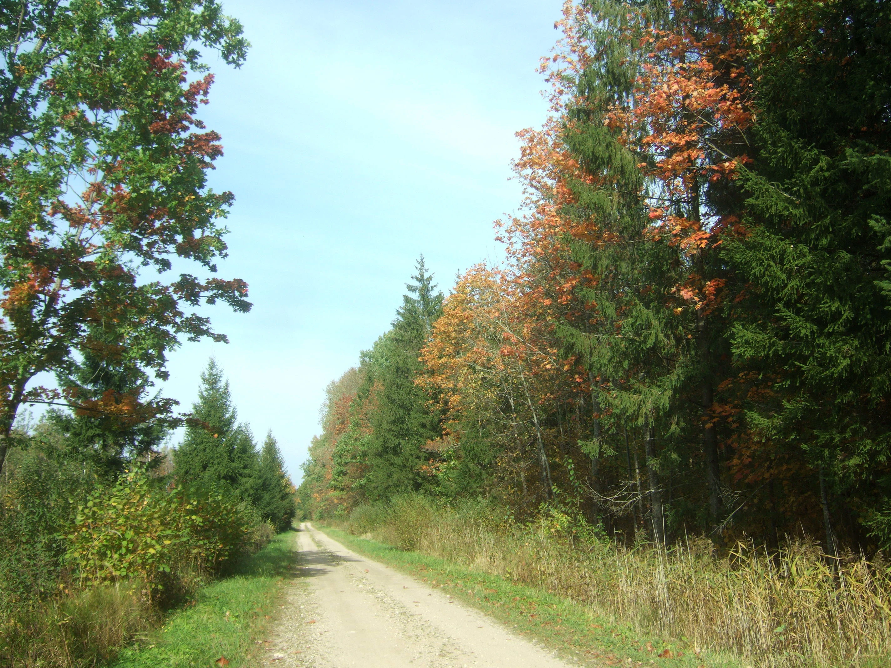
A narrow dirt road stretches into the distance, flanked by deciduous and coniferous trees showing early autumn foliage.
A dirt forest track winding through the mixed woodlands of Taujenai-Uzulenis Biosphere Polygon in autumn.

Taujeиnaи, Užeиleиnio Forest Biosphere Polygon history and protected-area timeline

The Taujeиnaи–Užeиleиnio Forest Biosphere Polygon was established in 2004 as a dedicated forest biosphere territory, reflecting Lithuania's move toward more structured, network-based conservation of its larger and more ecologically valuable forest massifs.

It was created around the idea that lowland broadleaf and mixed forest in central Lithuania could be conserved at landscape scale, while still allowing regulated forestry use. The formation of the polygon coincided with Lithuania's adoption of Natura 2000 obligations, and the territory was later included in the list of Important Bird Areas under the EU Birds Directive, giving it both national and European conservation significance.

A key step in its institutional development was the creation of a dedicated nature management plan for the polygon, which defines specific conservation targets for breeding bird populations and sets the framework for habitat management. Over time, the polygon has become a reference example of harmonized forest use and biodiversity protection, particularly for breeding-season restrictions, deadwood retention, and hydrological preservation.

Taujeиnaи, Užeиleиnio Forest Biosphere Polygon landscape and geographic character

The landscape of the polygon is defined by large, contiguous lowland forest blocks in central Lithuania, where glacial plain topography and gentle relief create the conditions for extensive deciduous, mixed, and coniferous stands. Rather than being a dramatic or visually striking terrain, the territory has the broad, layered, horizon-to-horizon forested character typical of the Baltic lowlands.

The forest mosaic includes mature and near-mature broadleaf stands dominated by oak, ash, and other deciduous species, structurally diverse mixed forests where conifers intermingle with broadleaves, and coniferous forest in transitional successional stages. Embedded within this forested matrix are peatlands, mires, and other wet depressions, with the Barnenai telmological reserve adding a distinct telmological component to the broader landscape.

Outside the wooded core, the polygon includes significant areas of cultivated fields along its edges, as well as meadows and pastures that create transitional edges between forest and farmland. These open areas are integral to the landscape rather than accidental, because they provide feeding habitat for the rare breeding birds whose protection motivates the entire reserve.

Taujeиnaи, Užeиleиnio Forest Biosphere Polygon ecosystems, habitats, and plant life

Ecologically, the polygon represents one of the most valuable lowland forest complexes in central Lithuania, combining extensive broadleaf and mixed forest with smaller but important areas of peatland and wetland. The combination of canopy diversity, deadwood retention, and connected forest patches produces a habitat structure that is unusually favorable for demanding forest-dwelling species.

The site is also notable for its habitat heterogeneity. Forest, edge habitats, peatland, and open agricultural land all occur within the polygon, producing ecological gradients from deep interior forest to forest-field margins. This heterogeneity sustains both strictly forest-dependent species and those that require a combination of forest nesting habitat and nearby open feeding areas.

The hydrological regime of the polygon is treated as a conservation feature in its own right. Peatland and mire systems within the territory depend on stable water conditions, and management rules explicitly prevent hydrological alteration, which protects both wetland vegetation and the invertebrate resources that feed into the broader food web.

Taujeиnaи, Užeиleиnio Forest Biosphere Polygon wildlife and species highlights

The polygon is internationally recognized for its breeding bird populations. It is designed specifically to sustain populations of the black stork, the lesser spotted eagle, and the common crane, as well as three rare woodpecker species: the grey-headed woodpecker, the middle spotted woodpecker, and the white-backed woodpecker. Specific minimum breeding pair targets have been set for each of these species in the management plan.

The presence of so many woodpecker species in a single territory is a strong indicator of forest quality. White-backed and middle spotted woodpeckers depend on old deciduous trees and abundant deadwood, while the grey-headed woodpecker requires a mix of mature broadleaf stands and open foraging areas. Their coexistence points to a structurally rich forest ecosystem rather than a uniform plantation.

The polygon is also designated for protection of three butterfly species, the marsh fritillary, the scarce fritillary, and the large copper, as well as two mammal species: the Eurasian lynx and the European otter. These designations confirm that conservation significance extends beyond birds and covers invertebrates and mammals as well.

Taujeиnaи, Užeиleиnio Forest Biosphere Polygon conservation status and protection priorities

From a conservation standpoint, the polygon operates as a working forest that is managed under significantly stricter ecological rules than the surrounding landscape. The territory was deliberately chosen to be large enough to support viable breeding populations of several rare species, which is why its management framework is built around maintaining minimum numbers of breeding pairs as a binding target.

Breeding-season forestry restrictions are one of the most visible conservation measures. Main felling is prohibited from April 1 to June 1, and additional restrictions apply near breeding sites of the most sensitive species, including the black stork, the lesser spotted eagle, and cranes. In these sensitive zones, other types of cutting and timber extraction are also halted during the March to July period. Deadwood, standing snags, and old living trees are retained at higher levels than in ordinary Lithuanian forests, and hydrological alteration of wetlands is not permitted.

The territory also functions as a long-term ecological monitoring site. Researchers and staff from the Anykšiai Regional Park regularly observe breeding pairs, conduct surveys, and collect data on species diversity. Training sessions and seminars on bird monitoring are organized within the polygon, reinforcing its role as both a conservation site and a learning environment for forest biodiversity management.

Taujeиnaи, Užeиleиnio Forest Biosphere Polygon cultural meaning and human context

The polygon lies within the historical cultural landscape of central Lithuania, a region traditionally shaped by small rural settlements, family farms, and a long-standing relationship between local communities and the surrounding forests. While the reserve itself is focused on ecological conservation rather than cultural heritage, its territory includes villages, cultivated fields, and local roads that reflect the everyday rural character of the area.

The name combines two local village references, Taujeиnaи and Užeиleиnis, which anchor the polygon in the geography of the Ukmerge, Anykšiai, and Panevezys districts. The involvement of local forest enterprises, Ukmerge and Panevezys, in the active management of the territory also reflects a long tradition of community-connected forestry in this part of Lithuania.

Top sights and standout views in Taujeиnaи, Užeиleиnio Forest Biosphere Polygon

Large-scale forest biosphere polygon in central Lithuania combining broadleaf, mixed, and coniferous forest with peatland and farmland. Recognized Natura 2000 bird territory sustaining minimum populations of black stork, lesser spotted eagle, common crane, and three rare woodpecker species. Distinctive conservation-friendly forestry regime with deadwood retention, preserved hydrology, and spring breeding-season logging restrictions. Small overlap with the Barnenai telmological reserve adds mire and wetland value to the broader forest landscape. Long-term ecological monitoring site supported by Anykšiai Regional Park specialists and used for training on rare bird monitoring.

Best time to visit Taujeиnaи, Užeиleиnio Forest Biosphere Polygon

The polygon is best understood as a lowland forest landscape whose character changes gradually with the seasons rather than as a site with dramatic short-lived natural phenomena. Late spring and early summer are the most ecologically significant periods because breeding bird activity peaks, including the season when forestry restrictions are strictest.

Late spring and early summer also offer the strongest experience of broadleaf foliage, while autumn brings a mix of broadleaf color change and active forestry planning within the reserve. Winter produces a quieter, more subdued forest atmosphere, though the area is primarily a working and conservation forest rather than a tourism destination, so visitors should expect a low-key rural environment in any season.

Monthly climate preview

Long-term monthly temperature averages and precipitation patterns measured across the protected terrain

Taujėnų–Užulėnio miškų biosferos poligonas Climate Normals and Annual Temperature Rhythm

Representative coordinate records reveal a measured annual temperature range from deep winter freezing to warm summer maximums alongside consistent monthly precipitation distribution. Analyzing the complete twelve-month climatology profile provides precise insight into long-term environmental averages across the protected area.
Annual mean6 °C
-5 °C18 °C
Jan-5°
Feb-5°
Mar
Apr
May12°
Jun16°
Jul18°
Aug17°
Sep12°
Oct
Nov
Dec-3°
Warmest month
July

17.9 °C

Coolest month
January

-5.4 °C

Wettest month
July

2.9 mm/day

Driest month
March

1.6 mm/day

Park location guide

Geography guide, regional context, and park location map for Taujeиnaи, Užeиleиnio Forest Biosphere Polygon

Taujeиnaи, Užeиleиnio Forest Biosphere Polygon park geography, regions, and map view in Lithuania

Understand where Taujeиnaи, Užeиleиnio Forest Biosphere Polygon sits in Lithuania through a broader geographic reading of the surrounding landscape, nearby location context, and its mapped position within the national park landscape.

How Taujeиnaи, Užeиleиnio Forest Biosphere Polygon fits into Lithuania

Lithuania is a unitary semi-presidential republic and one of three Baltic states in Northern Europe. It lies on the eastern coast of the Baltic Sea, with Vilnius as its capital and largest city. The country regained independence in 1990 after Soviet occupation and joined the European Union in 2004. Lithuania has a population of about 2.9 million and covers an area of 65,300 km².

Wider geography shaping Taujeиnaи, Užeиleиnio Forest Biosphere Polygon in Lithuania

Lithuania is situated on the eastern shore of the Baltic Sea in Northern Europe. It borders Latvia to the north, Belarus to the east and south, Poland to the south, and Russia's Kaliningrad Oblast to the southwest. The country also has a maritime border with Sweden to the west. The terrain is largely flat with rolling hills, numerous lakes, and rivers. The Nemunas River is the longest river in the country.

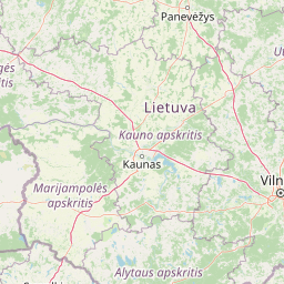
Map view of Taujeиnaи, Užeиleиnio Forest Biosphere Polygon

Use this park location map to pinpoint Taujeиnaи, Užeиleиnio Forest Biosphere Polygon in Lithuania, understand its exact geographic position, and read its mapped placement within the surrounding landscape more clearly.

Pigeon | © OpenStreetMap contributors

Location context for Taujeиnaи, Užeиleиnio Forest Biosphere Polygon

Anykščiai DistrictPanevėžys DistrictUkmergė District

Visualizing the lowland forest habitats, tree canopy structures, and peatland terrain of central Lithuania

Taujėnų–Užulėnio miškų biosferos poligonas Photos and Protected Landscape Scenery

Visual documentation reveals the extensive deciduous stands, mixed timber blocks, and wetland depressions defining the protected reserve. Examining these field photographs helps observers understand the environmental character and forest mosaic sustaining rare breeding bird species.

A narrow dirt road stretches into the distance, flanked by deciduous and coniferous trees showing early autumn foliage.

A view of a two-lane asphalt road stretching into the distance with a green park entrance sign on the right shoulder, surrounded by a grassy verge and dense forest.

Park atlas

Compare regional forest reserves and adjacent protected landscapes across central Lithuania

Parks near Taujėnų–Užulėnio miškų biosferos poligonas and surrounding protected areas

Browsing other protected areas near Taujėnų–Užulėnio miškų biosferos poligonas reveals connected lowland forest ecosystems and regional habitat reserves. Extending the geographic comparison helps trace broader conservation networks across the surrounding Baltic landscape.
Biosphere reserveUkmergė District Municipality
About 25 km away#1 closest

South

Viliukų, Karpių miškai Biosphere Reserve: Regional Protected Area Geography and Maps

Broadleaved forests and wetland ecosystems in central Lithuania

Gain insights into the protected landscape of Viliukų, Karpių miškai in the Ukmergė District. This biosphere reserve provides a detailed view of lowland forest ecosystems, characterized by spruce and birch dominance within an undulating terrain that sustains rare insect and plant communities.

Area
7.772 km²
Established
2012
Relief
Lowland
Scope
Terrestrial
Biosphere reserveAnykščiai District Municipality
About 30 km away#2 closest

Northeast

Šimonių Giria Biosphere Reserve in Anykščiai District Municipality, Lithuania

Protected forest massif and glacial landscape mapping

Šimonių giria stands as a prominent biosphere reserve in northern Lithuania, offering an expansive, pine dominated woodland defined by post glacial sands, extensive peat bogs, and a network of interior lakes. This structured overview details the park geographical features, from its role in the Natura 2000 network to its critical function as a biodiversity monitoring site within the Anykščiai District Municipality.

Area
232.61 km²
Established
2004
Relief
Lowland
Climate
Temperate
Biosphere reserveKauno rajonas
About 71 km away#3 closest

Southwest

Babtų-Varluvos miškų biosferos poligonas: Protected Forest Landscapes and Geographic Mapping

Essential woodland corridors in Kaunas district, Lithuania

Babtų-Varluvos miškų biosferos poligonas functions as a significant biosphere reserve focused on mature lowland forest conservation. This protected area offers a look at continuous woodland structures, research-focused biodiversity monitoring, and the spatial significance of forest corridors within central Lithuanian geography.

Area
44.19 km²
Established
2004
IUCN
VI
Relief
Lowland
Watercolor painting of a lake surrounded by trees with a sunset sky
National parkLithuania
About 74 km away#4 closest

East

Aukštaitija National Park: Lithuania's Oldest National Park and Protected Landscape Exploration

Mapped geography and lake district atlas for this Baltic region park.

Delve into Aukštaitija National Park, Lithuania's pioneering national park and a key protected area in the Baltic region. This detailed atlas entry highlights its defining geography: an extensive mosaic of over 120 lakes interwoven with ancient pine forests across undulating highlands. Understand the park's protected landscape, its mapped boundaries, and its ecological significance within Eastern Europe's natural terrain.

Area
410.56 km²
Established
1974
IUCN
II
Relief
Upland
Watercolor illustration of a wooden boardwalk path winding through a flat landscape with scattered trees, soft grasses, and muted natural colors.
Nature reserveKauno rajono savivaldybė
About 76 km away#5 closest

Southwest

Dubravos rezervatinė apyrubė: Protected Nature Reserve and Baltic Forest Geography

Central Lithuania protected landscape and wetland mapping

This nature reserve in the Kaunas district protects a rare combination of mature pine forest and open raised bog habitats. By preserving long term undisturbed ecological processes, it provides a stable reference point for forest dynamics in the region. Explore the structural complexity of these coniferous stands and the distinct wetland characteristics of this protected Baltic landscape.

Area
1.2 km²
Established
1994
IUCN
Ia
Relief
Lowland
Nature reserveŠvenčionys District Municipality
About 80 km away#6 closest

East

Kiauneliškio gamtinis rezervatas: Ancient Forest Landscapes and Protected Terrain Mapping

Nature reserve geography in Švenčionys District Municipality

Kiauneliškio gamtinis rezervatas protects 283 hectares of moist, sandy pine woodland characterized by glacial ridges and historic old-growth specimens. This site acts as an ecological reference for the Labanoro forest landscape, offering clear insights into the undulating lowland topography and rare interior habitats of eastern Lithuania.

Area
2.83 km²
IUCN
Ia
Relief
Lowland
Climate
Temperate
Nature reserveŠvenčionys District Municipality
About 82 km away#7 closest

East

Girutiškio gamtinis rezervatas Protected Area: Geographic Overview and Wetland Mapping

Labanoras Forest wetland complex in the Švenčionys District Municipality

Girutiškio gamtinis rezervatas is a strictly protected nature reserve occupying 1,400 hectares in eastern Lithuania. Defined by the Girutiškis and Beržalotas raised bogs, the area features a series of relict thermokarst lakes and dense pine forests. It remains a key site for boreal peatland conservation and hydrological study within the Baltic region, offering a rare glimpse into preserved wetland terrain.

Area
14 km²
IUCN
Ia
Watercolor painting showing green hills, trees, a body of water, and grassy vegetation
National parkLithuania
About 91 km away#8 closest

South

Trakai National Historic Park: Medieval Heritage and Lake District Protected Landscape

Explore Lithuania's historic park and its mapped geographic context.

Trakai National Historic Park offers a rich tapestry of medieval history intertwined with a captivating lake district landscape. As a protected area in southeastern Lithuania, it preserves significant architectural monuments, including the iconic Trakai Castle, set against a backdrop of interconnected lakes, forests, and wetlands. MoriAtlas provides a structured overview of its geographic boundaries and regional setting, facilitating atlas-style exploration of this historically significant protected landscape.

IUCN
V
Access
Moderate access
Scope
Mixed

Common questions about visiting, size, designation, and location context for Taujeиnaи, Užeиleиnio Forest Biosphere Polygon

Taujeиnaи, Užeиleиnio Forest Biosphere Polygon FAQs for park facts, access, geography, and protected area context

Find quick answers about Taujeиnaи, Užeиleиnio Forest Biosphere Polygon, including protected-area facts, park geography, trail and visitor context, and how the park fits into its surrounding country and regional landscape.
MoriAtlas Explorer

Continue Your Protected Areas Search Across the Global Atlas

Deepen your exploration by continuing the structured search for national parks and protected areas worldwide. Utilize the comprehensive filtering capabilities to compare different conservation landscapes and refine your understanding of global park geography. Discover more about the distribution and characteristics of protected natural areas.

Global natural geography