
Mori Atlas logo
Nature reserveTausendschrittmoor

Tracing the mapped boundaries of an essential raised bog landscape and recovering peatland ecosystem

Tausendschrittmoor Nature Reserve: A Detailed Look at Peatland Geography in Lower Saxony

(Naturschutzgebiet Tausendschrittmoor)

Tausendschrittmoor is a significant nature reserve located in the Emsland region of Lower Saxony, representing a preserved fragment of a once extensive raised bog habitat. The terrain comprises two distinct sections: an open, rewetted western bog dominated by cottongrass and peat moss, and an eastern area currently developing into dense bog woodland. As an ecological island within a heavily engineered agricultural landscape, this site offers a clear view of how peatland restoration functions in the low-lying plains of northern Germany.

raised bogHochmoorpeatlandrewettingbog woodlandmoor heath
A minimalist, flat-style illustration of a mountain valley featuring a tall waterfall cascading down a cliff, surrounded by coniferous trees and layered colorful rock formations.

Tausendschrittmoor

Nature reserve

Park overview

Structured park overview, official facts, and landscape profile for Tausendschrittmoor

Tausendschrittmoor park facts, protected area profile, and essential visitor context

Review the core facts for Tausendschrittmoor, including designation, size, terrain, visitor scale, habitats, and operating context in one park-focused overview.

About Tausendschrittmoor

Tausendschrittmoor is a compact, ecologically focused nature reserve in northwestern Germany, sitting within the broader Emsland peatland and canal landscape. Although officially classified as a Naturschutzgebiet rather than a national park, it represents an important conservation effort to preserve one of the last remaining fragments of raised bog habitat in an area where centuries of peat cutting, drainage, and agricultural conversion have transformed the surface.

The protected area lies just outside Haren (Ems), a town historically tied to the peat economy and waterway network of the region. The reserve's two separate sections are bordered by engineered features that reflect this human-altered setting. The smaller eastern part is directly adjacent to the Haren-Rütenbrock-Kanal, while the larger western part is framed by the Bundesstraße 408 to the northeast and a county road (Kreisstraße 225) to the northwest. Between these boundaries, the remaining peatland continues its slow ecological recovery.

What sets Tausendschrittmoor apart is not its size, but its ecological diversity within that size. Rewetted open bog, developing bog woodland, fragments of heath-like vegetation, and adjacent farmland edges are all present in one small reserve, giving visitors and researchers a compact view of how peatland landscapes recover and diversify over time after the cessation of peat cutting.

Quick facts and research context for Tausendschrittmoor

Tausendschrittmoor is a designated nature reserve (Naturschutzgebiet) with the official code NSG WE 190, located in the Landkreis Emsland in Lower Saxony. It lies northwest of Haren (Ems) at elevations between roughly 8 and 13 meters above sea level, on the flat North German Plain.

The reserve spans about 65.5 hectares and has been under formal protection since 17 December 1988. It is managed under the authority of the Landkreis Emsland, with oversight from the Lower Saxony agency for water management, coastal protection, and nature conservation (NLWKN). The site is recorded in the World Database on Protected Areas under WDPA ID 165840 and focuses on preserving a fragment of raised bog habitat amid a wider landscape of canals, roads, and farmland.

Protection and recognition

Examine official designation history and documented conservation records

Tausendschrittmoor Protection Status and International Recognition Records

Tausendschrittmoor maintains structured administrative documentation regarding its protected area status and global database registry records. Official conservation parameters provide transparent insight into management tracking and international recognition frameworks.

Protection details

WDPA ID
165840
Park context

Deeper park guide and search-rich context for Tausendschrittmoor

Tausendschrittmoor history, landscape, wildlife, and travel context

Explore Tausendschrittmoor through its history, landscape character, ecosystems, wildlife, conservation priorities, cultural context, and seasonal travel timing in a structured park guide built for atlas discovery and search intent.

Why Tausendschrittmoor stands out

Tausendschrittmoor is best known for protecting a surviving fragment of a raised bog, or Hochmoor, in a region where most peatlands have been drained and converted to farmland. Its two-part structure makes it a clear example of how peatland restoration can take different ecological paths even within a single small reserve. The western part has been deliberately rewetted, allowing classic raised bog vegetation such as cottongrass and peat mosses to re-establish alongside patches of moor heath with purple moor grass, heather, and bell heather. The eastern part, in contrast, is developing into bog woodland, illustrating a different trajectory of bog regeneration. Together, the two halves give the reserve an unusually complete picture of peatland recovery on a compact scale.
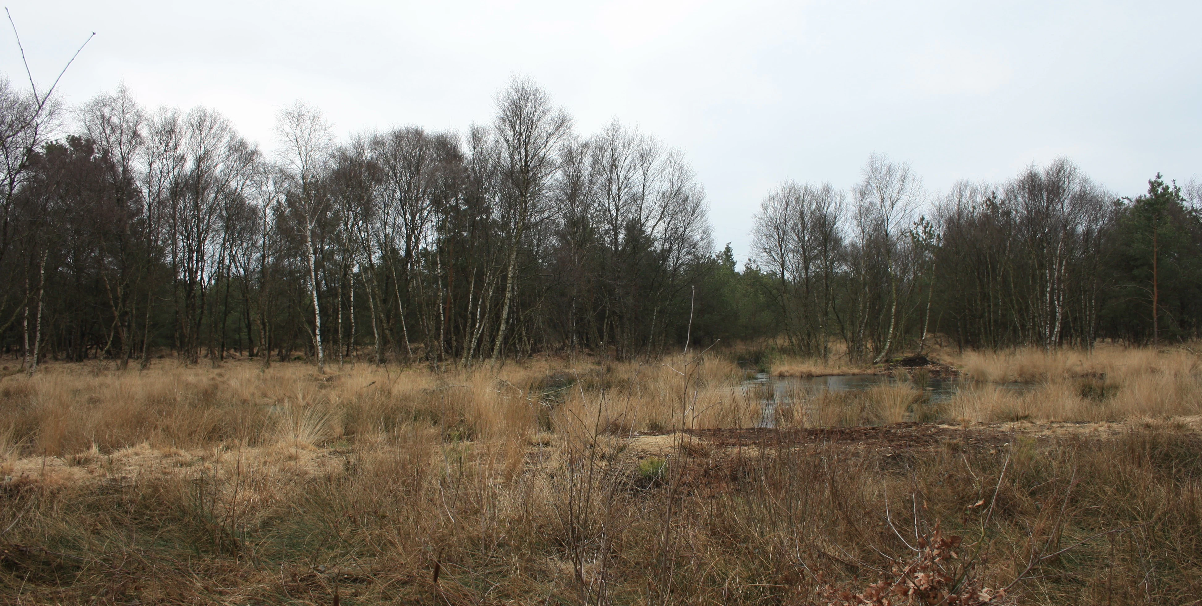
A landscape view of a marshy bog area with tall dry grasses and a small pool of water in the foreground, backed by a dense line of bare, dormant trees under an overcast sky.
The re-wetted bog landscape of Tausendschrittmoor.

Tausendschrittmoor history and protected-area timeline

Tausendschrittmoor was formally placed under nature protection on 17 December 1988, receiving the official designation NSG WE 190 under the legal framework for nature reserves in Germany. The designation came well after the region had already been extensively modified by drainage, peat cutting, and agricultural conversion, leaving only a remnant of what had once been a far larger raised bog landscape.

Before protection, the area had been partially cut for peat, an activity that left portions of the bog surface disturbed and lowered. The establishment of the reserve reflected a growing recognition, typical of late twentieth-century conservation policy in Lower Saxony, that surviving fragments of peat-forming habitat needed formal safeguarding before they were completely lost to drainage and cultivation.

After designation, restoration efforts focused on rewetting parts of the western section to halt further peat degradation and to encourage the return of typical raised bog vegetation. This placed the reserve among a wave of peatland rewetting projects in northern Germany during the 1990s and 2000s, aimed at restoring the hydrological conditions on which Hochmoor ecosystems depend.

Tausendschrittmoor landscape and geographic character

The landscape of Tausendschrittmoor is defined by the flat, low-lying character typical of the North German Plain, with elevations barely reaching 13 meters above sea level. Its terrain is shaped less by dramatic relief and more by subtle changes in moisture, peat depth, and vegetation cover across a fragment of former raised bog.

The two-part structure of the reserve shapes its visual character. The larger western section presents an open, waterlogged surface dominated by sphagnum mosses and cottongrass, interrupted by patches of moor heath where grasses and heathers take over on drier sections. The smaller eastern part has a more enclosed feel, as bog woodland slowly establishes itself, gradually giving the area a darker, more forested character despite its low overall elevation.

Surrounding the reserve is a heavily engineered landscape of canals, roads, and fields. The Haren-Rütenbrock-Kanal runs along the eastern edge, while the Bundesstraße 408 and a county road frame the western section. This juxtaposition of intact-but-fragile peatland with the straight lines of canals and roads underscores how the surviving bog exists as a small ecological island in a working agricultural and transportation landscape.

Tausendschrittmoor ecosystems, habitats, and plant life

The ecological identity of Tausendschrittmoor centers on its raised bog vegetation, which has been allowed to recover in the western section after rewetting. Sphagnum mosses form the foundation of the bog surface, accompanied by cottongrass, which contributes the soft white tufts typical of active raised bogs in early summer. Together, these species indicate the return of peat-forming conditions in the rewetted area.

Interspersed with the moss and cottongrass are patches of moor heath, where sedges such as purple moor grass mix with common heather and bell heather. These drier sections reflect the transitional state between intact bog and surrounding dryland, and they add botanical variety to the otherwise uniform wet peatland. The presence of these heath elements shows how degraded peat surfaces can support distinctive communities before full bog recovery takes hold.

In the eastern section, the ecological story shifts toward woodland. Here, bog forest species are gradually establishing, marking a different pathway of peatland regeneration in which trees and shrubs begin to dominate. Together with the open bog and the agricultural edges, this creates a mosaic of vegetation types within a compact protected area, supporting a range of microhabitats associated with different moisture and nutrient conditions.

Tausendschrittmoor conservation status and protection priorities

The conservation significance of Tausendschrittmoor lies in its role as one of the surviving fragments of raised bog habitat in the Emsland, a region where most of the original peatland has been drained and converted to agricultural use. By formally protecting this 65.5 hectare remnant, the reserve preserves a small but ecologically meaningful example of a Hochmoor ecosystem in a heavily modified landscape.

A core element of the reserve's conservation approach is rewetting, particularly in the western section, which aims to restore the high water table that raised bog vegetation depends on. Without this intervention, peat continues to oxidize, dry out, and lose its bog character, so rewetting is critical for allowing sphagnum mosses and cottongrass to re-establish and for halting further peat loss.

The reserve is managed under the authority of the Landkreis Emsland, with broader oversight from the Lower Saxony agency NLWKN, and is registered internationally in the World Database on Protected Areas. Its inclusion in this global register reflects recognition that even small, regional peatland fragments contribute to the broader network of protected peat ecosystems across northern Europe.

Top sights and standout views in Tausendschrittmoor

The reserve's most distinguishing features are its two contrasting halves: a rewetted open raised bog on the western side and a developing bog woodland on the eastern side, both preserved on the flat Emsland plain.

The site's compact size and its location amid canals, roads, and farmland make it a clear demonstration of how a small fragment of peatland can retain high ecological value within a heavily altered landscape. Its formal designation since 1988 and its inclusion in the World Database on Protected Areas mark it as a recognized component of Germany's peatland conservation network.


Monthly climate preview

Long-term temperature and precipitation records measured across representative coordinates in Lower Saxony

Tausendschrittmoor Climate Normals and Monthly Weather Patterns

Tausendschrittmoor exhibits a documented annual climate rhythm, tracking monthly mean temperatures from 1.86 degrees Celsius up to 17.92 degrees Celsius alongside consistent precipitation patterns. Reviewing the complete twelve-month profile provides deeper analytical context for long-term temperature ranges and monthly precipitation averages.
Annual mean10 °C
2 °C18 °C
Jan
Feb
Mar
Apr
May13°
Jun16°
Jul18°
Aug18°
Sep15°
Oct10°
Nov
Dec
Warmest month
July

17.9 °C

Coolest month
January

1.9 °C

Wettest month
December

2.5 mm/day

Driest month
April

1.4 mm/day

Park location guide

Geography guide, regional context, and park location map for Tausendschrittmoor

Tausendschrittmoor park geography, regions, and map view in Germany

Understand where Tausendschrittmoor sits in Germany through a broader geographic reading of the surrounding landscape, nearby location context, and its mapped position within the national park landscape.

How Tausendschrittmoor fits into Germany

Germany is a federal republic in Western and Central Europe with a population of over 83 million across sixteen constituent states. It is Europe's largest economy by nominal GDP and a major global exporter and importer. The capital is Berlin, and the country borders Denmark, Poland, Czech Republic, Austria, Switzerland, France, Luxembourg, Belgium, and the Netherlands.

Wider geography shaping Tausendschrittmoor in Germany

Germany is located in Western and Central Europe, spanning 357,022 km². It borders Denmark to the north, Poland and the Czech Republic to the east, Austria and Switzerland to the south, and France, Luxembourg, Belgium, and the Netherlands to the west. The country has coastlines on the Baltic Sea and North Sea to the north, with the Alps located in the southern region.

Map view of Tausendschrittmoor

Use this park location map to pinpoint Tausendschrittmoor in Germany, understand its exact geographic position, and read its mapped placement within the surrounding landscape more clearly.

Pigeon | © OpenStreetMap contributors

Location context for Tausendschrittmoor

Lower Saxony

Visual reference for raised bog habitats and lowland protected terrain

Tausendschrittmoor Photos and Landscape Scenery Visual Exploration

Visual documentation reveals the distinct terrain and vegetation zones that define Tausendschrittmoor across its protected lowland acreage. Photographic records capture the contrasting characteristics of rewetted raised bogs and developing bog woodlands within the reserve.

A landscape view of a marshy bog area with tall dry grasses and a small pool of water in the foreground, backed by a dense line of bare, dormant trees under an overcast sky.

Park atlas

Compare regional wetland reserves and connected lowland conservation zones

Exploring Parks Near Tausendschrittmoor and Surrounding Protected Areas

Visitors exploring Tausendschrittmoor can continue discovering nearby nature reserves and protected lowland habitats across the Emsland region. Comparing adjacent protected areas reveals broader patterns of peatland restoration and wetland recovery within agricultural terrain.
Nature reserveLower Saxony
About 11 km away#1 closest

South

Wesuweer Moor Protected Area: A Geographic Overview of Lower Saxony Peatland Landscapes

Raised bog conservation, moor heath, and wetland restoration in Emsland

Wesuweer Moor represents a critical protected landscape in northwestern Germany. This nature reserve serves as a focal point for understanding the geography of raised bogs, documenting the impact of rewetting efforts on former peat-harvesting sites. The area provides essential context for regional moorland ecology, illustrating the distribution of bog woodland, moor heath, and managed drainage systems across the Emsland plains.

Area
4.09 km²
Established
2008
IUCN
IV
Relief
Lowland
Nature reserveEmsland
About 11 km away#2 closest

South

Versener Heidesee Nature Reserve: Mapped Protected Areas in Emsland, Lower Saxony

Heathland habitats and aquatic ecosystems in the Bourtanger Moor region

Versener Heidesee represents a significant example of post-industrial landscape reclamation, where a motorway extraction site was transformed into a protected nature reserve. The site spans 40 hectares, featuring a 16-hectare lake and managed heathland that sustains rare algae species and diverse avian populations. Its location within the International Nature Park Bourtanger Moor-Bargerveen highlights the importance of small-scale, managed terrain for regional ecological health.

Area
0.4 km²
Established
2008
Relief
Lowland
Climate
Temperate
Nature reserveEmsland
About 12 km away#3 closest

South

Südliches Versener Moor Nature Reserve: Emsland Peatland Geography and Protected Landscape

A restored raised bog within the International Nature Park Bourtanger Moor-Bargerveen

Located in Emsland, Südliches Versener Moor is a protected nature reserve defined by its history of peat extraction and ongoing rewetting efforts. The area is part of the larger Bourtanger Moor complex, featuring rare remnants of intact raised bog terrain alongside restored peatland zones that highlight regional conservation dynamics in northwestern Germany.

Area
1 km²
Established
1999
IUCN
IV
Nature reserveLandkreis Emsland
About 16 km away#4 closest

Northeast

Stillgewässer bei Kluse Nature Reserve: Geographic Overview and Protected Wetland Landscape

Mapping the distinctive aquatic corridors of Landkreis Emsland.

Stillgewässer bei Kluse features a compact yet diverse mosaic of standing water pools, floating bog fringes, and oak woodlands on sandy soils. As a protected nature reserve, it functions as a crucial ecological refuge within the Emsland agricultural landscape, offering a unique opportunity to study man-made wetlands that have evolved into mature natural habitats.

Area
0.521 km²
Established
2018
Relief
Lowland
Climate
Temperate
Nature reserveLower Saxony
About 21 km away#5 closest

Southeast

Südtannenmoor Nature Reserve in Lower Saxony: An Atlas of Protected Bog Wetlands

Mapping rare heath pool ecosystems in the Emsland region

This nature reserve protects a fragile intersection of raised-bog remnants and shallow heath pools framed by coniferous forests. The site serves as a key reference for the restoration of specialized wetland vegetation in northwestern Germany, offering a clear view of how small-scale geography influences biodiversity in the Emsland landscape.

Area
0.049 km²
Established
2009
IUCN
IV
Relief
Lowland
Nature reserveLower Saxony
About 25 km away#6 closest

Northeast

Windelberg Nature Reserve: Protected Inland Dune and Heathland Mosaic in Lower Saxony

Historic sandy heath and oak woodland conservation site

Windelberg is a significant nature reserve in the Emsland region, featuring inland dunes and juniper heathland on the Hümmling glacial ridge. This area showcases a compact mosaic of dry, acidic habitats and relict oak woodland that reflects centuries of traditional land management in northwest Germany. Its status as a protected area within the Natura 2000 network highlights its importance for regional habitat conservation.

Area
0.163 km²
Established
2009
IUCN
IV
Protected landscapeEmsland
About 28 km away#7 closest

East

Naturpark Hümmling: Geographic Overview of Emsland Protected Landscapes

Tracing glacial sand ridges, moorlands, and prehistoric cultural sites.

Naturpark Hümmling stands as a prominent protected landscape in Lower Saxony, characterized by its distinctive geest ridge, extensive raised bogs, and dense concentration of Neolithic stone monuments. The area map highlights a complex interplay of river valleys, heathland remnants, and historic cultural landmarks that define the geographical identity of this Emsland treasure.

Area
576 km²
Established
2015
Relief
Upland
Climate
Temperate
National parkDrenthe
About 28 km away#8 closest

Northwest

Drentsche Aa National Park: Preserved Cultural Landscape & River Valley Geography

Explore Drenthe's unique protected lands and mapped terrain.

Drentsche Aa National Park stands as a testament to a landscape preserved from the mid-19th century, offering a rare glimpse into traditional Dutch rural life. Situated in the province of Drenthe, this protected area features one of the last relatively untouched river systems in the Netherlands, characterized by meandering brooks, ancient hedgerows, and distinctive esdorp villages. The park's geography is influenced by the Saalien ice age Hondsrug ridge, creating a unique terrain of heathlands, sand dunes, and rolling landscapes ideal for atlas-based discovery.

Area
100 km²
Established
2002
IUCN
II
Relief
Lowland

Common questions about visiting, size, designation, and location context for Tausendschrittmoor

Tausendschrittmoor FAQs for park facts, access, geography, and protected area context

Find quick answers about Tausendschrittmoor, including protected-area facts, park geography, trail and visitor context, and how the park fits into its surrounding country and regional landscape.
MoriAtlas Explorer

Continue Your Protected Areas Search Across the Global Atlas

Deepen your exploration by continuing the structured search for national parks and protected areas worldwide. Utilize the comprehensive filtering capabilities to compare different conservation landscapes and refine your understanding of global park geography. Discover more about the distribution and characteristics of protected natural areas.

Global natural geography