
Mori Atlas logo
Protected landscapeTenczyński Park Krajobrazowy

Mapping the natural terrain and forest mosaics west of Kraków in Lesser Poland Voivodeship

Tenczyński Park Krajobrazowy: A Protected Landscape of Limestone Ridges and Karst Geography

Tenczyński Park Krajobrazowy stands as a distinct protected landscape within Lesser Poland Voivodeship, characterized by the Garb Tenczyński ridge and its complex geological foundations. This area blends Upper Jurassic limestone outcrops, Paleozoic volcanic rock, and marshy lowlands to create a varied environment for beech and pine forests. Beyond its natural geography, the region preserves historical landmarks, including the ruins of Tenczyn and Lipowiec castles, which remain integrated within the protected terrain.

limestone uplandkarst landscapebeech forestspine forestsmixed woodlandwetlands
A stylized digital illustration of a deep mountain valley at sunrise, featuring towering cliffs, a waterfall in the distance, pine trees in the foreground, and layers of mist.

Tenczyński Park Krajobrazowy

Protected landscape

Park overview

Structured park overview, official facts, and landscape profile for Tenczyński Landscape Park

Tenczyński Landscape Park park facts, protected area profile, and essential visitor context

Review the core facts for Tenczyński Landscape Park, including designation, size, terrain, visitor scale, habitats, and operating context in one park-focused overview.

About Tenczyński Landscape Park

Tenczyński Landscape Park occupies a transitional zone between the urban influence of Kraków and the wider Jurassic landscapes of the Kraków-Częstochowa Upland. Its position west of the city, across nine communes including parts of Kraków itself, makes it one of the most accessible protected areas in southern Poland and gives it a role as both a regional recreational space and a meaningful conservation area.

Geologically, the park sits within a varied sector of the upland. The Garb Tenczyński ridge is built largely of Upper Jurassic limestone, which has been shaped by long karst processes into residual outcrops, rock walls, and small cave systems. Among these limestone features are exposures of Paleozoic hard rocks of volcanic origin, producing a geological mix that is unusual for the region. In the lower sections, particularly toward the Rów Krzeszowicki, loess cover and waterlogging create marshy conditions, adding wetland habitats to the park's range of environments.

Ecologically, the park is defined more by diversity than by a single dominant ecosystem. Carpathian beech forests (żyzna buczyna karpacka) occupy favorable slopes, while mixed pine-oak forests and oak-hornbeam communities with beech, oak, and sycamore maple are widespread. Riverine alder groves follow watercourses, and in the eastern part the Dulowska Forest introduces extensive pine forest communities. Wetland patchiness supports marsh violets, sundews, and other moisture-dependent species.

Culturally, the park's landscape is inseparable from a layered human history. The ruins of Tenczyn Castle near Rudno and Lipowiec Castle near Babice are major landmarks, complemented by Baroque churches in Tenczynek and Morawica, four former Austro-Hungarian forts around the edge of Kraków, and the Radziwiłł Palace complex at Balice. Together these sites reflect centuries of settlement, defensive, and aristocratic activity in the area.

Protection within the park is reinforced by five nature reserves, which collectively guard representative examples of its forests, valley habitats, and rock outcrops, ensuring that the park's principal natural values remain intact despite its proximity to a major metropolitan area.

Quick facts and research context for Tenczyński Landscape Park

Tenczyński Landscape Park lies west of Kraków in the Lesser Poland Voivodeship and is one of the component parks of the former Jurassic Landscape Parks group, now part of the Małopolska Voivodeship Landscape Park System. The park was originally established in 1981 and was formally separated within the system by a 2005 regulation of the Małopolska Voivodeship governor.

It covers the Garb Tenczyński ridge and adjacent parts of the Rów Krzeszowicki, a geologically varied sector of the Kraków-Częstochowa Upland. Forests make up roughly a third of its area, and within its boundaries there are five nature reserves protecting key woodland, valley, and rock-outcrop sites.

Protection and recognition

Terrestrial conservation framework and official recognition records

Tenczyński Park Krajobrazowy Protection Status and Designation Details

Documented protection parameters outline the terrestrial scope and administrative framework governing Tenczyński Park Krajobrazowy. Verified conservation records assemble designated boundaries and management data for structural analysis.

Protection details

Protection scope
Terrestrial
Transboundary protection
No
Buffer area
134.14 km²
Park context

Deeper park guide and search-rich context for Tenczyński Landscape Park

Tenczyński Landscape Park history, landscape, wildlife, and travel context

Explore Tenczyński Landscape Park through its history, landscape character, ecosystems, wildlife, conservation priorities, cultural context, and seasonal travel timing in a structured park guide built for atlas discovery and search intent.

Why Tenczyński Landscape Park stands out

The park is best known for the Garb Tenczyński ridge, a distinctive geomorphological feature of the Kraków-Częstochowa Upland where Upper Jurassic limestone has been sculpted by karst processes into residual rocky outcrops, small caves, and Paleozoic volcanic rock exposures. This combination of compact karst scenery near Kraków is the park's principal geographic signature. It is also recognized for the variety of plant communities packed into a relatively small footprint, ranging from Carpathian beech forests and mixed oak-pine woodlands to riverine alder stands and the pine-dominated Dulowska Forest. On top of this ecological richness, the park is noted for housing two prominent medieval castle ruins, Tenczyn and Lipowiec, which give the area a strong cultural character alongside its natural landscape.
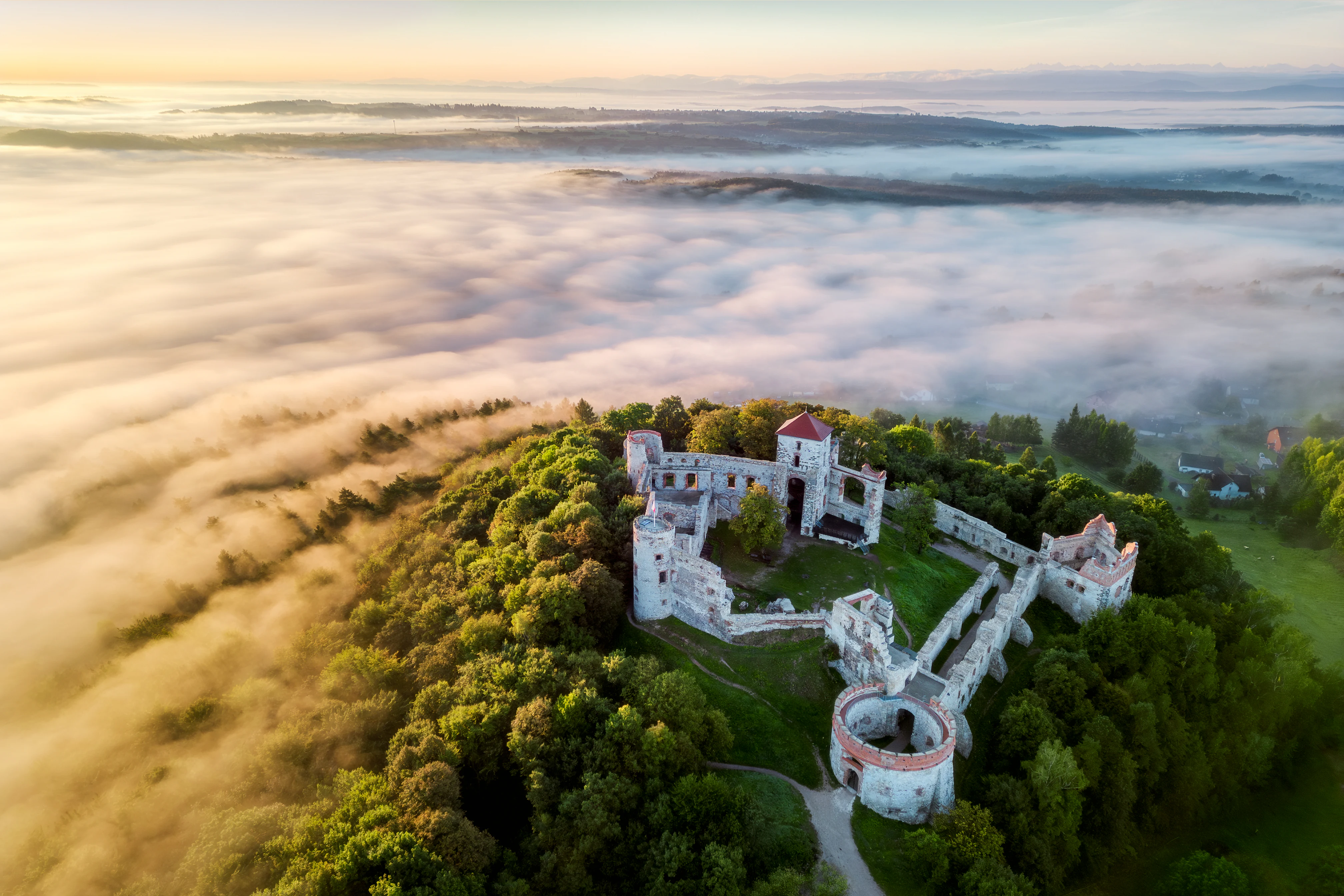
An aerial view of the stone ruins of Tenczyn Castle perched on a forested hill above a thick layer of morning fog.
Tenczyn Castle ruins seen from above, surrounded by morning mist.

Tenczyński Landscape Park history and protected-area timeline

Tenczyński Landscape Park was established in 1981 through a resolution of the National Council of the City of Kraków, alongside other units that together formed the Jurassic Landscape Parks group. This grouping was later reorganized and is now known as the Landscape Parks System of the Małopolska Voivodeship (Zespół Parków Krajobrazowych Województwa Małopolskiego).

Within that administrative framework, the park was formally separated by Regulation No. 79/05 of the Małopolska Voivodeship Governor, issued on 29 December 2005. This regulation established the park as an independent unit with its own boundaries and a designated buffer zone. The 2005 instrument also formalized the relationship between the park and the surrounding communes, including Alwernia, Babice, Chrzanów, Kraków, Krzeszowice, Liszki, Trzebinia, Wielka Wieś, and Zabierzów.

The park's establishment built on a longer history of landscape and castle heritage in the area. The ruins of Tenczyn Castle and Lipowiec Castle had long marked the landscape, and the Austro-Hungarian fortifications near Kraków had shaped part of the park's territory since the late 19th and early 20th centuries. The 1981 creation and 2005 reorganization represent the modern legal framework that integrates this older cultural geography with contemporary conservation goals.

Tenczyński Landscape Park landscape and geographic character

The landscape of Tenczyński Landscape Park is built around the Garb Tenczyński ridge, a clear elevated spine that runs through the central part of the protected area. The ridge exposes Upper Jurassic limestone that has been shaped by karst processes into residual rocky outcrops, locally dramatic rock walls, and small cave systems. Scattered Paleozoic hard rocks of volcanic origin appear among the limestones, giving the ridge a geological complexity beyond what the surrounding upland typically shows.

Beneath the ridge lies the Rów Krzeszowicki, a relative depression where loess deposits and flat terrain produce softer, more agricultural-looking scenery. In this lower zone, waterlogged ground has created marshy pockets, and the contrast between the rocky ridge above and the marshy, gently sloping ground below is one of the park's defining visual features. A mix of plains, small valleys, and watercourses further breaks up the terrain.

From the upland west of Kraków, the park offers panoramas typical of the Kraków-Częstochowa Upland, including combinations of woodland ridges, exposed limestone, and patchwork farmland, all within easy reach of the metropolitan edge. The presence of castle ruins on prominent outcrops reinforces the traditional identity of the karst landscape.
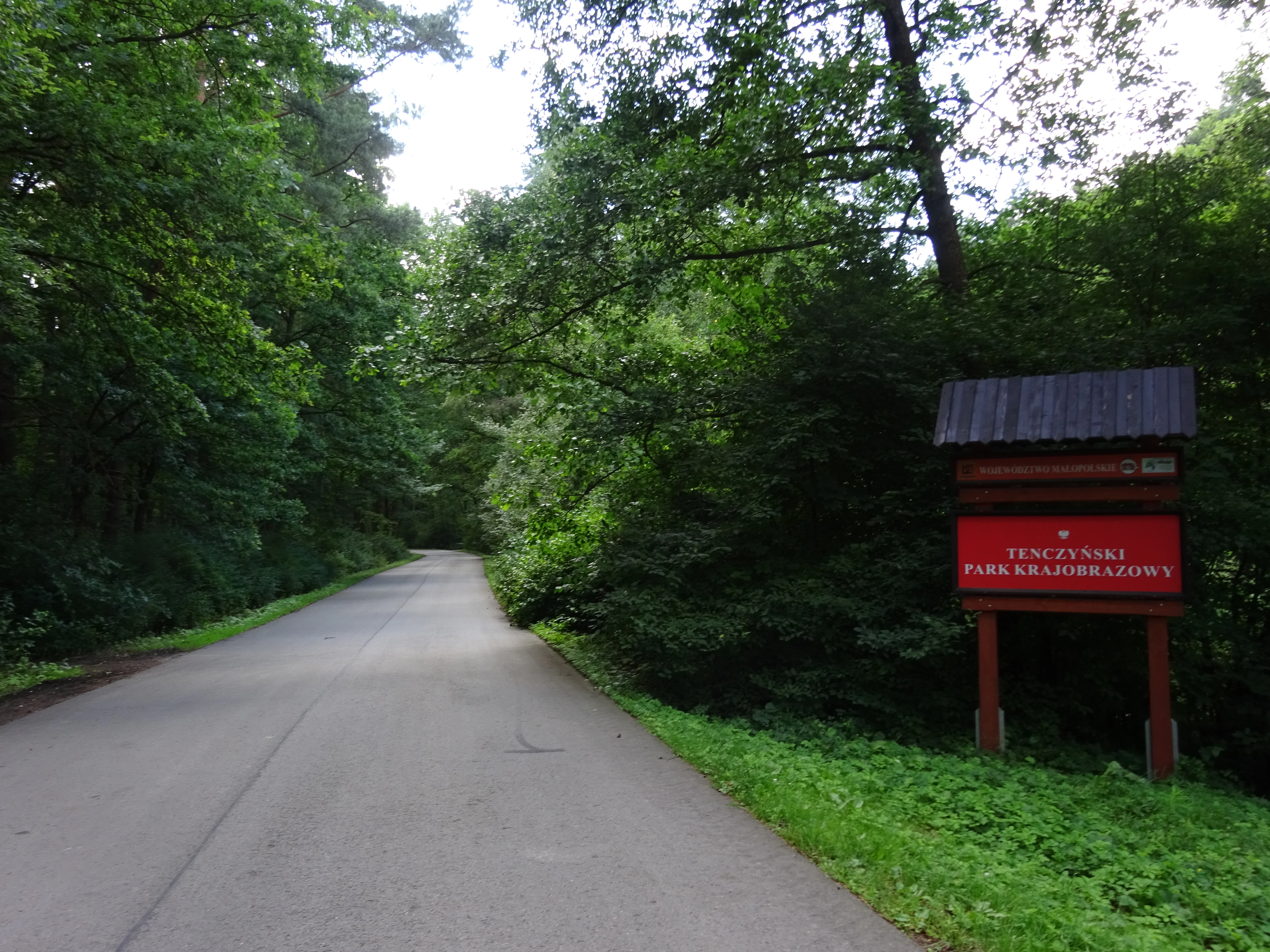
An asphalt road leads into a dense green forest, with a red park entrance sign on the right side of the road.
An official sign marking the eastern entrance of Tenczyński Landscape Park near Tenczynek.

Tenczyński Landscape Park ecosystems, habitats, and plant life

The park protects a notably compact mosaic of habitats. Forests cover roughly a third of its area, and they range from Carpathian beech forests on the best-developed soils to mixed pine-oak communities on lighter substrates. Oak-hornbeam (grąd) forests with beech, oak, and sycamore maple occupy transitional sites, while alder-dominated riverine woods (łęgi olszowe) follow streams and wet pockets.

In the eastern sector, the Dulowska Forest introduces extensive pine forests (bory sosnowe) on sandy soils, creating a different character from the rest of the park. Wetland microhabitats are scattered across the lower terrain, particularly in the Rów Krzeszowicki, supporting moisture-dependent flora such as bog violet and round-leaved sundew, alongside marsh vegetation in raw peat-like conditions.

Protected plant species documented within the park include houseleek, Moldavian monkshood, common ivy, marsh violet, Turk's cap lily, sweet woodruff, wood meadowsweet, round-leaved sundew, lesser periwinkle, and giant horsetail. The combination of dry limestone ridges, mesic woodland slopes, and wet lowland pockets explains how so many distinct species can occur within such a limited area.

Tenczyński Landscape Park wildlife and species highlights

Although sources on the park's fauna are limited, the habitat diversity described above supports a recognizable range of animal life. Forest mammals typical of southern Poland's mixed woodland are present in the park, including moose, which are noted among the protected fauna in the area. Open and semi-open habitats in the park's lower sections provide conditions for ground-nesting birds and damp-loving species.

Documented and protected bird species include the sparrowhawk, barn owl, common buzzard, northern lapwing, and corncrake, indicating a mix of woodland raptors, open-country waders, and owls that reflect the park's combination of forest, wetland, and agricultural edge. The presence of the European pond turtle (żółw błotny) underscores the conservation value of the park's wetland pockets for reptile and amphibian fauna reliant on standing and slow-moving water.

The mosaic of forest, marsh, and cultivated land gives the park an unusually broad faunal profile for its size. This is reinforced by five nature reserves within the park: Bukowica, Dolina Mnikowska, Lipowiec, Skała Kmity, and Zimny Dół, which collectively protect representative forest stands, valley habitats, and rock outcrop communities that sustain local wildlife.

Tenczyński Landscape Park conservation status and protection priorities

Tenczyński Landscape Park has conservation importance that extends beyond its immediate scenic qualities. It protects a transitional landscape between the heavily populated Kraków area and the wider Kraków-Częstochowa Upland, maintaining ecological corridors, woodland continuity, and habitat variety within easy reach of a major urban center.

Its designation under the Małopolska Landscape Parks System gives it a formal role in safeguarding karst geomorphology, Jurassic limestone outcrops, and associated plant communities, including several legally protected plant species. The park also shelters wetlands that support species such as the European pond turtle and a range of moisture-dependent plants, contributing to biodiversity preservation at the regional scale.

A network of five nature reserves within the park, covering forest reserves, a valley reserve, and rock outcrop reserves, strengthens its conservation framework. These reserves concentrate protection on sites that best represent the park's principal natural values, including old-growth forest patches and ecologically important valley habitats.

Tenczyński Landscape Park cultural meaning and human context

The area protected by the park carries a rich cultural layer that has long shaped how it is perceived. The ruins of Tenczyn Castle near Rudno and Lipowiec Castle near Babice are prominent historical landmarks set directly within the landscape, and they have come to symbolize the identity of the Garb Tenczyński region.

Religious architecture within and near the park includes Baroque churches in Tenczynek and Morawica, which anchor several of the area's villages and reflect the Catholic heritage of the region. On the eastern, Kraków-facing edge of the park, four former Austro-Hungarian forts reflect the area's late 19th- and early 20th-century military history, while the Radziwiłł Palace complex in Balice represents the aristocratic architectural heritage of the late historical period.

The intersection of castles, Baroque villages, fort systems, and noble residences gives the park an unusually dense cultural footprint for a relatively compact protected area, and these sites are central to how the landscape around Kraków's western edge is understood both locally and regionally.

Top sights and standout views in Tenczyński Landscape Park

Tenczyński Landscape Park's standout feature is the interplay between the Garb Tenczyński ridge with its karst-shaped limestone outcrops and the marshy Rów Krzeszowicki below, a contrast that defines the park's visual and ecological identity.

Equally distinctive is the combination of medieval heritage with natural landscape, exemplified by the ruins of Tenczyn Castle and Lipowiec Castle set among forests, complemented by Baroque churches, Austro-Hungarian forts, and the Balice palace complex on the Kraków side.

Finally, the park's compact ecological richness, anchored by Carpathian beech forests, mixed pine-oak woods, the pine-dominated Dulowska Forest, and protected species such as the European pond turtle, gives it a strong conservation profile that belies its proximity to one of Poland's largest cities.

Best time to visit Tenczyński Landscape Park

Because the park lies at low elevation on the Kraków-Częstochowa Upland, conditions are broadly accessible year-round. Spring is a particularly rewarding time, as woodland understory species come into leaf and marsh vegetation in the lower sections becomes more visible, while deciduous forests including Carpathian beech stands show fresh growth.

Summer offers the most active wildlife viewing opportunities in open habitats and wetland margins, and is well suited to longer walks across both the rocky ridge and the lower-lying sections. Autumn highlights the beech and oak communities at their most colorful, especially in mixed woodland areas around the ridge.

Winter reduces foliage cover, which can actually benefit visitors interested in the park's geological features, as exposed limestone outcrops, castle ruins, and small caves are more easily seen, though some paths may be more demanding under colder conditions.

Monthly climate preview

Long-term representative point measurements tracking annual temperature and precipitation rhythm

Tenczyński Park Krajobrazowy Climate and Monthly Temperature Normals

Long-term records reveal measured monthly temperature shifts alongside consistent precipitation patterns across the protected landscape. Examining the comprehensive twelve-month climate profile provides deeper context for regional meteorological conditions at the reference coordinate.
Annual mean8 °C
-4 °C19 °C
Jan-4°
Feb-2°
Mar
Apr
May13°
Jun17°
Jul19°
Aug19°
Sep14°
Oct
Nov
Dec-2°
Warmest month
July

19.2 °C

Coolest month
January

-3.5 °C

Wettest month
July

3.5 mm/day

Driest month
December

1.5 mm/day

Park location guide

Geography guide, regional context, and park location map for Tenczyński Landscape Park

Tenczyński Landscape Park park geography, regions, and map view in Poland

Understand where Tenczyński Landscape Park sits in Poland through a broader geographic reading of the surrounding landscape, nearby location context, and its mapped position within the national park landscape.

How Tenczyński Landscape Park fits into Poland

Poland, officially the Republic of Poland, is a Central European country spanning from the Baltic Sea in the north to the Carpathian Mountains in the south. It borders Germany, Czech Republic, Slovakia, Ukraine, Belarus, Lithuania, and Kaliningrad Oblast. The country has a temperate climate, diverse landscapes, and is known for its rich history, cultural heritage, and strong economic position within the EU.

Wider geography shaping Tenczyński Landscape Park in Poland

Poland occupies 312,696 km2 in Central Europe, extending from the Baltic Sea coast in the north to the Sudetes and Carpathian Mountains in the south. It borders Germany to the west, Czech Republic and Slovakia to the south, Ukraine and Belarus to the east, and Lithuania and Kaliningrad Oblast to the northeast. The landscape includes lowland plains, uplands, and mountain ranges.

Map view of Tenczyński Landscape Park

Use this park location map to pinpoint Tenczyński Landscape Park in Poland, understand its exact geographic position, and read its mapped placement within the surrounding landscape more clearly.

Pigeon | © OpenStreetMap contributors

Location context for Tenczyński Landscape Park

Lesser Poland Voivodeship

Visualizing the karst terrain, limestone outcrops, and forest habitats of Tenczyński Park Krajobrazowy

Tenczyński Park Krajobrazowy Photos and Landscapes

Visual records reveal the distinctive topography of Tenczyński Park Krajobrazowy, capturing the interplay between limestone ridges, volcanic outcrops, and marshy lowlands. Detailed imagery documents the varied habitats and protected landscapes that define this upland region west of Kraków.

An aerial view of the stone ruins of Tenczyn Castle perched on a forested hill above a thick layer of morning fog.

A low-angle view of the weathered stone ruins of Lipowiec Castle, featuring a prominent circular tower and an adjacent wooden footbridge leading to the castle entrance.

An asphalt road leads into a dense green forest, with a red park entrance sign on the right side of the road.

Park atlas

Compare adjacent protected areas, limestone ridges, and regional natural heritage

Other Parks Near Tenczyński Park Krajobrazowy for Regional Landscape Comparison

Browsing parks near Tenczyński Park Krajobrazowy reveals continuous protected landscapes across the surrounding upland terrain. Extending the geographic review allows direct comparison of neighboring forest reserves, karst formations, and regional park boundaries.
A soft watercolor painting of a winding stream flowing through a green valley with light trees, under a pale pink and yellow sky.
Nature reservePoland
About 4.7 km away#1 closest

Southwest

Rezerwat przyrody Dolina Potoku Rudno: Nature Reserve and Protected Landscape Atlas

Geographic map and protected forest terrain in Lesser Poland

Situated in the Rudno Stream valley, this nature reserve offers a detailed look at preserved alder floodplain ecosystems and rocky gorge formations. The area provides a critical protected woodland link within the Kraków-Częstochowa Upland. Use the atlas data to examine the reserve boundaries, geological exposures, and regional landscape connections in Poland.

Area
0.959 km²
Established
2001
Relief
Upland
Climate
Temperate
A horizontal watercolor illustration showing a peaceful river flowing through a lush green valley with distant rolling hills and wild grasses in the foreground.
Nature reserveLesser Poland Voivodeship
About 5.9 km away#2 closest

Southeast

Rezerwat przyrody Dolina Mnikowska: A Karst Landscape Reserve in Lesser Poland

Mapped limestone gorge and forest protected area geography

Rezerwat przyrody Dolina Mnikowska features a striking limestone gorge and forest ecosystem within the Lesser Poland Voivodeship. This protected area offers a deep look into the karst topography, river-carved cliffs, and diverse habitat zones of the Garb Tenczyński upland region.

Area
0.209 km²
Established
1963
Relief
Upland
Climate
Temperate
Protected areaLesser Poland Voivodeship
About 7.6 km away#3 closest

South

Rudniańskie Modraszki, Kajasówka: Protected Area Geography and Habitat Mapping

Lesser Poland Voivodeship, Southern Poland

Rudniańskie Modraszki, Kajasówka represents a core conservation zone defined by its rare xerothermic and molinia meadow habitats. Spanning the transition between ridge and depression landscapes, this area provides a structured look at how small-scale habitat protection supports essential butterfly populations within the diverse geography of southern Poland.

Area
4.25 km²
Established
2011
Relief
Upland
Scope
Terrestrial
Watercolor painting of a pastoral landscape featuring soft, rolling hills, a line of trees, and muted earth tones, presented as a wide, horizontal strip.
Nature reserveLesser Poland Voivodeship
About 8.1 km away#4 closest

North

Dolina Eliaszówki Nature Reserve: Protected Karst Valley and Forest Geography in Lesser Poland

A study of limestone outcrops and mature forest habitats in southern Poland

Dolina Eliaszówki Nature Reserve encompasses a deeply incised limestone valley characterized by diverse forest communities and complex karst geomorphology. The reserve protects an integrated network of rock outcrops, caves, and springs, framing historical monastic landmarks within a continuous protected forest corridor. It offers an essential view into the layered natural and cultural history of the Kraków-Częstochowa Upland.

Area
1.096 km²
Established
1989
Relief
Upland
Climate
Temperate
Watercolor painting of a valley landscape with rolling hills, limestone rock formations on the right, and soft green vegetation.
Nature reserveLesser Poland Voivodeship
About 8.4 km away#5 closest

North

Rezerwat przyrody Dolina Racławki: Protected Limestone Valley and Karst Geography

Explore the forest mosaic and geological cliff features in Lesser Poland

The Rezerwat przyrody Dolina Racławki landscape reserve is a significant protected area in the Olkuska Upland. Spanning a long limestone valley, the reserve features a network of caves, rock shelters, and steep cliffs built from Carboniferous and Jurassic bedrock. Its combination of layered forest communities and protected orchid populations marks it as a vital site for understanding the natural heritage and regional geography of southern Poland.

Area
4.739 km²
Established
1962
Relief
Upland
Climate
Temperate
Watercolor painting of a rolling landscape featuring a line of evergreen trees and soft hills under a light, warm sky.
Nature reserveLesser Poland Voivodeship
About 12 km away#6 closest

Northeast

Dolina Szklarki Nature Reserve: Atlas Map and Protected Landscape Geography

Exploring forest communities and limestone rock formations in Lesser Poland.

Analyze the protected geography of Dolina Szklarki Nature Reserve, a key nature reserve in the Kraków-Częstochowa Upland. The area features a dense concentration of limestone cliffs, distinct forest ecosystems, and karst valley terrain within Lesser Poland Voivodeship.

Area
0.467 km²
Established
1989
Relief
Upland
Climate
Temperate
A flat-style vector illustration showing a winding river flowing through a lush green valley towards a large mountain with a waterfall, surrounded by trees and stylized clouds.
Nature reserveLesser Poland Voivodeship
About 14 km away#7 closest

Northeast

Rezerwat przyrody Dolina Kluczwody: Karst Valley and Protected Nature Reserve Geography

Exploring the limestone cliffs of Lesser Poland Voivodeship

Dolina Kluczwody represents a quintessential limestone valley landscape in southern Poland, featuring a blend of forest cover and exposed rock swards. As a protected nature reserve, it forms a crucial habitat within the Dolinki Krakowskie complex, preserving unique karst terrain and stream-fed ecosystems for scientific and environmental monitoring.

Area
0.352 km²
Established
1989
Relief
Upland
Climate
Temperate
Watercolor illustration showing green hills, scattered trees, and a light sky background
National parkLesser Poland Voivodeship
About 15 km away#8 closest

Northeast

Ojców National Park: Karst Geography and Protected Landscape Atlas Entry

Explore the mapped terrain and unique geology of this national park.

Ojców National Park, situated in Lesser Poland Voivodeship, offers a concentrated display of dramatic karst topography. This protected national park is renowned for its towering limestone cliffs, intricate ravines, and over 400 caves, showcasing a unique Jurassic geology. As a vital protected area, its mapped boundaries encompass distinctive rock formations like Hercules' Club and the historic Trail of the Eagles' Nests, providing rich context for landscape discovery and atlas exploration.

Area
21.46 km²
Established
1956
IUCN
II
Relief
Upland

Common questions about visiting, size, designation, and location context for Tenczyński Landscape Park

Tenczyński Landscape Park FAQs for park facts, access, geography, and protected area context

Find quick answers about Tenczyński Landscape Park, including protected-area facts, park geography, trail and visitor context, and how the park fits into its surrounding country and regional landscape.
MoriAtlas Explorer

Continue Your Protected Areas Search Across the Global Atlas

Deepen your exploration by continuing the structured search for national parks and protected areas worldwide. Utilize the comprehensive filtering capabilities to compare different conservation landscapes and refine your understanding of global park geography. Discover more about the distribution and characteristics of protected natural areas.

Global natural geography