

Mori Atlas logo
Nature reserveTnorala Conservation Reserve

Mapping the dramatic circular impact structure and arid basin terrain within Australia's central desert

Tnorala Conservation Reserve: Protected Geological Landscapes and Cultural Heritage in Northern Territory

Tnorala Conservation Reserve protects a globally recognized impact structure, appearing as an unmistakable circular ring of rugged hills rising above the desert plains of the Northern Territory. This protected area preserves both the deeply eroded geological remnants of a massive Cretaceous-period crater and a sacred site within Western Arrernte tradition. The landscape reveals a complex history where ancient scientific phenomena and enduring cultural narratives converge within an arid, open terrain.

impact cratergeological heritagearid landscapedesert plainssacred siteAboriginal heritage

Tnorala Conservation Reserve

Nature reserve

Park overview

Structured park overview, official facts, and landscape profile for Tnorala Conservation Reserve

Tnorala Conservation Reserve park facts, protected area profile, and essential visitor context

Review the core facts for Tnorala Conservation Reserve, including designation, size, terrain, visitor scale, habitats, and operating context in one park-focused overview.

About Tnorala Conservation Reserve

Tnorala Conservation Reserve protects a remarkable circular landform in the arid interior of Australia, in the southern part of the Northern Territory. The reserve is not defined by forests, coastlines, or wetlands, but rather by a single dominant feature: a near-perfect ring of rocky hills rising abruptly out of the surrounding desert plain. This ring frames a quieter, flat inner basin and stands out clearly against the muted tones of central Australia's arid landscape.

The reserve lies in the MacDonnell region, an area characterised by broad desert plains punctuated by isolated ranges and weathered ridges. The climate is harsh and dry, with hot summer days, cold winter nights, and relatively sparse vegetation dominated by spinifex, acacia scrub, and hardy desert species. The setting is remote, and visitors experience the kind of vast, open horizons typical of the central Australian outback, with the striking geometry of the ring forming a dramatic focal point in an otherwise continuous landscape.

Tnorala's significance rests on two overlapping dimensions. Scientifically, it is recognised as the deeply eroded remains of one of the largest known impact structures in Australia, with an original crater diameter estimated at around 22 kilometres. Culturally, it carries profound meaning for the Western Arrernte people, for whom the site is part of the living cultural and spiritual landscape. The conservation reserve exists to safeguard both the geological integrity of the feature and the cultural importance of the place as a sacred site.

Quick facts and research context for Tnorala Conservation Reserve

Tnorala Conservation Reserve lies in the MacDonnell Region of the Northern Territory, roughly 175 kilometres west of Alice Springs and about 212 kilometres northeast of Uluru. The site sits within the broader arid landscape of central Australia, where flat desert country is interrupted by isolated ranges and rock formations shaped by deep geological history.

The reserve is built around a circular geological feature derived from a large ancient impact event, with the present-day ring measuring about five kilometres across and approximately 180 metres high. The site is recognised internationally as a confirmed impact structure, and it has been studied through drilling, remote imagery, and field geology since the 1960s. It also holds formal protection as a conservation reserve and as an Aboriginal sacred site.

Protection and recognition

Documented terrestrial protection scope and verified designation data

Tnorala Conservation Reserve Protection Status and International Recognition

Tnorala Conservation Reserve maintains a recorded terrestrial protection scope within the broader protected area network. Official records aggregate available designation details and management context without external international recognition sources.

Protection details

Protection scope
Terrestrial
Transboundary protection
No
Park context

Deeper park guide and search-rich context for Tnorala Conservation Reserve

Tnorala Conservation Reserve history, landscape, wildlife, and travel context

Explore Tnorala Conservation Reserve through its history, landscape character, ecosystems, wildlife, conservation priorities, cultural context, and seasonal travel timing in a structured park guide built for atlas discovery and search intent.

Why Tnorala Conservation Reserve stands out

Tnorala is best known for the dramatic circular ring of hills that defines its landscape. Although interpreted today as the deeply eroded central uplift of an enormous ancient impact crater, the feature looks remarkably like a crater when viewed on the ground, and this visual power is a defining part of the reserve's identity. The site is also widely recognised as one of the most important confirmed impact structures in Australia and a key landmark in the global catalogue of eroded asteroid or comet craters. Its scientific importance is matched by its deep cultural significance: within Western Arrernte tradition, Tnorala is a sacred site tied to a creation story involving celestial dancers and the southern constellation Corona Australis.
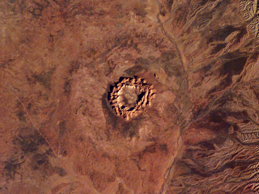
Gosses Bluff impact crater
Aerial view of the Gosses Bluff impact crater in the Northern Territory, Australia.

Tnorala Conservation Reserve history and protected-area timeline

The impact event that formed the geological foundation of Tnorala occurred in the early Cretaceous period, roughly 142.5 million years ago, when an asteroid or comet struck the area at the close of the Jurassic. The original crater is thought to have been about 22 kilometres across, but over the immense span of geological time, erosion stripped away the outer rim. What remains today is the more resistant central uplift of the impact structure, now appearing as a ring of hills roughly five kilometres in diameter and 180 metres high.

The scientific identification of the feature as an impact crater, rather than an ordinary geological formation, came in the 1960s. The strongest early evidence came from shatter cones, distinctive rock structures produced only by the intense shock pressures of a meteorite impact. Subsequent research, drilling, and remote sensing, including imagery taken from the International Space Station, have confirmed the structure's impact origin and established it as an internationally recognised geological landmark.

The modern reserve itself reflects later recognition of cultural value. Long before its scientific interpretation, the site was already deeply significant to the Western Arrernte people, for whom it has always been known as Tnorala and forms part of a sacred Dreaming story. Its formal protection as a conservation reserve, together with its recognition as an Aboriginal sacred site, reflects the contemporary Australian approach of safeguarding geological heritage alongside Indigenous cultural heritage. The naming of the feature as Gosses Bluff dates back to 1872, when explorer Ernest Giles named it after Henry Gosse, the brother of fellow explorer William Gosse.

Tnorala Conservation Reserve landscape and geographic character

The landscape of Tnorala Conservation Reserve is dominated by a single, dramatic topographic element: an almost circular ring of rugged hills that rises roughly 180 metres above the surrounding plain. The ring is about five kilometres across, and its outline is so regular that, from a distance, it resembles the rim of a fresh crater even though it is in fact a deeply eroded geological structure. The outer slopes are scarred and broken, marked by layers of uplifted rock and erosional gullies that give way to talus and stony debris around the base.

Inside the ring, the terrain flattens into a basin of arid country, with sandy or stony desert soils supporting sparse desert vegetation. Outside the ring, the reserve opens out into the wide, relatively flat country characteristic of the southern Northern Territory, where the horizon is broken only by distant ranges and the occasional mesa or isolated rocky outcrop. Visibility is typically excellent, and the clear desert light tends to sharpen the contrast between the dark, shadowed slopes of the ring and the pale, open ground around it.
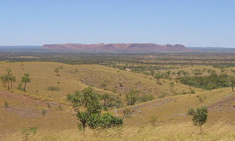
Gosse Bluff from Tylers Pass
View of the Gosse Bluff impact crater in the Northern Territory, Australia

Tnorala Conservation Reserve ecosystems, habitats, and plant life

Ecologically, Tnorala Conservation Reserve sits within the arid zone that covers most of central Australia. Vegetation is sparse and adapted to low rainfall, high daytime temperatures, and cool nights. The slopes and flanks of the ring support a denser cover of hardy shrubs and small trees than the surrounding plains, while the inner basin and the open desert around the reserve are dominated by drought-tolerant plants such as spinifex grasses, low acacias, and other typical outback scrub species.

Because of the arid climate, the reserve does not support dense forests, wetlands, or waterways, and it is the rock itself, rather than vegetation, that defines the visual experience. Life here is shaped by extremes: seasonal rains can briefly transform parts of the landscape, but for most of the year the country is dry, sun-bleached, and quiet. The reserve's ecological value lies less in lushness than in the integrity of an arid-zone environment that remains largely unmodified around a landscape feature of global geological interest.

Tnorala Conservation Reserve wildlife and species highlights

Wildlife in Tnorala Conservation Reserve reflects the broader fauna of arid central Australia rather than a uniquely rich local assemblage. Native mammals typical of the region may be present in the area, such as red kangaroos, wallabies, and a range of smaller marsupials adapted to dry conditions. Reptiles are generally well represented in rocky desert habitats of this kind, with goannas, dragons, snakes, and other lizard groups well suited to the stony slopes and sun-warmed rock of the ring.

Birdlife in and around the reserve tends to be characteristic of desert and semi-arid country, with species adapted to open ground and scattered shrub cover. Raptors such as wedge-tailed eagles are frequently recorded in similar landscapes, along with various parrots, cockatoos, and smaller desert birds. Wildlife observation in this part of Australia depends heavily on timing, water availability, and weather conditions, but the mix of rocky shelter, open foraging ground, and relative isolation provides a viable habitat structure for typical central Australian fauna.

Tnorala Conservation Reserve conservation status and protection priorities

The conservation significance of Tnorala rests on the combination of geological heritage and cultural heritage within a single protected landscape. Internationally, the impact structure is one of the better-studied examples of an eroded large-scale impact crater, and its preservation allows ongoing scientific research into impact processes, shock metamorphism, and the long-term erosional history of impact structures on Earth.

At a national and regional level, the reserve protects a landform that cannot be replaced or replicated. The central uplift of a large impact crater is a rare feature globally, and its ongoing exposure in the Australian arid zone makes it accessible for study and appreciation.

Equally, the reserve's status as a protected Aboriginal sacred site means that conservation here is not purely about ecology or geology, but also about safeguarding an active cultural landscape. The reserve represents an integrated model of land protection, recognising both the scientific importance of a globally significant impact structure and the enduring cultural importance of the place to the Western Arrernte people.

Tnorala Conservation Reserve cultural meaning and human context

For the Western Arrernte people, the site known as Tnorala is a deeply sacred place anchored in the Dreaming. According to Western Arrernte tradition, the circular formation originated when a group of celestial women were dancing as stars in the Milky Way. One of the women placed her baby in a wooden basket, or turna (coolamon), and during the dance the basket slipped and fell to the earth. The force of the impact pushed the rocks upward, creating the ring of hills, while the baby's parents, the evening star and the morning star, are said to still be searching for their child.

The turna itself is identified with the constellation Corona Australis, visible in the southern sky, linking the landscape directly to the celestial realm. As a sacred site, Tnorala is protected under Australian Aboriginal heritage arrangements in addition to its reserve status, reflecting the continuing importance of the place in Western Arrernte culture and cosmology.

Top sights and standout views in Tnorala Conservation Reserve

The defining highlight of Tnorala is its circular ring of hills, which appears at the surface as a clear, almost geometric loop rising sharply from the surrounding plain. This ring is the visible remnant of the central uplift of an impact crater that originally spanned roughly 22 kilometres, but has been eroded over more than 140 million years into the present five-kilometre-wide feature.

Equally compelling is the layered story of the place: the scientific importance of a confirmed impact structure, the visual drama of a near-crater-like landform in the Australian outback, and the enduring Western Arrernte Dreaming story that connects the geology to the sky. Few conservation reserves in Australia combine a globally recognised geological feature with such a strongly anchored cultural narrative.

Best time to visit Tnorala Conservation Reserve

The climate around Tnorala is typical of central Australia, with hot summers, cool winters, and limited rainfall concentrated into short, sometimes intense seasons. Winter and the shoulder months, broadly spanning the cooler half of the year, tend to offer more comfortable conditions for visiting remote arid landscapes, with milder daytime temperatures, cooler nights, and generally clearer skies for appreciating the geometry of the ring and the surrounding desert.

Summer visits are possible but can be physically demanding due to extreme heat, while the warmer months may bring local storms that briefly transform the appearance of the landscape and bring wildlife activity around any available water. Travellers planning a visit should expect conditions shaped by remoteness and aridity in any season, with cooler periods generally offering the most comfortable experience of the reserve's open horizons and stark geological setting.

Monthly climate preview

Long-term monthly temperature and precipitation patterns across the protected landscape

Tnorala Conservation Reserve Climate Normals and Annual Weather Rhythm

Representative coordinate records show measured long-term averages spanning high summer maximums down to cooler winter minimums alongside low daily precipitation rates. Reviewing the complete twelve-month climatology profile provides deeper baseline insight into historical temperature swings and rainfall distribution across Tnorala Conservation Reserve.
Annual mean22 °C
12 °C30 °C
Jan30°
Feb29°
Mar26°
Apr22°
May16°
Jun12°
Jul12°
Aug15°
Sep20°
Oct24°
Nov27°
Dec29°
Warmest month
January

30 °C

Coolest month
July

12.3 °C

Wettest month
February

1.5 mm/day

Driest month
August

0.1 mm/day

Park location guide

Geography guide, regional context, and park location map for Tnorala Conservation Reserve

Tnorala Conservation Reserve park geography, regions, and map view in Australia

Understand where Tnorala Conservation Reserve sits in Australia through a broader geographic reading of the surrounding landscape, nearby location context, and its mapped position within the national park landscape.

How Tnorala Conservation Reserve fits into Australia

Australia is a constitutional monarchy and federal parliamentary democracy comprising six states and ten territories. With a population of nearly 28 million, it is one of the world's most urbanised countries, with most people concentrated on the eastern seaboard. The country has a high Human Development Index and is known for its cultural diversity, ancient Aboriginal heritage, and unique wildlife.

Wider geography shaping Tnorala Conservation Reserve in Australia

Australia occupies the entire Australian continent, the island of Tasmania, and numerous smaller islands. It is the world's flattest and driest inhabited continent, featuring vast deserts in the interior (the Outback), tropical rainforests along the eastern coast, and a coastline bordering the Indian and Pacific Oceans.

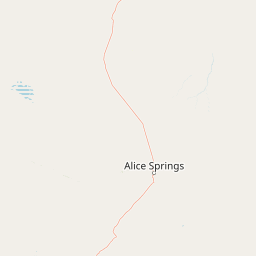
Map view of Tnorala Conservation Reserve

Use this park location map to pinpoint Tnorala Conservation Reserve in Australia, understand its exact geographic position, and read its mapped placement within the surrounding landscape more clearly.

Pigeon | © OpenStreetMap contributors

Location context for Tnorala Conservation Reserve

Northern Territory

Explore protected area scenery, geological terrain, and arid desert habitats across the reserve.

Tnorala Conservation Reserve Photos and Landscapes: Visualizing the Ancient Impact Crater

Visual documentation reveals the dramatic circular ring of rugged hills and stark desert plains that define the protected landscape. Examining terrain photography helps observers understand the geological formation and remote environmental character of the central Australian outback.

Gosses Bluff impact crater

Gosses Bluff crater from space

Gosse Bluff from Tylers Pass

Park atlas

Compare regional protected areas and connected geological reserves across central Australia.

Explore Parks Near Tnorala Conservation Reserve and Surrounding Desert Landscapes

Browse other parks near Tnorala Conservation Reserve to examine matching arid terrains, desert plains, and ancient geological formations. Expanding the regional park view helps connect distinct conservation reserves across the wider Australian outback.
National parkNorthern Territory
About 12 km away#1 closest

East

Tjoritja / West MacDonnell National Park: National Park Atlas and Protected Landscape

Explore the dramatic MacDonnell Ranges terrain and geography.

Delve into the protected geography of Tjoritja / West MacDonnell National Park, a significant national park in Australia's Northern Territory. This landscape features striking mountain formations, deep gorges like Standley Chasm and Glen Helen, and is intrinsically linked to the famous Larapinta Trail and the Arrernte people's cultural heritage. Understanding its mapped boundaries and regional context provides essential insight into this iconic Central Australian protected area.

Area
2,568.61 km²
Established
1992
IUCN
II
Relief
Mountain
Watercolor painting of a landscape with green valleys, pink and yellow mountain peaks, and distant hills
National parkNorthern Territory
About 39 km away#2 closest

Northeast

Finke Gorge National Park: Explore Its Protected Landscape and Geographic Identity

Mapped boundaries and natural terrain within Northern Territory.

Finke Gorge National Park represents a significant protected area within the Northern Territory, Australia. This national park offers valuable insights into the region's geography, mapped landscapes, and natural terrain. Detailed information helps users understand the park's protected boundaries and its role in the broader context of Australian conservation lands, ideal for focused atlas exploration.

Area
452.85 km²
Established
1966
IUCN
V
Visitors
18K annual
Nature reserveNorthern Territory
About 66 km away#3 closest

Southeast

Illamurta Springs Conservation Reserve: Geography and Protected Landscape Atlas

Desert-fringe oasis in the Northern Territory

Located in the arid heart of central Australia, Illamurta Springs Conservation Reserve anchors a rare permanent water source at the base of the James Range. This protected area offers deep insight into the region's geography, balancing an essential oasis habitat with significant cultural storylines and remnants of frontier history in the Northern Territory.

Area
1.29 km²
Established
1969
IUCN
V
Relief
Upland
National parkNorthern Territory
About 73 km away#4 closest

Southwest

Watarrka National Park: Central Australian National Park with Iconic Canyon Landscapes

Explore its mapped terrain and protected area geography.

Watarrka National Park, located in the Northern Territory, is distinguished by the dramatic sandstone formations of Kings Canyon. This protected area showcases a unique arid zone biodiversity, including rare plant species and ancient cycad forests. Its geological significance and Aboriginal heritage make it a compelling point of study for understanding Central Australia's natural and cultural landscapes through structured atlas exploration.

Area
1,051.85 km²
Established
1989
IUCN
II
Visitors
176.1K annual
National parkAustralia
About 86 km away#5 closest

East

West MacDonnell National Park: Australia's Outback Mountain Landscape and Protected Area

Explore mapped gorges, waterholes, and regional geography in the Red Centre.

West MacDonnell National Park serves as a key protected area within Australia's arid interior, delineating the dramatic western MacDonnell Ranges. This national park offers a unique opportunity to study its mapped landscape, characterized by ancient sandstone ridges, deep gorges, and permanent water sources that support endemic biodiversity. Its profound connection to Aboriginal cultural heritage and its status as a conservation reserve make it essential for understanding the geography and protected lands of central Australia's Red Centre.

Area
2,048 km²
Established
1992
IUCN
II
Relief
Mountain
Natural monumentNorthern Territory
About 119 km away#6 closest

Southeast

Henbury Meteorites Conservation Reserve: Geological and Cultural Impact Site Mapping

Northern Territory desert monument and crater field atlas

Henbury Meteorites Conservation Reserve preserves a series of striking impact craters in the heart of the Northern Territory desert. This protected area offers insights into the geological mechanics of meteorite falls and the enduring cultural significance of the site within central Australian history. Its compact crater field creates a distinct topography against the surrounding arid plains, making it a focal point for understanding terrestrial impact morphology.

Area
0.16 km²
Established
1964
IUCN
III
Relief
Lowland
Protected areaNorthern Territory
About 134 km away#7 closest

South

Angas Downs Indigenous Protected Area: Geography and Conservation Landscape Overview

A major arid-zone protected area in the Northern Territory

Angas Downs Indigenous Protected Area constitutes a massive, Aboriginal-owned conservation estate in the southern Northern Territory. This arid landscape features diverse geological landforms including alluvial floodplains, limestone plains, and desert oak woodlands. Managed by the Imanpa community, the area demonstrates effective Indigenous-led conservation strategies for recovering habitats and protecting culturally significant sites in the Australian desert.

Area
3,205 km²
Established
2009
IUCN
VI
Relief
Upland
Nature reserveNorthern Territory
About 148 km away#8 closest

Southeast

Rainbow Valley Conservation Reserve: Geological Atlas and Protected Landscape Mapping

Examining the arid-zone terrain of Northern Territory, Australia.

The Rainbow Valley Conservation Reserve is a significant protected landscape known for its 350-million-year-old banded sandstone bluffs and diverse arid-zone habitats. This overview provides a focused look at the park's geological structure, claypan terrain, and its status as a vital site for Aboriginal heritage, offering a clear understanding of its place within the broader Northern Territory geographic context.

Area
24.83 km²
Established
1990
IUCN
V
Visitors
6.8K annual

Common questions about visiting, size, designation, and location context for Tnorala Conservation Reserve

Tnorala Conservation Reserve FAQs for park facts, access, geography, and protected area context

Find quick answers about Tnorala Conservation Reserve, including protected-area facts, park geography, trail and visitor context, and how the park fits into its surrounding country and regional landscape.
MoriAtlas Explorer

Continue Your Protected Areas Search Across the Global Atlas

Deepen your exploration by continuing the structured search for national parks and protected areas worldwide. Utilize the comprehensive filtering capabilities to compare different conservation landscapes and refine your understanding of global park geography. Discover more about the distribution and characteristics of protected natural areas.

Global natural geography