

Mori Atlas logo
Protected landscapeTombigbee National Forest

Understanding the terrain, regional forest distribution, and archaeological features of this federal protected area.

Tombigbee National Forest: Mapped Geography and Protected Landscapes of Mississippi

Tombigbee National Forest encompasses a distinctive two-part federal protected landscape spanning the rural hill country of east-central Mississippi. This area is defined by a mosaic of pine and hardwood woodlands, creek-dissected ridges, and the prominent reservoir terrain of Choctaw Lake. Beyond its natural forested character, the region preserves historical depth through the presence of the Owl Creek Mounds, connecting the modern protected land to long-standing Indigenous heritage within the Tombigbee River watershed.

National ForestSouthern pine forestHardwood forestRiver watershedArchaeological sitePlatform mounds
A flat-style vector illustration depicting a calm lake surrounded by a pine forest with mountains in the background under a pale sky.

Tombigbee National Forest

Protected landscape

Park overview

Structured park overview, official facts, and landscape profile for Tombigbee National Forest

Tombigbee National Forest park facts, protected area profile, and essential visitor context

Review the core facts for Tombigbee National Forest, including designation, size, terrain, visitor scale, habitats, and operating context in one park-focused overview.

About Tombigbee National Forest

Tombigbee National Forest is a forested protected landscape administered by the United States Forest Service as part of the National Forests in Mississippi system. Its full administrative home is in Jackson, where the headquarters for all six Mississippi national forests are located, while on-the-ground ranger district operations run out of Ackerman in Choctaw County. The forest is named for the Tombigbee River, one of the major rivers of the Deep South and an important tributary within the broader Mobile Bay drainage.

Rather than forming a single continuous block, the forest is divided into two separate geographic units that together total around 67,000 acres. The southern unit is the dominant component and stretches across parts of Winston, Choctaw, and Oktibbeha counties north of the small city of Louisville. The northern unit is smaller and lies in Chickasaw and Pontotoc counties northeast of Houston, completing a footprint that spans several adjoining counties in east-central Mississippi. This split geography is one of the defining administrative features of Tombigbee National Forest and shapes how visitors and managers experience the property.

The forest's character reflects the broader east Mississippi landscape, an area historically shaped by pine timber, mixed hardwoods, rural creeks, and small artificial lakes. Choctaw Lake, located within the southern section, is one of the most prominent recreational features and serves as a focal point for fishing, picnicking, and general outdoor activity. Surrounding the lake and across the rest of the forest, typical Southern National Forest land uses are welcome: hunting, hiking, camping, and nature observation in a setting of rolling, well-vegetated terrain.

Equally significant is the forest's role as a steward of Mississippi's cultural heritage. Within its boundaries sits the Owl Creek Mounds site, a grouping of five platform mounds constructed between approximately 1100 and 1200 CE. These mounds connect the modern national forest directly to the pre-contact mound-building traditions of the southeastern United States, adding an archaeological dimension that distinguishes Tombigbee from many purely natural-area forests in the region.

Quick facts and research context for Tombigbee National Forest

Tombigbee National Forest covers approximately 67,000 acres spread across two non-contiguous sections in eastern and northeastern Mississippi. Its southern section covers parts of Winston, Choctaw, and Oktibbeha counties north of Louisville, while the northern section lies in Chickasaw and Pontotoc counties northeast of Houston. The forest is managed by the U.S. Forest Service through the National Forests in Mississippi office based in Jackson, with a local ranger district office in Ackerman. Prehistoric Indigenous ceremonial earthworks, the Owl Creek Mounds, lie within the forest boundary.

Protection and recognition

Terrestrial conservation framework and official recognition records

Tombigbee National Forest Protection Status and Land Designation

Tombigbee National Forest maintains a documented terrestrial protection scope within its primary conservation framework. Structured records track available management details and international recognition parameters without supplementary designations.

Protection details

Protection scope
Terrestrial
Transboundary protection
No
Park context

Deeper park guide and search-rich context for Tombigbee National Forest

Tombigbee National Forest history, landscape, wildlife, and travel context

Explore Tombigbee National Forest through its history, landscape character, ecosystems, wildlife, conservation priorities, cultural context, and seasonal travel timing in a structured park guide built for atlas discovery and search intent.

Why Tombigbee National Forest stands out

Tombigbee National Forest is best known for its two-part layout across east-central Mississippi, where a southern pine-and-hardwood landscape meets a smaller northern section in traditionally rural hill country. The forest's identity is closely tied to the Tombigbee River watershed, which gives the forest its name and shapes the surrounding terrain. It is also recognised for the Owl Creek Mounds, a Mississippi archaeological site that highlights the long Indigenous history of the region.
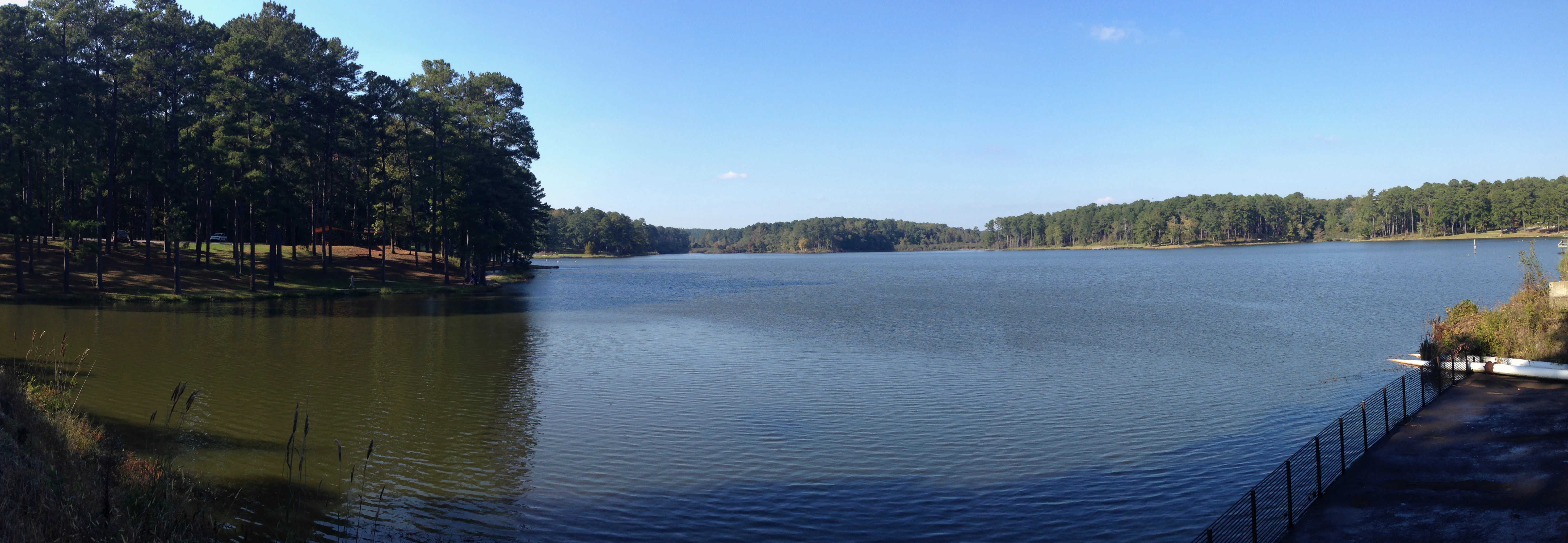
A wide view of a calm lake surrounded by dense pine forest under a clear blue sky.
A view of Choctaw Lake in Tombigbee National Forest, Mississippi.

Tombigbee National Forest history and protected-area timeline

Tombigbee National Forest was officially established on November 27, 1959, as part of the mid-twentieth-century effort to develop and conserve forested lands in the American South, particularly in Mississippi. The forest took its name from the Tombigbee River, a waterway of long historical importance to the region and to the Indigenous cultures that inhabited its valleys long before European settlement. Its creation reflected a federal push during the 1950s and 1960s to acquire, consolidate, and manage southern forestlands under consistent national policy.

In the decades before its federal designation, much of the same landscape was used for timber harvest, small-scale agriculture, and rural settlement. The formation of the national forest reorganised these uses into a managed landscape under the U.S. Forest Service, with the practical work of administration carried out from ranger district offices including the one in Ackerman. The forest remains embedded in a part of Mississippi with deep settlement-era roots, and its preservation has preserved a mix of working forest, recreation land, and culturally significant ground.

The pre-contact history of the land itself extends many centuries earlier. Within the forest boundary, the Owl Creek Mounds represent a sequence of five platform mounds constructed between approximately 1100 and 1200 CE by Indigenous peoples participating in the wider Woodland-period and Mississippian-era mound-building traditions of the eastern United States. These earthen monuments are among the older, durable cultural landmarks inside the modern national forest and remain a key reason the area is recognised as more than a purely natural reserve.

Tombigbee National Forest landscape and geographic character

The landscape of Tombigbee National Forest reflects the gentle, rolling terrain typical of east-central Mississippi. The southern section, the larger of the two, lies north of Louisville and spans parts of Winston, Choctaw, and Oktibbeha counties. This region is composed of mixed uplands dissected by small creeks that eventually drain toward the Tombigbee River system. Pine and hardwood stands drape the ridges and hollows, giving the area its characteristic forested character.

The smaller northern section lies in Chickasaw and Pontotoc counties northeast of Houston, in a similarly rural part of northeastern Mississippi. Altitudes are modest throughout the forest, and elevation changes are gradual rather than dramatic, producing a landscape that reads as continuous, low-relief country rather than rugged uplands. Small watercourses, bottomlands, and occasional cleared openings interrupt the otherwise heavily wooded terrain.

A particular landform feature of interest is Choctaw Lake, a managed impoundment in the southern section that adds an open-water element to the otherwise forested scenery. The lake's shoreline and surrounding woodlands give the southern unit much of its recognisable visual identity. Together, the two sections function as a mosaic of wooded uplands, creek valleys, and one prominent reservoired landscape, all shaped by long proximity to the Tombigbee watershed.

Tombigbee National Forest ecosystems, habitats, and plant life

Ecologically, Tombigbee National Forest lies within the southern mixed forest region of the eastern United States, an area where pine and hardwood species share dominance. Pine plantations and naturally regenerated pine stands are a recurring feature of the forest, alongside bottomland hardwood corridors along the small streams that drain toward the Tombigbee River. This combination of upland pine, mixed hardwood, and stream-bottom vegetation defines much of the forest's habitat structure.

Wetland and aquatic habitats are present in the form of small creeks, seeps, and the more substantial open-water setting of Choctaw Lake. These water features support characteristic southern aquatic vegetation and provide habitat for fish, amphibians, and water-associated birdlife. The mix of open water, shoreline vegetation, and adjacent upland forest creates a varied habitat gradient across the southern section.

Across both sections, the forest functions as a maintained landscape of working woodlands and conserved habitat, rather than a fully wilderness-style preserve. Active management of timber stands, openings, and recreation areas continues to influence the vegetation patterns, but the overall ecological character remains that of an east Mississippi forest dominated by pines, oaks and associated hardwoods, and crossed by small drainages heading toward the Tombigbee.

Tombigbee National Forest wildlife and species highlights

Wildlife in Tombigbee National Forest reflects the typical species mix of southern pine-hardwood landscapes and adjacent aquatic habitats. The forest supports common resident game species such as white-tailed deer, wild turkey, and various small mammals, alongside furbearers that use both upland and bottomland cover. Hunting is part of the established relationship between the forest and surrounding communities, with deer and turkey among the most actively pursued species.

Choctaw Lake and the surrounding riparian and wetland corridors add an important aquatic and semi-aquatic element to the forest's wildlife profile. These water-associated habitats support fish populations, amphibians, turtles, and waterbirds, while transitions between open water, shoreline vegetation, and upland forest create edge habitats that benefit a range of bird species typical of the southeastern United States.

The forest's combination of pines, hardwoods, and small water features also makes it useful habitat for a variety of songbirds and seasonally migrant birdlife. Raptors, wading birds, and common woodland songbirds can be expected across the two sections, especially around Choctaw Lake and along the smaller creek corridors. While Tombigbee is not marketed as a wildlife spectacle on the scale of larger western reserves, its species mix is consistent with the broader mosaic of central-east Mississippi's working and conserved forestlands.

Tombigbee National Forest conservation status and protection priorities

From a conservation perspective, Tombigbee National Forest plays a steady, durable role in protecting a large block of mixed pine-hardwood forest in a part of Mississippi that has historically experienced heavy timber use and active land conversion. By holding roughly 67,000 acres in federal stewardship, the forest helps maintain forest cover, watershed stability, and habitat continuity across multiple counties in east-central Mississippi.

The forest's conservation value is reinforced by its connection to the Tombigbee River watershed. Protecting upland and riparian forests in this drainage contributes to water quality, erosion control, and the long-term integrity of streams feeding one of the region's important rivers. This watershed-level role is one of the more practical conservation functions of the property.

In addition to its ecological role, the forest's conservation mandate extends to cultural heritage protection through the Owl Creek Mounds site. Preserving these pre-contact platform mounds within an actively managed national forest reflects a broader approach that treats the land as both a natural and a cultural resource. Together, the forest's habitat, watershed, and archaeological protections give it a multi-dimensional conservation character rather than simply that of a single-purpose timber or recreation reserve.

Tombigbee National Forest cultural meaning and human context

Cultural context for Tombigbee National Forest extends well beyond its 1959 establishment, reaching back to the Indigenous mound-building societies that shaped much of the southeastern landscape. The Owl Creek Mounds, a cluster of five platform mounds built between roughly 1100 and 1200 CE, are the most direct link between the forest and these older cultural traditions. They mark the forest as a landscape that carries centuries of human history into the present.

The surrounding region has deep roots in the broader history of Mississippi, including settlement-era timber use, agricultural development, and the rural community life that continues to define east-central Mississippi today. Communities like Louisville, Ackerman, and Houston sit close to the forest's two sections, and the national forest has long functioned as part of the surroundings in which these towns developed. This local relationship between forest and community forms an important part of the area's cultural identity.

Taking the forest's name from the Tombigbee River also gives the property a strong regional-cultural anchor. The Tombigbee is a waterway with deep historical resonance in the Deep South, and naming a national forest after it ties the protected landscape directly into the broader geographic and cultural heritage of the Tombigbee River country.

Top sights and standout views in Tombigbee National Forest

Tombigbee National Forest stands out for its two-unit geography in east Mississippi, with a larger southern section north of Louisville and a smaller northern section northeast of Houston. Choctaw Lake provides one of the most visible recreational anchors in the southern unit, and together the two sections define a working forest landscape shaped by the Tombigbee River watershed.

Equally distinctive is the presence of the Owl Creek Mounds, five pre-contact platform mounds built between approximately 1100 and 1200 CE, which place the forest within the wider Indigenous mound-building tradition of the southeastern United States. This combination of sizeable southern forest, river-named identity, and an embedded archaeological site gives Tombigbee National Forest a character that mixes natural resource, recreation area, and cultural heritage into a single federal property.

Best time to visit Tombigbee National Forest

Tombigbee National Forest is broadly accessible year-round within the typical pattern of southern U.S. National Forests, but the spring and fall seasons tend to bring more comfortable temperatures for hiking, picnicking, and general outdoor recreation across east-central Mississippi. Spring brings leaf-out and active woodland birdlife, while autumn colours in the hardwood component give the forest a noticeably warmer visual palette.

Summer in this part of Mississippi is hot and humid, and visitors during this period will most often be drawn to the forest's water features, particularly Choctaw Lake, and to shaded woodland trails. Winter is mild by national standards, and the open conditions can be favourable for hiking, wildlife observation, and quieter visits. Across all seasons, the forest's mix of pine and hardwood stands means that the experience shifts with foliage, water levels, and seasonal wildlife patterns rather than with dramatic climatic swings.

Monthly climate preview

Long-term average temperature and precipitation rhythm measured across the forest coordinates

Tombigbee National Forest Climate Normals and Monthly Weather Patterns

Tombigbee National Forest records a broad range of monthly mean temperatures alongside steady long-term precipitation values across the representative coordinate. Reviewing the complete twelve-month profile provides deeper context on historical temperature extremes and monthly precipitation distributions.
Annual mean17 °C
5 °C28 °C
Jan
Feb
Mar12°
Apr17°
May21°
Jun26°
Jul28°
Aug28°
Sep24°
Oct18°
Nov11°
Dec
Warmest month
July

27.9 °C

Coolest month
January

5 °C

Wettest month
February

4.9 mm/day

Driest month
September

3.1 mm/day

Park location guide

Geography guide, regional context, and park location map for Tombigbee National Forest

Tombigbee National Forest park geography, regions, and map view in United States of America

Understand where Tombigbee National Forest sits in United States of America through a broader geographic reading of the surrounding landscape, nearby location context, and its mapped position within the national park landscape.

How Tombigbee National Forest fits into United States of America

The United States of America is a federal presidential republic and one of the world's largest countries by area and population. It consists of 50 states across a vast territory spanning multiple time zones, with its capital in Washington, D.C. and largest city in New York City. The nation has a diverse economy, influential political system, and significant cultural and military presence globally.

Wider geography shaping Tombigbee National Forest in United States of America

The United States occupies a vast territory in North America, bordered by Canada to the north and Mexico to the south. The 48 contiguous states stretch from the Atlantic to the Pacific Ocean, while Alaska occupies the northwestern region and Hawaii is an archipelago in the Pacific. The country encompasses diverse terrain including the Rocky Mountains, Appalachian Mountains, Great Plains, and extensive river systems.

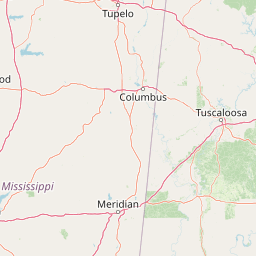
Map view of Tombigbee National Forest

Use this park location map to pinpoint Tombigbee National Forest in United States of America, understand its exact geographic position, and read its mapped placement within the surrounding landscape more clearly.

Pigeon | © OpenStreetMap contributors

Location context for Tombigbee National Forest

Mississippi
Recorded earthquake history

Explore Recorded Earthquake Activity Near Tombigbee National Forest

Examine the historical record of seismic events documented around Tombigbee National Forest. This catalogue provides direct access to event details, including magnitude and distance metrics, to help understand the regional seismic history of this Mississippi forest environment.

Tombigbee National Forest Earthquake History

Catalogued events

2 events

Strongest magnitude

Magnitude 3.4

Most recent event

May 10, 2008

This history includes earthquakes recorded inside the park or within 50 km of its borders

Visual reference collection highlighting pine woodlands, lake shorelines, and regional habitats

Tombigbee National Forest Photos, Landscapes, and Protected Area Scenery

Visual documentation captures the rolling pine woodlands, mixed hardwood stands, and quiet waterways that define the protected landscape. Examining field photography reveals the characteristic terrain of the dual forest units and the surrounding river watershed.

A wide view of a calm lake surrounded by dense pine forest under a clear blue sky.

Park atlas

Compare regional park geography and adjacent southern forest landscapes

Other Parks and Protected Areas Near Tombigbee National Forest

Browse nearby national forests and protected areas located throughout the surrounding region to compare regional terrain features. Extending the search helps reveal broader ecological patterns across adjacent southern woodland watersheds and low relief terrain.
Watercolor painting of a green landscape featuring rolling hills, small clusters of trees, and a calm water feature in the foreground.
Protected landscapeMississippi
41 km away#1 closest

North

Holly Springs National Forest: Geographic Context and Protected Landscape Boundaries

Northern Mississippi forest topography and ecological restoration geography.

Holly Springs National Forest occupies the rolling hills of north central Mississippi, where federal land tracts form a complex mosaic with private holdings. This protected area features diverse forest types including loblolly and shortleaf pine uplands alongside bottomland hardwood swamps. It serves as an essential watershed region, hosting multiple reservoirs like Chewalla Lake and Puskus Lake while protecting the headwaters of the Wolf River.

Area
629.94 km²
Established
1936
Relief
Upland
Climate
Subtropical
Protected landscapeAlabama
112 km away#2 closest

East

William B. Bankhead National Forest: Cumberland Plateau Landscapes and Geography

Protected river gorges and forested ridges in northwestern Alabama

Covering extensive tracts across Lawrence, Winston, and Franklin counties, William B. Bankhead National Forest anchors the regional geography of the Cumberland Plateau. This atlas entry provides a detailed look at the forest's stream-carved terrain, limestone geology, and its central role in preserving the riparian corridors of the Sipsey Fork and its surrounding protected wilderness.

Area
733.4 km²
Established
1918
Relief
Upland
Scope
Terrestrial
Protected landscapeMississippi
213 km away#3 closest

Southwest

Homochitto National Forest: Mapping the Protected Landscapes of Southwestern Mississippi

Regional forest geography and landscape documentation.

Investigate the unique landscape of Homochitto National Forest, an extensive protected area in Mississippi defined by its loess-country topography and managed pine forests. This entry provides essential mapping context and geographic data for those examining the role of this forest within the broader Southeastern United States ecological network and its CCC-rooted heritage.

Area
776.34 km²
Established
1936
Relief
Upland
Scope
Terrestrial
Protected landscapeAlabama
About 227 km away#4 closest

East

Talladega National Forest: Geography and Protected Appalachian Forest Maps

Mapping Alabama high country and southern Appalachian forest recovery

Talladega National Forest is a primary protected landscape in Alabama, offering a detailed look at the transition from central pine-oak ridges to northeastern mixed mesophytic hardwood slopes. This forest manages a diverse range of terrain, including the highest peaks in the state, and represents a major achievement in regional ecological restoration across hundreds of thousands of acres of federally protected land.

Area
1,588.66 km²
Established
1936
Relief
Mixed relief
Climate
Temperate
A watercolor painting showing a stylized landscape with rolling green hills, a band of trees, and a pale pink lake surface under a soft morning sky.
Protected landscapeUnited States of America
273 km away#5 closest

North

Land Between the Lakes National Recreation Area: Mapped Geography and Protected Landscapes

An inland peninsula preserved between two major river reservoirs.

Land Between the Lakes National Recreation Area occupies a distinct narrow land bridge between Kentucky Lake and Lake Barkley. This protected landscape contains a dense mix of forested ridges, stream valleys, and managed wildlife prairies. The area is integral to the lower Ohio River Valley geography, showcasing the results of long-term watershed management and large-scale ecological restoration within the United States.

Area
693.1 km²
Established
1963
Visitors
2M annual
Relief
Lowland
Watercolor painting of a mountain landscape with soft layers of green hills, trees, and a foreground area, rendered in a pale and minimalist style.
Wildlife reserveAlabama
295 km away#6 closest

East

Dugger Mountain Wilderness: Mapping Alabama's Appalachian Ridge and Forest Landscapes

Protected mountain terrain and regional Appalachian geography

Dugger Mountain Wilderness acts as a primary anchor for ecological preservation in Alabama. This wildlife reserve preserves over 9,000 acres of steep, roadless ridges near the Appalachian margin. By studying the topographic boundaries and forest cover of this area, observers can better understand the regional mountain characteristics and the critical role this terrain plays in maintaining intact, uninterrupted natural corridors.

Area
37 km²
Established
2000
IUCN
Ib
Relief
Mountain
A watercolor illustration of a coastal landscape with a sandy shoreline, soft green dunes, and a gentle pink horizon against a white background.
Protected landscapeFlorida
307 km away#7 closest

Southeast

Gulf Islands National Seashore: Mapped Landscapes and Protected Coastal Geography

Coastal terrain across Florida, Alabama, and Mississippi.

Spanning diverse units across the Gulf Coast, Gulf Islands National Seashore preserves dynamic barrier islands and mainland reserves. This geographic profile traces the quartz-sand beaches, maritime ecosystems, and historic defense networks that form this protected landscape, providing context on its unique geologic and environmental evolution.

Area
548.179 km²
Established
1971
IUCN
V
Visitors
8.3M annual
A horizontal watercolor painting depicting a flat, green coastal marsh with distant purple hills under a pale sky.
Wildlife reserveMississippi
About 315 km away#8 closest

South

Grand Bay National Estuarine Research Reserve: Mississippi Coastal Protected Area Geography

Mapping estuarine ecosystems and coastal forest mosaics

Focusing on the interface between the Mississippi Sound and terrestrial habitats, this reserve protects a vital expanse of estuarine waters, oyster reefs, and pine savanna. Its geography highlights the dynamic interaction of tidal channels, shoreline erosion, and fire-dependent ecosystems within the broader Gulf of Mexico coastal region.

Area
74 km²
Established
1999
IUCN
IV
Relief
Lowland

Common questions about visiting, size, designation, and location context for Tombigbee National Forest

Tombigbee National Forest FAQs for park facts, access, geography, and protected area context

Find quick answers about Tombigbee National Forest, including protected-area facts, park geography, trail and visitor context, and how the park fits into its surrounding country and regional landscape.
MoriAtlas Explorer

Continue Your Protected Areas Search Across the Global Atlas

Deepen your exploration by continuing the structured search for national parks and protected areas worldwide. Utilize the comprehensive filtering capabilities to compare different conservation landscapes and refine your understanding of global park geography. Discover more about the distribution and characteristics of protected natural areas.

Global natural geography