
Mori Atlas logo
Nature reserveTöpchiner Seen

Understanding the interplay of post-glacial lake basins, peat-forming mires, and sandy forest ecosystems

Töpchiner Seen Nature Reserve: A Detailed Atlas of Glacial Wetlands and Mapped Protected Landscapes in Brandenburg

(Naturschutzgebiet Töpchiner Seen)

Töpchiner Seen represents a significant nature reserve in the Brandenburg region, encompassing roughly 375 hectares of complex wetland habitats. The area serves as a primary example of glacial meltwater drainage systems, defined by the pairing of the Obere and Untere Töpchiner See lakes. Its landscape mosaic integrates lowland fens, calcareous wet meadows, and dry pine woodlands, illustrating the distinct ecological transition between waterlogged peat basins and well-drained sandy ridges shaped by the last ice age.

nature reservewetlandslowland fenscalcareous fenstransition mireswet meadows
Digital illustration of a scenic valley with a river, surrounding forests, and a lookout tower on a high cliff under a soft sun.

Töpchiner Seen

Nature reserve

Park overview

Structured park overview, official facts, and landscape profile for Töpchiner Seen

Töpchiner Seen park facts, protected area profile, and essential visitor context

Review the core facts for Töpchiner Seen, including designation, size, terrain, visitor scale, habitats, and operating context in one park-focused overview.

About Töpchiner Seen

The Töpchiner Seen nature reserve occupies a low-relief basin in the rolling countryside of southern Brandenburg, about ten kilometres south-south-east of the centre of Mittenwalde and just south of the larger Motzener See. Although the lakes themselves are small, they sit at the heart of a much richer mosaic of habitats shaped by ice-age meltwater and by centuries of changing water levels. Today, roughly 375 hectares of open water, mire, wet meadow, dry sand grassland, and old oak and pine woodland are protected together as a single reserve, and the entire protected area also has the status of a European Habitats Directive (FFH) site, reflecting its cross-border ecological significance.

What makes the reserve notable is the contrast that fits into a small area. Around the two lakes, the land has been waterlogged for so long that peat has built up to depths of five to eight metres in places, producing transition mires, calcareous fens, and floating mats of vegetation rich in cottongrass, marsh marigold, and bogbean. Away from the mires, slightly higher ground carries dry sand grasslands with rarities such as spiked speedwell and corn cleavers, while pockets of 170-year-old pedunculate oaks and lichen-rich pine forest provide a wooded counterpoint. A roughly nine-kilometre circular trail links these landscapes, crossing both the European long-distance path E10 and the Fontane Way F4.

The reserve is equally interesting as a story of human intervention and recovery. A 12th-century mill at Motzen, 19th-century drainage works by the Notte regulatory authority, and 20th-century fish farming all reshaped the lakes. Since protection was granted in 1988, efforts have focused on stabilising water levels, restoring natural outflow patterns with dams and weirs, and using low-intensity grazing by cattle and water buffalo to keep the open mire vegetation from being overgrown. Swimming, boating, and sailing are not permitted, but angling with a permit is allowed in the northern Töpchiner See, reflecting the balance between conservation and carefully limited use.

Quick facts and research context for Töpchiner Seen

The Töpchiner Seen is a designated nature reserve (Naturschutzgebiet) in Brandenburg, Germany, lying mainly within the municipal area of Mittenwalde and partly in Groß Köris. It covers approximately 375 hectares and has been protected by legal order since 29 May 1988, and is co-extensive with an EU Habitats Directive (FFH) site of the same name. The reserve sits within the broader Notte-Niederung landscape protection area and belongs to the natural region of the eastern Brandenburg heath and lake district.

The site's core features are two lakes connected by a ditch that drain into the Motzener See, surrounded by extensive peat-forming fens, transition mires, calcareous wet meadows, dry sand grasslands, old oak woodland, mire forests, and lichen-rich pine forest. Its ecological interest is shaped by the unusual combination of nutrient-rich lakes, deep peat deposits up to roughly eight metres thick, and a maintained mosaic of open and lightly wooded habitats used by breeding waders and wetland birds.

Protection and recognition

Documented Natura 2000 listings and official protected area records

Töpchiner Seen Protection Status and International Recognition Data

Töpchiner Seen maintains recorded protection status through official Natura 2000 designations and baseline database identifiers. Conservation records outline the administrative framework supporting regional ecological preservation and habitat management.
Park context

Deeper park guide and search-rich context for Töpchiner Seen

Töpchiner Seen history, landscape, wildlife, and travel context

Explore Töpchiner Seen through its history, landscape character, ecosystems, wildlife, conservation priorities, cultural context, and seasonal travel timing in a structured park guide built for atlas discovery and search intent.

Why Töpchiner Seen stands out

The reserve is best known for its close pairing of two small post-glacial lakes with a ring of peat-forming lowland mires and wet meadows that grew up around them after the last ice age. Particularly distinctive are the calcareous fens, the transition and quaking mires, the extensive reedbeds and carr woodland, and the dry sand grasslands that occur together within a compact, well-protected area. It is also recognised for the inhabitants of these habitats: a rich assemblage of dragonflies and grasshoppers on the open fens and dry grassland, breeding populations of wetland and heathland birds such as snipe, spotted crake, common crane, hoopoe, woodlark, and stonechat, and populations of protected species including the great copper butterfly and the Eurasian otter.
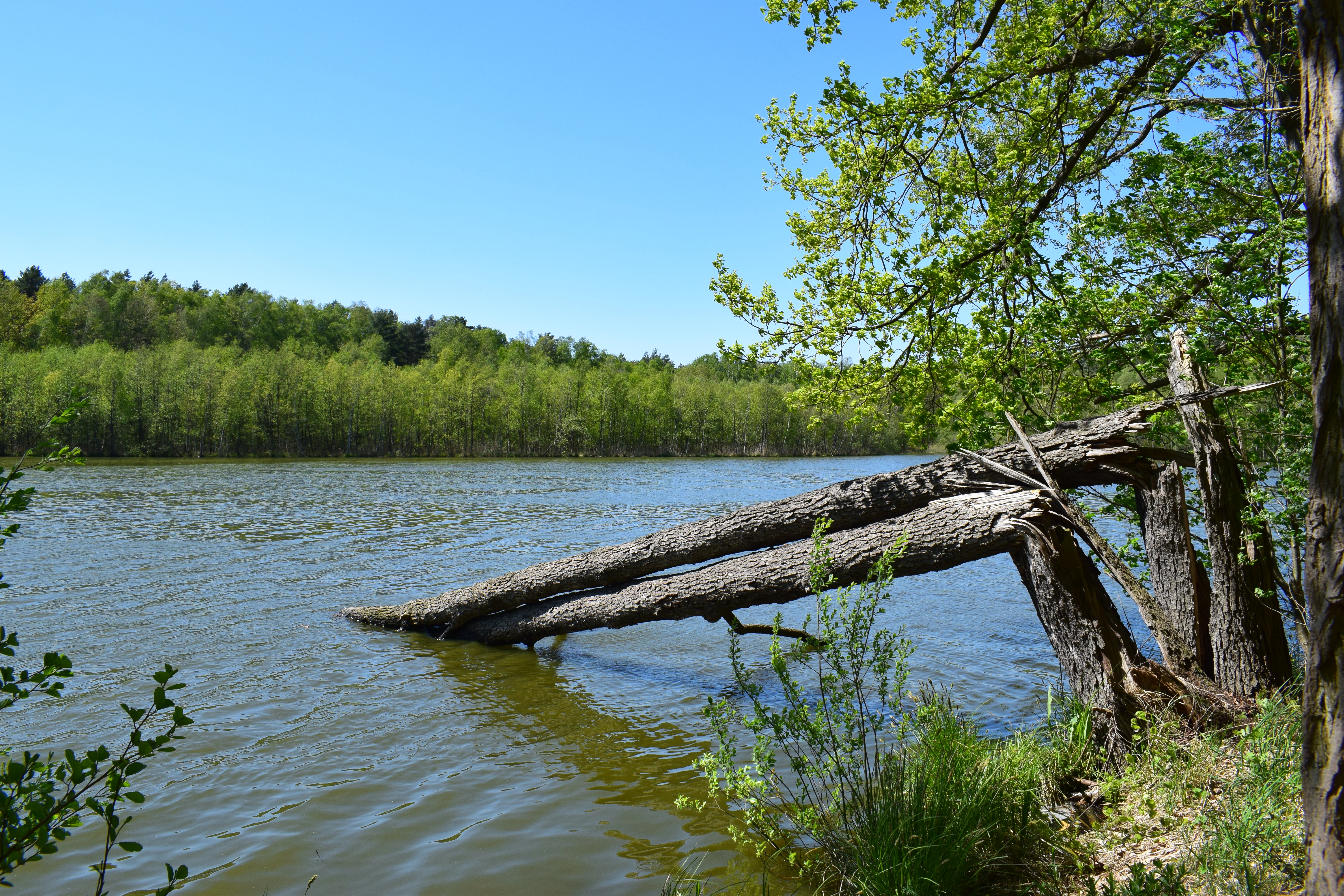
A fallen tree trunk extends into the water of a calm lake, with lush green trees lining the distant shore under a clear blue sky.
A view of the Töpchiner Untersee at the Töpchiner Seen nature reserve in Brandenburg.

Töpchiner Seen history and protected-area timeline

The landscape of the Töpchiner Seen originated during the last ice age, the Weichselian glaciation, when meltwater carved drainage channels across what is now southern Brandenburg. As the ice retreated, water-filled basins were left behind, and over thousands of years these gradually silted up and developed into fens and bogs. Originally the meltwater drained southward, but over time the flow reversed, and peat began to accumulate across what is now the reserve, reaching thicknesses of around five metres, and up to eight metres locally, across large portions of the area.

Human influence has shaped the wetlands for centuries. As early as the 12th century, residents of nearby Motzen are believed to have built a watermill that required damming the local water, and the hydrology of the area remained closely bound up with human activity. A more decisive change came in 1862, when the Notte regulatory authority lowered the water level by roughly 1.3 to 1.4 metres, triggering large-scale peat formation and the gradual separation of one lake into the two bodies now known as the Obere and Untere Töpchiner See. In the 1970s and 1980s, intensive fish farming enriched the lakes with nutrients, turning them into polytrophic water bodies with heavy phytoplankton blooms in summer.

On 29 May 1988 the area was placed under legal protection as a nature reserve, the same year as more recent regulatory updates that have maintained its status. Since then, water-management work in the 2010s has aimed to stabilise the previously fluctuating water regime of the mires, including the installation of plugs along the Töpchiner Hauptgraben and the construction of bed sills to restore more natural outflow patterns.

Töpchiner Seen landscape and geographic character

The reserve sits in the Ostbrandenburgisches Heide- und Seengebiet natural region, specifically within the Zossen-Teupitzer Platten- und Hügelland sub-unit, a gently undulating terrain of glacial deposits. Its surface is shaped by subtle reliefs: low morainic rises to the south and south-east, and a low-lying central corridor in which the lakes, ditches, and mires have developed. This terrain gives the protected area a layered character, with dry, sandy ridges standing only a short distance from waterlogged depressions.

The two Töpchiner Seen are the visual centrepiece of the reserve. The Obere Töpchiner See to the south and the Untere Töpchiner See to the north are connected by the meandering Töpchiner Hauptgraben, an artificial but ecologically important ditch that channels water downstream into the Motzener See. Around both lakes, broad belts of reeds, marshland, and gradually encroaching carr woodland frame the water.

Beyond the lakes and mires, the landscape also contains drier elements. Small raised areas to the south and south-east of the upper lake carry old oak stands and pine woodland, and fragments of dry grassland where the sandy soil is too well-drained for peat to form. A roughly nine-kilometre circular trail makes it possible to experience this sequence of waterlogged and dry landscapes within a single walk, moving from open reedbeds and floating mires through wet meadows to pine and oak forest on slightly higher ground.
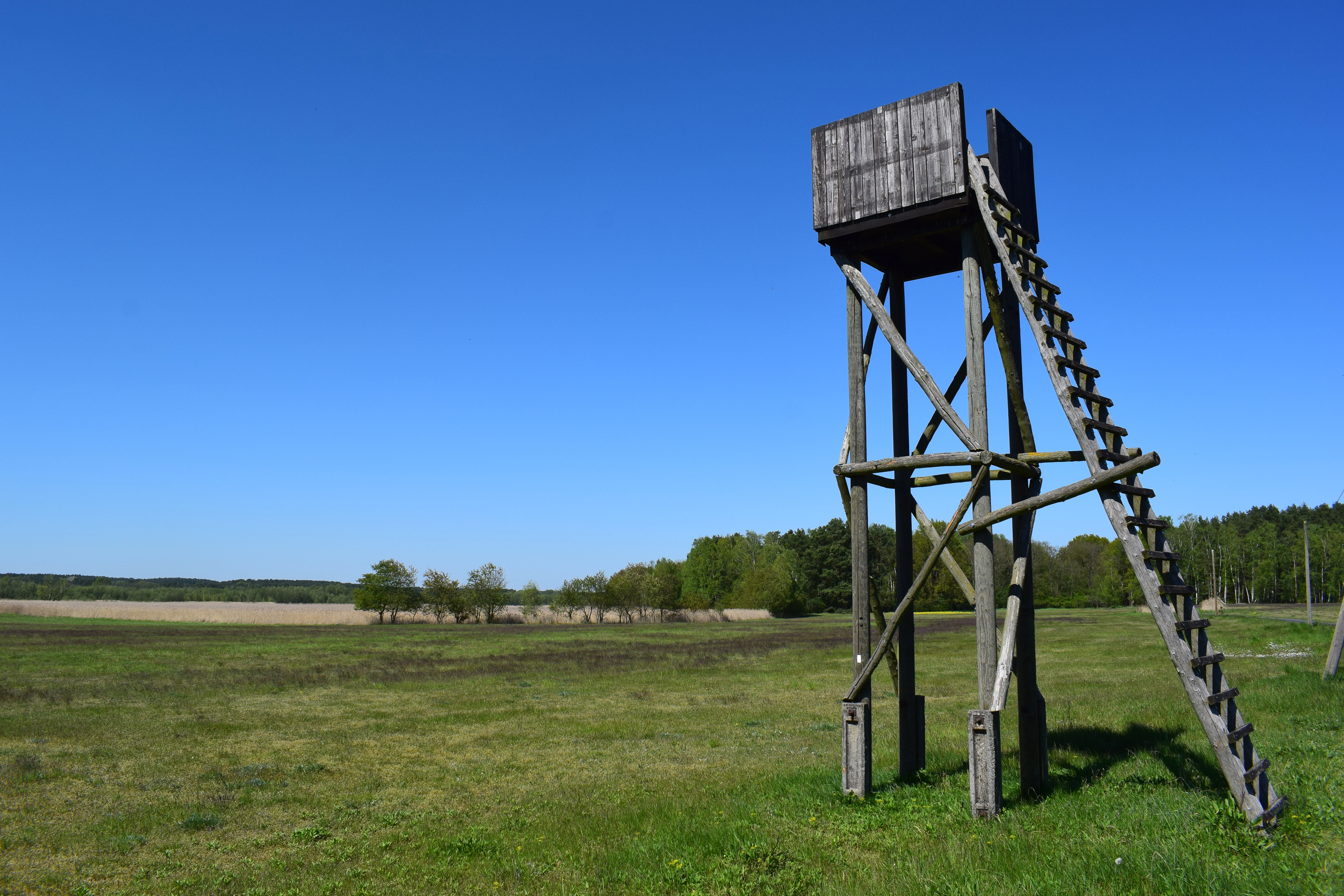
A weathered wooden observation tower stands in a grassy field under a clear blue sky, with a treeline visible in the distance.
A wooden wildlife observation tower situated in the open grassland of the Topchiner Seen nature reserve.

Töpchiner Seen ecosystems, habitats, and plant life

Ecologically, the reserve is best understood as a tightly packed mosaic of contrasting habitats, set out by the European Habitats Directive as nine different Annex I habitat types. These include naturally eutrophic lakes with pondweed and frogbit vegetation, dry calcareous sand grasslands, Molinia meadows on calcareous soils, mesotrophic hay meadows, transition and quaking mires, calcareous fens, old acidophilous oak woods on sandy plains, mire forests, and Central European lichen-rich pine woods. The variety within a relatively small area is one of the reserve's defining features.

The lakes themselves have very little underwater vegetation, and in summer the water clouds with phytoplankton, reducing visibility to less than forty centimetres. Around their margins, however, the flora is rich: water-cress in the shallows, floating-leaved plants, reeds of common reed and cattail, and stretches of wet woodland dominated by alder, birch, and willow. The fens themselves are biologically active peat-forming systems; floating mats around the lakes are dominated by bogbean and marsh horsetail, and the wetter ground also supports fen orchids, marsh cinquefoil, narrow-leaved cottongrass, and a range of sedges.

On drier ground, dry sand grassland communities, some developed on former arable land, host silvery hairgrass and a suite of rarer plants including spiked speedwell, brown plumeless cornflower, red cinquefoil, and corn cleavers. Old stands of pedunculate oak, with trees over 170 years old, line the higher parts of the southern and south-eastern reserve, accompanied by a lichen-rich pine forest community on the most acidic soils. Together, these habitats support an unusually wide range of flora across the same compact site.

Töpchiner Seen wildlife and species highlights

The Töpchiner Seen is particularly valued for its invertebrates, especially on the open mire and dry-grassland habitats. Two Annex II species under the Habitats Directive are specifically associated with the reserve: the great copper butterfly, which inhabits the damper meadows, and the Eurasian otter, which uses the lakes, ditches, and connecting waterways. Other notable insects include the diminutive damselfly, the six-spot burnet moth, and a very rich grasshopper fauna, with marshland specialists such as the large marsh grasshopper and short-winged bush-cricket on the fens, and dry-ground species such as the wart-biter, western bush-cricket, and red-legged grasshopper on the sand grasslands.

The reserve is also meaningful for breeding and visiting birds. Open-country nesters include hoopoe, woodlark, stonechat, tawny pipit, and barred warbler, while the wetter sections support characteristic wetland species such as snipe, spotted crake, and common crane. Kingfishers breed along suitable stretches of the Töpchiner Hauptgraben where it offers steep, undisturbed banks. The insect-rich habitats of the reserve provide abundant food for many of these birds during the breeding season.

Fish remain present in the lakes despite nutrient enrichment, and typical species include European eel, pikeperch, perch, northern pike, common carp, roach, and wels catfish. The combination of invertebrates, fish, birds, and mammals reflects the way in which the reserve's small size still supports an unusually broad community of wildlife.

Töpchiner Seen conservation status and protection priorities

The Töpchiner Seen is one of the older and more formally recognised nature reserves in Brandenburg, having been placed under legal protection on 29 May 1988, and is, in fact, co-extensive with an EU Habitats Directive site of the same name, ensuring both national and European-level conservation commitments. Conservation interest focuses on the long-term survival of the lake-and-mire complex, particularly the calcareous fens, transition mires, and wet meadows that take many centuries to form and that are easily damaged by changes in water regime.

Key conservation challenges include managing the nutrient loading left over from the 1970s and 1980s, which still affects the lakes, and stabilising the variable water levels of the surrounding mires. Recent water-engineering work, including plugs in the Töpchiner Hauptgraben and bed sills below the lakes, has aimed to re-establish more natural outflow conditions.

The reserve is also at the forefront of low-intensity, ecologically oriented management. In cooperation with a local farm, the Brandenburg state's NaturSchutzFonds foundation has introduced water buffalo into the wetland margins to graze selectively, helping to keep moor vegetation from being out-competed by other plants and maintaining the open character of the fens and moist meadows that so many of the reserve's species depend on.

Töpchiner Seen cultural meaning and human context

Although the reserve is primarily a natural area, its landscape carries a strong human imprint, the result of centuries of water management and land use. The early mill at Motzen, dating back to the 12th century, marks the beginning of deliberate intervention in the hydrology of the area and shows how closely local communities have been tied to the water system for generations. The 19th-century lowering of the lake levels by the Notte regulatory authority in 1862 was a major collective engineering effort with lasting consequences for the land.

Modern cultural engagement with the reserve is more about stewardship than exploitation. The use of water buffalo and cattle for grazing reflects a deliberate choice to combine traditional pastoral land use with conservation objectives, and is supported by the state-supported NaturSchutzFonds foundation. Visitors encounter this mix of nature and culture along the roughly nine-kilometre circular trail, which crosses both the European long-distance path E10 and the Fontane Way F4, placing the landscape in a wider regional context of walking routes that link protected areas and places of literary significance across Brandenburg.

Top sights and standout views in Töpchiner Seen

Among the most distinctive features of the Töpchiner Seen are the two small lakes themselves and the unusually deep peat blanket that surrounds them, built up over thousands of years from the moment the last glaciers retreated. Within a compact area, visitors can pass from open water, through broad reedbeds and floating mire, into calcareous fens and hay meadows, and then on to old oak stands and lichen-rich pine forest, experiencing almost the full range of the reserve's habitat mosaic in a single walk.

Equally distinctive is the reserve's biodiversity concentration: a small site that nonetheless supports Annex II species such as the great copper butterfly and the otter, breeding populations of hoopoe, woodlark, stonechat, snipe, common crane, and kingfisher, and an exceptionally rich grasshopper and dragonfly fauna. The combination of formal nature reserve status, its status as an EU Habitats Directive site, and ongoing active management through low-intensity grazing makes it a strong example of integrated wetland conservation in Brandenburg.

Best time to visit Töpchiner Seen

Late spring through early autumn is the most rewarding time to visit the Töpchiner Seen, when the lakes, mires, and meadows are biologically most active. In late spring and early summer, dry sand grasslands come into flower and grasshoppers, damselflies, and butterflies are most numerous, while June and July bring the loudest breeding season for reedbed and open-country birds such as common crane, snipe, hoopoe, and woodlark.

Late summer tends to coincide with stronger phytoplankton blooms in the lakes themselves, a reflection of their nutrient-rich status, and autumn draws migrating waterbirds and increases the visual contrast between the still-green wet meadows, the reddening reeds, and the golden colours of the surrounding oak and pine stands. In winter the reserve is quieter, but the open mires and the lake shorelines remain accessible along the circular trail, and the calmer pace and bare trees make the layered structure of the landscape easier to appreciate.

Monthly climate preview

Track monthly average temperatures and precipitation cycles across representative terrain in Brandenburg.

Töpchiner Seen Climate Normals, Long-Term Temperature and Precipitation Patterns

Long-term data records for Töpchiner Seen establish a measured annual temperature range from negative winter minimums to warm summer maximums alongside steady daily precipitation rates. Examining the full monthly climate profile reveals detailed shifts in temperature and moisture distributions across the protected landscape.
Annual mean10 °C
-1 °C21 °C
Jan-1°
Feb
Mar
Apr
May14°
Jun18°
Jul21°
Aug20°
Sep15°
Oct
Nov
Dec
Warmest month
July

20.6 °C

Coolest month
January

-0.8 °C

Wettest month
July

2.5 mm/day

Driest month
April

1.1 mm/day

Park location guide

Geography guide, regional context, and park location map for Töpchiner Seen

Töpchiner Seen park geography, regions, and map view in Germany

Understand where Töpchiner Seen sits in Germany through a broader geographic reading of the surrounding landscape, nearby location context, and its mapped position within the national park landscape.

How Töpchiner Seen fits into Germany

Germany is a federal republic in Western and Central Europe with a population of over 83 million across sixteen constituent states. It is Europe's largest economy by nominal GDP and a major global exporter and importer. The capital is Berlin, and the country borders Denmark, Poland, Czech Republic, Austria, Switzerland, France, Luxembourg, Belgium, and the Netherlands.

Wider geography shaping Töpchiner Seen in Germany

Germany is located in Western and Central Europe, spanning 357,022 km². It borders Denmark to the north, Poland and the Czech Republic to the east, Austria and Switzerland to the south, and France, Luxembourg, Belgium, and the Netherlands to the west. The country has coastlines on the Baltic Sea and North Sea to the north, with the Alps located in the southern region.

Map view of Töpchiner Seen

Use this park location map to pinpoint Töpchiner Seen in Germany, understand its exact geographic position, and read its mapped placement within the surrounding landscape more clearly.

Pigeon | © OpenStreetMap contributors

Location context for Töpchiner Seen

Brandenburg

Visualizing post-glacial lakes, lowland fens, and wetland habitats

Töpchiner Seen Landscape and Scenery Photography

Photographic views reveal the glacial terrain, shallow lakes, and diverse mire habitats that define the protected landscape. Visual documentation helps observers examine the interplay of open water, reedbeds, and dry woodland across the reserve.

A fallen tree trunk extends into the water of a calm lake, with lush green trees lining the distant shore under a clear blue sky.

A canal flows through a dense, green wetland forest with many thin tree trunks and reflective water.

A weathered wooden observation tower stands in a grassy field under a clear blue sky, with a treeline visible in the distance.

Park atlas

Compare adjacent wetland reserves and regional glacial terrain across Brandenburg

Explore Parks Near Töpchiner Seen and Surrounding Protected Landscapes

Continue geographic discovery by comparing other protected areas near Töpchiner Seen with similar glacial lake habitats. Browse connected regional reserves to understand broader wetland conservation patterns across the surrounding terrain.
A horizontal watercolor painting showing a soft, fading line of forest trees, including conifers and yellow-leaved deciduous trees against a plain white background.
Nature reserveBrandenburg
2.2 km away#1 closest

Southwest

Kleine und Mittelleber Nature Reserve: Brandenburg Wetland and Mire Landscape Mapping

Ecological terrain analysis of a protected post-glacial site

Kleine und Mittelleber is a significant nature reserve in Brandenburg that preserves a rare sequence of silted-up lake basins and active peat-forming bogs. The area provides a detailed window into the interplay of transitional mire systems, floating mat bogs, and pine-fringed woodlands. Through its status as a European FFH site, it serves as a vital case study for the conservation of wetland habitats and the restoration of natural hydrological processes in post-industrial forest landscapes.

Area
0.665 km²
Established
1995
Nature reserveBrandenburg
4.1 km away#2 closest

Southeast

Naturschutzgebiet Löptener Fenne, Wustrickwiesen: Mapped Geography and Protected Landscapes

Glacial mire and wetland systems in Brandenburg, Germany

The Naturschutzgebiet Löptener Fenne, Wustrickwiesen nature reserve provides a critical look at terrestrialized mire landscapes. Beneath its surface lie deep layers of lake-derived mud, marking this site as a key reference for understanding glacial meltwater history in eastern Germany. Today, the area serves as a focal point for active peatland renaturation and habitat management within the Dahme-Spreewald district.

Area
2.18 km²
Established
1998
IUCN
IV
Relief
Lowland
A wide panoramic watercolor illustration showing a lake landscape with green trees and a soft pink and yellow sky.
Nature reserveBrandenburg
4.7 km away#3 closest

South

Briesensee und Klingeberg Nature Reserve: Mapped Landscapes and Glacial Terrain in Brandenburg

Protected glacial lakes and old-growth forest geography

Situated in the Dahme-Spreewald district, Briesensee und Klingeberg stands as a testament to Brandenburg's glacial past. The reserve protects complex aquatic and forest ecosystems, including genetically documented pine stands over 220 years old and the active Klingespring seepage site. Learn about the interaction between sandy moraine ridges and water-retaining depressions that sustain these rare mire and spring habitats within the German Natura 2000 network.

Area
0.799 km²
Established
2002
IUCN
IV
Nature reserveBrandenburg
6.8 km away#4 closest

East

Stintgraben Nature Reserve: Protected Stream Landscapes in Southern Brandenburg

Ecological connectivity between glacial lakes and river corridors.

Located in the Dahme-Spreewald district, Stintgraben is a protected stream corridor defined by its lowland riparian habitats and position between the Klein Köriser See and the Dahme river. This nature reserve provides essential ecological continuity within the broader Dahme-Heideseen region, offering a clear example of how small-scale protected areas maintain the natural integrity of Germany's glacial lake districts.

Area
1.09 km²
Established
1995
IUCN
IV
Nature reserveBrandenburg
8.6 km away#5 closest

East

Katzenberge Nature Reserve: An Atlas of Glacial Moraine Woodlands in Brandenburg Germany

Protected oak forest habitats within the Dahme-Spreewald landscape

Katzenberge offers a focused look at the conservation of mature deciduous forest environments on sandy moraine soils. As a designated nature reserve within the Brandenburg region, the area serves as a primary reference point for studying habitat continuity and the unique glacial terrain that defines the south-eastern lowlands near the Dahme river.

Area
1.44 km²
Established
2004
IUCN
IV
Relief
Upland
A watercolor painting showing a horizontal landscape of green trees and reflected water against a light, misty background.
Nature reserveBrandenburg
10 km away#6 closest

Southwest

Schöbendorfer Busch Nature Reserve: Mapped Protected Geography in Brandenburg

Lowland deciduous forest and glacial valley landscape.

Schöbendorfer Busch provides a window into the natural heritage of the Baruther Urstromtal. This nature reserve protects over 800 hectares of forest and agricultural mosaic, serving as a primary habitat for rare saproxylic beetles and bats. Its terrain, defined by glacial meltwater deposits and wet alder swamp environments, offers a distinctive example of Brandenburg forest conservation.

Area
8.31 km²
Established
1978
IUCN
IV
Nature reserveBrandenburg
10 km away#7 closest

North

Tiergarten Nature Reserve: Geography and Protected Habitat Mapping in Brandenburg, Germany

Ancient oak woodland, riparian wetlands, and historic forest trails.

Spanning 158 hectares, the Tiergarten nature reserve serves as an ecologically rich sanctuary of oak-hornbeam forests and wet meadows. This area, formerly a royal hunting ground, offers a dense mosaic of riparian zones along the Staabe river, protecting essential habitats within the broader Brandenburg landscape.

Area
1.58 km²
Established
1995
IUCN
IV
Nature reserveBrandenburg
11 km away#8 closest

Northeast

Dolgensee Nature Reserve: Mapped Protected Landscapes and Wetland Geography in Brandenburg, Germany

Protected lake basin, reedbeds, and inland dune grassland

Located in the Brandenburg state of Germany, Dolgensee Nature Reserve offers a rare mosaic of wetland and dry grassland habitats. The site centers on a nutrient-rich lake basin featuring extensive reedbeds and alder swamp, which transitions into open inland dune ecosystems. This protected area represents a significant example of natural lake basin preservation within the larger Dahme-Heideseen landscape, providing a crucial habitat for various waterbird and aquatic wildlife species.

Area
3.085 km²
Established
1995
IUCN
IV
Relief
Lowland

Common questions about visiting, size, designation, and location context for Töpchiner Seen

Töpchiner Seen FAQs for park facts, access, geography, and protected area context

Find quick answers about Töpchiner Seen, including protected-area facts, park geography, trail and visitor context, and how the park fits into its surrounding country and regional landscape.
MoriAtlas Explorer

Continue Your Protected Areas Search Across the Global Atlas

Deepen your exploration by continuing the structured search for national parks and protected areas worldwide. Utilize the comprehensive filtering capabilities to compare different conservation landscapes and refine your understanding of global park geography. Discover more about the distribution and characteristics of protected natural areas.

Global natural geography