
Mori Atlas logo
Nature reserveRéserve naturelle régionale de la tourbière de Logné

A rare lowland raised bog ecosystem in the Erdre valley, near the Nantes metropolitan area

Réserve naturelle régionale de la tourbière de Logné: Protected Bog and Peatland Geography

Réserve naturelle régionale de la tourbière de Logné stands as a significant botanical landmark in western France, preserving one of the southernmost lowland raised bogs in Europe. Located within the Pays de la Loire region, this protected area features a distinct basin landscape characterized by sphagnum moss cushions, bog woodland, and open water features. As a site of major ecological restoration, the geography showcases a rare relict habitat that serves as a vital refuge for invertebrate communities, northern plant species, and the European otter.

peatlandraised bogsphagnum bogwetlandsregional nature reserveLoire-Atlantique
A flat-design, colorful illustration of a park scene featuring a wooden boardwalk leading toward a small river, a waterfall in the background, surrounded by trees, cliffs, and wetland reeds.

Réserve naturelle régionale de la tourbière de Logné

Nature reserve

Park overview

Structured park overview, official facts, and landscape profile for Logné Bog Regional Nature Reserve

Logné Bog Regional Nature Reserve park facts, protected area profile, and essential visitor context

Review the core facts for Logné Bog Regional Nature Reserve, including designation, size, terrain, visitor scale, habitats, and operating context in one park-focused overview.

About Logné Bog Regional Nature Reserve

The Logné Bog Regional Nature Reserve lies at the northern edge of the Nantes metropolitan area, within the commune boundaries of Carquefou and Sucé-sur-Erdre. It is part of the Erdre marshes, occupying a depression on the left bank of the river that has filled with organic deposits over millennia. Although close to a major urban center, the reserve preserves a surprisingly wild and untouched landscape dominated by open peatland, bog woodland, and small watercourses.

The reserve's defining feature is its raised sphagnum bog. Peat accumulation here began more than 4,000 years ago, originally in a hollow formed by subsidence in the local micaschiste bedrock. Pliocene marine sands deposited in the basin act as a sponge, retaining water and feeding the peat-forming system. Over time, sphagnum mosses took hold, creating a topogenous to soligenous peatland conditioned by nutrient-poor conditions across the catchment. The bog's trembling surface and acidic, waterlogged conditions produce a distinctive microclimate, visibly cooler and more humid than the surrounding valley.

A basin of roughly 1,200 hectares surrounds the reserve, drained by several small streams and ditches that define the broader hydrology. The reserve itself functions within a network of regional wetlands, ecologically connected to Brière, Lac de Grand-Lieu, and the Loire estuary. This connectivity matters for migratory birds, amphibians, and mammals such as the European otter, which now frequents the bog's old extraction pits with regularity.

Beyond its physical setting, the reserve is a recognized biodiversity hotspot. Surveys have documented well over 200 vascular plant species (including 11 protected taxa), 47 mosses and liverworts, and 20 sphagnum species. The invertebrate fauna is equally remarkable, with hundreds of recorded beetle, spider, and moth species, alongside significant reptile and amphibian communities in an unusually small area. The reserve is not open for casual visits; access is restricted to a small number of guided excursions organized by Bretagne Vivante each year, making the site primarily a conservation, monitoring, and educational destination rather than a touristic attraction.

Quick facts and research context for Logné Bog Regional Nature Reserve

The Logné Bog Regional Nature Reserve is a 70.64-hectare regional nature reserve (RNR229) located in Loire-Atlantique, Pays de la Loire, about 20 kilometers northeast of Nantes. It is managed jointly by Bretagne Vivante and the Département de Loire-Atlantique, while the latter has owned the core area since 2012 under its Espaces naturels sensibles policy.

The reserve protects a raised sphagnum bog and adjoining fen, recognized since the 19th century for its botanical significance. It belongs to the Erdre marsh system and is ecologically linked to nearby wetlands such as Brière, Lac de Grand-Lieu, and the Loire estuary. Classified on 28 January 2011, the reserve lies at the heart of a suite of overlapping protections, including a biotope protection order, ZNIEFF inventories, a ZICO bird area, and Natura 2000 zones.

Protection and recognition

Documented protection records and management data for Réserve naturelle régionale de la tourbière de Logné

Protection Status and International Recognition for Réserve naturelle régionale de la tourbière de Logné

Examine the verified protection status and associated database records compiled for Réserve naturelle régionale de la tourbière de Logné. Structured administrative details outline the formal designation history and international recognition data for this protected area.

Protection details

WDPA ID
555559604
Park context

Deeper park guide and search-rich context for Logné Bog Regional Nature Reserve

Logné Bog Regional Nature Reserve history, landscape, wildlife, and travel context

Explore Logné Bog Regional Nature Reserve through its history, landscape character, ecosystems, wildlife, conservation priorities, cultural context, and seasonal travel timing in a structured park guide built for atlas discovery and search intent.

Why Logné Bog Regional Nature Reserve stands out

The reserve is best known for being one of only three remaining raised bogs (tourbières bombées) in the Grand Ouest of France and the southernmost example of a lowland raised bog of its type in Europe. Its conservation value stems from a rare combination of relict peatland habitat, northern plant species at their southern range limit, and exceptional invertebrate diversity. It is also distinguished by the close coexistence of an ombrotrophic bog community, valuable herpetofauna, and a recently re-established population of the European otter (Lutra lutra). In ecological terms, Logné functions as both a refuge of formerly more widespread peatland ecosystems and a living laboratory for bog restoration science.
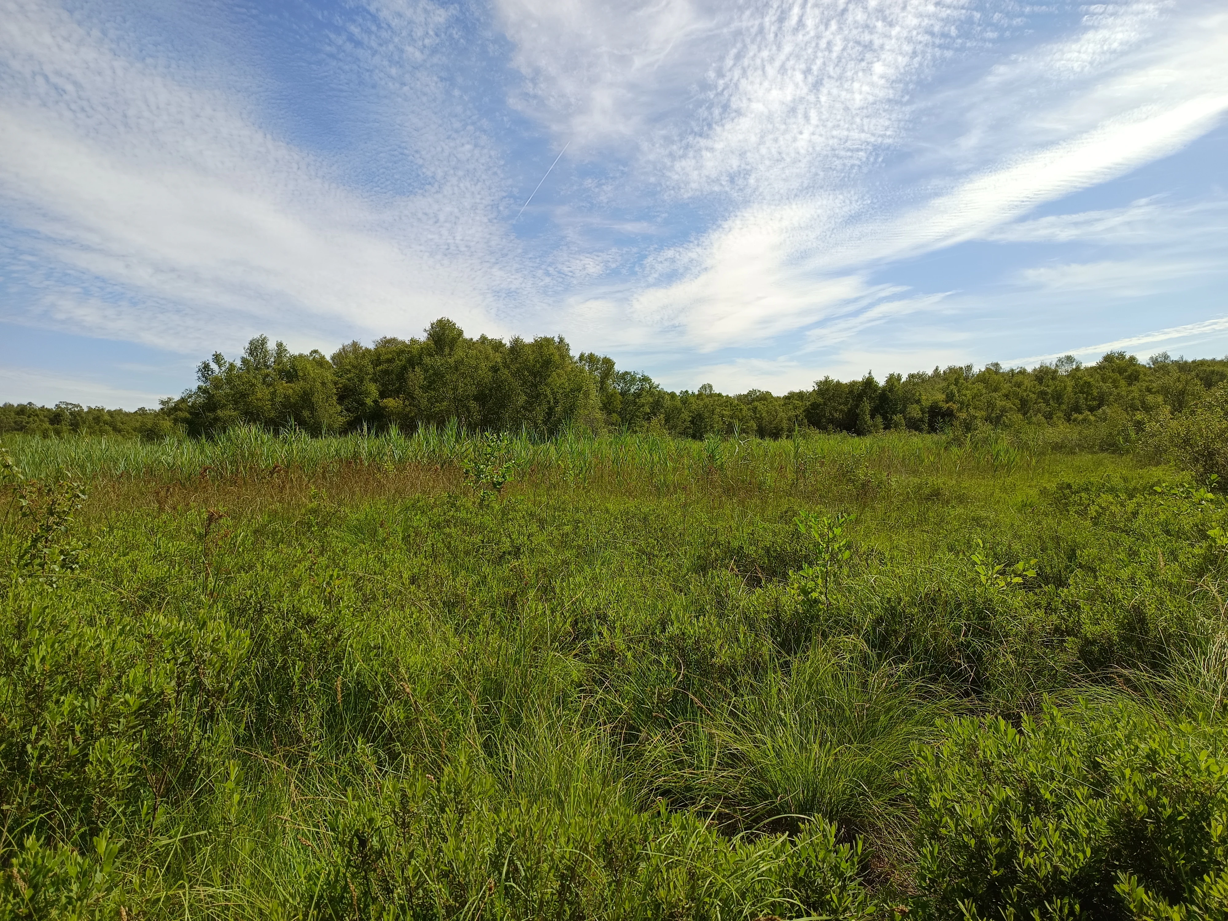
A wide, sunny view of a flat wetland area filled with tall green grasses and sedges, leading to a line of trees in the background under a blue sky with thin clouds.
A view of the wetland and cladietum habitat within the Logné peatland nature reserve.

Logné Bog Regional Nature Reserve history and protected-area timeline

The Logné bog has been recognized for its botanical significance since the 19th century, when eminent specialists documented its unusual plant communities and peatland character. Despite this early awareness, the site remained unprotected for more than a century, and threats to its hydrology and habitats accumulated.

In 1993, the association Bretagne Vivante and its volunteers began a long program of restoration and ecological monitoring, alarmed by the fragility of the ecosystem. This work was later extended and reinforced through LIFE Tourbières projects and Natura 2000 contracts coordinated with the EDENN mixed syndicate. On 28 January 2011, the Conseil régional des Pays de la Loire formally classified the site as a Regional Nature Reserve, giving it a durable legal framework for conservation.

The protection perimeter was extended to 70.64 hectares on 25 September 2020. Since January 2012, the Département de Loire-Atlantique has owned the reserve's core land under its Espaces naturels sensibles policy, securing public stewardship over the most ecologically sensitive portion. Adjacent land on the eastern and southeastern edges remains in private hands, forming a buffer zone around the strictly protected reserve.

Logné Bog Regional Nature Reserve landscape and geographic character

The reserve's landscape is defined by a shallow basin set within gently rolling terrain of the Erdre valley. The basin itself sits at roughly 4 meters above sea level in its central depression, ringed by low hills rising to around 25 meters. These surrounding buttes frame the bog visually and contribute to its sheltered, waterlogged character by limiting runoff and protecting the site from wind.

Within the basin, the surface alternates between open peatland, bog woodland, and small open-water features (the Boires de Logné and de Launay), which are remnants of an ancient lake that once filled the sinkhole. Sphagnum cushions form quaking mounds across the bog, while drier fringes transition into willow and birch woodland. The peripheral margins are dissected by ditches and small streams that connect the bog to its wider catchment, marking a clear transition between the open peatland and the surrounding valley landscape close to Nantes.

The visual impression is one of a quiet, moist, and subtly variegated terrain. Although it lies within 20 kilometers of central Nantes, the reserve has the feel of a much more remote world, dominated by peatland colors, bog pools, and dense low vegetation rather than built features.
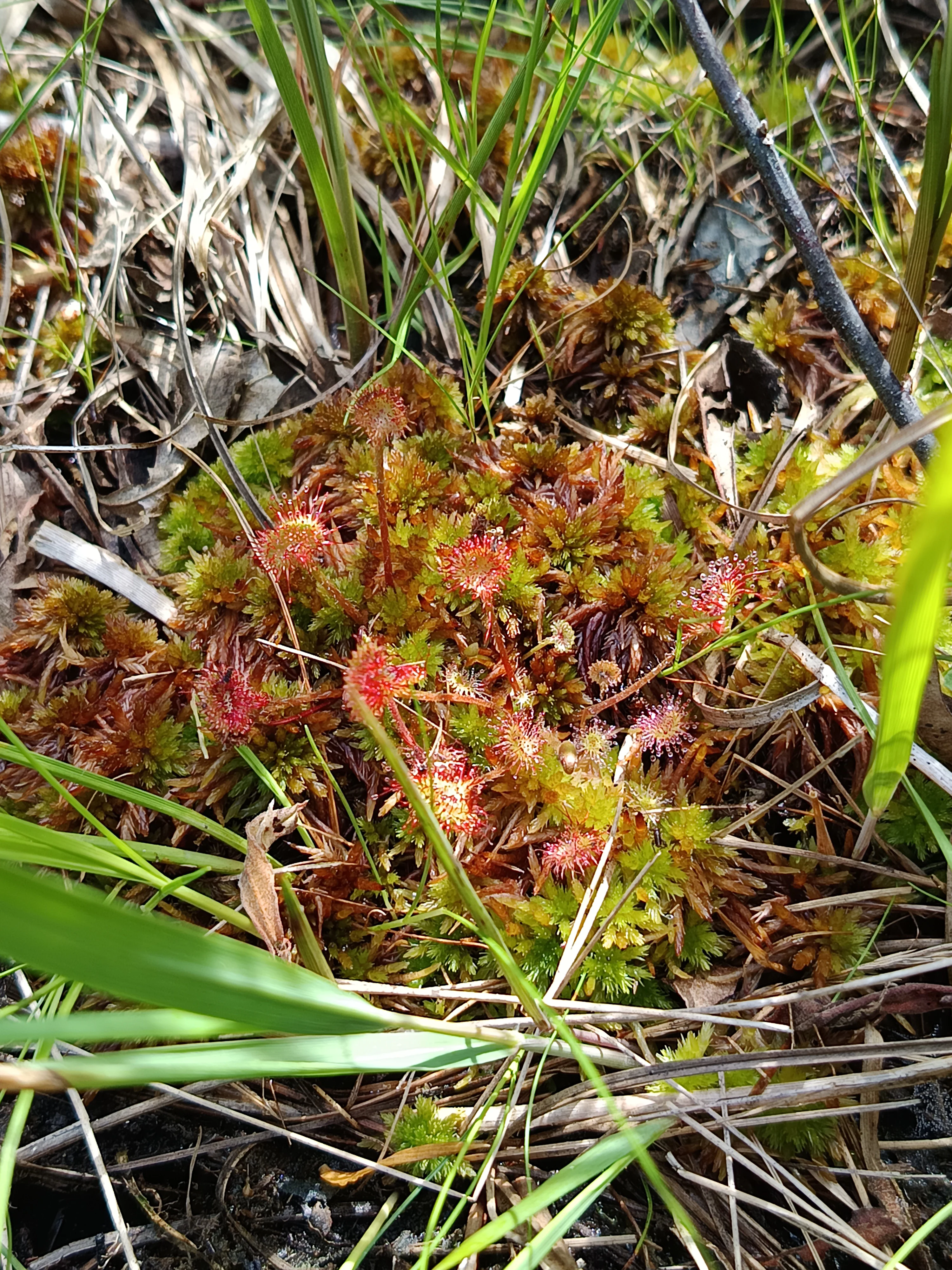
A close-up view of a round-leaved sundew plant with small, red, glandular circular leaves, nestled among green moss and blades of grass.
A cluster of round-leaved sundew, Drosera rotundifolia, growing in the peat bog environment.

Logné Bog Regional Nature Reserve ecosystems, habitats, and plant life

Logné's ecological identity is fundamentally that of an acidic, nutrient-poor peatland ecosystem. The core habitat is a raised sphagnum bog (tourbière à sphaignes), accompanied by a bas-marais (fen) that is slowly infilling. Sphagnum mosses are the keystone organisms, retaining enormous volumes of water and generating the cold, saturated microclimate that supports specialist bog flora.

Vegetation patterns reflect the classic zonation of a lowland raised bog: open moss-dominated centers, transitions through cottongrass and cranberry communities, and peripheral bog woodland on slightly drier ground. Adjacent habitats include cladiaie (fen formed by Cladium mariscus), wet woodland, and ditch-side marsh vegetation. Palynological studies have revealed four millennia of vegetation history, allowing ecologists to interpret the bog as both a present-day refuge and a record of long-term landscape change in the region.

The reserve is ecologically embedded in the wider Erdre marsh network, with functional connections to the Brière, Lac de Grand-Lieu, and the Loire estuary. These linkages are critical for hydrological regulation, species dispersal, and the overall resilience of the wetland complex. The site's ombrotrophic character, defined by extremely limited nutrient supply, is central to its conservation value: any nutrient enrichment could rapidly shift species composition and collapse the bog's distinctive community.
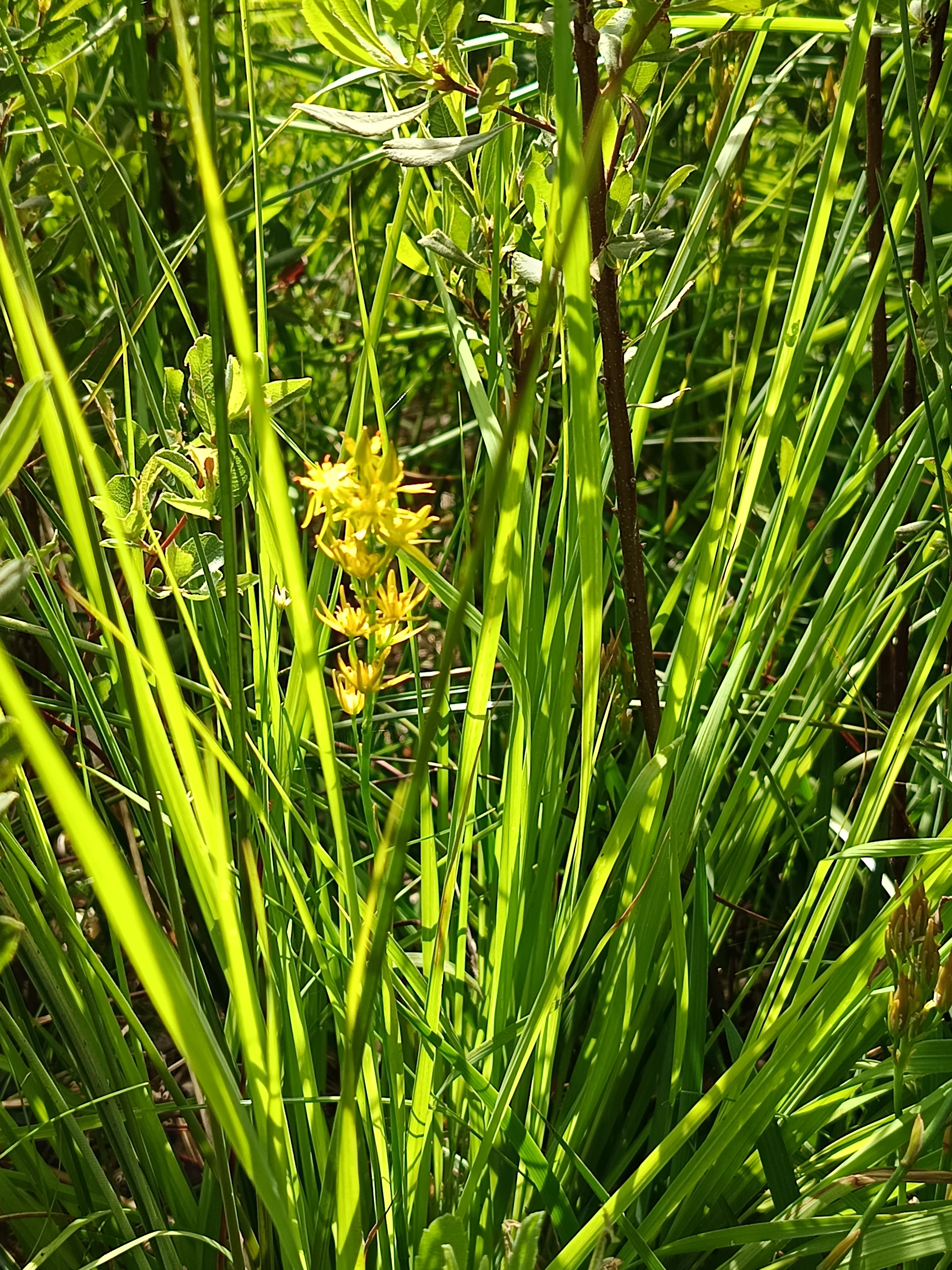
A close-up view of bright yellow Bog asphodel flowers emerging from dense, tall green grasses in a wetland setting.
Bog asphodel (Narthecium ossifragum) blooming in the peatland habitat of the Réserve naturelle régionale de la tourbière de Logné.

Logné Bog Regional Nature Reserve wildlife and species highlights

The reserve's most striking biological asset lies in its invertebrate fauna. Inventories by the Groupe d'étude des invertébrés armoricains have documented 254 spider species, 559 beetle species, 331 moth species, and 28 dragonfly species, among others. The raised bog core hosts a particularly specialized set of species adapted to acidic, oligotrophic conditions, while the peripheral habitats support broader but exceptionally diverse assemblages.

Vertebrate interest is dominated by the herpetofauna, with 9 reptile species and 5 amphibian species recorded in a tiny area, making the reserve notable for serpent, lizard, and amphibian density in western France. The bird community includes around 87 species, with most activity concentrated in the peripheral bog woodland. The central bog itself supports select nesting species characteristic of open peatland, including the hen harrier (Circus cyaneus). The Boire de Logné, an open-water section, attracts waterbirds such as herons and ducks.

Mammal diversity is more modest at about 20 species, including bats, but is ecologically significant because the European otter (Lutra lutra) has used the bog's old extraction pits continuously since 2010. The regular presence of this top wetland predator is widely seen as an indicator of ecosystem recovery, along with successful hydrological restoration across the broader Erdre marshes.

Logné Bog Regional Nature Reserve conservation status and protection priorities

Logné is a small reserve with an outsized conservation role. As one of only three remaining raised bogs in the Grand Ouest of France and the southernmost lowland raised bog of its type in Europe, it preserves peatland habitat that has been almost entirely lost from the surrounding lowlands. Its location near a major metropolitan area makes it both ecologically vulnerable and strategically important for wetland conservation in the Pays de la Loire.

Active conservation began in 1993 under Bretagne Vivante and has since combined volunteer-based hydrological restoration, LIFE Tourbières projects, and Natura 2000 measures. The 2011 classification as a Regional Nature Reserve provided a durable legal framework, while the 2020 perimeter extension strengthened protection of key bog margin habitats. Multiple overlapping statuses, including a biotope protection order dating to 1987, ZNIEFF inventories, ZICO bird-area designation, and Natura 2000 zones, reflect the recognition that no single tool can safeguard such a fragile system.

The site is also significant as a peat-carbon store, a water quality buffer, and a reference site for bog ecology research. Public ownership of the core area by the Département de Loire-Atlantique since 2012 has helped secure long-term stewardship, even though surrounding private lands continue to influence the bog's water balance.

Logné Bog Regional Nature Reserve cultural meaning and human context

The Logné bog sits within the historic Erdre valley landscape, an area long shaped by small-scale peat extraction, marshland management, and rural land use. While no large human settlement lies within the reserve itself, traditional activities in the surrounding communes, including peat cutting and grazing, have historically interacted with the bog and left traces in its present-day structure.

One hypothesis, still being verified, links part of the bog's current configuration to the medieval construction of the Saint-Félix dam in Nantes, which raised Erdre water levels and may have favored sphagnum expansion. Whether or not this proves accurate, it highlights how the reserve's present ecological character is intertwined with centuries of human influence on the local hydrology.

Today, the site operates primarily within a conservation, scientific, and educational culture rather than a traditional rural one. Bretagne Vivante, university programs, and visiting student groups (such as BTS Gestion et Protection de la Nature) treat the reserve as a teaching site for wetland ecology and restoration practice, embedding it in regional environmental education networks.

Top sights and standout views in Logné Bog Regional Nature Reserve

The reserve's strongest points of distinction are its status as a southern relict of European lowland raised bogs, its exceptional invertebrate diversity recorded over decades of surveys, and its compact yet rich herpetofauna. Equally notable is the recovery of the European otter as a regular resident since 2010, signaling genuine ecological restoration in a catchment under long-term stewardship.

For visitors interested in wetland systems and northern plant communities at their southern range edge, Logné offers a compact and scientifically well-documented case study. For regional biodiversity, it functions as both a refuge and a stepping stone within a broader network of Atlantic wetlands including Brière, Lac de Grand-Lieu, and the Loire estuary.

Best time to visit Logné Bog Regional Nature Reserve

Because access is restricted to a small number of guided visits each year organized by Bretagne Vivante, timing is determined by the reserve's own program rather than casual drop-in opportunities. Conditions are generally most favorable for guided excursions in spring through early summer, when sphagnum surfaces are visible, water levels are moderate, and breeding bird and amphibian activity is at its peak.

The local climate is mild and Atlantic, with wetter conditions in winter and a drier window from May to September. Cooler microclimates within the bog make it less attractive during the warmest weeks, when peatland surfaces can feel humid and insect-rich; conversely, autumn and winter visits would suit observers with appropriate clothing, water levels permitting, and exact dates are best confirmed directly with Bretagne Vivante's program.
Monthly climate preview

Long-term monthly temperature and precipitation rhythm recorded at representative coordinates

Réserve naturelle régionale de la tourbière de Logné Climate and Temperature Normals

Representative coordinates record annual temperature progression alongside consistent monthly precipitation rates across twelve measured intervals. Examining the complete climate profile provides deeper monthly context for historical normals within this protected wetland territory.
Annual mean12 °C
5 °C19 °C
Jan
Feb
Mar
Apr10°
May14°
Jun17°
Jul19°
Aug19°
Sep16°
Oct12°
Nov
Dec
Warmest month
July

19.2 °C

Coolest month
January

5 °C

Wettest month
December

2.7 mm/day

Driest month
July

1.5 mm/day

Park location guide

Geography guide, regional context, and park location map for Logné Bog Regional Nature Reserve

Logné Bog Regional Nature Reserve park geography, regions, and map view in France

Understand where Logné Bog Regional Nature Reserve sits in France through a broader geographic reading of the surrounding landscape, nearby location context, and its mapped position within the national park landscape.

How Logné Bog Regional Nature Reserve fits into France

France is a unitary semi-presidential republic and one of the world's largest economies. It borders Belgium, Luxembourg, Germany, Switzerland, Italy, Monaco, Andorra, and Spain, with a maritime border to the United Kingdom. The country is known for its cultural influence, art, cuisine, and political history spanning centuries.

Wider geography shaping Logné Bog Regional Nature Reserve in France

France is located in Western Europe. Metropolitan France extends from the Rhine to the Atlantic Ocean and from the Mediterranean Sea to the English Channel and North Sea. The country borders Belgium, Luxembourg, Germany, Switzerland, Italy, Monaco, Andorra, Spain, and has a maritime border with the United Kingdom.

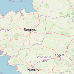
Map view of Logné Bog Regional Nature Reserve

Use this park location map to pinpoint Logné Bog Regional Nature Reserve in France, understand its exact geographic position, and read its mapped placement within the surrounding landscape more clearly.

Pigeon | © OpenStreetMap contributors

Location context for Logné Bog Regional Nature Reserve

Pays de la Loire

Visualizing the rare raised bog habitats, sphagnum terrain, and wetland character of the Erdre valley.

Réserve naturelle régionale de la tourbière de Logné Photos and Protected Area Landscape Scenery

Visual documentation captures the distinct peatland topography, quaking sphagnum cushions, and bog woodland margins defining the reserve. Examining these protected area views reveals the subtle terrain variations and relict wetland habitats characteristic of western France.

A wide, sunny view of a flat wetland area filled with tall green grasses and sedges, leading to a line of trees in the background under a blue sky with thin clouds.

A sunny, wooded peat bog scene featuring a shallow channel of water, mature trees with dappled light, and a rustic wooden bridge structure.

A close-up view of a round-leaved sundew plant with small, red, glandular circular leaves, nestled among green moss and blades of grass.

A close-up view of bright yellow Bog asphodel flowers emerging from dense, tall green grasses in a wetland setting.

Park atlas

Compare adjacent wetland reserves and regional protected terrain across the Erdre valley.

Parks Near Réserve Naturelle Régionale de la Tourbière de Logné and Surrounding Protected Landscapes

Continuing beyond Réserve naturelle régionale de la tourbière de Logné reveals other protected wetland reserves and regional nature domains across the Erdre valley catchment. Comparing adjacent valley terrain provides broader context for Atlantic peatland ecosystems and regional conservation networks.
Nature reservePays de la Loire
About 24 km away#1 closest

East

Réserve naturelle régionale de la ferme de la Chauffetière: Geographic and Landscape Atlas

Protected nature reserve in the Pays de la Loire region

Spanning 30 hectares, the Réserve naturelle régionale de la ferme de la Chauffetière showcases the authentic Mauges bocage landscape. Its varied terrain includes humid valleys, dry calcareous slopes, and agricultural plateaus, providing essential habitat for amphibians, rare orchids, and saproxylic insects within a living, working farm environment.

Area
0.3 km²
Established
2008
IUCN
IV
Relief
Upland
Nature reservePays de la Loire
About 32 km away#2 closest

South

Réserve naturelle régionale du bocage humide des Cailleries: Protected Landscape and Regional Map

Wet bocage and oak woodland in the Lake Grand-Lieu watershed

Covering roughly 18 hectares, this protected area features a fine-textured mosaic of woody hedgerows, wet meadows, and multiple small ponds. The site acts as a functional refuge for varied flora and fauna, illustrating the traditional Atlantic landscape character within western France through its structured management of meadows and pond systems.

Area
0.182 km²
Established
2012
IUCN
IV
Relief
Lowland
A soft watercolor illustration depicting a serene wetland scene with a calm body of water, grassy marshland, and distant rolling hills under a pale sky.
Nature reservePays de la Loire
About 56 km away#3 closest

West

Réserve naturelle régionale du marais de Brière: Protected Wetland Geography in Western France

A vital conservation mosaic of reedbeds, canals, and flooded meadows.

Located in the Pays de la Loire region, this protected area preserves the distinctive Grande Brière marshland landscape. The reserve manages a complex network of channels, islands, and damp meadows, providing essential habitat for migratory waterbirds and wetland wildlife. It represents a significant effort to maintain the ecological integrity of inland marsh complexes through structured regional conservation.

Area
8.36 km²
Established
2012
IUCN
IV
A horizontal watercolor painting depicting a soft coastal scene with green grassy shores; distant hills; and a calm expanse of water.
Nature reservePays de la Loire
About 60 km away#4 closest

West

Réserve naturelle régionale de la pointe Saint-Gildas: Coastal Geography and Protected Map

Regional Nature Reserve in Pays de la Loire, France

The Réserve naturelle régionale de la pointe Saint-Gildas represents a significant protected coastal headland. Located in Loire-Atlantique, the site encompasses 11.5 hectares of land where freshwater estuarine influences converge with Atlantic saltwater, providing a unique focus for regional geographic and landscape conservation studies.

Area
0.115 km²
Established
2014
IUCN
IV
Relief
Lowland
Nature reserveRomania
About 63 km away#5 closest

Southwest

Réserve naturelle régionale des marais du Bout de Sac: Protected Marsh Geography

Coastal wetland habitat and protected marshland terrain

The Réserve naturelle régionale des marais du Bout de Sac represents 187.1 hectares of preserved wetland habitat. Its landscape includes reclaimed polders, wet meadows, and a network of tidal channels. This site offers significant value for understanding the ecological structure of coastal marshlands and their role as habitats for waterbird populations near the Atlantic interface.

Established
2025
Relief
Lowland
Water
Water-dominated
Watercolor painting of a coastal polder landscape with green grassy mounds, light yellow flat areas, and soft purple hills in the distance.
Nature reservePays de la Loire
About 66 km away#6 closest

Southwest

Réserve naturelle régionale du polder de Sébastopol: Coastal Wetland and Polder Geography

Protected coastal landscape on the Île de Noirmoutier.

This 133-hectare nature reserve in the Pays de la Loire region encompasses a distinctive 19th-century drainage landscape. The area features a long, narrow geometry of brackish ponds and salt-influenced terrain that provides essential stopover and breeding habitats for coastal waterbirds along the Vendée shoreline.

Area
1.33 km²
Established
2008
IUCN
IV
Nature reservePays de la Loire
About 66 km away#7 closest

East

Réserve naturelle régionale de Basses-Brosses et Chevalleries: Protected Area Mapping

A dense bocage landscape in the Pays de la Loire region

This regional nature reserve protects a well-preserved mosaic of meadows, cultivated plots, and wooded hedgerows across 90 hectares. The site serves as a vital ecological anchor in the Maine-et-Loire department, maintaining traditional land patterns and diverse species habitats that define the historic rural character of the Anjou countryside.

Area
0.9 km²
Established
2012
IUCN
IV
Nature reserveLoire-Atlantique
About 71 km away#8 closest

West

Réserve naturelle régionale de l'étang du pont de fer: Protected Wetlands of Loire-Atlantique

Coastal freshwater pond, wooded buffers, and wetland connectivity.

This regional nature reserve encompasses a sizeable freshwater pond and surrounding marshes, serving as a vital link in the chain of wetlands between the Vilaine estuary and the Guérande region. Its distinctive landscape, defined by floating sedge islets and dense alder woodland, supports a high density of avifauna and rare plant species. As a key component of the protected terrain in Loire-Atlantique, the reserve offers insight into coastal wetland ecosystems and their function as biodiversity corridors in western France.

Area
0.626 km²
Established
2008
IUCN
IV
Relief
Lowland

Common questions about visiting, size, designation, and location context for Logné Bog Regional Nature Reserve

Logné Bog Regional Nature Reserve FAQs for park facts, access, geography, and protected area context

Find quick answers about Logné Bog Regional Nature Reserve, including protected-area facts, park geography, trail and visitor context, and how the park fits into its surrounding country and regional landscape.
MoriAtlas Explorer

Continue Your Protected Areas Search Across the Global Atlas

Deepen your exploration by continuing the structured search for national parks and protected areas worldwide. Utilize the comprehensive filtering capabilities to compare different conservation landscapes and refine your understanding of global park geography. Discover more about the distribution and characteristics of protected natural areas.

Global natural geography