Mori Atlas logo
Nature reserveTrockenhänge südöstlich Lommatzsch

Tracing the mapped boundaries and unique ecological terrain of this vital German nature reserve

Trockenhänge südöstlich Lommatzsch: Protected Dry Grasslands and Oak Woodland Landscapes in Saxony

(Naturschutzgebiet 'Trockenhänge südöstlich Lommatzsch')

The Trockenhänge südöstlich Lommatzsch nature reserve protects a fragmented series of dry-slope habitats along the Ketzerbach and Käbschützer Bach valleys in Saxony, Germany. This complex landscape of semi-dry grasslands and warm-climate oak woodlands provides a refuge for rare thermophilic plant species and specialized invertebrate populations within the broader agricultural plateau of the Lommatzscher Pflege. The area serves as a significant regional site for botanical conservation, reflecting over a century of protection efforts dedicated to preserving its igneous geology and diverse microhabitats.

dry grasslandsemi-dry grasslanddry-warm oak woodlandnature reserveSaxon conservationthermophilic flora

Trockenhänge südöstlich Lommatzsch

Nature reserve

Park overview

Structured park overview, official facts, and landscape profile for Trockenhänge südöstlich Lommatzsch

Trockenhänge südöstlich Lommatzsch park facts, protected area profile, and essential visitor context

Review the core facts for Trockenhänge südöstlich Lommatzsch, including designation, size, terrain, visitor scale, habitats, and operating context in one park-focused overview.

About Trockenhänge südöstlich Lommatzsch

Trockenhänge südöstlich Lommatzsch occupies a notable position within Saxony's network of small, ecologically focused nature reserves. Although considerably more modest in scale than Germany's large national parks, it concentrates environmental value in a landscape where dry-grassland and warm-oak habitats have become exceptionally rare. Sixteen separate parcels, distributed across the slopes and side valleys of the Ketzerbach and its tributary the Käbschützer Bach, together create a protected mosaic of dry meadows, semi-dry swards, oak woodland on dry-warm sites, and narrow floodplain along the Käbschützgrund. The largest single contiguous area within the reserve covers about 65.7 hectares, while the total protected area is around 140 hectares.

The regional context is important to understanding the reserve. The Lommatzscher Pflege, the broader traditional farming landscape in which the reserve sits, is one of Saxony's most fertile agricultural areas, producing intensive crop cultivation across loess-covered plateaus. Within this heavily cultivated setting, the valley slopes of the Ketzerbach retain fragments of semi-natural vegetation that contrast strikingly with the surrounding farmland. These fragments are remnants of a once more widespread dry-slope flora whose survival is owed to centuries of relatively low-intensity grazing and the inherent dryness of the south-facing slopes above the stream.

Ecologically, the reserve functions as a refuge for thermophilic plant and invertebrate communities that have largely vanished from the Saxony landscape due to land-use intensification, shrub encroachment, and nitrogen deposition. Because the habitat types require active management to suppress succession and protect rare species, the area is categorized as IUCN Category IV, a Habitat/Species Management Area, reflecting the need for ongoing intervention rather than purely passive protection.

The reserve's character is quietly dramatic. Slopes of Meißen monzonite, an unusual plutonic rock that outcrops in only a few places in Saxony, alternate with loess-capped plateau edges and small floodplain pockets along the tributary brooks. The combination creates an environment of warm, well-drained soils, dry grassland swards, scattered ancient oaks, and quiet streams, forming one of the more botanically diverse dry-habitat landscapes in central Saxony.

Quick facts and research context for Trockenhänge südöstlich Lommatzsch

Trockenhänge südöstlich Lommatzsch is a nature reserve in the Landkreis Meißen, Saxony, located southeast of Lommatzsch in the Lommatzscher Pflege. It consists of sixteen separate parcels along the Ketzerbach valley and the Käbschützgrund tributary, with a total area of about 140 hectares. The site holds IUCN Category IV status as a Habitat/Species Management Area and is classified under the German Naturschutzgebiet designation with the code D 108. Geologically the reserve sits primarily on Meißen monzonite, a deep-seated igneous rock that produces warm, nutrient-poor soils ideal for dry-grassland communities.

Protection and recognition

Examine documented conservation data, management scope, and protected area records

Trockenhänge südöstlich Lommatzsch Protection Status and Designated Area Records

Trockenhänge südöstlich Lommatzsch maintains structured records detailing official protected area designation metrics and international database listings. Analysts verify conservation status parameters and baseline administrative records for comprehensive geographic tracking.

Protection details

WDPA ID
555546383
Park context

Deeper park guide and search-rich context for Trockenhänge südöstlich Lommatzsch

Trockenhänge südöstlich Lommatzsch history, landscape, wildlife, and travel context

Explore Trockenhänge südöstlich Lommatzsch through its history, landscape character, ecosystems, wildlife, conservation priorities, cultural context, and seasonal travel timing in a structured park guide built for atlas discovery and search intent.

Why Trockenhänge südöstlich Lommatzsch stands out

Trockenhänge südöstlich Lommatzsch is recognized primarily for its surviving dry and semi-dry grassland ecosystems and the associated rare plant species found on south-facing slopes above the Ketzerbach. The reserve is notable for containing the only currently documented Saxon site of the grey scabious (Scabiosa canescens) at the Piskowitz quarry, and for historically hosting populations of meadow pasqueflower, black cumin, and purple mullein that have shaped conservation interest in the region for more than a century. Beyond its vascular plant diversity, the area is also distinguished by an outstanding invertebrate fauna. The Spanish flag moth, a species of significant conservation concern across Europe, has populations here that are of supra-regional importance, complemented by dozens of beetle and butterfly species recorded in surveys around the year 2000.
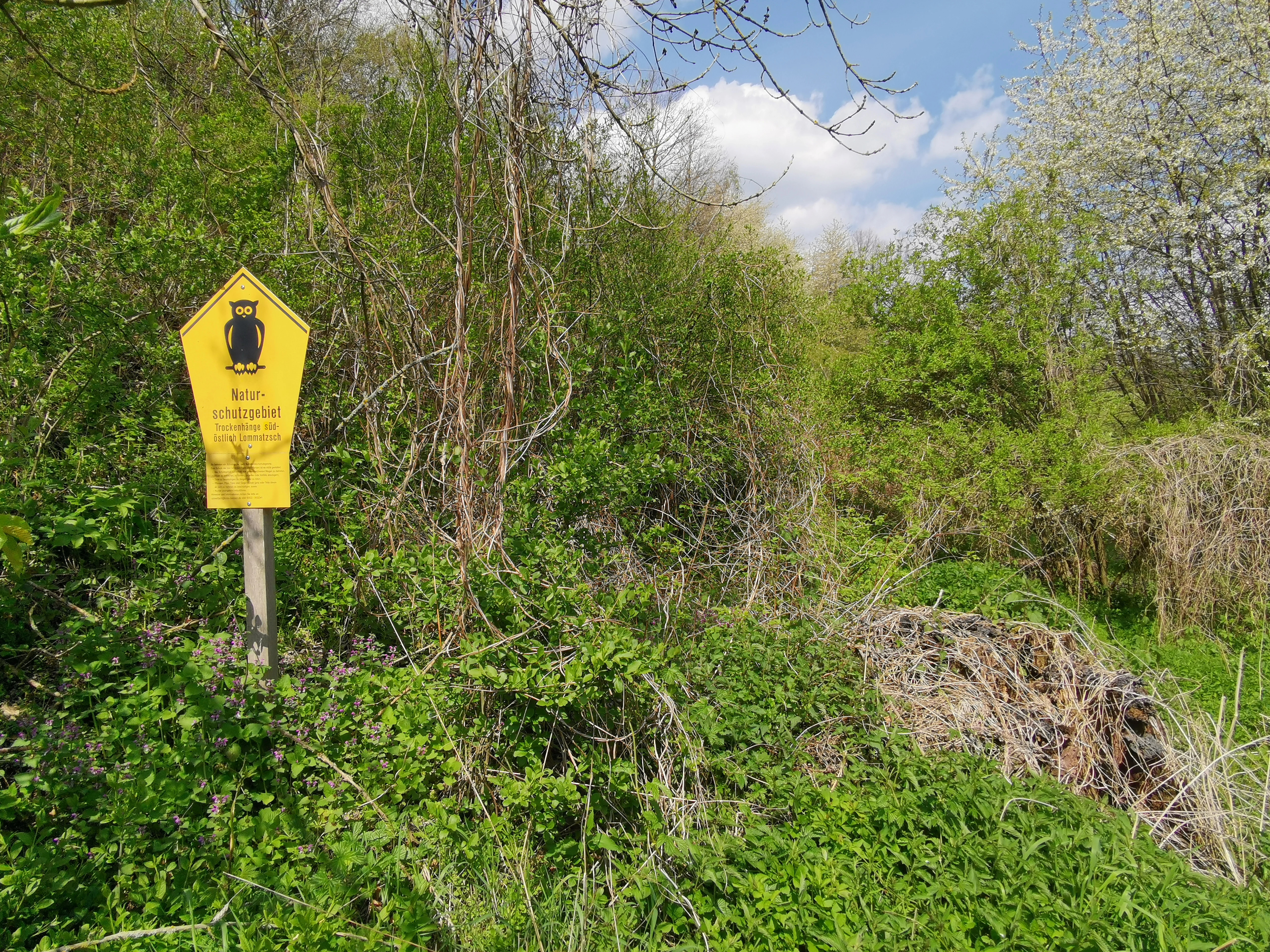
A yellow pentagonal sign with a black owl symbol and text reading Naturschutzgebiet Trockenhänge bei Lommatzsch on a wooden post, surrounded by green bushes and trees under a blue sky with clouds.
A yellow nature reserve sign for Trockenhänge bei Lommatzsch stands amidst green vegetation.

Trockenhänge südöstlich Lommatzsch history and protected-area timeline

The history of Trockenhänge südöstlich Lommatzsch stretches back to the late nineteenth century, when the Dresden botanist Oscar Drude first drew attention to the unusual flora growing on the dry slopes of the Ketzerbachtal. Around 1900, plant communities hosted in this valley, including species then considered remarkable for Saxony, became a focus of scientific interest and early conservation debate.

In 1911, an assistant of Drude submitted a proposal to the Royal Saxon Ministry of the Interior on behalf of the Landesverein Sächsischer Heimatschutz, the regional homeland protection society, requesting the creation of multiple 'Naturschutzbezirke', or natural protection districts. Among the areas listed was the hill flora between Schieritz and Prositz that the modern reserve now protects. With the state slow to act, the Landesverein itself acquired several of the targeted slopes and managed them as its own nature reserves. In 1920 the landowner Hensel purchased a slope near Piskowitz and shortly afterward the Mühlhügel hill near Prositz, adding to the network of privately protected sites.

Following the political changes of 1946, the Landesverein Sächsischer Heimatschutz was expropriated, but two small parcels survived as officially designated natural monuments (Naturdenkmale) and from 1948 as Flächennaturdenkmale, or area natural monuments. These surviving plots were maintained on a voluntary basis by interested specialists throughout the following decades.

After the political changes of 1989 and 1990, the dry grasslands of the Ketzerbach valley were comprehensively reassessed by the State Environmental Office in Radebeul. The reconstituted Landesverein Sächsischer Heimatschutz subsequently repurchased in 2014 and 2017 some of the historically protected areas it had once owned. Finally, on 19 December 2011, the Landkreis Meißen issued the formal ordinance establishing the protected area 'Trockenhänge südöstlich Lommatzsch', exactly one hundred years after the society's original 1911 petition.

Trockenhänge südöstlich Lommatzsch landscape and geographic character

The landscape of Trockenhänge südöstlich Lommatzsch is shaped by the narrow valley system of the Ketzerbach and its small tributary the Käbschützer Bach, which together cut through the broader agricultural highlands of the Mittelsächsisches Lösshügelland. The slopes above the streams are the reserve's defining feature: south- and west-facing hillsides of dry, often stony ground that historically supported semi-natural dry grassland and open oak woodland rather than intensive agriculture. The valley itself is comparatively shallow and winding, creating a string of dry slope exposures alternating with small shaded tributary draws.

Geology plays an unusually direct role in the landscape's character. Almost the entire reserve sits on Meißner Monzonit, a distinctive deep-seated igneous rock of siliceous composition that weathers slowly and produces warm, nutrient-poor, well-drained soils. In a few locations the underlying rock is formed instead by Upper Carboniferous volcanic rocks, while on the broader plateau surfaces glacial loess has been deposited over the bedrock. Together these substrates create a patchwork of basic, acidic, loamy, and silty soil conditions that supports the reserve's habitat diversity within a compact area.

Above the slopes the landscape opens into the agricultural plateau of the Lommatzscher Pflege, one of the most intensely farmed regions of Saxony. The transition from open cereal fields to the protected dry slopes is abrupt, marking the boundary between modern cultivation and a relict semi-natural environment. Within the Käbschützgrund, the smallest and most sheltered of the valley sections, the dry slopes give way to a thin floodplain where wet meadow and brook-side vegetation create a quieter, more enclosed character, in stark contrast to the dry, sun-exposed hillside habitats that define most of the reserve.

The overall impression is one of fragmentation rather than grand scale: a system of small valleys and dry hillsides interlaced with cultivated plateau land, where the reserve's value lies in the persistence of unusual microhabitats within an otherwise heavily transformed agricultural setting.

Trockenhänge südöstlich Lommatzsch ecosystems, habitats, and plant life

The ecological character of Trockenhänge südöstlich Lommatzsch is dominated by semi-natural dry and semi-dry grassland communities on south-facing slopes above the Ketzerbach and Käbschützer Bach. These habitats have become extremely rare in Saxony due to decades of agricultural intensification, fertilization, and the abandonment of traditional grazing practices, making the surviving fragments of high conservation interest. The reserve also includes dry-warm oak woodlands on the same slopes and a small floodplain zone in the Käbschützgrund, creating a small but varied mosaic of dry-soil and moisture-influenced communities.

The underlying geology, particularly the Meißen monzonite substrate, contributes significantly to the area's ecological identity. Silicate-rich bedrock weathers to produce warm, well-drained, relatively base-poor soils that favor specialist dry-grassland and steppe-like plant communities. Where loess covers the plateau edges, soil conditions shift, and the resulting ecological transitions contribute to the habitat diversity within the reserve.

Botanical surveys have documented 570 species of vascular plants across the protected area, of which 23 are classified as endangered in Saxony. Historically important species once recorded here include black cumin, meadow pasqueflower, purple mullein, the middle broomrape-related thesium (Mittleres Vermeinkraut), the three-toothed orchid, and the spotted cat's ear. Several of these have declined or vanished since the early twentieth century, but their surviving relatives, including the earth sedge, large speedwell, Bolognese bellflower, and branched grass lily, continue to anchor the area's botanical significance. The Piskowitz quarry hosts the only currently confirmed Saxon site of the grey scabious, a particularly notable regional record.

Beyond plants, dry grasslands in central Europe support disproportionately rich invertebrate communities, and the reserve illustrates this pattern clearly. Around the year 2000, surveys recorded 185 beetle species and 36 butterfly species, with the Spanish flag moth singled out as having populations of supra-regional conservation value. The invertebrate fauna overall has been described as outstanding, reinforcing the reserve's importance as a refuge for thermophilic species on the northern fringes of their European range.

Trockenhänge südöstlich Lommatzsch wildlife and species highlights

Wildlife interest at Trockenhänge südöstlich Lommatzsch centers less on large mammals and more on the often-overlooked communities of invertebrates that depend on dry grasslands and warm oak woodland. Surveys conducted around 2000 documented 185 beetle species within the reserve and 36 butterfly species active during the day. Within these groups, particular attention has been drawn to moth species such as the Spanish flag, whose populations here are considered of supra-regional importance for conservation networks across Germany.

The reserve's combination of dry slopes, open oak canopy, loose rock and scree around old quarry faces, and small wet meadow strips in the Käbschützgrund creates unusually diverse microhabitats for invertebrates. Dry, sun-exposed terrain, dead wood in scattered veteran oaks, and small areas of bare ground together provide conditions that many specialist species require. Although most individual species are inconspicuous, the overall invertebrate fauna has been explicitly described as outstanding by regional conservation authorities.

The dry-warm oak woodlands contribute additional habitat value, supporting saproxylic beetle communities associated with old trees and sun-exposed wood. Although not highlighted with the same emphasis as the grassland invertebrates, the woodland parcels complement the dry-slope habitats and extend both the structural and seasonal diversity of the reserve's wildlife profile.

No detailed records of larger mammal species, breeding bird communities, or herpetofauna were documented in the source material, so the wildlife section appropriately emphasizes the documented invertebrate focus rather than speculating on unrecorded groups.

Trockenhänge südöstlich Lommatzsch conservation status and protection priorities

Trockenhänge südöstlich Lommatzsch holds conservation significance that extends well beyond its modest 140-hectare size. The reserve protects one of the few remaining complexes of dry and semi-dry grassland in Saxony along with associated dry-warm oak woodland, habitat types that have declined sharply across central Europe during the twentieth and twenty-first centuries. The area is classified as IUCN Category IV, reflecting its role as a Habitat/Species Management Area in which active intervention is required to maintain the ecological character of the site.

Conservation interest in the Ketzerbach valley long predates the formal designation. Botanists around 1900 recognized the valley as one of Saxony's outstanding sites for thermophilic flora. Subsequent protection efforts have spanned more than a century, from the Landesverein Sächsischer Heimatschutz's early twentieth-century acquisitions, through the natural monument designations of the GDR period, to repurchase of key areas in 2014 and 2017, and finally the formal designation as a Naturschutzgebiet in 2011. This long and layered protection history has given the reserve unusual continuity for a German nature reserve of its size.

The reserve is particularly important for threatened species. Twenty-three endangered vascular plant species have been documented, and the site holds the only confirmed Saxon occurrence of the grey scabious. The Spanish flag moth is recorded as a population of supra-regional significance, and overall invertebrate diversity is considered outstanding, giving the area a disproportionately high biodiversity value per hectare relative to many larger protected landscapes in Saxony.

From a management perspective, the reserve's fragmented structure (sixteen non-contiguous parcels) requires careful coordination between habitat maintenance on dry slopes, control of woody succession in open grassland, and preservation of the smaller floodplain habitats in the Käbschützgrund. Its location within an intensively farmed agricultural region also makes the reserve a focal point for landscape-scale ecological thinking, preserving biodiversity in an otherwise cultivation-dominated setting.

Trockenhänge südöstlich Lommatzsch cultural meaning and human context

The cultural context of Trockenhänge südöstlich Lommatzsch is closely tied to the broader identity of the Lommatzscher Pflege, a richly productive agricultural district long celebrated in Saxony for its fertile loess soils and traditional farming culture. Within this intensively cultivated landscape, the dry slopes of the Ketzerbach valley long served as marginal terrain where traditional grazing and hay-cutting maintained semi-natural grassland that farmers elsewhere in the Pflege increasingly replaced with cropland.

The reserve also represents an important chapter in the history of organized nature conservation in Saxony. The Landesverein Sächsischer Heimatschutz, founded in the early twentieth century to protect regional heritage landscapes, played a decisive role in identifying, acquiring, and managing these slopes long before formal state protection existed. The eventual designation of the reserve in 2011, exactly one hundred years after the society's original 1911 petition, has been interpreted within conservation history as a closing of a long arc of effort by committed local and regional naturalists.

Today the surrounding villages of Wahnitz, Piskowitz, Prositz, and Zöthain remain small rural communities whose agricultural traditions continue to shape the visual and ecological setting of the reserve, even where the protected slopes themselves are managed primarily for biodiversity rather than for agricultural production.

Top sights and standout views in Trockenhänge südöstlich Lommatzsch

Trockenhänge südöstlich Lommatzsch is notable for the century-long arc of conservation effort that culminated in its 2011 designation; from Oscar Drude's late nineteenth-century botanical observations, through the Landesverein Sächsischer Heimatschutz's early protection work, to formal state protection a hundred years later. This layered conservation history is itself one of the reserve's distinguishing features.

Ecologically, it offers an unusually complete dry-slope complex for Saxony, comprising dry grassland, semi-dry swards, dry-warm oak woodland, and a small floodplain, all set on the unusual substrate of Meißen monzonite. Its botanical richness (570 vascular plant species, 23 of them endangered) and the documented Saxon-only site for grey scabious together make it a reference location for thermophilic plant conservation in the region.

Best time to visit Trockenhänge südöstlich Lommatzsch

As a low-elevation dry grassland reserve in the rolling agricultural hills of central Saxony, Trockenhänge südöstlich Lommatzsch is most expressive in late spring and early summer, when thermophilic dry-grassland plants such as meadow pasqueflower, purple mullein, and early-flowering sedges are at their peak. Late May through June typically brings the densest display of characteristic dry-slope flora and the highest activity among grassland butterflies.

Summer visits also have value, with continued butterfly and beetle activity and warm, sunny conditions that suit both observation and photography of the dry slopes; however, later in the year the visual character of the reserve shifts as grasses dry out and colors fade toward yellow and brown. Early autumn can be rewarding for those interested in the structural contrast between dry slopes and the small floodplain vegetation of the Käbschützgrund, while winter visits offer quieter observation of landform and woodland structure but limited botanical or invertebrate interest.


Monthly climate preview

Long-term temperature ranges and monthly precipitation patterns across the year

Trockenhänge südöstlich Lommatzsch Climate Normals and Weather by Month

Representative coordinates track measured annual temperature swings alongside consistent monthly precipitation records for Trockenhänge südöstlich Lommatzsch. Deeper monthly analysis examines the full twelve-month climatology dataset for detailed temperature averages.
Annual mean9 °C
-1 °C19 °C
Jan-1°
Feb
Mar
Apr
May13°
Jun17°
Jul19°
Aug19°
Sep14°
Oct
Nov
Dec
Warmest month
July

18.9 °C

Coolest month
January

-1.4 °C

Wettest month
July

2.8 mm/day

Driest month
April

1.3 mm/day

Park location guide

Geography guide, regional context, and park location map for Trockenhänge südöstlich Lommatzsch

Trockenhänge südöstlich Lommatzsch park geography, regions, and map view in Germany

Understand where Trockenhänge südöstlich Lommatzsch sits in Germany through a broader geographic reading of the surrounding landscape, nearby location context, and its mapped position within the national park landscape.

How Trockenhänge südöstlich Lommatzsch fits into Germany

Germany is a federal republic in Western and Central Europe with a population of over 83 million across sixteen constituent states. It is Europe's largest economy by nominal GDP and a major global exporter and importer. The capital is Berlin, and the country borders Denmark, Poland, Czech Republic, Austria, Switzerland, France, Luxembourg, Belgium, and the Netherlands.

Wider geography shaping Trockenhänge südöstlich Lommatzsch in Germany

Germany is located in Western and Central Europe, spanning 357,022 km². It borders Denmark to the north, Poland and the Czech Republic to the east, Austria and Switzerland to the south, and France, Luxembourg, Belgium, and the Netherlands to the west. The country has coastlines on the Baltic Sea and North Sea to the north, with the Alps located in the southern region.

Map view of Trockenhänge südöstlich Lommatzsch

Use this park location map to pinpoint Trockenhänge südöstlich Lommatzsch in Germany, understand its exact geographic position, and read its mapped placement within the surrounding landscape more clearly.

Pigeon | © OpenStreetMap contributors

Location context for Trockenhänge südöstlich Lommatzsch

Saxony

Visualizing dry grassland habitats and valley terrain across the reserve

Trockenhänge südöstlich Lommatzsch Photos and Landscape Scenery

Photographic records illustrate the steep south-facing slopes, dry-warm oak woodlands, and fragmented valley topography of Trockenhänge südöstlich Lommatzsch. Examining these visual habitats provides a clearer understanding of the rare botanical terrain and protected nature reserve character found within the Ketzerbach valley.

A yellow pentagonal sign with a black owl symbol and text reading Naturschutzgebiet Trockenhänge bei Lommatzsch on a wooden post, surrounded by green bushes and trees under a blue sky with clouds.

A purple pasqueflower with feathery foliage growing among moss, dry grass, and a small rock on the ground.

Park atlas

Compare regional valley reserves and connected conservation landscapes across Saxony

Other Parks Near Trockenhänge südöstlich Lommatzsch and Surrounding Protected Areas

Browsing other parks near Trockenhänge südöstlich Lommatzsch reveals distinct dry-slope habitats and valley ecosystems across the surrounding region. Extending the geographic review provides deeper context on Saxon botanical reserves and fragmented protected landscapes.
A soft, light-toned watercolor painting of a low, rolling landscape with green hills, sparse vegetation, and a suggestion of wetland or pond in the foreground.
Nature reserveSachsen
About 9.5 km away#1 closest

Northeast

Seußlitzer und Gauernitzer Gründe: Protected Nature Reserve Map and Landscape Overview

Regional geography and habitat boundaries in the Sachsen Elbe valley.

Spanning steep slopes and narrow brook valleys on both sides of the Elbe, Seußlitzer und Gauernitzer Gründe is a defining nature reserve in Sachsen. This protected area supports a diverse mix of dry herbaceous vegetation and mature deciduous forest, serving as a critical component of the local ecological network within the broader Upper Elbe landscape.

Area
3.57 km²
Established
2013
IUCN
IV
Relief
Upland
Nature reserveSachsen
About 11 km away#2 closest

East

Winzerwiese und Gosebruch: Protected Nature Reserve and Valley Geography in Sachsen

Mapping protected wet meadows and floodplain woodlands

Winzerwiese und Gosebruch is a distinctive nature reserve in Sachsen, Germany, centered on a small valley along the Gosebach stream. This protected area creates a dense mosaic of wet meadow, marshy woodland, and dry deciduous forest, offering a significant look at the region's diverse botanical landscape and river-valley geography.

Area
0.116 km²
Established
1967
IUCN
IV
A soft watercolor painting depicting a pale, hazy landscape with green grassy fields, light green trees, and distant faint mountains under a pastel sky.
Protected areaSaxony
About 19 km away#3 closest

North

Gohrischheide und Elbniederterrasse Zeithain: Geography and Protected Area Overview

Analyzing the inland dunes and dry heath landscape of the Elbe river terrace

Discover the unique geography of Gohrischheide und Elbniederterrasse Zeithain in Saxony, a protected area known for its expansive inland dunes and dry heath habitats. This region represents a rare combination of post-glacial sand landscapes and semi-open forest mosaics that reflect long-term ecological evolution and distinct regional environmental conditions.

Area
28.47 km²
Established
2011
Relief
Lowland
Climate
Temperate
Nature reserveSachsen
About 23 km away#4 closest

West

Scheergrund Nature Reserve: Geographic Atlas and Protected Landscape Overview

Mapping the geology and woodland history of the Leisnig region

Scheergrund functions as a vital nature reserve and geological reference site within the Saxon landscape. This area provides insight into Holocene tufa systems, ancient dam structures, and the complex interplay between spring-fed stream morphology and human development in the Freiberger Mulde tributary valley.

Area
0.578 km²
Established
1961
IUCN
IV
A horizontal watercolor illustration showing a calm pond in the foreground, with lush green vegetation on the banks and rolling hills in the background under a soft sky.
Nature reserveMeißen
About 23 km away#5 closest

East

Dippelsdorfer Teich Nature Reserve: Geographic Insights and Landscape Context

Historic Saxon pond management and regional protected landscape.

The Dippelsdorfer Teich serves as a primary example of historical pond construction and nature protection in the northern Dresden countryside. This 69 hectare reservoir captures a blend of ecological, cultural, and recreational values within the Meißen region. Users can examine its physical layout, the dam structure, and the integration of heritage transport within this managed lowland environment.

Area
0.69 km²
Established
1528
Relief
Lowland
Scope
Terrestrial
A watercolor painting showing a calm pond with a small island of green trees and distant rolling hills under a soft pink and yellow sky.
Nature reserveMeißen District
About 25 km away#6 closest

East

Frauenteich Moritzburg: Mapping the Protected Wetland Landscapes of Meißen District

Glacial pond basins and diverse forest habitats in Saxony.

Frauenteich Moritzburg serves as a core component of Saxony's pond landscape, protecting a rich sequence of shoreline vegetation and open water. Its geography reflects the results of ancient glacial activity, creating a unique environment where sandy ridges and wet meadows coexist. This nature reserve provides essential refuge for bird populations, making it a focal point for understanding the natural, protected terrain within the broader Meißen District environment.

Area
2.02 km²
Established
1954
IUCN
IV
Relief
Lowland
A horizontal watercolor painting showing a soft, atmospheric wetland scene with green meadows, tall grasses, distant tree lines, and a pale pink and yellow sky.
Nature reserveBrandenburg
About 27 km away#7 closest

North

Kleine Röder Nature Reserve: Mapped Wetland Geography and Protected Landscape in Brandenburg

A vital Elbe-Mulde lowland corridor near Bad Liebenwerda

The Kleine Röder Nature Reserve functions as a major ecological link in northeastern Germany, protecting a 385 hectare mosaic of fens, wet meadows, and alluvial forests. This site is defined by its water-dominated terrain and its role as a habitat corridor in the Elbe-Mulde lowland, encompassing both rare wetland flora and the historic Kosilenzien Slavic ringwall within its official boundaries.

Area
3.65 km²
Established
2011
IUCN
IV
Nature reserveFreistaat Sachsen
About 31 km away#8 closest

Southeast

Windberg Nature Reserve: Mapping the Forested Ridge and Protected Landscape of Saxony

Geology, mining heritage, and protected oak-beech forest ecosystems

Windberg serves as the prominent local landmark for Freital, defined by its elongated forested plateau and complex tectonic geography. This nature reserve offers a study in the intersection of environmental conservation and human industrial history, featuring Saxony's deepest cave and varied habitats within the eastern Ore Mountains foothills.

Established
1967
Relief
Mountain
Climate
Temperate
Access
Easy access

Common questions about visiting, size, designation, and location context for Trockenhänge südöstlich Lommatzsch

Trockenhänge südöstlich Lommatzsch FAQs for park facts, access, geography, and protected area context

Find quick answers about Trockenhänge südöstlich Lommatzsch, including protected-area facts, park geography, trail and visitor context, and how the park fits into its surrounding country and regional landscape.
MoriAtlas Explorer

Continue Your Protected Areas Search Across the Global Atlas

Deepen your exploration by continuing the structured search for national parks and protected areas worldwide. Utilize the comprehensive filtering capabilities to compare different conservation landscapes and refine your understanding of global park geography. Discover more about the distribution and characteristics of protected natural areas.

Global natural geography