Mori Atlas logo
Protected areaTruppenübungsplatz Baumholder

Examining the ecological terrain, geological formations, and regional boundaries in Rheinland-Pfalz.

Truppenübungsplatz Baumholder: Mapping the Geography of a Protected Military Landscape

Truppenübungsplatz Baumholder sits at the intersection of the Hunsrück and the North Palatinate Uplands, encompassing a diverse mosaic of forested ridges and open training meadows. As a significant Natura 2000 protected area, this landscape reveals complex layers of military history and ecological preservation. Researchers and map enthusiasts can investigate the site's unique geological features, including rare exposed lava flows and agate deposits that define this distinct German terrain.

military training areabundeswehrNatura 2000bird sanctuarybutterfly habitatwildcat

Truppenübungsplatz Baumholder

Protected area

Park overview

Structured park overview, official facts, and landscape profile for Truppenübungsplatz Baumholder

Truppenübungsplatz Baumholder park facts, protected area profile, and essential visitor context

Review the core facts for Truppenübungsplatz Baumholder, including designation, size, terrain, visitor scale, habitats, and operating context in one park-focused overview.

About Truppenübungsplatz Baumholder

Truppenübungsplatz Baumholder is an active military training area located in the state of Rhineland-Palatinate in southwestern Germany, covering roughly 116 square kilometers between the rivers Nahe and Glan. It is administered by the German Bundeswehr as part of the southern area of the Truppenübungsplatzkommandanturen, and serves as a shared training ground for German forces, United States Army units stationed in the region, and other NATO partner forces.

The terrain belongs to the districts of Birkenfeld and Kusel and sits on the edge of the North Palatinate Uplands, just south of the Hunsrück. The landscape is a mosaic of more than 6,200 hectares of managed forest around 5,400 hectares of open training ground, providing space for infantry maneuvers, armored vehicle movement, artillery practice, engineer training, and air-to-ground exercises. The Bundeswehr's artillery school, located in nearby Idar-Oberstein, makes regular use of the area.

Despite its intensive military role, Baumholder is widely cited as one of the most biodiverse military landscapes in Germany. Its inclusion in the EU Habitats Directive site "Baumholder und Preußische Berge" and the EU Bird Protection Area "Baumholder" brings it under the Natura 2000 network, recognizing the conservation value that has developed alongside decades of restricted civilian access. The combined military, ecological, and geological significance of the area makes it a distinctive type of protected and managed landscape, even though it is not a national park and public access remains tightly controlled.

Quick facts and research context for Truppenübungsplatz Baumholder

Truppenübungsplatz Baumholder lies in Rhineland-Palatinate within the districts of Birkenfeld and Kusel, between the Nahe and Glan rivers on the edge of the North Palatinate Uplands. It measures roughly twelve kilometers from north to south and up to fifteen kilometers from west to east, with about half of its area forested and the remainder managed as open training ground.

The training area is administered by the Bundeswehr under the area command Truppenübungsplatzkommandantur Süd and includes more than two dozen firing ranges, demolition sites, grenade throwing stands, an ABC training track, and an engineer training area. It is the only training ground in Germany that currently permits tactical air-to-ground exercises with live and practice munitions from medium and high altitudes. Most of its terrain sits within Natura 2000 protected sites, combining active military use with formal European conservation status.

Protection and recognition

Documented terrestrial protection scope and conservation status details

Truppenübungsplatz Baumholder Protection Status and Regional Designation

Truppenübungsplatz Baumholder maintains a documented terrestrial protection scope within its regional conservation boundary. Structured administrative records detail the official protection status and management framework governing the landscape.

Protection details

Protection scope
Terrestrial
Park context

Deeper park guide and search-rich context for Truppenübungsplatz Baumholder

Truppenübungsplatz Baumholder history, landscape, wildlife, and travel context

Explore Truppenübungsplatz Baumholder through its history, landscape character, ecosystems, wildlife, conservation priorities, cultural context, and seasonal travel timing in a structured park guide built for atlas discovery and search intent.

Why Truppenübungsplatz Baumholder stands out

Truppenübungsplatz Baumholder is best known for being one of Germany's largest and most ecologically valuable military training areas, where decades of restricted public access have produced exceptionally rich biodiversity on a landscape otherwise shaped by live-fire exercises. The site is also recognized for the rare, well-preserved cooled lava flow exposed in a former quarry on its grounds, an unusual geological feature for Germany, and for widespread agate deposits that have made parts of the area a quiet landmark for amateur geologists. Its location between the Nahe and Glan rivers, on the transitional edge between the Hunsrück and the North Palatinate Uplands, gives the training area a varied mix of forest, open heath-like vegetation, and rocky slopes.
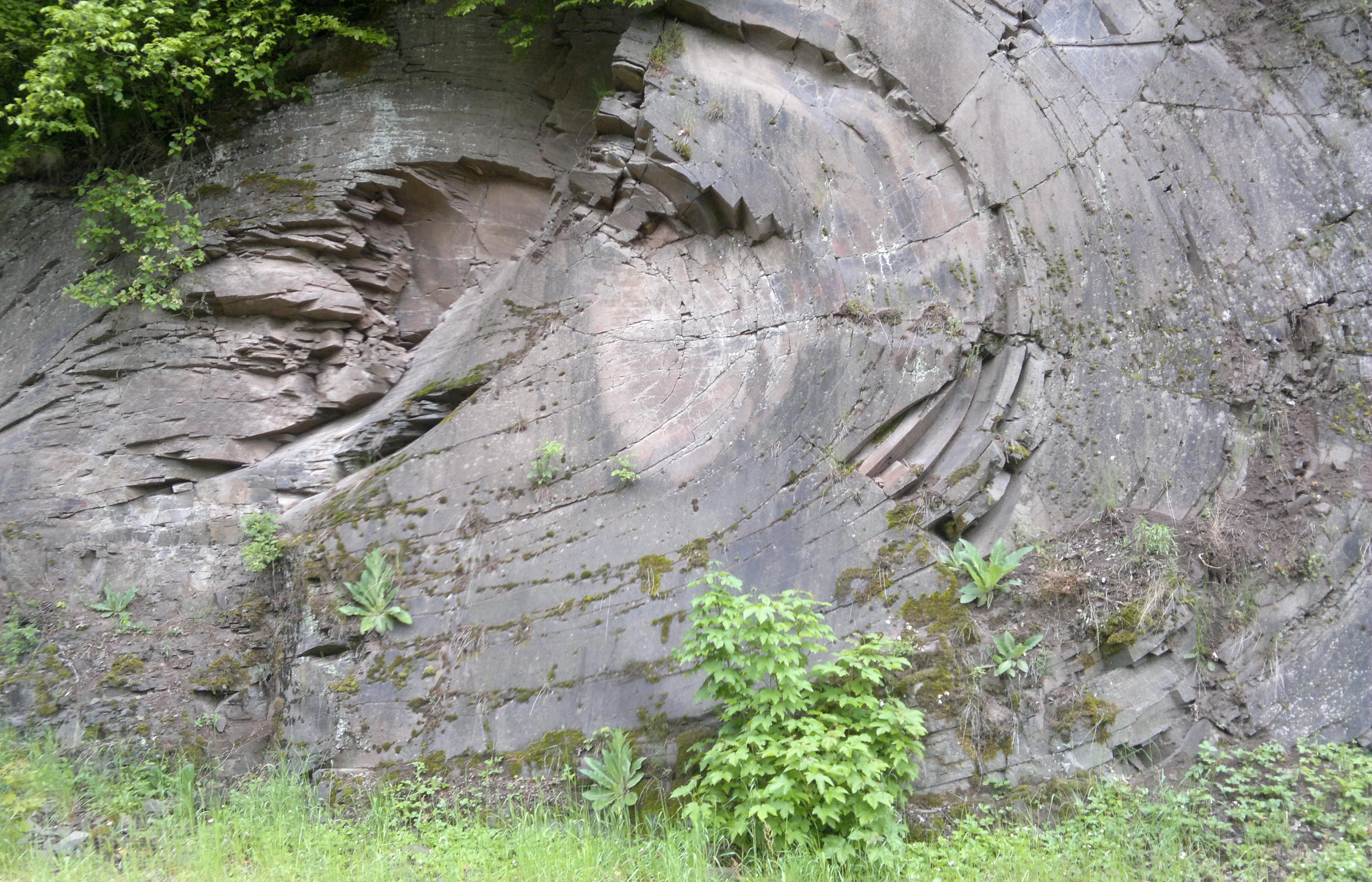
A close up view of a vertical grey rock face showing distinct circular and layered geological formations from a cooled lava flow, with small green plants growing in crevices.
A geological exposure of a cooled lava flow within the Truppenübungsplatz Baumholder training area.

Truppenübungsplatz Baumholder history and protected-area timeline

The origins of Truppenübungsplatz Baumholder reach back to the mid-1930s, when the Wehrmacht began creating the grounds in 1937 for the XII Army Corps of the Army, whose general command was based in Wiesbaden. The formal "Gutsbezirk Baumholder" administrative district was established in 1938, and the construction of the training area required the clearance of entire villages and hamlets, affecting roughly 3,970 residents who were displaced from places such as Aulenbach, Ausweiler, Breungenborn, Ehlenbach, Erzweiler, Frohnhausen, Grünbach, Ilgesheim, Kefersheim, Mambächel, Oberjeckenbach, Ronnenberg, Wickenhof, Wieselbach, and later Zaubach, leaving these settlements as abandoned "Wüstungen" whose former inhabitants still gather annually to remember the communities.

During the Second World War, units of the Wehrmacht trained on the grounds, and Soviet prisoners of war brought from Stammlager VI K (326) in Westphalia were forced into labor details there, with around 450 held in work commandos by late summer 1941. Allied bombing in autumn 1944 damaged barracks, support buildings, and the theater on the site, and in 1945 the United States Army took control before handing the area to the French Army in August 1945, under whose administration it remained until 1960. The US 2nd Armored Division began using the grounds from around 1951 to 1952, and German soldiers returned in 1956 after the founding of the Bundeswehr, which formally took responsibility for the site in 1960.

The Gutsbezirk Baumholder was dissolved on 1 January 1994, with most of its territory going to the town of Baumholder and smaller portions distributed to surrounding municipalities. From 2002 the US Army progressively shifted many of its exercises to the Grafenwöhr and Hohenfels training areas in the Upper Palatinate, while a revised usage concept in 2003 reduced the number of firing ranges. In recent decades Baumholder has gained a parallel identity as a significant refuge for flora and fauna, and although its terrain was explored as a candidate area for a national park in Rhineland-Palatinate, that proposal was ultimately not pursued.

Truppenübungsplatz Baumholder landscape and geographic character

The training area occupies a varied, hilly stretch of landscape south of the Hunsrück, sitting on the transition between the Hunsrück and the North Palatinate Uplands, with the Nahe running past its northwestern edge and the Glan bordering the southern side. The highest and lowest points of the terrain differ by several hundred meters, producing a patchwork of forested ridges, valley slopes, and open plateaus.

Roughly two-thirds of the area is forested, made up of mixed woodland typical of the region, while the remaining open ground takes the form of training meadows, range corridors, and disturbed mineral soil. Many of the former villages that once occupied the valleys were cleared in the late 1930s, so much of the present surface is composed of regrown forest and maintained firing strips rather than long-standing settlement land. In the northern part of the area, near the L 169 road, a former quarry revealed a cooled lava flow that is notable for how well preserved it is, an unusual geological feature for Germany that hints at the deeper volcanic history of the North Palatinate region.

Truppenübungsplatz Baumholder ecosystems, habitats, and plant life

Ecologically, Truppenübungsplatz Baumholder functions as a de facto nature reserve shaped by decades of restricted civilian access and active management. Its setting between two major river valleys and along the Hunsrück/North Palatinate transition zone creates a wide range of habitats, including mixed deciduous and coniferous forest, open heath-like clearings, rocky slopes, and disturbed ground along firing ranges that mimics the open structure of traditional cultural landscapes.

Surveys have recorded 721 species of ferns and flowering plants on the site, of which 27 are listed on the German Red List of threatened species, including legumes such as the grass pea and mosses such as Bryum alpinum. The area also supports unusual dry and semi-dry grassland communities maintained by the open conditions of the ranges, and the combination of forest and open land provides nesting and feeding habitat for a rich insect fauna, with more than 80 species of butterflies documented.

Truppenübungsplatz Baumholder wildlife and species highlights

The combination of restricted access, varied habitats, and large continuous land area has allowed Truppenübungsplatz Baumholder to host an unusually rich fauna. Bird surveys have recorded 104 species, including relatively rare or sensitive breeders such as black storks, woodlarks, and great grey shrikes, reflecting the value of the site's mix of mature forest and open ground.

Mammal life is similarly notable, with established populations of Eurasian lynx and European wildcat, both of which benefit from the quiet, well-connected forest tracts. The presence of so many butterfly species, including rare types like the ringlet, the lilac gold copper, and the thyme blue, also indicates that the area supports complex plant-pollinator networks. Together these features give the training area a wildlife profile that, for many species, is more favorable than that of the surrounding, more heavily used countryside.

Truppenübungsplatz Baumholder conservation status and protection priorities

Although its primary mission is military training, Truppenübungsplatz Baumholder carries significant formal conservation status. Most of the training area lies within the EU Habitats Directive site "Baumholder und Preußische Berge" (designation DE-6310-301) and within the EU Bird Protection Area "Baumholder" (DE-6310-401), placing the bulk of the grounds within the European Natura 2000 network and aligning national defense use with continental biodiversity protection obligations.

The conservation value of the site is widely attributed to decades of restricted civilian access, which has limited habitat fragmentation and kept large blocks of forest and open land intact. The site's biodiversity was strong enough that, in discussions over a possible national park for Rhineland-Palatinate, the area was considered as a candidate, before the proposal was set aside. The combination of Natura 2000 protection, ongoing military management, and the rarity of its preserved lava flow and agate deposits makes Baumholder one of the more distinctive conservation landscapes in Germany.

Truppenübungsplatz Baumholder cultural meaning and human context

The cultural backdrop of Truppenübungsplatz Baumholder is strongly shaped by the displacement of local communities in the late 1930s. Fifteen named villages and hamlets, plus numerous individual farmsteads, were cleared to create the training area, turning formerly inhabited valleys into abandoned settlements. The displaced families and their descendants continue to hold annual gatherings at remembrance markers such as the memorial tablet at the site of former Grünbach, preserving the memory of communities that no longer appear on the modern map.

The area also sits within a region long associated with mining and stone working, and the widespread presence of agates has given parts of Baumholder a quiet reputation among amateur mineralogists, even though the sites themselves cannot be visited without permission. The shared military presence of German, American, and other NATO forces over decades has also made Baumholder a notable node in the postwar military and social history of western Germany.

Top sights and standout views in Truppenübungsplatz Baumholder

Truppenübungsplatz Baumholder stands out as one of the largest active military training areas in Germany while simultaneously functioning as a Natura 2000 site of recognized European conservation value. Its combination of forest, open training ground, and abandoned former village sites has produced an unusually rich habitat for birds, butterflies, wildcats, and lynx.

Among its most distinctive features are the rare, well-preserved exposed lava flow in a former quarry and the area's agate deposits, both of which give the site geological as well as ecological interest. Its role in joint German-American and NATO training since the postwar period, including the only current German training ground that permits tactical air-to-ground exercises from medium and high altitudes, rounds out a profile that blends military, natural, and geological significance in a single landscape.

Best time to visit Truppenübungsplatz Baumholder

Because Truppenübungsplatz Baumholder is an active military installation, public access is restricted and there is no general visitor season in the usual sense. Anyone interested in the area's landscapes, flora, or geology can typically only experience the site from outside its perimeter or through formally permitted visits, so the timing of a visit is dictated by access arrangements rather than by seasonal conditions.

From an ecological perspective, late spring and early summer tend to be the most rewarding periods for wildlife observation along the edges of the area, when breeding birds such as woodlarks and black storks are active and many of the recorded butterfly species are on the wing. For the displaced communities and their descendants, the late summer gatherings at remembrance markers such as the Grünbach memorial provide a focused window into the human history of the landscape.

Monthly climate preview

Long-term representative point measurements tracking monthly temperature and precipitation variation

Truppenübungsplatz Baumholder Climate Normals and Annual Temperature Rhythm

Historical data records mean monthly temperatures ranging from sub-zero winter readings to warm summer maximums alongside consistent year-round precipitation averages. Accessing the complete twelve-month record provides detailed monthly breakdowns for comparative regional analysis.
Annual mean9 °C
0 °C19 °C
Jan
Feb
Mar
Apr
May13°
Jun17°
Jul19°
Aug19°
Sep14°
Oct
Nov
Dec
Warmest month
July

19.2 °C

Coolest month
January

-0.2 °C

Wettest month
December

2.4 mm/day

Driest month
April

1.5 mm/day

Park location guide

Geography guide, regional context, and park location map for Truppenübungsplatz Baumholder

Truppenübungsplatz Baumholder park geography, regions, and map view in Germany

Understand where Truppenübungsplatz Baumholder sits in Germany through a broader geographic reading of the surrounding landscape, nearby location context, and its mapped position within the national park landscape.

How Truppenübungsplatz Baumholder fits into Germany

Germany is a federal republic in Western and Central Europe with a population of over 83 million across sixteen constituent states. It is Europe's largest economy by nominal GDP and a major global exporter and importer. The capital is Berlin, and the country borders Denmark, Poland, Czech Republic, Austria, Switzerland, France, Luxembourg, Belgium, and the Netherlands.

Wider geography shaping Truppenübungsplatz Baumholder in Germany

Germany is located in Western and Central Europe, spanning 357,022 km². It borders Denmark to the north, Poland and the Czech Republic to the east, Austria and Switzerland to the south, and France, Luxembourg, Belgium, and the Netherlands to the west. The country has coastlines on the Baltic Sea and North Sea to the north, with the Alps located in the southern region.

Map view of Truppenübungsplatz Baumholder

Use this park location map to pinpoint Truppenübungsplatz Baumholder in Germany, understand its exact geographic position, and read its mapped placement within the surrounding landscape more clearly.

Pigeon | © OpenStreetMap contributors

Location context for Truppenübungsplatz Baumholder

Rheinland-Pfalz

Visual reference of forested ridges, rare geology, and conservation habitats

Truppenübungsplatz Baumholder Landscape Photos and Protected Area Scenery

Visual documentation captures the diverse terrain, mixed woodland, and protected habitats across Truppenübungsplatz Baumholder. Photographic records reveal the unique intersection of military history, geological features, and established conservation zones.

A close up view of a vertical grey rock face showing distinct circular and layered geological formations from a cooled lava flow, with small green plants growing in crevices.

A wide landscape view of rolling green hills, scattered trees, and dirt tracks intersecting in an open field.

Park atlas

Compare surrounding natural terrain, forest reserves, and conservation areas across the region.

Explore Parks Near Truppenübungsplatz Baumholder and Regional Protected Landscapes

Browsing other parks near Truppenübungsplatz Baumholder reveals broader ecological patterns across the surrounding regional terrain. Comparing these adjacent protected landscapes provides valuable geographical context for the Hunsrück uplands.
A horizontal watercolor painting of rolling green hills, a small stream, and forested slopes against a pale sky.
Protected areaRheinland-Pfalz
About 13 km away#1 closest

Southeast

Königsberg Protected Area: Geography, Forest Habitats, and Regional Landscape Identity

Examining the mountain ridges of the Nordpfälzer Bergland

Königsberg stands as a prominent mountain massif in the German state of Rheinland-Pfalz. This protected landscape is characterized by deep mixed beech-oak forests, significant geological scree formations, and an intricate history of mining. Its ridge-line terrain provides a critical study of upland geography, separating regional valleys while hosting a diverse array of protected natural habitats and medieval heritage sites.

Area
10.47 km²
Relief
Mountain
Climate
Temperate
Access
Moderate access
Watercolor painting of a forested landscape with rolling hills and distant mountains under a pale sky
National parkSaarland
About 17 km away#2 closest

West

Hunsrück-Hochwald National Park: Saarland Protected Area Atlas and Landscape Context

Explore the mapped terrain and protected geography of this German national park.

Delve into the specific geography and protected landscape of Hunsrück-Hochwald National Park in Saarland. This detail page provides an atlas-centric view of the park's mapped boundaries, regional context, and its role as a national park. It serves as a foundational point for understanding the park's landscape features and its placement within the broader geographic atlas.

Area
100 km²
Established
2015
IUCN
II
Relief
Mountain
Watercolor painting of rolling green hills, small forest patches, and rocky outcrops under a soft, white background.
National parkRheinland-Pfalz
About 17 km away#3 closest

West

Nationalpark Hunsrück-Hochwald: An Atlas and Geographic Overview of Protected Lands

Upland forest ecosystems and quartzite mountain terrain

The Hunsrück-Hochwald region showcases the transition of industrial-era forests toward near-natural wilderness. Its mapped territory integrates significant beech wood blocks with smaller wetland systems, reflecting a commitment to long-term biodiversity within the German uplands. Explore the structural composition and landscape features that define this protected zone.

Area
101.2 km²
Established
2015
IUCN
II
Relief
Mountain
A horizontal watercolor illustration depicting rolling green hills, a forest, a winding river, and hazy distant mountains.
Nature reserveRhineland-Palatinate
About 18 km away#4 closest

Northwest

Mörschieder Burr Nature Reserve: Geological Identity and Protected Forest Boundaries in Rhineland-Palatinate

A mapped quartzite summit within the Hunsrück forest landscape.

Spanning nearly 20 hectares, Mörschieder Burr preserves a rare expanse of vegetation-free scree slopes and Taunus quartzite outcrops in western Germany. The reserve acts as a geological anchor within the Idarwald forest, offering a concentrated look at the unique rocky terrain that defines this part of the Hunsrück-Hochwald National Park buffer zone.

Area
0.197 km²
Established
1940
Nature reserveSaarland
About 21 km away#5 closest

Southwest

Südteil des Nohfeldener Rhyolith-Massivs: Saarland Nature Reserve and Volcanic Highland Terrain

Protected montane grasslands and rare bog woodland habitats.

This nature reserve protects 73 hectares of critical habitat within the Saarland uplands. Defined by the rhyolite massif geology between Losenberg and Leißberg, the protected area maintains rare montane mat-grass swards and fragile bryophyte communities. The site serves as a vital example of volcanic landscape conservation, highlighting the intersection of acidic silicate soils and specific ecological biodiversity in Germany.

Area
0.73 km²
Established
2017
IUCN
IV
Nature reserveSaarland
About 24 km away#6 closest

West

Wiesenkomplex bei Eisen Nature Reserve: Geography and Protected Habitat Mapping in Saarland

A mosaic of meadow and riparian stream ecosystems

Located in northern Saarland, Wiesenkomplex bei Eisen protects a mosaic of traditionally managed wet and semi-dry grasslands. The reserve, centered on the Krippbach stream, supports essential floodplain gallery forests and diverse meadow types. This mapping of four non-contiguous sites underscores the role of structured management in preserving remnant cultural landscape habitats within the region.

Area
0.9 km²
Established
2016
IUCN
IV
Relief
Lowland
Nature reserveRhineland-Palatinate
About 24 km away#7 closest

Northwest

Naturschutzgebiet Spring Nature Reserve: Protected Wetland and Headwater Landscape Geography

Mapped upland habitats in the Hunsrück, Rhineland-Palatinate

Naturschutzgebiet Spring protects a specialized wetland complex, featuring headwater streams and peatland formations within the Idarwald. This conservation area highlights the fragile, water-dependent ecology of the Hunsrück, providing a clear geographic view of preserved mire and swamp forest terrain within Rhineland-Palatinate.

Area
0.74 km²
Established
1988
Relief
Upland
Scope
Terrestrial
Nature reserveRhineland-Palatinate
About 25 km away#8 closest

South

Westricher Moorniederung Nature Reserve: Protected Wetland and Moorland Atlas

Mapping low-lying basin landscapes and riparian corridors in the German Palatinate.

Spanning 40 kilometers between the Bliesaue and Kaiserslautern, the Westricher Moorniederung protects an intricate network of bogs, marsh zones, and alluvial forests. This lowland basin acts as a vital ecological link within Rhineland-Palatinate, defined by its drainage systems and diverse mire habitats. Gain insight into the regional geography and protected land boundaries that define this significant wetland system.

Area
21.52 km²
Established
1998
IUCN
IV

Common questions about visiting, size, designation, and location context for Truppenübungsplatz Baumholder

Truppenübungsplatz Baumholder FAQs for park facts, access, geography, and protected area context

Find quick answers about Truppenübungsplatz Baumholder, including protected-area facts, park geography, trail and visitor context, and how the park fits into its surrounding country and regional landscape.
MoriAtlas Explorer

Continue Your Protected Areas Search Across the Global Atlas

Deepen your exploration by continuing the structured search for national parks and protected areas worldwide. Utilize the comprehensive filtering capabilities to compare different conservation landscapes and refine your understanding of global park geography. Discover more about the distribution and characteristics of protected natural areas.

Global natural geography