Mori Atlas logo
Protected landscapeTuskegee National Forest

A compact lowland forest featuring rolling stream terraces and longleaf pine ecosystems in east-central Alabama.

Tuskegee National Forest: Exploring the Protected Landscape and Mapped Geography of Macon County

Tuskegee National Forest serves as a unique protected area within Macon County, notable for its compact footprint and significant role as the smallest national forest in the United States. The terrain is characterized by gently rolling ridges, stream-cut floodplains, and mixed hardwood forests that offer a distinct glimpse into the natural history of the Alabama Black Belt. Through detailed mapping and landscape analysis, this record provides insight into the diverse trail networks and recreational areas that define this approachable southern wilderness.

national forestAlabamaMacon Countypine and hardwood forestBlack Belt landscapestream terraces

Tuskegee National Forest

Protected landscape

Park overview

Structured park overview, official facts, and landscape profile for Tuskegee National Forest

Tuskegee National Forest park facts, protected area profile, and essential visitor context

Review the core facts for Tuskegee National Forest, including designation, size, terrain, visitor scale, habitats, and operating context in one park-focused overview.

About Tuskegee National Forest

Tuskegee National Forest occupies a modest but ecologically meaningful place in east-central Alabama. Located in Macon County, just north of Tuskegee and west of Auburn, it spans roughly 11,252 acres of level to moderately sloping terrain shaped by broad ridges, stream terraces, and broad floodplains. Although it is by far the smallest national forest in the United States, its concentration of trails, recreation areas, and habitat diversity gives it a disproportionately rich presence in the regional outdoor landscape.

The forest is administered by the U.S. Forest Service, with statewide headquarters in Montgomery, the same city that hosts the administrative offices for all four of Alabama's national forests. In addition to its administrative network, Tuskegee has local ranger district offices located in the city of Tuskegee itself, which helps anchor the forest as a community-facing natural area as much as a backcountry destination. Its proximity to two college towns, Tuskegee University and Auburn University, also makes it a familiar outdoor escape for students, faculty, and residents across the region.

Visitors come to Tuskegee National Forest for a wide range of activities that belie its small footprint. Four main hiking trails are available, three of which double as mountain biking routes, and the Bartram Trail passes through the forest as part of its longer regional course. Horse trails, two fish ponds, the Uchee Shooting Range, the Tsinia Wildlife Viewing Area, primitive camping opportunities, and the Taska Recreation Area further broaden what the forest offers. The combination of accessibility, recreational diversity, and ecological setting has established Tuskegee as a quietly important fixture of Alabama's protected land network, especially for those seeking a quick but immersive experience in southeastern pine and hardwood country.

Quick facts and research context for Tuskegee National Forest

Tuskegee National Forest covers roughly 11,252 acres in Macon County, Alabama, and is managed by the U.S. Forest Service. Established on November 27, 1959, it is the smallest national forest in the United States and one of only six contained entirely within a single county.

The forest's terrain is level to moderately sloping, defined by broad ridges, stream terraces, and floodplains. It is headquartered in Montgomery along with Alabama's three other national forests: Conecuh, Talladega, and William B. Bankhead. Local ranger district operations are based in Tuskegee.

Protection and recognition

Examine the terrestrial conservation scope and recognized protected area data.

Tuskegee National Forest Protection Status and Designated Area Record

Tuskegee National Forest maintains a documented terrestrial protection status within national conservation frameworks. Structured preservation records outline the administrative management scope and official designation history for the landscape.

Protection details

Protection scope
Terrestrial
Transboundary protection
No
Park context

Deeper park guide and search-rich context for Tuskegee National Forest

Tuskegee National Forest history, landscape, wildlife, and travel context

Explore Tuskegee National Forest through its history, landscape character, ecosystems, wildlife, conservation priorities, cultural context, and seasonal travel timing in a structured park guide built for atlas discovery and search intent.

Why Tuskegee National Forest stands out

Tuskegee National Forest is best known for being the smallest national forest in the United States, despite offering a full suite of outdoor activities within its compact boundaries. It draws attention for being one of only six national forests contained entirely within a single county, Macon County, Alabama. The forest is also recognized for its portion of the Bartram Trail, its network of multi-use trails for hiking, mountain biking, and horseback riding, and its easy accessibility from Tuskegee and Auburn. Its combination of pine and hardwood cover, stream-cut topography, and recreational amenities makes it a notable, if small, fixture in Alabama's outdoor landscape.
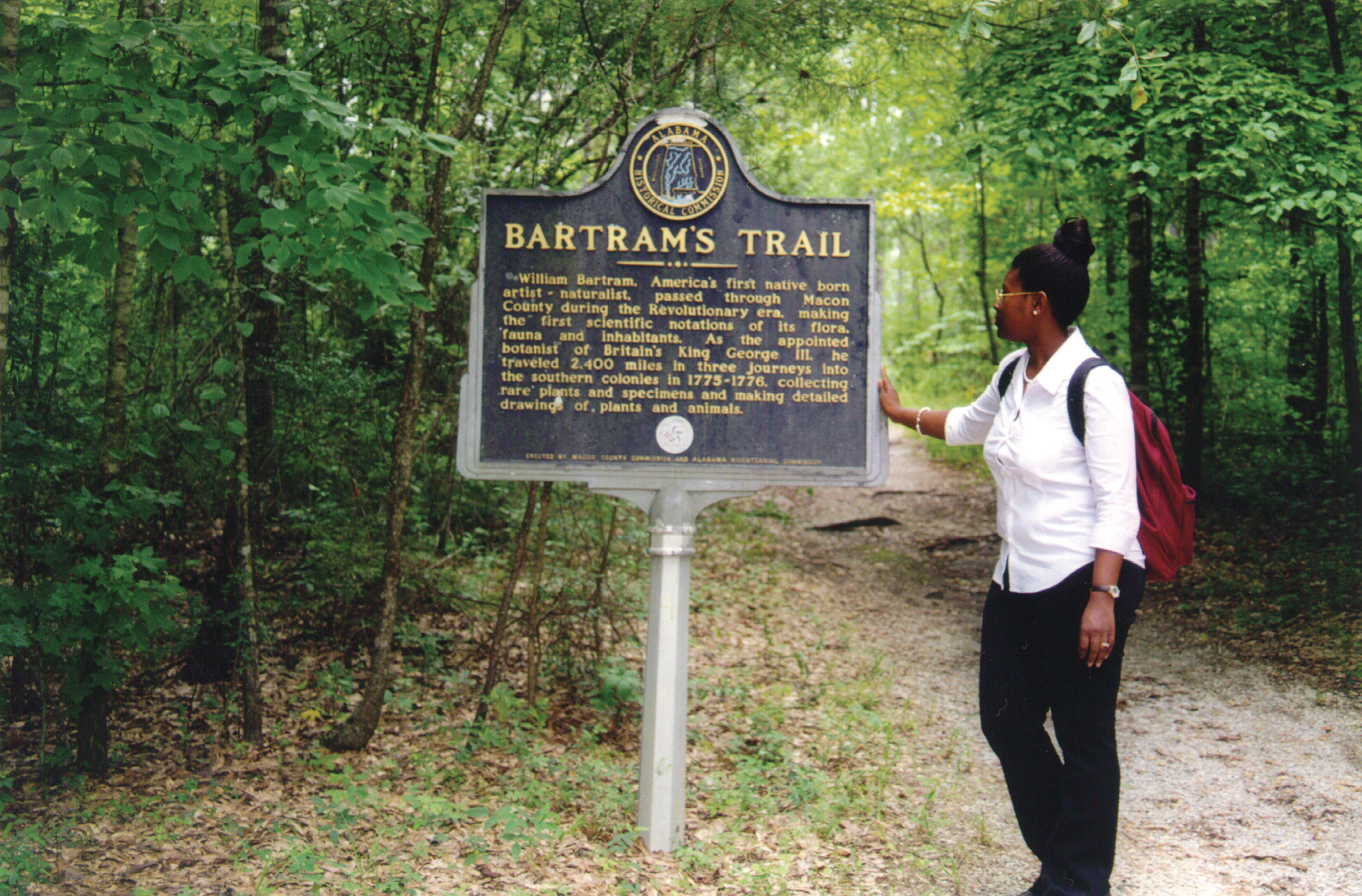
A woman stands on a dirt trail in a wooded area, reading a metal interpretive sign titled Bartram's Trail.
A visitor reads an interpretive historical sign for the Bartram Trail in Tuskegee National Forest.

Tuskegee National Forest history and protected-area timeline

Tuskegee National Forest was officially established on November 27, 1959, becoming the fourth national forest associated with Alabama's Forest Service administration.

From its founding, it was managed alongside the state's other national forests, Conecuh, Talladega, and William B. Bankhead, all of which share statewide headquarters in Montgomery. Locally, ranger district operations have been based in the city of Tuskegee, reflecting the forest's close relationship to the surrounding community even as its administration is integrated into a broader state-level structure.

Because the forest is one of only six national forests in the United States contained entirely within a single county, its history is also bound up with the local land-use patterns of Macon County. Its relatively late establishment compared to many other national forests, combined with its compact footprint, means it has functioned less as a sprawling wilderness reserve and more as a nearby, multi-use natural area serving local residents and visitors from nearby cities such as Tuskegee and Auburn.

Tuskegee National Forest landscape and geographic character

The landscape of Tuskegee National Forest is defined by the gently rolling topography of east-central Alabama. The terrain is level to moderately sloping, characterized by broad ridges that descend gradually into stream terraces and broad floodplains. Rather than dramatic elevation changes or exposed rock formations, the forest's visual rhythm comes from the repetition of these ridges and the network of small streams and valleys that run between them.

The forest's maximum elevation reaches only about 568 feet, a reminder that Tuskegee is firmly a lowland southern forest rather than a mountainous one. The result is a landscape that feels approachable and easy to traverse on foot, with long sightlines through the woods, open understory in many areas, and quiet corridors along the stream margins. This terrain supports the longleaf pine and mixed hardwood vegetation that defines the region, and makes the forest feel like a contiguous, walkable expanse despite its modest acreage.

Tuskegee National Forest ecosystems, habitats, and plant life

Tuskegee National Forest sits within the broader ecological framework of Alabama's Black Belt and east-central Mixed Forest regions. Its mix of broad ridges, stream terraces, and floodplains supports a blend of pine and hardwood cover, with longleaf pine likely playing a historical and ongoing role alongside oaks and other hardwood species typical of the area.

The forest's network of streams and associated floodplains creates important habitat structure, including wetland margins and bottomland environments that contrast with the drier upland ridges. These variations in moisture, soil, and elevation, even within a relatively small area, allow the forest to host a diversity of plant communities and the wildlife that depends on them. The presence of designated wildlife viewing areas, such as the Tsinia Wildlife Viewing Area, underscores the forest's role as a managed habitat where ecological observation is part of the visitor experience.

Tuskegee National Forest wildlife and species highlights

The wildlife profile of Tuskegee National Forest reflects its setting as a small but structurally diverse southern forest. Its mix of upland pines, hardwood stands, streams, and pond environments supports a range of species typical of the Alabama Black Belt and surrounding regions, including songbirds, small mammals, and reptiles associated with both dry ridge tops and moist bottomlands.

The forest's dedicated Tsinia Wildlife Viewing Area suggests an emphasis on observing native fauna in a relatively undisturbed setting. Combined with the two fish ponds and the broader mosaic of habitats, this makes Tuskegee a workable site for casual wildlife watching and birding, even if it is not nationally known for large mammal populations. Its accessibility also means that visitors can encounter forest wildlife without venturing deep into remote terrain.

Tuskegee National Forest conservation status and protection priorities

As one of only six U.S. national forests contained entirely within a single county, Tuskegee National Forest represents a distinctive model of conservation: a compact, county-scale protected landscape rather than a vast wilderness block. Its protection under the U.S. Forest Service ensures that its forests, streams, and associated habitats are managed for long-term ecological health, multiple use, and public benefit.

The forest's mix of pine and hardwood cover, along with its stream terraces and floodplains, gives it conservation value beyond its small size: these habitats support regional biodiversity, contribute to watershed function, and preserve a representative slice of Alabama's historic Black Belt landscape. Its recreational infrastructure, including the Bartram Trail segment and the wildlife viewing area, also reflects an effort to integrate conservation with education and public enjoyment, ensuring that the forest remains both ecologically functional and culturally relevant to nearby communities.

Tuskegee National Forest cultural meaning and human context

Tuskegee National Forest is closely tied to the identity of the city of Tuskegee and the broader east-central Alabama region. Its location just north of Tuskegee and within easy reach of Auburn places it near two communities with deep historical and cultural significance, including the legacy of Tuskegee University and the surrounding Black Belt landscape.

The forest's name and location connect it directly to this regional heritage, while its role as a publicly accessible natural area makes it part of everyday community life for residents of Macon County and visitors from nearby towns. Trails such as the Bartram Trail, which traces the route of the 18th-century naturalist William Bartram through the Southeast, add a layer of historical travel and exploration to the forest's contemporary recreational identity.

Top sights and standout views in Tuskegee National Forest

Tuskegee National Forest's strongest points of distinction include its unusual status as the smallest national forest in the United States and one of only six contained entirely within a single county. Despite its compact size, it offers a dense concentration of recreational opportunities: hiking, mountain biking, horseback riding, fishing, shooting sports, primitive camping, and wildlife viewing.

A segment of the Bartram Trail runs through the forest, linking Tuskegee to a broader legacy of natural history exploration in the Southeast. The Tsinia Wildlife Viewing Area, the Taska Recreation Area, the Uchee Shooting Range, and two fish ponds together provide a multi-use outdoor experience that is unusual for a forest of this scale. Its accessibility from both Tuskegee and Auburn further enhances its role as a convenient yet ecologically rich natural escape in Alabama.

Best time to visit Tuskegee National Forest

Tuskegee National Forest is best experienced in the cooler months of late fall, winter, and early spring, when lower humidity and milder temperatures make its trail networks and recreation areas more comfortable for extended outdoor activity. During these seasons, the leaf-off hardwoods open up longer sightlines through the forest, and wildlife viewing, particularly for birds and other species visible from areas like Tsinia, can be more rewarding.

Spring and early summer bring warmer, more humid conditions typical of the Deep South, accompanied by lush vegetation and increased insect activity. Summer visits are still possible, especially in the early morning or late afternoon, but visitors should expect heat, high humidity, and summer afternoon thunderstorms. Fall foliage, while more subtle than in mountainous regions, adds seasonal character to the broadleaf component of the forest, making autumn a particularly pleasant time for hiking and mountain biking along the Bartram Trail and the forest's other multi-use paths.

Monthly climate preview

Long-term representative temperature and monthly precipitation statistics for Macon County

Tuskegee National Forest Climate Normals and Annual Weather Patterns

Recorded baseline measurements outline the annual temperature range and daily precipitation rhythm across representative coordinates in Tuskegee National Forest. Reviewing the complete twelve-month dataset clarifies long-term climatic trends and provides detailed monthly normals.
Annual mean18 °C
7 °C28 °C
Jan
Feb
Mar13°
Apr17°
May22°
Jun26°
Jul28°
Aug27°
Sep24°
Oct19°
Nov12°
Dec
Warmest month
July

27.6 °C

Coolest month
January

7 °C

Wettest month
February

4.3 mm/day

Driest month
October

2.5 mm/day

Park location guide

Geography guide, regional context, and park location map for Tuskegee National Forest

Tuskegee National Forest park geography, regions, and map view in United States of America

Understand where Tuskegee National Forest sits in United States of America through a broader geographic reading of the surrounding landscape, nearby location context, and its mapped position within the national park landscape.

How Tuskegee National Forest fits into United States of America

The United States of America is a federal presidential republic and one of the world's largest countries by area and population. It consists of 50 states across a vast territory spanning multiple time zones, with its capital in Washington, D.C. and largest city in New York City. The nation has a diverse economy, influential political system, and significant cultural and military presence globally.

Wider geography shaping Tuskegee National Forest in United States of America

The United States occupies a vast territory in North America, bordered by Canada to the north and Mexico to the south. The 48 contiguous states stretch from the Atlantic to the Pacific Ocean, while Alaska occupies the northwestern region and Hawaii is an archipelago in the Pacific. The country encompasses diverse terrain including the Rocky Mountains, Appalachian Mountains, Great Plains, and extensive river systems.

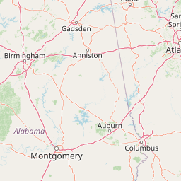
Map view of Tuskegee National Forest

Use this park location map to pinpoint Tuskegee National Forest in United States of America, understand its exact geographic position, and read its mapped placement within the surrounding landscape more clearly.

Pigeon | © OpenStreetMap contributors

Location context for Tuskegee National Forest

Macon County

Visual reference of pine and hardwood habitats, rolling ridges, and stream-cut terrain across Alabama.

Tuskegee National Forest Landscape Photos and Protected Area Scenery

Tuskegee National Forest imagery reveals the distinct lowland terrain, longleaf pine canopy, and quiet stream terraces defining this protected southern landscape. Examining these field photographs helps observers understand the environmental character and compact geography shaping Alabama's smallest national forest.

A woman stands on a dirt trail in a wooded area, reading a metal interpretive sign titled Bartram's Trail.

Park atlas

Discover adjacent protected landscapes and regional forests across east-central Alabama.

Parks Near Tuskegee National Forest and Regional Protected Areas to Compare Next

Browsing other parks near Tuskegee National Forest reveals connected pine ecosystems and low-relief southeastern terrain. Expanding the geographic comparison highlights broader regional protected areas sharing similar natural histories.
Protected landscapeAlabama
About 113 km away#1 closest

Northwest

Talladega National Forest: Geography and Protected Appalachian Forest Maps

Mapping Alabama high country and southern Appalachian forest recovery

Talladega National Forest is a primary protected landscape in Alabama, offering a detailed look at the transition from central pine-oak ridges to northeastern mixed mesophytic hardwood slopes. This forest manages a diverse range of terrain, including the highest peaks in the state, and represents a major achievement in regional ecological restoration across hundreds of thousands of acres of federally protected land.

Area
1,588.66 km²
Established
1936
Relief
Mixed relief
Climate
Temperate
Watercolor painting of a mountain landscape with soft layers of green hills, trees, and a foreground area, rendered in a pale and minimalist style.
Wildlife reserveAlabama
About 150 km away#2 closest

North

Dugger Mountain Wilderness: Mapping Alabama's Appalachian Ridge and Forest Landscapes

Protected mountain terrain and regional Appalachian geography

Dugger Mountain Wilderness acts as a primary anchor for ecological preservation in Alabama. This wildlife reserve preserves over 9,000 acres of steep, roadless ridges near the Appalachian margin. By studying the topographic boundaries and forest cover of this area, observers can better understand the regional mountain characteristics and the critical role this terrain plays in maintaining intact, uninterrupted natural corridors.

Area
37 km²
Established
2000
IUCN
Ib
Relief
Mountain
A pale, soft-focus watercolor painting showing a river with gentle banks and distant hills, with tree branches hanging in the top right corner.
Protected landscapeGeorgia
About 188 km away#3 closest

Northeast

Chattahoochee River National Recreation Area: Protected Landscape Map and Regional Geography

River corridors, Piedmont forest, and historic tributary gorges

This protected landscape in northern Georgia preserves a vital 48-mile corridor along the Chattahoochee River. The terrain shifts from vertical palisade cliffs to wide shoals and forested tributary gorges, weaving through the metropolitan landscape of Atlanta. The area serves as a significant regional anchor for natural river ecosystems and historic industrial remnants.

Area
42.69 km²
Established
1978
IUCN
V
Visitors
3.5M annual
Protected landscapeAlabama
About 220 km away#4 closest

Northwest

William B. Bankhead National Forest: Cumberland Plateau Landscapes and Geography

Protected river gorges and forested ridges in northwestern Alabama

Covering extensive tracts across Lawrence, Winston, and Franklin counties, William B. Bankhead National Forest anchors the regional geography of the Cumberland Plateau. This atlas entry provides a detailed look at the forest's stream-carved terrain, limestone geology, and its central role in preserving the riparian corridors of the Sipsey Fork and its surrounding protected wilderness.

Area
733.4 km²
Established
1918
Relief
Upland
Scope
Terrestrial
A watercolor illustration of a coastal landscape with a sandy shoreline, soft green dunes, and a gentle pink horizon against a white background.
Protected landscapeFlorida
About 247 km away#5 closest

Southwest

Gulf Islands National Seashore: Mapped Landscapes and Protected Coastal Geography

Coastal terrain across Florida, Alabama, and Mississippi.

Spanning diverse units across the Gulf Coast, Gulf Islands National Seashore preserves dynamic barrier islands and mainland reserves. This geographic profile traces the quartz-sand beaches, maritime ecosystems, and historic defense networks that form this protected landscape, providing context on its unique geologic and environmental evolution.

Area
548.179 km²
Established
1971
IUCN
V
Visitors
8.3M annual
A wide watercolor painting showing a landscape of green rolling hills with trees in the foreground and layers of purple mountains in the background against a white background.
Protected areaGilmer County
About 271 km away#6 closest

Northeast

Rich Mountain Wilderness: Mapping Appalachian Ridges and Protected Terrain in Georgia

Explore the high-elevation forests of Gilmer County.

Rich Mountain Wilderness encompasses nearly 9,500 acres of undisturbed Appalachian mountain landscape. Characterized by its signature 4,050-foot peak and unique porter's loam soils, the area supports a diverse forest ecosystem shielded under federal wilderness protection within the Chattahoochee National Forest.

Area
38.35 km²
Established
1986
IUCN
Ib
Relief
Mountain
A soft watercolor illustration depicting a landscape of rolling hills and mountain silhouettes in shades of green, yellow, and faint red against a white background.
Protected landscapeGeorgia
About 273 km away#7 closest

Northeast

Ed Jenkins National Recreation Area and Southern Appalachian Mountain Geography

Protected forested ridges and trail gateway in northern Georgia

Covering over 23,000 acres, this protected area features the iconic southern terminus of the Appalachian Trail at Springer Mountain. The unit preserves a dense tapestry of hardwood forests, rolling ridges, and spring-fed stream valleys, representing a core portion of the Blue Ridge mountain range's continuous landscape in northern Georgia.

Area
94.4 km²
Established
1991
Relief
Mountain
Climate
Temperate
A pale, minimalist watercolor painting showing layers of soft green hills and a gentle stream against a white background.
Wildlife reserveGeorgia
About 294 km away#8 closest

Northeast

Raven Cliffs Wilderness: Exploring the Appalachian Ridges and Protected Forest Landscapes

High-elevation wilderness area in northern Georgia.

Spanning steep ridges and narrow valleys, Raven Cliffs Wilderness represents a significant protected area within the Chattahoochee National Forest. The landscape transitions from high, exposed ridgelines to dense hardwood forest, offering a compact yet varied study in Appalachian mountain geography.

Area
36.89 km²
Established
1986
IUCN
Ib
Relief
Mountain

Common questions about visiting, size, designation, and location context for Tuskegee National Forest

Tuskegee National Forest FAQs for park facts, access, geography, and protected area context

Find quick answers about Tuskegee National Forest, including protected-area facts, park geography, trail and visitor context, and how the park fits into its surrounding country and regional landscape.
MoriAtlas Explorer

Continue Your Protected Areas Search Across the Global Atlas

Deepen your exploration by continuing the structured search for national parks and protected areas worldwide. Utilize the comprehensive filtering capabilities to compare different conservation landscapes and refine your understanding of global park geography. Discover more about the distribution and characteristics of protected natural areas.

Global natural geography