

Mori Atlas logo
Nature reserveTygerberg Nature Reserve

Mapping the ecological significance and terrain of a unique Renosterveld nature reserve

Tygerberg Nature Reserve: A Protected Shale Ridge and Botanical Landscape in Cape Town

Tygerberg Nature Reserve protects a distinct seven kilometer shale ridge within the northern suburbs of Cape Town, South Africa. This nature reserve serves as an essential repository for Swartland Shale Renosterveld, a critically threatened vegetation type characterized by ancient heuweltjie mounds. The geography integrates rolling hill terrain with emerging wetland habitats at the nearby Plattekloof Dam, providing a vital study of urban conservation and endemic plant survival.

urban nature reserverenosterveldSwartland Shale Renosterveldshrublandendemic plantsthreatened vegetation

Tygerberg Nature Reserve

Nature reserve

Park overview

Structured park overview, official facts, and landscape profile for Tygerberg Nature Reserve

Tygerberg Nature Reserve park facts, protected area profile, and essential visitor context

Review the core facts for Tygerberg Nature Reserve, including designation, size, terrain, visitor scale, habitats, and operating context in one park-focused overview.

About Tygerberg Nature Reserve

Tygerberg Nature Reserve is a compact but ecologically important protected area managed by the City of Cape Town. It lies on the southern end of the Tierberg range, a chain of low hills forming a backdrop to the northern suburbs of Cape Town. Despite its modest size of about 300 hectares, the reserve protects a vegetation type that has been almost entirely lost elsewhere in the region.

The reserve's landscape is shaped by the underlying shale geology of the Cape region. Slopes and ridges support a dense cover of renosterveld vegetation, dotted with the characteristic heuweltjie mounds that have become synonymous with this environment. The hills rise gently above surrounding suburbs, with urban development pressing close along several sides, including the N1 highway corridor at the southern limit of the ridge. Despite this urban setting, the reserve retains botanical communities of national significance.

Ecologically, Tygerberg Nature Reserve represents a textbook example of how small, strategically positioned protected areas can serve as refuges for fragmented habitats. The Swartland Shale Renosterveld found here is recognized as highly threatened, and the reserve's plant inventory includes threatened species, Cape Town endemics, and a small group of plants recorded only within the reserve itself. The combination of rich flora, varied terrain, and accessible location reinforces the reserve's role as both a biodiversity sanctuary and an educational resource.

The reserve also connects with broader landscape features beyond its formal boundary. The Plattekloof Dam, located just west of the hills, is undergoing restoration toward a more natural wetland condition, adding aquatic and wetland habitat value to the Tygerberg area. Together with the Kristo Pienaar Environmental Education Centre, these features make the reserve a multifaceted site with ecological, educational, and community significance.

Quick facts and research context for Tygerberg Nature Reserve

Tygerberg Nature Reserve covers approximately 300 hectares of low hill country in the northern suburbs of Cape Town. It lies within the southern end of the Tierberg range, a historically known ridge once called Tijgerberghen and Luipaerts Berghen by early European settlers in the Cape. The reserve was formally established in 1973 and is managed by the City of Cape Town.

Its principal ecological value lies in protecting Swartland Shale Renosterveld, one of the most threatened vegetation types in the Cape Floristic Region. The reserve is home to nearly five hundred plant species, including several that are threatened, several endemic to Cape Town, and a small group that occur nowhere else outside the reserve itself. The site also supports more than a hundred bird species and a range of small mammals, reptiles, and amphibians.

Protection and recognition

Documented terrestrial conservation scope and official recognition details

Tygerberg Nature Reserve Protection Status and Territorial Designation Facts

Terrestrial protection status and administrative management parameters define the conservation scope of Tygerberg Nature Reserve within regional geography. Documented designation records establish official boundaries without incorporating unverified international programs.

Protection details

Protection scope
Terrestrial
Transboundary protection
No
Park context

Deeper park guide and search-rich context for Tygerberg Nature Reserve

Tygerberg Nature Reserve history, landscape, wildlife, and travel context

Explore Tygerberg Nature Reserve through its history, landscape character, ecosystems, wildlife, conservation priorities, cultural context, and seasonal travel timing in a structured park guide built for atlas discovery and search intent.

Why Tygerberg Nature Reserve stands out

Tygerberg Nature Reserve is best known for safeguarding a rare and ecologically critical fragment of Swartland Shale Renosterveld within an urban setting. This shale-based renosterveld is characterized by distinctive circular mounds called heuweltjies, which are believed to be ancient fossilized termite structures and which give the ridge its spotted, leopard-like appearance from a distance. The reserve is also recognized for the unusually high concentration of plant species packed into a small area, including multiple threatened taxa and several that exist only within its boundaries. Its combination of botanical rarity, accessible location on the edge of Cape Town, and established environmental education facilities makes it a distinctive example of a small reserve with disproportionately significant conservation value.
Aerial view of Tygerberg Hill and surroundings
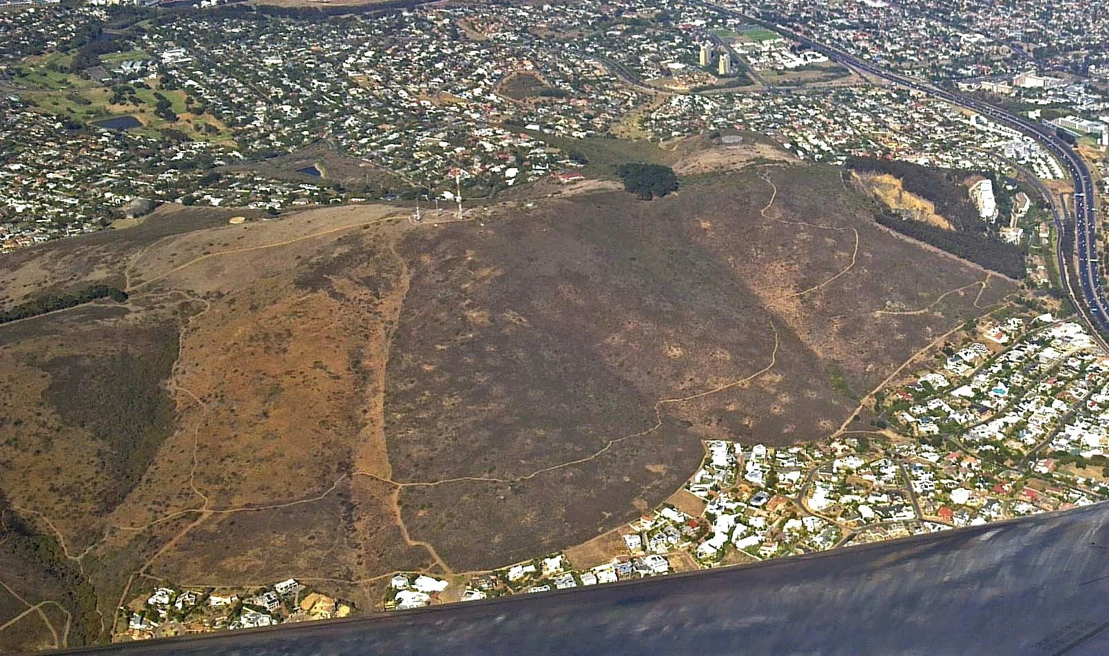
Aerial view of Tygerberg Hill showing the Tygerberg Nature Reserve, adjacent Cape Town suburbs, the N1 highway, and the Sentech Transmission Site.

Tygerberg Nature Reserve history and protected-area timeline

The hills on which Tygerberg Nature Reserve sits have a long documented history in the Cape. As early as 1657, Dutch settlers referred to the seven-kilometer range as Luipaerts Berghen, or Leopard's Mountain, a name inspired by the conspicuous circular patches visible on the slopes. These patches, later understood as heuweltjies, were interpreted by early observers as resembling the spotted coat of a leopard.

By 1661, the range had acquired the name Tijgerberghen, meaning Tiger Mountain. In the Cape Dutch usage of the time, the word tijger referred to a leopard rather than the animal known in modern English as a tiger. The name Tygerberg is a later evolution of this historical designation, and the modern reserve takes its name from these earlier references.

Modern protection of the southern portion of the range began in 1973, when the area was formally established as Tygerberg Nature Reserve. Since then, the site has been managed as a municipal nature reserve under the City of Cape Town, with an emphasis on conserving its shale renosterveld vegetation and providing environmental education opportunities for surrounding communities. The development of the Kristo Pienaar Environmental Education Centre on the reserve added a long-term educational dimension to its protected status, and the subsequent restoration work around Plattekloof Dam has expanded its ecological footprint into the surrounding area.

Tygerberg Nature Reserve landscape and geographic character

The landscape of Tygerberg Nature Reserve is defined by a low ridge of shale hills that forms part of the Tierberg range in the northern part of Cape Town. The hills extend in a roughly linear band approximately seven kilometers long, with the reserve protecting the southernmost section of this chain. The terrain consists of gently sloping ridges and shallow valleys, giving the area a rolling rather than mountainous character.

One of the most distinctive surface features of the landscape is the abundance of heuweltjies, the circular earthy mounds that punctuate the slopes. These mounds occur widely across the surrounding Swartland Shale Renosterveld and contribute to the patchy, spotted appearance of the hills when viewed from a distance. The visual impression of leopard-like markings observed by seventeenth-century settlers is closely tied to this geological and biological feature.

To the west of the hills lies the Plattekloof Dam, a water feature that adds hydrological variety to the local landscape. As the dam area undergoes restoration toward a more natural wetland state, the broader visual character of the Tygerberg area is becoming more diverse, integrating upland ridges with lowland wetland habitat. The reserve's landscape thus combines shale ridges, renosterveld slopes, and emerging wetland margins within a single, compact geographic setting.
Tygerberg Nature Reserve landscape
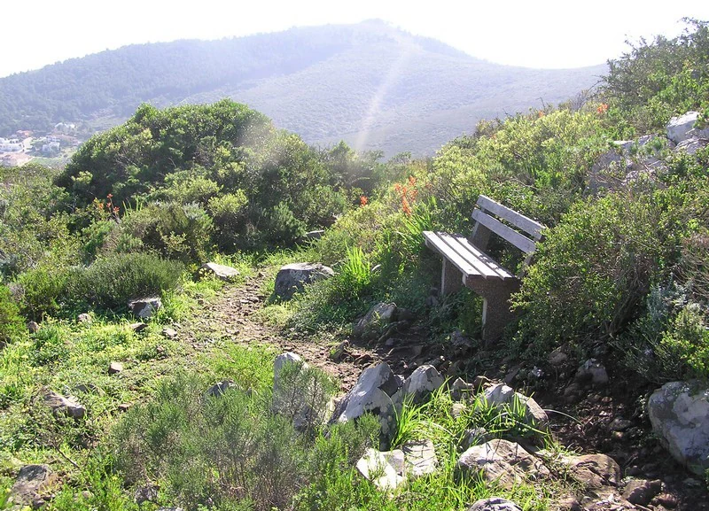
A view of the Tygerberg Nature Reserve located in the Tygerberg Hills of Cape Town.

Tygerberg Nature Reserve ecosystems, habitats, and plant life

The nature of Tygerberg Nature Reserve is centered on Swartland Shale Renosterveld, a vegetation type found primarily on shale-derived soils in parts of the Western Cape. Renosterveld is a low, shrub-dominated plant community known for its resilience and its high botanical diversity, particularly during the flowering season when many bulbs, herbs, and small shrubs come into bloom.

The reserve protects one of the few surviving intact examples of this particular shale variant of renosterveld. As a result, the site harbors a remarkable concentration of plant species, with nearly five hundred different taxa having been recorded here. This figure is especially striking given the reserve's modest size and its location within a heavily urbanized metropolitan setting. The presence of multiple threatened plant species, several plants endemic to Cape Town, and a small subset of plants believed to exist nowhere outside the reserve underscores the conservation importance of the site's botanical communities.

Beyond the vegetation itself, the reserve's natural character includes a range of habitat types that support diverse fauna. The mosaic of shale slopes, heuweltjie mounds, and expanding wetland margins around Plattekloof Dam offers environments for birds, small mammals, reptiles, and amphibians. Together, these habitats form an ecological patchwork that is unusual to find so close to a major urban center.

Tygerberg Nature Reserve wildlife and species highlights

Tygerberg Nature Reserve supports a notably diverse community of wildlife for a small urban reserve. More than a hundred bird species have been recorded here, reflecting the variety of habitats provided by the shale slopes, shrubby renosterveld vegetation, heuweltjie mounds, and the wetland influence of nearby Plattekloof Dam. The mosaic of habitats supports both resident and seasonal bird visitors.

In addition to rich birdlife, the reserve hosts a variety of small wild mammals, including species adapted to renosterveld and fynbos-like environments. Reptiles and amphibians are also present, taking advantage of the rocky outcrops, soil mounds, and seasonal moisture patterns of the hillside terrain. Together with the reserve's exceptionally rich flora, this faunal diversity reinforces its importance as a refuge for native species within an otherwise heavily developed landscape.

Tygerberg Nature Reserve conservation status and protection priorities

Tygerberg Nature Reserve has substantial conservation significance because it preserves one of the last remaining fragments of Swartland Shale Renosterveld, a vegetation type that has been extensively lost to agricultural conversion and urban expansion across the Cape region. For a vegetation type already recognized as highly threatened, the survival of an intact representative area in a major city is especially valuable.

Conservation importance is heightened by the reserve's exceptional botanical richness. Twelve plant species recorded in the reserve are threatened with extinction, eight are endemic to Cape Town, and three are so far known only from within the reserve's own boundaries. These patterns indicate that Tygerberg is not simply a remnant of a broader ecosystem but a unique reservoir of plant diversity that cannot be replaced elsewhere.

Conservation efforts at Tygerberg extend beyond the strict reserve boundary. The restoration of the Plattekloof Dam site toward a functioning natural wetland broadens the ecological scope of protection in the area, linking aquatic and terrestrial habitats. The reserve also plays an important role in environmental education through the Kristo Pienaar Environmental Education Centre, helping to build long-term public support for renosterveld conservation and broader biodiversity awareness in the region.

Tygerberg Nature Reserve cultural meaning and human context

Tygerberg Nature Reserve has a long-standing place in the cultural memory of the Cape, having been named and described by European settlers from the mid-seventeenth century onward. The original Dutch-era names, Luipaerts Berghen and Tijgerberghen, reflect how early colonists interpreted the unusual spotted appearance of the hills, an interpretation that has since informed modern botanical understanding of the heuweltjie phenomenon.

In the present day, the reserve sits within an urban cultural landscape, surrounded by suburbs such as Plattekloof, Welgemoed, and other northern Cape Town neighborhoods. Its role as a gathering point for environmental education, including school excursions and community learning through the Kristo Pienaar Environmental Education Centre, makes it a meaningful local institution beyond its purely ecological value.

Top sights and standout views in Tygerberg Nature Reserve

Tygerberg Nature Reserve stands out for its combination of remarkable botanical density, threatened renosterveld habitat, and accessible urban location. The presence of hundreds of plant species, including several threatened and locally endemic taxa, makes the reserve a small but powerful contributor to Cape Town's plant diversity. The visible heuweltjie landscape adds cultural and visual depth, linking modern ecology with the area's seventeenth-century origins.

The reserve's expanding ecological role, including the wetland restoration at Plattekloof Dam and the on-site environmental education centre, ensures that Tygerberg functions as both a conservation area and a public-facing learning space. It offers a clear example of how modest reserves embedded in cities can still play an outsized role in protecting globally significant vegetation types.

Best time to visit Tygerberg Nature Reserve

The reserve's shale renosterveld environment is most visually rewarding when winter rainfall has recharged the landscape and stimulated fresh growth and seasonal flowering. Cooler, wetter months typically bring greener vegetation and active growth among the reserve's many bulb and herb species, while milder periods during spring are often associated with peak displays of renosterveld flora.

Hotter, drier summer months can leave the vegetation parched and less floriferous, though the reserve remains open and offers good conditions for birdwatching and for walking the trail network. For visitors interested in plant diversity and the characteristic appearance of the heuweltjie-covered slopes, visiting during the cooler, greener months generally provides the richest experience.
Monthly climate preview

Long-term monthly temperature and precipitation data recorded at a representative coordinate

Tygerberg Nature Reserve Climate Normals and Annual Temperature Patterns

Representative coordinates track measured monthly temperature ranges alongside daily precipitation averages from 1991 through 2020. Examining the complete twelve-month record reveals broader annual climate rhythms across the protected area.
Annual mean17 °C
12 °C22 °C
Jan21°
Feb22°
Mar20°
Apr18°
May15°
Jun13°
Jul12°
Aug12°
Sep13°
Oct16°
Nov18°
Dec20°
Warmest month
February

21.6 °C

Coolest month
July

11.8 °C

Wettest month
June

4.1 mm/day

Driest month
February

0.5 mm/day

Park location guide

Geography guide, regional context, and park location map for Tygerberg Nature Reserve

Tygerberg Nature Reserve park geography, regions, and map view in South Africa

Understand where Tygerberg Nature Reserve sits in South Africa through a broader geographic reading of the surrounding landscape, nearby location context, and its mapped position within the national park landscape.

How Tygerberg Nature Reserve fits into South Africa

South Africa is the southernmost country in Africa, spanning 1.22 million km² with a population of over 63 million. The country operates with three capital cities, Pretoria (executive), Cape Town (legislative), and Bloemfontein (judicial), and is renowned for its biodiversity, national parks, and multicultural society.

Wider geography shaping Tygerberg Nature Reserve in South Africa

South Africa occupies the southernmost region of Africa, with coastline along both the Atlantic Ocean to the west and the Indian Ocean to the east. The interior features elevated plateaus including the Highveld, with the Drakensberg escarpment marking the eastern highlands. The country shares borders with Namibia, Botswana, Zimbabwe, Mozambique, Eswatini, and Lesotho.

Map view of Tygerberg Nature Reserve

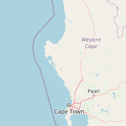
Use this park location map to pinpoint Tygerberg Nature Reserve in South Africa, understand its exact geographic position, and read its mapped placement within the surrounding landscape more clearly.

Pigeon | © OpenStreetMap contributors

Visualizing the shale ridges, renosterveld vegetation, and protected terrain of Tygerberg Nature Reserve

Tygerberg Nature Reserve Photos and Landscape Scenery

Visual records illustrate the rolling shale ridges and rare renosterveld habitats that define Tygerberg Nature Reserve. Examining field photographs reveals the distinctive surface mounds and wetland margins shaping this protected urban landscape.

Aerial view of Tygerberg Hill and surroundings

Swartland Shale Renosterveld vegetation

Tygerberg Nature Reserve landscape

Park atlas

Compare regional shrublands, native vegetation fragments, and protected landscapes

Explore Parks Near Tygerberg Nature Reserve and Surrounding Protected Areas

Continue browsing other parks near Tygerberg Nature Reserve to examine similar botanical landscapes across the region. Comparing adjacent protected areas reveals the broader geographic distribution of threatened renosterveld habitats.
National parkWestern Cape
About 14 km away#1 closest

Southwest

Table Mountain National Park: Mapped Protected Landscape and Geographic Context in Western Cape

National Park details focused on atlas exploration and regional geography.

Table Mountain National Park is a designated national park within the Western Cape region, offering a distinct geographic profile for atlas exploration. This entity provides detailed mapped boundaries and landscape context, crucial for understanding its role as a protected area in South Africa. Users can explore the specific geography that defines this park and its place within the broader regional context, making it a key point of interest for structured geographic discovery and map-based research.

Area
221 km²
Established
1998
Relief
Mountain
Climate
Mediterranean
Nature reserveWestern Cape
About 30 km away#2 closest

Northwest

Koeberg Nature Reserve: A Geographical Overview of Coastal Protected Landscapes

Lowland fynbos, dune thicket, and aquifer geography in the Western Cape

Situated north of Cape Town, Koeberg Nature Reserve acts as a vital sanctuary for threatened plant communities and diverse bird populations. Its unique terrain combines sandy coastal dunes with seasonal pans and wetland complexes, providing a distinct study in protected area conservation and regional ecological management.

Area
26.81 km²
Established
1991
Relief
Lowland
Climate
Mediterranean
Nature reserveWestern Cape
About 33 km away#3 closest

East

Jonkershoek Nature Reserve: A Detailed Atlas of Mountain Catchment and Fynbos Ecology

Protected mountain geography near Stellenbosch, Western Cape

Jonkershoek Nature Reserve serves as a primary water source for the surrounding Western Cape landscape. This profile outlines the reserve's role in the Cape Floral Region, detailing its complex mountain topography, river headwaters, and significant fynbos plant communities that characterize the terrain.

Area
110 km²
Relief
Mountain
Climate
Mediterranean
Access
Easy access
Biosphere reserveWestern Cape
About 38 km away#4 closest

Southwest

Cape Floristic Region: A Detailed Geographic Atlas of the Western Cape Biodiversity Hotspot

Mapped protected biosphere reserve and fynbos landscapes

Explore the Cape Floristic Region, an expansive protected landscape within South Africa. This atlas provides a detailed look at the region's Mediterranean shrublands, sandstone-derived soil terrain, and its status as a singular floral kingdom. Understand the geography of the Western Cape through its mountain ranges and diverse ecological zones.

Area
78,555 km²
Established
2004
Biosphere reserveWestern Cape
About 40 km away#5 closest

East

Cape Winelands Biosphere Reserve: Geographic Overview and Protected Area Mapping

Western Cape mountain terrain and sustainable landscape integration

The Cape Winelands Biosphere Reserve serves as a model for integrated landscape management in South Africa. Situated along the Cape Fold Belt, this reserve protects crucial water catchments and endemic floral habitats while encompassing a globally recognized wine-producing region. Access detailed mapping of its core, buffer, and transition zones to see how conservation persists within a working agricultural environment.

Area
1,243.4 km²
Established
2007
Relief
Mountain
Climate
Mediterranean
Nature reserveWestern Cape
About 54 km away#6 closest

Southeast

Kogelberg Nature Reserve: Protected Mountain Geography in the Western Cape, South Africa

Coastal mountain fynbos and protected river ecosystems

Situated in the Western Cape of South Africa, Kogelberg Nature Reserve protects an exceptional concentration of fynbos vegetation and rugged sandstone terrain. The area spans coastal mountain ridges, riparian corridors, and forest-filled ravines, serving as a landmark for botanical diversity and protected-landscape mapping in the region.

Area
30 km²
Relief
Mountain
Scope
Terrestrial
Water
Major water bodies
Nature reserveWestern Cape
About 67 km away#7 closest

Northwest

Dassen Island Nature Reserve: Atlantic Geography and Protected Area Overview

Coastal refuge and protected granite-based Atlantic island

Located in the cold waters off the Western Cape, Dassen Island is a proclaimed nature reserve and Ramsar wetland. This flat Atlantic landmass is characterized by its granitic reef structure and long-established role as a sanctuary for African penguins and other seabird populations. The island represents a convergence of maritime history and marine conservation, offering a unique geographic perspective on South Africa's coastal wilderness.

Area
2.6 km²
Established
2019
Relief
Lowland
Climate
Mediterranean
National parkWestern Cape
About 74 km away#8 closest

Northwest

West Coast National Park: A National Park's Mapped Boundaries and Geographic Identity

Explore its protected landscape within the Western Cape region.

West Coast National Park is a protected national park situated in the Western Cape province of South Africa. This dedicated page provides a structured view of its geographic scope, emphasizing its mapped boundaries and its significance as a protected landscape within the region's broader atlas context. Gain insight into the park's distinct natural terrain and regional geography.

Area
362.59 km²
Established
1985
Climate
Mediterranean
Access
Easy access

Common questions about visiting, size, designation, and location context for Tygerberg Nature Reserve

Tygerberg Nature Reserve FAQs for park facts, access, geography, and protected area context

Find quick answers about Tygerberg Nature Reserve, including protected-area facts, park geography, trail and visitor context, and how the park fits into its surrounding country and regional landscape.
MoriAtlas Explorer

Continue Your Protected Areas Search Across the Global Atlas

Deepen your exploration by continuing the structured search for national parks and protected areas worldwide. Utilize the comprehensive filtering capabilities to compare different conservation landscapes and refine your understanding of global park geography. Discover more about the distribution and characteristics of protected natural areas.

Global natural geography