
Mori Atlas logo
Protected landscapePřírodní park Údolí Bílého potoka

A deep look at the mapped stream corridor and undulating upland terrain near Brno

Přírodní park Údolí Bílého potoka Protected Landscape and Forested Valley Geography

Přírodní park Údolí Bílého potoka encompasses a distinct 15-kilometer forested valley that cuts through the undulating plateau of the Brno-venkov District. This protected landscape is defined by its vertical relief, featuring steep rocky slopes alongside remnant beech-fir stands and riparian habitats. The geographic structure provides a continuous wooded corridor that stands in contrast to the surrounding agricultural countryside of the South Moravian Region.

nature parkforested valleystream valleybeech-fir forestoak-pine forestrocky slopes
A flat-style digital illustration showing a winding river leading toward a waterfall cascading down a large rocky cliff face, surrounded by pine trees and deciduous trees in a vibrant color palette.

Přírodní park Údolí Bílého potoka

Protected landscape

Park overview

Structured park overview, official facts, and landscape profile for Údolí Bílého potoka Nature Park

Údolí Bílého potoka Nature Park park facts, protected area profile, and essential visitor context

Review the core facts for Údolí Bílého potoka Nature Park, including designation, size, terrain, visitor scale, habitats, and operating context in one park-focused overview.

About Údolí Bílého potoka Nature Park

Údolí Bílého potoka Nature Park is one of several nature parks in the South Moravian Region, established to protect a distinct, ecologically valuable slice of landscape north of Brno. The protected area centers on the valley of Bílý potok, a right-bank tributary of the Svratka, whose lower course cuts through a gently rolling plateau before descending to the small town of Veverská Bítýška, where the stream meets the Svratka.

The park's defining feature is its linear character: about 15 kilometers of valley, mostly wooded and in places rocky, framed by upland ridges that rise to nearly 500 meters. The upper stream corridor rests around 430 meters in elevation, while the lowest point of the protected area lies in the stream's alluvial floodplain just before Veverská Bítýška. This configuration creates a relatively narrow but continuous protected corridor that links elevated forest habitats to lowland riparian environments.

Beyond its scenic and ecological role, the park functions as a buffer of forest and natural habitat within a heavily agricultural region. Originally declared as a quiet zone in 1978, it was upgraded to the přírodní park classification in 1992, reflecting its broader landscape and ecological significance rather than just its value as a retreat from noise and disturbance.

Quick facts and research context for Údolí Bílého potoka Nature Park

Údolí Bílého potoka Nature Park covers about 40 square kilometers in the Brno-venkov district, northwest of Brno. It was first designated on 1 January 1978 as a protected quiet area and was reclassified as a přírodní park (nature park) in 1992.

The park protects a roughly 15 kilometer long forested valley along the lower course of Bílý potok, before the stream joins the Svratka at Veverská Bítýška. Elevation ranges from roughly 430 meters on the upper stream course to nearly 500 meters on the highest surrounding terrain, with the lowest point at the stream's floodplain near the town.

Protection and recognition

Documented terrestrial protection scope and 1992 designation timeline details

Přírodní park Údolí Bílého potoka Protection Status and Designation History

Terrestrial protection status for Přírodní park Údolí Bílého potoka traces its official designation history back to 1992. Structured records assemble verified management scope and conservation baseline facts for comprehensive geographic analysis.

Protection details

Protection scope
Terrestrial
Designated year
1992
Transboundary protection
No
Park context

Deeper park guide and search-rich context for Údolí Bílého potoka Nature Park

Údolí Bílého potoka Nature Park history, landscape, wildlife, and travel context

Explore Údolí Bílého potoka Nature Park through its history, landscape character, ecosystems, wildlife, conservation priorities, cultural context, and seasonal travel timing in a structured park guide built for atlas discovery and search intent.

Why Údolí Bílého potoka Nature Park stands out

Údolí Bílého potoka Nature Park is best known for its long, forested valley running through the South Moravian countryside, framing the lower course of the Bílý potok stream. The valley combines closed woodland, locally rocky slopes, and a quiet upland plateau setting that contrasts with the agricultural lowlands surrounding it. The park is also notable for its forest composition, including well-preserved beech-fir forest belts on steeper, less accessible terrain, alongside pine and spruce stands shaped by historical management.
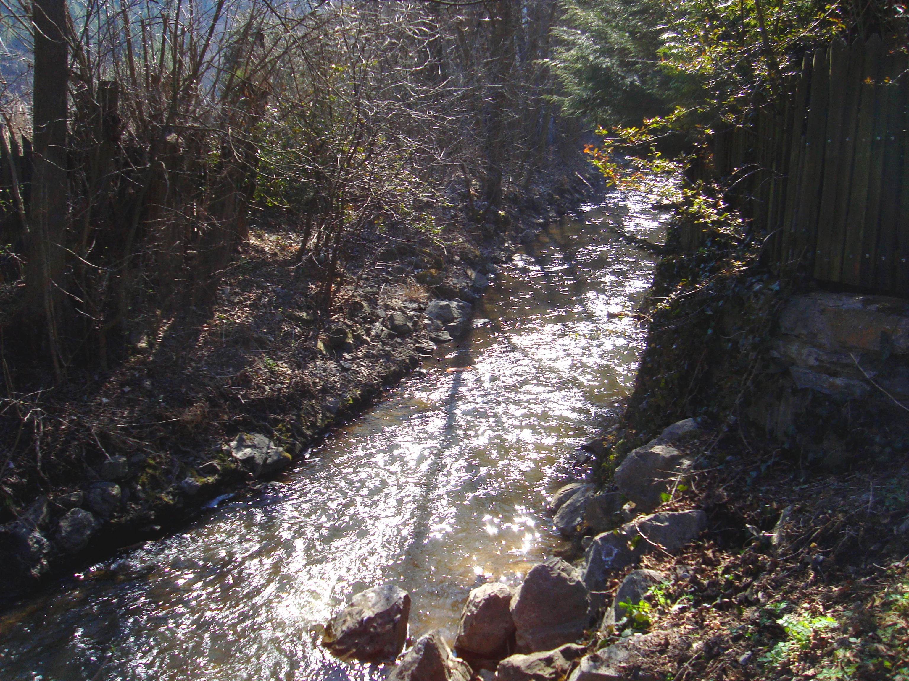
A narrow, sunlit stream flows through a wooded valley with rocky banks and trees along the sides.
The Bílý potok stream flowing through the Smelcovna area.

Údolí Bílého potoka Nature Park history and protected-area timeline

The area now known as Údolí Bílého potoka Nature Park was first protected on 1 January 1978, when it was declared as an area of silence, an obecně chráněné území designation used at the time in Czechoslovakia to protect quiet landscapes of natural or recreational value.

In 1992, following changes in Czech nature conservation law after the dissolution of Czechoslovakia, the area was reclassified as a přírodní park, or nature park. This new status expanded the scope of protection to include the broader landscape and ecological values of the valley, not only its qualities as a quiet rural retreat.

More recent decades have brought new ecological pressures. In 2018, a major drought and subsequent bark beetle outbreak caused significant damage to the spruce stands within the park, a pattern that has affected many Czech forests in the same period. This has highlighted the long-term influence of historical planting practices, which increased the share of spruce and pine at the expense of naturally occurring broadleaf species.

Údolí Bílého potoka Nature Park landscape and geographic character

The landscape of Údolí Bílého potoka Nature Park is defined by a long, narrow valley that cuts through a gently undulating plateau northwest of Brno. This combination of a confined valley and broader surrounding uplands gives the park a layered relief, with the valley floor sitting noticeably below the surrounding ridges.

Along the upper course of Bílý potok, the stream runs at around 430 meters in elevation, while the highest points of the protected area reach close to 500 meters. As the stream descends toward the Svratka, the valley broadens into a lowland floodplain just outside Veverská Bítýška, forming the lowest point of the park. The slopes along this descent are often steep and rocky, especially in stretches less altered by human activity.

The transition between valley and plateau creates a clear visual structure: forested slopes rising to rounded upland summits, broken occasionally by rocky outcrops and stream incisions. Despite being relatively close to Brno, the area retains a strongly rural and wooded character, providing a continuous stretch of natural landscape within the agricultural Moravian countryside.

Údolí Bílého potoka Nature Park ecosystems, habitats, and plant life

Ecologically, Údolí Bílého potoka Nature Park is defined by its forest cover and the gradient between valley and plateau habitats. The wooded slopes of the Bílý potok valley are arranged in two main vegetation belts: a lower oak-pine zone and, more prominently, a beech-fir zone that occupies much of the valley's steeper, less accessible terrain.

In areas where human access has been limited, the beech-fir forests retain a relatively natural character, with composition and structure shaped more by site conditions than by management. Historical forestry practices, however, shifted the balance of species in other parts of the park, increasing the share of Norway spruce and Scots pine at the expense of broadleaf trees such as oak and beech. This management legacy means that the present forest cover is a mix of natural-looking stands and plantations, particularly on more accessible slopes.

Periodic ecological pressure has come from large-scale disturbances such as bark beetle outbreaks, particularly during the drought years of the late 2010s, when spruce stands suffered visibly. The mix of valley microclimates, rocky outcrops, and stream corridors provides habitat diversity that supports both forest interior species and those associated with edges, watercourses, and rocky terrain.

Údolí Bílého potoka Nature Park wildlife and species highlights

The park's combination of forested slopes, rocky sections, and a continuous stream corridor supports a typical central Moravian woodland fauna. Mature and semi-natural beech-fir stands provide habitat for forest-dwelling birds and mammals, while the stream and its riparian vegetation add a distinct aquatic and semi-aquatic component.

Larger forest tracts in the region typically support ungulates such as roe deer and wild boar, along with common forest predators and small mammals adapted to deciduous and mixed woodland. The presence of spruce stands has historically supported populations of bark beetles and associated bird species, while the riparian zones along Bílý potok provide habitat for amphibians, invertebrates, and other species tied to clean running water.

Although the park does not host individual charismatic species on the level of larger Czech national parks, its ecological value lies in the continuity of forest cover and the connecting role of the Bílý potok valley between upland and lowland habitats.

Údolí Bílého potoka Nature Park conservation status and protection priorities

The conservation role of Údolí Bílého potoka Nature Park centers on protecting a continuous forested valley in a heavily agricultural part of central Moravia. By safeguarding both the natural vegetation and the hydrological corridor of the lower Bílý potok, the park helps maintain ecological connectivity between the surrounding plateau forests, the stream itself, and the Svratka river system.

Its designation reflects several layers of value: the remnant beech-fir forests in less accessible terrain, the natural rocky and steep-slope habitats that are otherwise rare in the region, and the quieter recreational and landscape value recognized since its original 1978 declaration. The shift in 1992 to nature park status broadened these goals, emphasizing landscape-scale protection alongside biodiversity conservation.

Recent threats highlighted by the 2018 drought and bark beetle outbreak have underscored the vulnerability of historically altered forest stands, while also reinforcing the importance of preserving the natural forest elements that remain. Going forward, the park's significance lies not only in what it protects today but in its potential role for forest restoration and resilience in a warming central European climate.

Údolí Bílého potoka Nature Park cultural meaning and human context

The Bílý potok valley sits within the traditional Moravian landscape northwest of Brno, an area long shaped by small-scale agriculture, forestry, and rural settlements. The town's role as a gateway to the valley, with Veverská Bítýška at the park's lower end, ties the protected area into a network of historic Moravian market towns and villages.

Features such as Šmelcovna, a historical structure in the Javůrek area referenced in regional literature, reflect the older industrial and craft history embedded within the valley. The broader cultural context of the park is therefore one of working rural landscape rather than untouched wilderness, with centuries of human use layered onto the natural valley.

Top sights and standout views in Údolí Bílého potoka Nature Park

Among the park's standout qualities is the uninterrupted length of its valley, about 15 kilometers of forested terrain from the upper course of Bílý potok down to its confluence with the Svratka at Veverská Bítýška. The contrast between steep, rocky slopes and the gentler plateau above gives the protected area a clear sense of structure and visual rhythm.

Another distinguishing feature is the quality of forest cover, particularly the beech-fir belts that occupy much of the less accessible terrain. These stands, alongside the broader mosaic of oak-pine forests and managed spruce and pine woodlands, give the park a layered ecological identity. Combined with its proximity to Brno and its position within the South Moravian Region, Údolí Bílého potoka stands out as a compact but ecologically expressive example of a protected Czech nature park.

Best time to visit Údolí Bílého potoka Nature Park

The character of a visit to Údolí Bílého potoka Nature Park shifts meaningfully with the seasons. Spring brings fresh green foliage along the valley slopes and active stream flow, making it a particularly lively time for observing woodland renewal and listening to forest birds.

Summer is generally when the dense canopy is fully developed, casting the valley in deep shade and emphasizing the cool, sheltered feel of the forested corridor. Autumn adds strong color contrast as broadleaf trees change, drawing attention to the oak and beech component of the forest mix. Winter offers a quieter atmosphere, with the bare deciduous cover making the rocky stretches and the path of the stream more visually prominent.

Monthly climate preview

Long-term temperature ranges and monthly precipitation averages for recorded coordinates

Přírodní park Údolí Bílého potoka Climate Normals and Annual Weather Patterns

Representative station measurements trace long-term temperature swings and precipitation rhythms across the protected landscape from winter lows to summer peaks. Detailed monthly breakdowns provide complete statistical normals for a representative elevation of 511 meters within the valley.
Annual mean7 °C
-4 °C18 °C
Jan-4°
Feb-2°
Mar
Apr
May12°
Jun16°
Jul18°
Aug18°
Sep13°
Oct
Nov
Dec-3°
Warmest month
July

18.5 °C

Coolest month
January

-3.8 °C

Wettest month
July

2.8 mm/day

Driest month
February

1.2 mm/day

Park location guide

Geography guide, regional context, and park location map for Údolí Bílého potoka Nature Park

Údolí Bílého potoka Nature Park park geography, regions, and map view in Czechia

Understand where Údolí Bílého potoka Nature Park sits in Czechia through a broader geographic reading of the surrounding landscape, nearby location context, and its mapped position within the national park landscape.

How Údolí Bílého potoka Nature Park fits into Czechia

Czech Republic is a landlocked Central European country with a population of approximately 10.9 million people. The nation was established as an independent state on January 1, 1993, following the dissolution of Czechoslovakia. Its capital and largest city is Prague, with other major urban centers including Brno, Ostrava, Plzeň, and Liberec.

Wider geography shaping Údolí Bílého potoka Nature Park in Czechia

The Czech Republic is a landlocked country in Central Europe. It is bordered by Germany to the west, Austria to the south, Poland to the northeast, and Slovakia to the southeast. The landscape is predominantly hilly, with the territory covering 78,871 square kilometers.

Map view of Údolí Bílého potoka Nature Park

Use this park location map to pinpoint Údolí Bílého potoka Nature Park in Czechia, understand its exact geographic position, and read its mapped placement within the surrounding landscape more clearly.

Pigeon | © OpenStreetMap contributors

Location context for Údolí Bílého potoka Nature Park

Brno-venkov District

Visual research records featuring forested stream valleys, rocky slopes, and protected upland terrain.

Přírodní park Údolí Bílého potoka Photos and Mapped Landscape Scenery

Visual documentation captures the narrow forested valley, steep rocky slopes, and mixed beech-fir stands defining the protected stream corridor. Examining these detailed photographic records helps researchers evaluate the terrain, upland plateau structure, and ecological character of the protected area.

A narrow, sunlit stream flows through a wooded valley with rocky banks and trees along the sides.

Park atlas

Compare surrounding regional geography and connected protected landscapes

Other Protected Areas and Parks Near Přírodní park Údolí Bílého potoka

Visitors exploring Přírodní park Údolí Bílého potoka can examine neighboring wooded valleys and protected landscapes across the surrounding South Moravian region. Expanding the geographic comparison reveals broader ecological patterns and neighboring upland terrain formations throughout central Moravia.
A soft watercolor illustration showing a landscape with rolling hills in the background, a cluster of green trees, and a rocky outcrop on the right side.
Natural monumentJihomoravský kraj
About 5.7 km away#1 closest

East

Na Skalách Natural Monument: A Protected Limestone Landscape in the South Moravian Highlands

Geographic study of relict oak woodland and cliffside terrain.

Na Skalách stands as a vital natural monument within Jihomoravský kraj, preserving a steep, south-facing limestone slope along the Svratka River gorge. This compact area offers a window into thermophilic oak forest communities and calcareous rock vegetation, showcasing high botanical value and geological diversity despite its small surface area.

Area
0.01 km²
Established
1991
IUCN
IV
Relief
Upland
Natural monumentJihomoravský kraj
About 11 km away#2 closest

East

Skalky u Přehrady: Protected Natural Monument and Mapped Landscape in Jihomoravský kraj

Ecologically significant forest steppe and river gorge terrain

Skalky u Přehrady is a protected natural monument characterized by its rugged diorite cliffs and diverse plant communities. The site serves as a compact example of forest steppe mosaic situated along the Svratka River, offering significant insight into the regional geography and conservation status of rocky slopes within the South Moravian territory.

Area
0.013 km²
Established
1989
IUCN
IV
Relief
Upland
A minimalist watercolor illustration showing rolling green hills and a few trees against a pale yellow and pink background.
Protected landscapeCzechia
About 12 km away#3 closest

East

Přírodní park Baba: A Detailed Geographic Overview of this Czech Protected Landscape

Forested ridges and centuries-old oak woodland topography

Přírodní park Baba is a protected area in Czechia characterized by a continuous six-kilometer ridge rising above the surrounding urban landscape of Brno. This site is defined by its deep-rooted, century-old sessile oak stands and an intricate mosaic of meadows supporting rare orchid species and diverse avian life. Its geological foundation, composed of Paleozoic diorite, supports a resilient ecosystem that serves as a vital natural corridor between Brno and Kuřim.

Area
8.89 km²
Established
1990
Relief
Mountain
Climate
Temperate
A watercolor painting showing a stylized, panoramic view of green rolling hills and evergreen trees under a soft, light-colored sky.
Nature reserveJihomoravský kraj
About 14 km away#4 closest

South

Rybičková skála Nature Reserve: Paleontological and Geological Landscape in Jihomoravský kraj

A preserved Permian fossil site in the Boskovice Furrow

Rybičková skála acts as a vital reference point for Permian sedimentary studies in central Europe. The site features a 40 meter cliff exposing mudstones and siltstones rich in fish fossils. Framed by mixed oak-hornbeam forests and rural Moravian farmland, this compact reserve represents a convergence of deep geological time and traditional landscape character.

Area
0.001 km²
Established
1980
IUCN
III
Relief
Upland
A horizontal watercolor illustration showing rolling green hills and meadows against a soft, pale background, with trees and soft light.
Protected landscapeBrno-venkov District
About 14 km away#5 closest

South

Přírodní park Bobrava Protected Landscape: Geography and Regional Mapping

South Moravian forest and river valley terrain

Přírodní park Bobrava represents an unbroken, forest-heavy landscape situated in the Brno-venkov District. Characterized by its deep river valleys and hilly ridges, this protected territory functions as a crucial natural mosaic of woodlands and meadows, providing a quiet highland retreat that remains distinct from the surrounding urban expansion of the city of Brno.

Area
30.9 km²
Established
1982
Relief
Upland
Climate
Temperate
A soft watercolor painting showing a rolling landscape with hills, scattered trees, and rocky outcrops, rendered in pastel greens and pinks.
Natural monumentBrno
About 14 km away#6 closest

East

Medlánecká skalka Natural Monument: Mapped Protected Landscapes and Geography in Brno

A rare urban-adjacent steppe and rocky habitat site

Medlánecká skalka is a protected natural monument located in the Medlánky district of Brno, Czech Republic. Spanning a small but significant rocky slope, this site preserves thermophilous dry-grassland communities and essential habitats for rare flora like the Pulsatilla grandis. Its unique topography and skeletal soil composition make it an important geographic reference point for understanding steppe-like ecosystems in the South Moravian region.

Area
0.003 km²
Established
1999
IUCN
IV
Relief
Upland
A horizontal watercolor painting showing rolling green hills with small patches of trees under a soft, pale sky.
Natural monumentJihomoravský kraj
About 14 km away#7 closest

East

Medlánecké kopce Natural Monument: Exploring Protected Steppe Habitats in Northern Brno

A rare mosaic of dry grasslands and rocky outcrops in Jihomoravský kraj

Medlánecké kopce preserves a critical landscape of thermophilic flora and insect communities on the edge of the Brno basin. The site is noted for its xerothermic vegetation, including the large-flowered pasqueflower, which thrives on its unique metabasite and loess soil composition. This protected area offers a look at how specialized steppe ecosystems persist within a heavily developed regional environment.

Area
0.118 km²
Established
1988
IUCN
IV
Relief
Upland
Natural monumentJihomoravský kraj
About 16 km away#8 closest

North

Veselský chlum Natural Monument: Protected Highland Landscape and Regional Geography

A diverse habitat mosaic in the South Moravian Highlands

Veselský chlum functions as a compact natural monument, preserving an unusual blend of vegetation formations including dry grasslands and shrublands. Located in the South Moravian region, this protected area offers significant value for understanding how historical land use creates rich habitat mosaics on low-elevation summits. The site provides a valuable geographic reference point for highland conservation patterns.

Area
0.124 km²
Established
1991
IUCN
IV
Relief
Mountain

Common questions about visiting, size, designation, and location context for Údolí Bílého potoka Nature Park

Údolí Bílého potoka Nature Park FAQs for park facts, access, geography, and protected area context

Find quick answers about Údolí Bílého potoka Nature Park, including protected-area facts, park geography, trail and visitor context, and how the park fits into its surrounding country and regional landscape.
MoriAtlas Explorer

Continue Your Protected Areas Search Across the Global Atlas

Deepen your exploration by continuing the structured search for national parks and protected areas worldwide. Utilize the comprehensive filtering capabilities to compare different conservation landscapes and refine your understanding of global park geography. Discover more about the distribution and characteristics of protected natural areas.

Global natural geography