
Mori Atlas logo
Nature reserveUkerabagh Island Nature Reserve

A tidal river island environment featuring mangrove forests and preserved littoral rainforest habitats

Ukerabagh Island Nature Reserve: Mapped Protected Landscapes and Estuarine Geography in New South Wales

Ukerabagh Island Nature Reserve represents a critical protected landscape situated at the mouth of the Tweed River in the Northern Rivers region of New South Wales. This 125 hectare river island serves as an essential coastal refuge, encompassing a complex mosaic of mangrove ecosystems and rare patches of littoral rainforest that define its unique estuarine terrain. Beyond its natural geography, the reserve holds enduring historical and cultural significance as traditional land and a former Aboriginal reserve.

river islandmangroveestuarine habitatlittoral rainforestcoastal birdstidal estuary
A vibrant, flat-style digital illustration showing a waterfall cascading over a cliff into a river surrounded by trees, mangroves, and lush vegetation under a soft sun.

Ukerabagh Island Nature Reserve

Nature reserve

Park overview

Structured park overview, official facts, and landscape profile for Ukerabagh Island Nature Reserve

Ukerabagh Island Nature Reserve park facts, protected area profile, and essential visitor context

Review the core facts for Ukerabagh Island Nature Reserve, including designation, size, terrain, visitor scale, habitats, and operating context in one park-focused overview.

About Ukerabagh Island Nature Reserve

Ukerabagh Island Nature Reserve is a compact but ecologically and culturally meaningful protected area in the Northern Rivers region of New South Wales. It occupies a river island near the mouth of the Tweed River, just south of Tweed Heads and within a kilometre of the New South Wales–Queensland border. The reserve is classified as a strict nature reserve under IUCN Category Ia, underscoring its role as a site where natural processes are prioritized over recreational use.

Ecologically, the reserve is characteristic of the lower reaches of a subtropical east Australian river system. Tidal flows shape daily conditions across the island, supporting dense mangrove communities along its margins. The northern New South Wales coast is home to four mangrove species, and Ukerebagh represents one of the accessible places where this estuarine habitat remains protected. Above the mangrove fringe, the island supports coastal shrubs such as David's Heart and Coast Hibiscus, along with a small patch of littoral rainforest, one of the most threatened vegetation types in eastern Australia.

The reserve is also recognized as an important site for coastal birds, providing refuge in a region where many estuarine environments have been modified by urban development, agriculture, and altered river flows. Its location near the coast, combined with its protected status, gives it significance well beyond its small size.

Culturally, Ukerebagh Island carries a layered history. The Minjungbal people were the traditional custodians of the surrounding district and spoke a dialect of the Bundjalung language. During the twentieth century the island became an Aboriginal reserve, and the site continues to hold meaning for local Indigenous communities, who still visit the island regularly despite the formal settlement being abandoned decades ago.

Quick facts and research context for Ukerabagh Island Nature Reserve

Ukerabagh Island Nature Reserve is a small protected area on a tidal river island at the mouth of the Tweed River in northeastern New South Wales, administered by the NSW National Parks and Wildlife Service as a strict nature reserve under IUCN Category Ia.

The reserve covers about 125 hectares and is characterized by mangrove fringing, small pockets of littoral rainforest, and estuarine habitat that supports coastal birds. Its proximity to Tweed Heads and the New South Wales–Queensland border gives the site a distinct geographic position at the very southern edge of Queensland's coastal influence.

Protection and recognition

Examine terrestrial protected area designation and management scope details

Ukerabagh Island Nature Reserve Protection Status and Recognition

Ukerabagh Island Nature Reserve maintains a documented terrestrial protection status within its regional conservation framework. Official records compile available designation data and management scope parameters for structured atlas review.

Protection details

Protection scope
Terrestrial
Transboundary protection
No
Park context

Deeper park guide and search-rich context for Ukerabagh Island Nature Reserve

Ukerabagh Island Nature Reserve history, landscape, wildlife, and travel context

Explore Ukerabagh Island Nature Reserve through its history, landscape character, ecosystems, wildlife, conservation priorities, cultural context, and seasonal travel timing in a structured park guide built for atlas discovery and search intent.

Why Ukerabagh Island Nature Reserve stands out

The reserve is best known for its mangrove-fringed tidal setting and its importance as a coastal bird habitat in the lower Tweed estuary. It stands out among protected areas in the region for combining mangrove ecosystems, patches of littoral rainforest, and ongoing cultural significance to Aboriginal communities, including a notable association with Senator Neville Bonner, Australia's first Indigenous parliamentarian, who was born on the island in 1922.
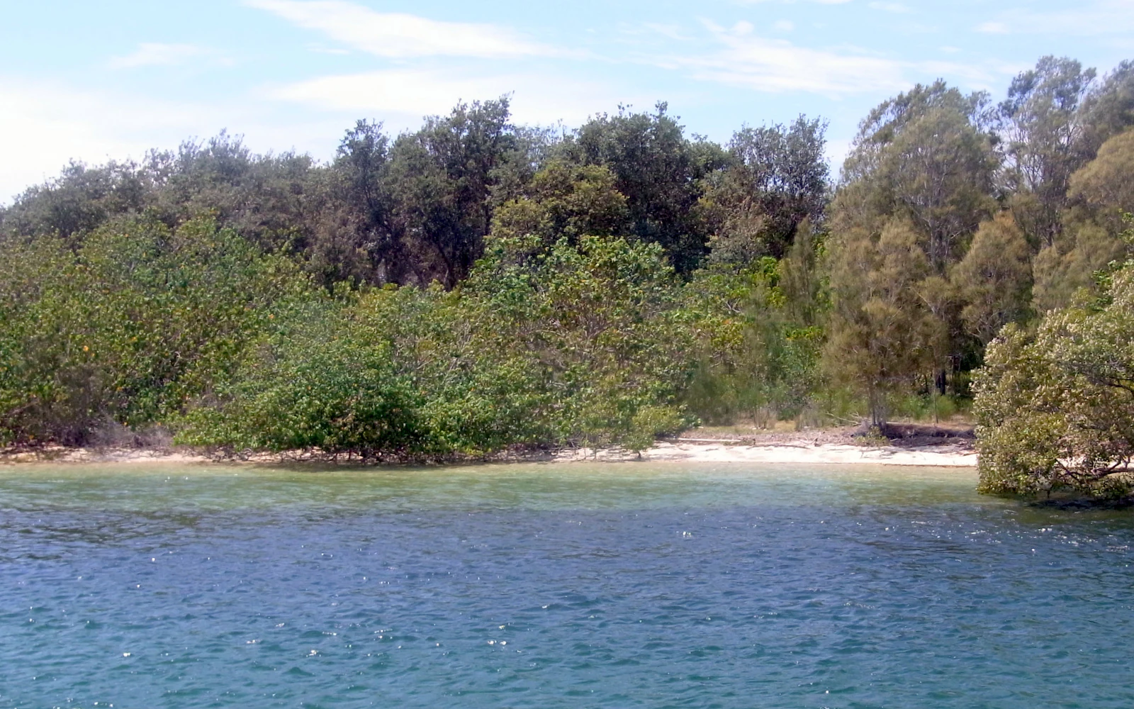
A view of the shoreline of Ukerebagh Island featuring dense mangrove trees meeting the clear water of the Tweed River.
The lush mangrove forest along the shoreline of Ukerebagh Island in the Tweed River.

Ukerabagh Island Nature Reserve history and protected-area timeline

The island has deep Indigenous history. The Minjungbal people were the first known inhabitants of the district, speaking a dialect of the Bundjalung language family broadly shared across northeastern New South Wales and southeastern Queensland.

In 1927 the area was formally declared an Aboriginal reserve. During the 1920s and 1930s, many Indigenous families were relocated to Ukerebagh under policies aimed at segregating Aboriginal people from the general population. Residents of the reserve depended on government rations but supplemented their diet with locally harvested fish, oysters, mud crabs, pippies, wallabies, lizards, and birds, reflecting the rich natural resources of the river island environment.

In 1951 the island was gazetted as 'reserved from sale for future public requirements', and the settlement was eventually abandoned in the 1960s. In 1983 the area was formally protected as Ukerabagh Island Nature Reserve under the management of the NSW National Parks and Wildlife Service, securing its future as a strict nature reserve focused on conservation of estuarine habitat and cultural values.

Ukerabagh Island Nature Reserve landscape and geographic character

The landscape of Ukerebagh Island is defined by its position within the tidal mouth of the Tweed River. The island is low-lying, reaching only about 20 meters at its highest point, and is shaped by daily tidal flows that influence both the shoreline and the vegetation communities that fringe it.

Mangroves dominate the island's edges, creating a soft, sinuous boundary between land and water. Behind the mangroves, the interior supports coastal shrub species and a small patch of littoral rainforest, a vegetation type that typically grows on low coastal land behind sand dunes or estuarine shores and is among the most reduced forest types in New South Wales.

The broader setting of the reserve is the lower Tweed estuary, a transition zone where river, coast, and subtropical hinterland meet. The position near the New South Wales–Queensland border gives the island a transitional character, sitting at the edge of two states' coastal environments.

Ukerabagh Island Nature Reserve ecosystems, habitats, and plant life

Ecologically, Ukerebagh Island Nature Reserve represents a small but representative example of the subtropical estuarine ecosystems of northeastern New South Wales. Its mangrove forests are central to its ecological identity, providing habitat structure, shelter, and feeding grounds for fish, crabs, molluscs, and shorebirds.

Four mangrove species occur in the far northeast of New South Wales, and the reserve helps protect the habitats they form. The presence of species such as David's Heart and the Coast Hibiscus contributes additional layers of coastal shrub vegetation, while the small littoral rainforest patch adds a rare dimension of closed-forest habitat in an otherwise estuarine environment.

Together these communities create a layered ecological mosaic in which mangrove margins transition into coastal scrub and patches of rainforest, all shaped by tidal, freshwater, and coastal influences.

Ukerabagh Island Nature Reserve wildlife and species highlights

Ukerebagh Island is recognized as an important site for coastal birds, supporting populations that depend on estuarine and mangrove habitats for feeding, roosting, and shelter. The combination of mangrove forests, tidal mudflats, and sheltered shoreline makes the reserve attractive to species typical of the southern Queensland and northern New South Wales coast.

The historical accounts of life on the island also highlight the broader fauna of the area, including fish, oysters, mud crabs, pippies, wallabies, lizards, and a range of bird species that were traditionally harvested or observed by Aboriginal residents. This reflects the diversity of wildlife the island has long supported, even if the formal reserve focuses primarily on habitat protection rather than species management.

Ukerabagh Island Nature Reserve conservation status and protection priorities

As a strict nature reserve under IUCN Category Ia, Ukerabagh Island is managed primarily for ecosystem protection and the preservation of natural processes, with limited public access or recreational use. The reserve contributes to the broader conservation of mangrove and littoral rainforest habitats in northeastern New South Wales, both of which are under pressure from coastal development and land-use change.

By protecting a tidal river island near the mouth of the Tweed River, the reserve helps maintain habitat continuity in an estuary that is otherwise surrounded by urban and agricultural land, particularly near Tweed Heads. Its protected status ensures that mangrove communities, patches of littoral rainforest, and associated bird populations remain shielded from the more intense pressures affecting nearby estuarine environments.

Ukerabagh Island Nature Reserve cultural meaning and human context

The reserve carries significant cultural意义 for Aboriginal communities. The Minjungbal people, who spoke a dialect of the Bundjalung language, were the traditional custodians of the district surrounding the Tweed River, including the island itself.

During the twentieth century the island became a focal point of government policies of segregation. Declared an Aboriginal reserve in 1927 and reserved from sale in 1951, it housed Indigenous families through the 1920s and 1930s. The settlement was eventually abandoned in the 1960s, but the island remains a place of ongoing cultural connection, with Aboriginal people continuing to visit the site regularly.

The reserve is also associated with Senator Neville Bonner, Australia's first Indigenous member of the federal parliament, who was born under a palm tree on the island in 1922. His birth on Ukerebagh gives the reserve a particularly notable place in the broader story of Aboriginal political representation in Australia.

Top sights and standout views in Ukerabagh Island Nature Reserve

Ukerabagh Island Nature Reserve stands out for combining mangrove-dominated estuarine habitat, a small surviving patch of littoral rainforest, and important cultural heritage on a single tidal river island.

Its protected status as a strict nature reserve ensures ongoing protection for coastal bird habitat and ecologically sensitive shoreline vegetation in a heavily modified region. The site's connection to the Minjungbal people and to Senator Neville Bonner adds a distinctive human and political history layer rarely associated with small estuarine reserves.

Best time to visit Ukerabagh Island Nature Reserve

As a small strict nature reserve, Ukerebagh Island is not primarily oriented toward casual tourism, and detailed seasonal visitation guidance is not broadly documented. In general, the lower Tweed estuary experiences mild subtropical conditions, with warmer and more humid months through the Australian summer and milder, drier conditions through winter.

For ecological interest, periods around tidal cycles are typically the most dynamic for observing mangrove and bird activity, and cooler, drier months can offer more comfortable outdoor conditions. Visitors interested in birdlife may find the cooler months productive for observation in similar coastal habitats, though specific seasonal claims for this reserve should be made cautiously given limited documentation.

Monthly climate preview

Long term temperature ranges and monthly precipitation distributions for New South Wales

Ukerabagh Island Nature Reserve Climate Normals and Annual Weather Patterns

Representative coordinate measurements reveal sustained seasonal shifts in average temperatures and daily precipitation rates across Ukerabagh Island Nature Reserve. Detailed monthly profiles provide complete data breakdowns for analyzing multiyear climate trends at a single sample elevation.
Annual mean22 °C
18 °C25 °C
Jan25°
Feb25°
Mar25°
Apr23°
May21°
Jun19°
Jul18°
Aug19°
Sep20°
Oct21°
Nov23°
Dec24°
Warmest month
February

25.2 °C

Coolest month
July

18.5 °C

Wettest month
February

5.7 mm/day

Driest month
September

1.2 mm/day

Park location guide

Geography guide, regional context, and park location map for Ukerabagh Island Nature Reserve

Ukerabagh Island Nature Reserve park geography, regions, and map view in Australia

Understand where Ukerabagh Island Nature Reserve sits in Australia through a broader geographic reading of the surrounding landscape, nearby location context, and its mapped position within the national park landscape.

How Ukerabagh Island Nature Reserve fits into Australia

Australia is a constitutional monarchy and federal parliamentary democracy comprising six states and ten territories. With a population of nearly 28 million, it is one of the world's most urbanised countries, with most people concentrated on the eastern seaboard. The country has a high Human Development Index and is known for its cultural diversity, ancient Aboriginal heritage, and unique wildlife.

Wider geography shaping Ukerabagh Island Nature Reserve in Australia

Australia occupies the entire Australian continent, the island of Tasmania, and numerous smaller islands. It is the world's flattest and driest inhabited continent, featuring vast deserts in the interior (the Outback), tropical rainforests along the eastern coast, and a coastline bordering the Indian and Pacific Oceans.

Map view of Ukerabagh Island Nature Reserve

Use this park location map to pinpoint Ukerabagh Island Nature Reserve in Australia, understand its exact geographic position, and read its mapped placement within the surrounding landscape more clearly.

Pigeon | © OpenStreetMap contributors

Location context for Ukerabagh Island Nature Reserve

New South Wales

Visual reference guide to estuarine habitats and tidal river terrain

Ukerabagh Island Nature Reserve Photos and Landscape Scenery

Visual documentation of Ukerabagh Island Nature Reserve reveals the intricate mangrove fringes and tidal estuarine terrain defining the lower Tweed River. Examining these protected landscapes provides clear insight into coastal bird habitats and rare littoral rainforest patches within New South Wales.

A view of the shoreline of Ukerebagh Island featuring dense mangrove trees meeting the clear water of the Tweed River.

Park atlas

Compare nearby regional reserves, estuarine habitats, and connected coastal landscapes

Parks Near Ukerabagh Island Nature Reserve and Surrounding Coastal Protected Areas

Browsing other protected areas near Ukerabagh Island Nature Reserve reveals broader ecological patterns across the lower Tweed estuary and subtropical coastline. Comparing adjacent reserves helps trace similar tidal ecosystems, mangrove environments, and coastal bird habitats throughout the region.
A soft watercolor painting of a landscape featuring rolling green hills, a faint mountain range in the distance, and sparse vegetation in the foreground.
Nature reserveNew South Wales
About 3 km away#1 closest

East

Cook Island Nature Reserve: Coastal Protected Landscapes and Island Geography in New South Wales

Strictly protected island terrain and offshore seabird refuge.

Cook Island Nature Reserve represents a specialized five-hectare island protected area off the northern New South Wales coastline. This offshore site functions as a vital nature reserve, characterized by its preserved scrub vegetation and role as a high-value habitat for breeding seabirds. Its geographic isolation and strict conservation focus offer a defined landscape contrast to the adjacent mainland coastal environments.

Area
0.05 km²
Established
1959
IUCN
Ia
Relief
Lowland
A soft watercolor painting depicting a coastal landscape with a green island in the middle ground and a pale sky above.
Marine protected areaNew South Wales
About 3 km away#2 closest

East

Cook Island Aquatic Reserve: Marine Protected Area and Coastal Geography Overview

Mapped marine landscapes on the New South Wales coast.

Cook Island Aquatic Reserve features a compact but ecologically rich seascape surrounding a rocky island near Fingal Head. This marine protected area demonstrates a precise zoned management strategy, preserving critical shark habitats and varied reef communities at the intersection of tropical and temperate maritime zones.

Area
0.74 km²
Established
1998
Relief
Lowland
Climate
Subtropical
Nature reserveNew South Wales
About 10 km away#3 closest

Southwest

Stotts Island Nature Reserve: Mapping Protected Rainforest Landscapes in Northern New South Wales

A fluvial river island refuge within the Tweed River valley.

Stotts Island Nature Reserve stands as a significant protected area in New South Wales, preserving a rare, intact block of lowland subtropical rainforest. As a dynamic river island shaped by alluvial deposits and flood cycles, the reserve functions as critical habitat for local species while maintaining a distinct forest canopy against the backdrop of the heavily developed Tweed Valley floodplain.

Area
1.41 km²
Established
1971
IUCN
Ia
Relief
Lowland
National parkQueensland
About 12 km away#4 closest

West

Nicoll Scrub National Park: Queensland National Park Geography and Landscape

Explore the mapped boundaries and regional context of this protected area.

Nicoll Scrub National Park is a designated national park contributing to the rich protected landscape tapestry of Queensland, Australia. This entry provides detailed information focused on its geographic identity, allowing for atlas-style exploration of its mapped boundaries and its role within the state's natural geography. Understand the specific context of this park as a protected natural area.

Area
0.27 km²
Established
1986
IUCN
II
Relief
Mountain
National parkQueensland
About 14 km away#5 closest

Northwest

Burleigh Head National Park: Queensland National Park Geographic Atlas

Explore mapped boundaries and regional landscape context.

Delve into the specifics of Burleigh Head National Park, a protected national park located in Queensland, Australia. This detail page offers a focused view on its geographic setting and landscape characteristics, enabling atlas-based discovery. Understand the park's protected area status and its role within the regional geography of northeastern Australia, providing clear context for map-oriented exploration.

Area
0.3 km²
Established
1994
IUCN
II
Visitors
1.2M annual
National parkQueensland
About 19 km away#6 closest

West

Springbrook National Park National Park: Exploring Queensland's Protected Landscape Atlas

Mapped boundaries and regional geographic context for this Australian national park.

Springbrook National Park serves as a vital entry for understanding protected landscapes within Queensland, Australia. As a national park, it offers a distinct geographic profile, contributing to the broader atlas of conservation areas in northeastern Australia. Users can explore its specific mapped boundaries and appreciate its role in the regional geography, providing a factual basis for understanding the distribution and character of Australia's natural parklands.

Area
61.56 km²
Established
1990
IUCN
II
Relief
Mountain
National parkNew South Wales
About 21 km away#7 closest

South

Mooball National Park: Protected Landscape Identity and Geographic Context in New South Wales

Atlas exploration of its mapped boundaries and regional setting.

Mooball National Park is a key protected area within New South Wales, Australia, offering a distinct focus for atlas and geography exploration. This detail page illuminates its identity as a national park, detailing its mapped geographic presence and the surrounding regional context. Understand the protected landscape's characteristics and its unique position within the broader atlas of Australian natural reserves.

Area
12 km²
Established
1999
IUCN
II
Relief
Lowland
Nature reserveNew South Wales
About 28 km away#8 closest

West

Couchy Creek Nature Reserve: Mapped Protected Landscapes in New South Wales

Subtropical forest remnants and vegetation corridors

Couchy Creek Nature Reserve protects a 217 hectare mosaic of lowland rainforest and wet sclerophyll forest. Situated in the Northern Rivers of New South Wales, the reserve forms an essential refuge for threatened plant species and maintains critical ecological connectivity across a heavily modified agricultural region.

Area
2.17 km²
Established
1999
IUCN
Ia
Relief
Upland

Common questions about visiting, size, designation, and location context for Ukerabagh Island Nature Reserve

Ukerabagh Island Nature Reserve FAQs for park facts, access, geography, and protected area context

Find quick answers about Ukerabagh Island Nature Reserve, including protected-area facts, park geography, trail and visitor context, and how the park fits into its surrounding country and regional landscape.
MoriAtlas Explorer

Continue Your Protected Areas Search Across the Global Atlas

Deepen your exploration by continuing the structured search for national parks and protected areas worldwide. Utilize the comprehensive filtering capabilities to compare different conservation landscapes and refine your understanding of global park geography. Discover more about the distribution and characteristics of protected natural areas.

Global natural geography