Mori Atlas logo
Nature reserveUlandra Nature Reserve

A rugged conservation refuge rising from the Southern Tablelands to the peak of Mount Ulandra

Ulandra Nature Reserve: Protected Landscape Geography and Mapped Forest Boundaries in New South Wales

Ulandra Nature Reserve encompasses approximately 3,930 hectares of hilly terrain, forming a critical ecological bridge between the Southern Tablelands and the Riverina fringe in New South Wales. This protected area preserves intact stands of black cypress pine and eucalypt forest that remain largely undisturbed compared to the surrounding agricultural plains. The reserve features the distinct topography of the Ulandra Range, providing essential habitat for threatened bird species within its catchment basin.

strict nature reserveSouthern Tablelandscypress pine forestopen woodlandmountain landscaperiverina fringe

Ulandra Nature Reserve

Nature reserve

Park overview

Structured park overview, official facts, and landscape profile for Ulandra Nature Reserve

Ulandra Nature Reserve park facts, protected area profile, and essential visitor context

Review the core facts for Ulandra Nature Reserve, including designation, size, terrain, visitor scale, habitats, and operating context in one park-focused overview.

About Ulandra Nature Reserve

Ulandra Nature Reserve occupies a block of hilly country where the Southern Tablelands meet the eastern fringe of the Riverina in New South Wales. The reserve sits within a heavily agricultural landscape, and its value is driven largely by the fact that the surrounding land has been extensively cleared for cropping and grazing. Within that context, Ulandra functions as a refuge for plant communities and animal species that have largely disappeared from nearby districts.

The defining geographic feature of the reserve is the Ulandra Range and its highest point, Mount Ulandra. The surrounding plain lies at about 200 to 300 metres elevation, and the land rises abruptly at Mount Ulandra to a summit near 761 metres. Much of the reserve lies above the 500-metre contour, and the terrain includes rough rocky ridges, steep-sided gullies, and a relatively intact catchment that drains into Merrybundinah Creek. The combination of elevation, aspect, and slope produces a mosaic of woodland habitats that vary across the hills.

Vegetation is dominated by open forest of Callitris endlicheri, the black cypress pine, interspersed with a variety of eucalypts. Wattles are widespread, including the Cootamundra wattle that gave the nearby town its common name. The reserve was explicitly established to protect and conserve stands of this species in the portion of its natural range where it remains ecologically appropriate. As a strict nature reserve under IUCN Category Ia, the area is managed primarily for biodiversity conservation rather than recreation, and public access is by permission only through the NSW National Parks and Wildlife Service.

The reserve is also significant for its wildlife. It supports populations of grey kangaroos and swamp wallabies, both brushtail and ringtail possums, and an undetermined assemblage of bats. The woodland bird community is exceptionally rich, with more than 110 species recorded on the Atlas of NSW Wildlife database, and a notable concentration of species that are vulnerable within New South Wales, including the superb parrot and the turquoise parrot, as well as small woodland-dependent passerines such as robins, treecreepers, and finches.

Ulandra also retains evidence of long Aboriginal presence in the landscape through stone artifacts and other recorded relics, alongside more recent historic features tied to European pastoral use, including fence lines, stockyards, buildings, and dams. Despite that history of grazing and selective clearing, the reserve's relative intactness sets it apart from most other bushland fragments in the region.

Quick facts and research context for Ulandra Nature Reserve

Ulandra Nature Reserve is a strict nature reserve in New South Wales, Australia, classified under IUCN Category Ia. It encompasses about 39 square kilometres of the Ulandra Range, with Mount Ulandra rising to about 761 metres above sea level above a surrounding plain that lies between roughly 200 and 300 metres.

The reserve was dedicated in 1981 and progressively expanded until 1983. It is managed by the NSW National Parks and Wildlife Service and is listed on the Register of the National Estate. Access is restricted because of its strict nature reserve status, and entry requires permission from the managing authority.

Protection and recognition

Documented terrestrial protection scope, designation history, and management status.

Ulandra Nature Reserve Protection Status and International Recognition Data

Ulandra Nature Reserve maintains a documented terrestrial protection scope without imported international recognition sources or transboundary designation records. Reviewing these verified administrative facts clarifies the baseline conservation status and official management parameters assigned to the protected area.

Protection details

Protection scope
Terrestrial
Transboundary protection
No
Park context

Deeper park guide and search-rich context for Ulandra Nature Reserve

Ulandra Nature Reserve history, landscape, wildlife, and travel context

Explore Ulandra Nature Reserve through its history, landscape character, ecosystems, wildlife, conservation priorities, cultural context, and seasonal travel timing in a structured park guide built for atlas discovery and search intent.

Why Ulandra Nature Reserve stands out

Ulandra Nature Reserve is best known for protecting one of the largest remaining stands of Cootamundra wattle within its natural, restricted distribution, and for safeguarding an unusually intact example of cypress pine and eucalypt open forest in an otherwise heavily cleared agricultural district. It is also strongly associated with the conservation of the superb parrot, which uses the reserve for foraging and breeding, and with a suite of other woodland-dependent bird species that have become rare across the surrounding region. The presence of Mount Ulandra and its rugged ridges gives the reserve a distinctive topographic profile within the gently undulating countryside that surrounds it.
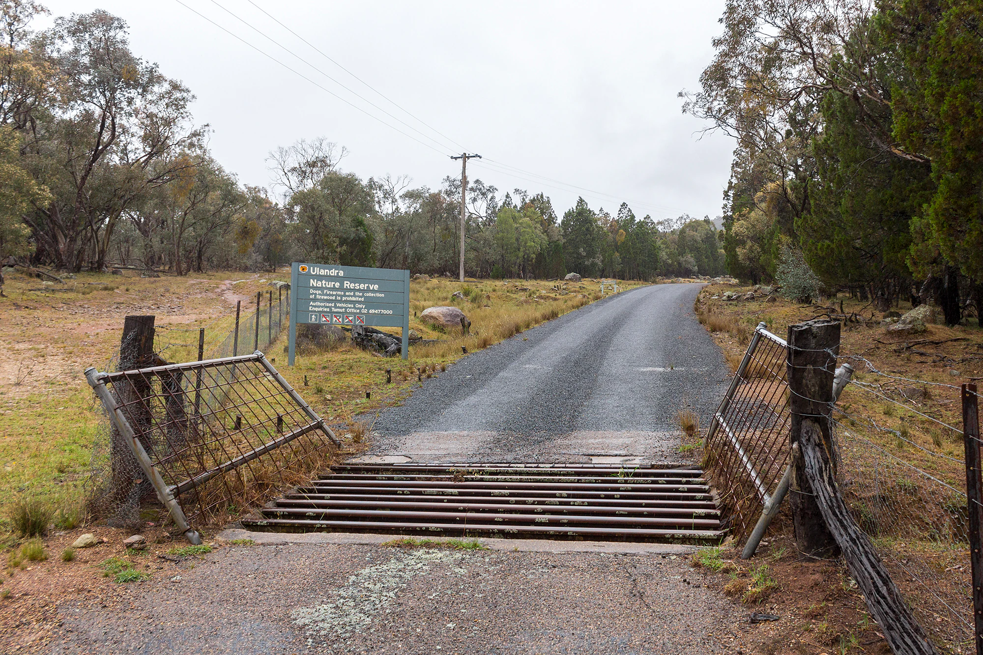
A gravel road leads into Ulandra Nature Reserve, passing through an open metal cattle grid with a green park information sign visible on the left.
The entrance to Ulandra Nature Reserve via Tower Road, featuring a cattle grid and park signage.

Ulandra Nature Reserve history and protected-area timeline

Ulandra Nature Reserve was formally dedicated in June 1981 under the management of the NSW National Parks and Wildlife Service. The reserve was created primarily to protect natural stands of the Cootamundra wattle, Acacia baileyana, within the species' limited native range, at a time when clearance for agriculture and the spread of ornamental plantings were placing pressure on the original populations.

After the initial dedication in 1981, additional land was progressively added to the reserve until 1983, expanding its footprint and strengthening its role as a refuge for native vegetation. The reserve is listed on the Register of the National Estate, where its Statement of Significance highlights both its botanical importance and its value as habitat for threatened bird species.

Before European settlement, the area was used by Aboriginal people, and the reserve still contains recorded stone artifacts and other cultural relics. Following European settlement, the landscape was shaped by pastoral activity including clearing, grazing, and minor timbergetting, traces of which remain visible today in old fence lines, stockyards, buildings, and stock water dams. The reserve was established in part as a response to that agricultural transformation, with the aim of preserving a representative example of the original open forest in a district where most of the native bush had been lost.

Ulandra Nature Reserve landscape and geographic character

The landscape of Ulandra Nature Reserve is built around the Ulandra Range, a compact block of wooded hills that rises sharply out of the surrounding countryside. Immediately west of the reserve lies a gently undulating agricultural plain that lies between approximately 200 and 300 metres above sea level. Where the plain meets the range, the elevation rises abruptly, climbing through rough rocky ridges and steep-sided gullies to the summit of Mount Ulandra at about 761 metres above sea level.

Much of the reserve sits above 500 metres elevation, giving the hills a distinctly cooler and more rugged character than the plains below. The range preserves a small catchment that drains into Merrybundinah Creek; this catchment is one of the more intact drainage systems in the district and stands out within a landscape otherwise heavily modified by farming. Within the reserve, the topography produces a variety of slopes and aspects that influence vegetation cover and create the structural complexity typical of dry sclerophyll forest in this part of New South Wales.

Ulandra Nature Reserve ecosystems, habitats, and plant life

The vegetation of Ulandra Nature Reserve is dominated by open forest, with black cypress pine, Callitris endlicheri, forming much of the canopy alongside a variety of eucalypts. This vegetation type corresponds to regional communities that have been extensively cleared elsewhere on the south-western slopes, and Ulandra is regarded as a highly important surviving remnant of that woodland system. Wattles are a prominent feature of the understorey and mid-storey, including the Cootamundra wattle that the reserve was established to protect.

Beyond its canopy composition, the reserve is ecologically valuable because of the way it preserves habitat in a landscape dominated by agriculture. The combination of rocky ridges, gullies, sheltered slopes, and the relatively undisturbed Merrybundindah Creek catchment creates a mosaic of microhabitats within a compact area. These support a mix of breeding, foraging, and dispersal habitat for woodland birds, arboreal mammals, and a bat assemblage that remains incompletely surveyed. Ecologically, the reserve functions less as a remote wilderness than as a critically positioned refuge within a heavily modified regional landscape.

Ulandra Nature Reserve wildlife and species highlights

Ulandra Nature Reserve supports a mammal community that includes eastern grey kangaroos, swamp wallabies, common brushtail possums, and common ringtail possums, along with an undetermined number of bat species that roost in the range's gullies and old trees.

The reserve is most significant, however, for its birdlife. Records held by the Atlas of NSW Wildlife show more than 110 bird species for the area. Several species listed as vulnerable in New South Wales have been recorded, including the little eagle, gang-gang cockatoo, turquoise parrot, brown treecreeper, speckled warbler, varied sittella, hooded robin, scarlet robin, flame robin, and diamond firetail.

Above the rest, the superb parrot stands out as the reserve's most ecologically important species. The woodland provides critical foraging and breeding habitat for this parrot in a region where much of its former habitat has been cleared, and Ulandra is repeatedly referenced in management descriptions as a key site for the species' long-term persistence in this part of the Southern Tablelands.

Ulandra Nature Reserve conservation status and protection priorities

Ulandra Nature Reserve is a strict nature reserve classified under IUCN Category Ia, meaning it is managed primarily for ecosystem protection and scientific values rather than for public recreation. Its conservation significance lies in preserving open forest dominated by Callitris endlicheri and associated eucalypts within the south-western slopes, a vegetation type that has been substantially reduced in extent across the surrounding agricultural district.

The reserve is also valued for safeguarding part of the natural distribution of the Cootamundra wattle and, importantly, for providing habitat for the threatened superb parrot and a suite of other vulnerable woodland bird species. The Register of the National Estate lists the reserve as a regionally significant habitat isolate for many species that are now uncommon locally due to historical clearing.

Conservation challenges include ongoing pressure from introduced animals, especially feral pigs, predation and competition from other non-native species, and infestations of invasive weeds. Damage from past pastoral clearing and the construction of stock water dams continues to shape the ecological condition of parts of the reserve, and a telecommunications inholding within its boundary creates a localized management issue. Despite these pressures, Ulandra remains a high-priority refuge for woodland biodiversity in an otherwise heavily cleared agricultural landscape.

Ulandra Nature Reserve cultural meaning and human context

Ulandra Nature Reserve contains evidence of long Aboriginal use of the landscape. Stone artifacts and other cultural relics have been recorded within the reserve, indicating that the wooded hills and surrounding plains were integrated into the lives of Aboriginal people prior to European settlement.

Following European settlement, the area was shaped by pastoral use, including clearing, grazing, and small-scale timbergetting. The presence of old fence lines, stockyards, buildings, and dams within parts of the reserve reflects this agricultural history, and these features remain part of the contemporary cultural landscape. The establishment of the reserve in 1981 represents a shift away from that pastoral legacy toward long-term biodiversity protection of a representative fragment of the original woodland.

Top sights and standout views in Ulandra Nature Reserve

Ulandra Nature Reserve's strongest points of distinction are its unusually intact stand of Callitris endlicheri and eucalypt open forest, its role as a key refuge for the superb parrot, and its importance as one of the few remaining sites where the Cootamundra wattle occurs naturally rather than as an ornamental escape. The abrupt rise of Mount Ulandra above the surrounding agricultural plain gives the reserve a striking physical presence, and the relatively undisturbed catchment of Merrybundinah Creek adds a hydrological dimension that is rare in this part of New South Wales.

Best time to visit Ulandra Nature Reserve

As a strict nature reserve, Ulandra is not a destination for casual recreation, and visits are possible only with permission from the NSW National Parks and Wildlife Service. For those with research or management reasons to visit, the cooler months of late autumn, winter, and early spring tend to offer more comfortable conditions for fieldwork in the rugged terrain, while spring can also bring flowering wattles and more visible bird activity. Summer heat in the open forest can be intense, particularly on the exposed ridges, so planning around milder seasons is generally advisable.

Monthly climate preview

Long-term temperature and precipitation records across twelve months of observation

Ulandra Nature Reserve Climate Normals and Monthly Weather Patterns

Historical climate data for Ulandra Nature Reserve maps out measured shifts in average monthly temperature and daily precipitation at a representative elevation point. Accessing the complete monthly profile provides deeper historical context regarding long-term meteorological rhythms across the terrain.
Annual mean15 °C
6 °C24 °C
Jan24°
Feb23°
Mar20°
Apr15°
May11°
Jun
Jul
Aug
Sep11°
Oct15°
Nov18°
Dec21°
Warmest month
January

24.2 °C

Coolest month
July

6.5 °C

Wettest month
June

2.3 mm/day

Driest month
April

1.2 mm/day

Park location guide

Geography guide, regional context, and park location map for Ulandra Nature Reserve

Ulandra Nature Reserve park geography, regions, and map view in Australia

Understand where Ulandra Nature Reserve sits in Australia through a broader geographic reading of the surrounding landscape, nearby location context, and its mapped position within the national park landscape.

How Ulandra Nature Reserve fits into Australia

Australia is a constitutional monarchy and federal parliamentary democracy comprising six states and ten territories. With a population of nearly 28 million, it is one of the world's most urbanised countries, with most people concentrated on the eastern seaboard. The country has a high Human Development Index and is known for its cultural diversity, ancient Aboriginal heritage, and unique wildlife.

Wider geography shaping Ulandra Nature Reserve in Australia

Australia occupies the entire Australian continent, the island of Tasmania, and numerous smaller islands. It is the world's flattest and driest inhabited continent, featuring vast deserts in the interior (the Outback), tropical rainforests along the eastern coast, and a coastline bordering the Indian and Pacific Oceans.

Map view of Ulandra Nature Reserve

Use this park location map to pinpoint Ulandra Nature Reserve in Australia, understand its exact geographic position, and read its mapped placement within the surrounding landscape more clearly.

Pigeon | © OpenStreetMap contributors

Location context for Ulandra Nature Reserve

New South Wales

Visual reference guide to the protected range, terrain, and native woodland habitats

Ulandra Nature Reserve Photos and Landscape Scenery

Visual records capture the rugged topography of the Ulandra Range and its abrupt elevation rise above the agricultural plains. Examining these protected habitats clarifies the structural complexity of the native cypress pine forests and local wildlife refuges.

A gravel road leads into Ulandra Nature Reserve, passing through an open metal cattle grid with a green park information sign visible on the left.

Park atlas

Compare nearby regional reserves, woodland habitats, and mountain terrain

Other Parks Near Ulandra Nature Reserve and Surrounding Protected Areas

Browse other parks near Ulandra Nature Reserve to compare regional protected areas, forest remnants, and local conservation landscapes. Expanding the search across nearby national parks and reserves reveals broader ecological patterns in the surrounding district.
Watercolor depiction of a river, trees, and rolling hills in a landscape
National parkNew South Wales
About 35 km away#1 closest

North

Jindalee National Park: New South Wales National Park Protecting Cypress Pine Woodlands

Explore unique mapped terrain and regional conservation landscape.

Jindalee National Park represents a vital conservation effort in New South Wales, safeguarding remaining cypress pine woodlands and Critically Endangered grassy woodland ecosystems. Situated in the South West Slopes region, its undulating terrain and drainage lines form a distinctive natural landscape. The park's designation as a national park underscores its importance for preserving threatened species habitats and offers a focused point for atlas-driven discovery of its unique protected-area character and geographic context.

Area
10.76 km²
Established
2011
IUCN
II
Relief
Lowland
Nature reserveNew South Wales
About 57 km away#2 closest

Northwest

Ingalba, Big Bush and Pucawan Nature Reserves: Regional Geography and Protected Woodland Map

Inland New South Wales conservation complex within the Lachlan Fold Belt

These three nature reserves function as one of the most substantial surviving remnants of mugga ironbark and western grey box woodland in southern inland New South Wales. Located west of Temora, the reserves protect forty-nine square kilometres of distinct woodland and dry heathland communities that provide essential habitat corridors across a heavily cleared agricultural region. The mapping highlights the unique topography and geological variety that sustains this protected landscape.

Area
49.27 km²
IUCN
Ia
Relief
Upland
Climate
Temperate
Nature reserveNew South Wales
About 61 km away#3 closest

South

Tarcutta Hills Reserve: Protected Nature Reserve and Woodland Geography in New South Wales

Essential conservation landscape on the western slopes of the Great Dividing Range

Located in New South Wales, Tarcutta Hills Reserve is a critical nature reserve managing intact grassy white box woodland. The property features rolling hills and drainage lines, serving as a vital corridor for woodland-dependent species. This protected area stands as a representative example of pre-clearing landscapes that once characterized the region, now maintained by Bush Heritage Australia for its high conservation value.

Area
7.38 km²
Established
1999
Relief
Upland
Scope
Terrestrial
Nature reserveNew South Wales
About 63 km away#4 closest

East

Burrinjuck Nature Reserve: Protected Inland Forest Geography and Conservation Mapping

Diverse eucalypt forest mosaic in the south west slopes of New South Wales

Located within the south west slopes of New South Wales, Burrinjuck Nature Reserve is a significant protected landscape known for its remarkably high diversity of forest types in a compact area. From moist grass forests to heathy woodlands, the reserve provides critical habitat for threatened plant populations and an unusually rich variety of woodland birds. Its terrain offers a glimpse into the ecological complexity of inland Australian catchments and ridge systems.

Area
52.5 km²
Established
1984
IUCN
Ia
Relief
Upland
Nature reserveNew South Wales
About 66 km away#5 closest

Northwest

Boginderra Hills Nature Reserve: Protected Granite Landscapes in New South Wales

An ecological map of the Riverina woodland refuge.

Boginderra Hills Nature Reserve protects a distinct granite ridge that remains largely intact amidst the heavily modified plains of the Riverina. This site functions as a strictly managed conservation area, preserving a mosaic of native eucalypt and cypress pine communities that provide essential habitat for regional woodland bird species and other native fauna.

Area
7.56 km²
Established
1982
IUCN
Ia
Relief
Upland
Nature reserveNew South Wales
About 66 km away#6 closest

Southeast

Black Andrew Nature Reserve: Protected Landscape and Geographic Mapping in New South Wales

Strict conservation habitat within the Murrumbidgee River catchment

Black Andrew Nature Reserve features an intricate landscape of undulating slopes and riparian gullies on the south west slopes of New South Wales. The reserve is notable for its high botanical richness, with seven distinct vegetation communities mapped across substrates that range from granite to basalt. This protected area provides essential habitat for multiple threatened species while maintaining vital forest connectivity along the Burrinjuck Dam shoreline.

Area
15.59 km²
Established
2001
IUCN
Ia
Relief
Upland
Watercolor painting showing mountains, fields, and a river
National parkNew South Wales
About 71 km away#7 closest

South

Kosciuszko National Park: Australia's Highest Alpine Terrain and Mapped Protected Landscape

Discover unique glacial landscapes and geographic context in New South Wales.

Kosciuszko National Park represents the pinnacle of Australia's alpine geography, preserving the continent's only true alpine ecosystems. This extensive national park in New South Wales features dramatic glacial landforms, including its namesake Mount Kosciuszko, Australia's highest peak. Users can explore the park's mapped boundaries, surrounding natural terrain, and unique landscape features for a comprehensive understanding of this significant protected area.

Area
6,900 km²
Established
1944
IUCN
II
Visitors
3.3M annual
Nature reserveNew South Wales
About 72 km away#8 closest

Southeast

Wee Jasper Nature Reserve: Protected Woodland Geography and Ecological Mapping in New South Wales

Explore the forest terrain and conservation landscape of this Southern Tablelands reserve.

Wee Jasper Nature Reserve provides a focused look at how slope aspect and drainage shape forest plant communities. Located near the Goodradigbee River corridor in New South Wales, this reserve protects a high concentration of rare flora within a compact, strictly managed geographic boundary.

Area
6.3 km²
Established
1979
IUCN
Ia
Relief
Upland

Common questions about visiting, size, designation, and location context for Ulandra Nature Reserve

Ulandra Nature Reserve FAQs for park facts, access, geography, and protected area context

Find quick answers about Ulandra Nature Reserve, including protected-area facts, park geography, trail and visitor context, and how the park fits into its surrounding country and regional landscape.
MoriAtlas Explorer

Continue Your Protected Areas Search Across the Global Atlas

Deepen your exploration by continuing the structured search for national parks and protected areas worldwide. Utilize the comprehensive filtering capabilities to compare different conservation landscapes and refine your understanding of global park geography. Discover more about the distribution and characteristics of protected natural areas.

Global natural geography