
Mori Atlas logo
Protected areaUlmener Maar

A study in geological youth, medieval history, and meromictic volcanic waterbodies

Ulmener Maar: Protected Crater Lake Landscape and Volcanic Terrain in the Eifel Highlands

The Ulmener Maar represents a significant geological feature within the Eifel highlands of Rheinland-Pfalz. As the youngest maar in the Volcanic Eifel, this crater lake illustrates complex stratification and sits enclosed by a forested tuff ring. Visitors can study the transition between ancient Devonian basement rock and younger volcanic ejecta, while the site offers a unique spatial link between its crater waters and the historical ruins of 11th-century knightly castles.

volcanic maarEifelcrater lakemeromictic laketuff ringcastle ruins
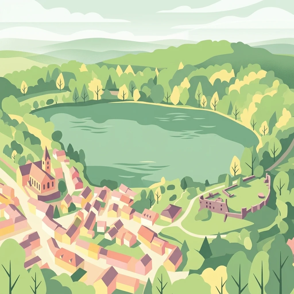
A flat-style illustration depicting the circular Ulmener Maar crater lake nestled among trees, with a town containing a prominent church and castle ruins situated on its banks.

Ulmener Maar

Protected area

Park overview

Structured park overview, official facts, and landscape profile for Ulmener Maar

Ulmener Maar park facts, protected area profile, and essential visitor context

Review the core facts for Ulmener Maar, including designation, size, terrain, visitor scale, habitats, and operating context in one park-focused overview.

About Ulmener Maar

The Ulmener Maar sits on the eastern edge of the town of Ulmen, deep in the Eifel uplands of Rhineland-Palatinate. Although small, at roughly 510 meters long and 250 meters wide, it is one of the defining landscape features of the western Eifel. A circular walking trail runs around the largely forested shoreline, allowing visitors to experience the transition from the lake through the steep crater walls up to the rim of the tuff ring.

Geologically, the maar is a textbook example of the Eifel's explosive volcanic history. The original eruption blasted a crater roughly 86 meters deep into the underlying Lower Devonian bedrock, which is still visible in exposed sections above the waterline. Around the crater, a ring of tuff built up from volcanic ash, lapilli, and shattered country rock, rising on average about 20 meters above the surrounding land. Because the maar formed after the much larger eruption of the Laacher See volcano, it is considered the youngest confirmed maar in the Eifel volcanic field, with a current best-estimate age of around 11,000 years, although radiocarbon dates taken from the tuff layers range from roughly 7,300 to nearly 11,000 years, and geologists accept an approximate age band of 9,500 to 12,400 years.

What makes Ulmener Maar stand out within the broader Eifel volcanic landscape is how geology and medieval history share the same stage. On the southern section of the tuff wall rise the two Ulmen castle ruins, the larger Oberburg and the smaller Niederburg. The site has been occupied since the 11th century, and the castles were typically held jointly by a family group, a structure known as a Ganerbschaft. Today the ruins are a striking feature of the hike around the lake, and they form the visual anchor for many of the legends attached to the maar.

Just to the north of the lake lies the Jungferweiher, an older and originally dry maar crater formed by a much larger eruption roughly 118,000 years ago. In 1942 the marshy floor of this older crater was deliberately dammed to recreate a waterbody, and the resulting pond has become a noted bird reserve. A walkable former mine tunnel, the Ulmener Maar Stollen, now connects the two maars underground, turning what would otherwise be two separate geological curiosities into a single visitor landscape.

Quick facts and research context for Ulmener Maar

Ulmener Maar is a volcanic crater lake in the Eifel region of Rhineland-Palatinate, in the town area of Ulmen. It is classified as a meromictic lake, meaning its water layers do not fully mix, and it reaches a maximum depth of roughly 37 meters. The lake is encircled by a wall of tuff, built up from the pyroclastic debris of the maar's own eruption, averaging around 20 meters in height.

Park context

Deeper park guide and search-rich context for Ulmener Maar

Ulmener Maar history, landscape, wildlife, and travel context

Explore Ulmener Maar through its history, landscape character, ecosystems, wildlife, conservation priorities, cultural context, and seasonal travel timing in a structured park guide built for atlas discovery and search intent.

Why Ulmener Maar stands out

The Ulmener Maar is best known for being the youngest maar in the Volcanic Eifel, and for the unusually clear overlap of volcanic geology and medieval history that surrounds it. On its southern tuff rim stand the ruins of the 11th-century Ulmen castles, whose knights still appear in regional legend and folklore. The lake is also notable among Eifel maars for its meromictic stratification, which sets it apart ecologically from the more typical mixed maar lakes.
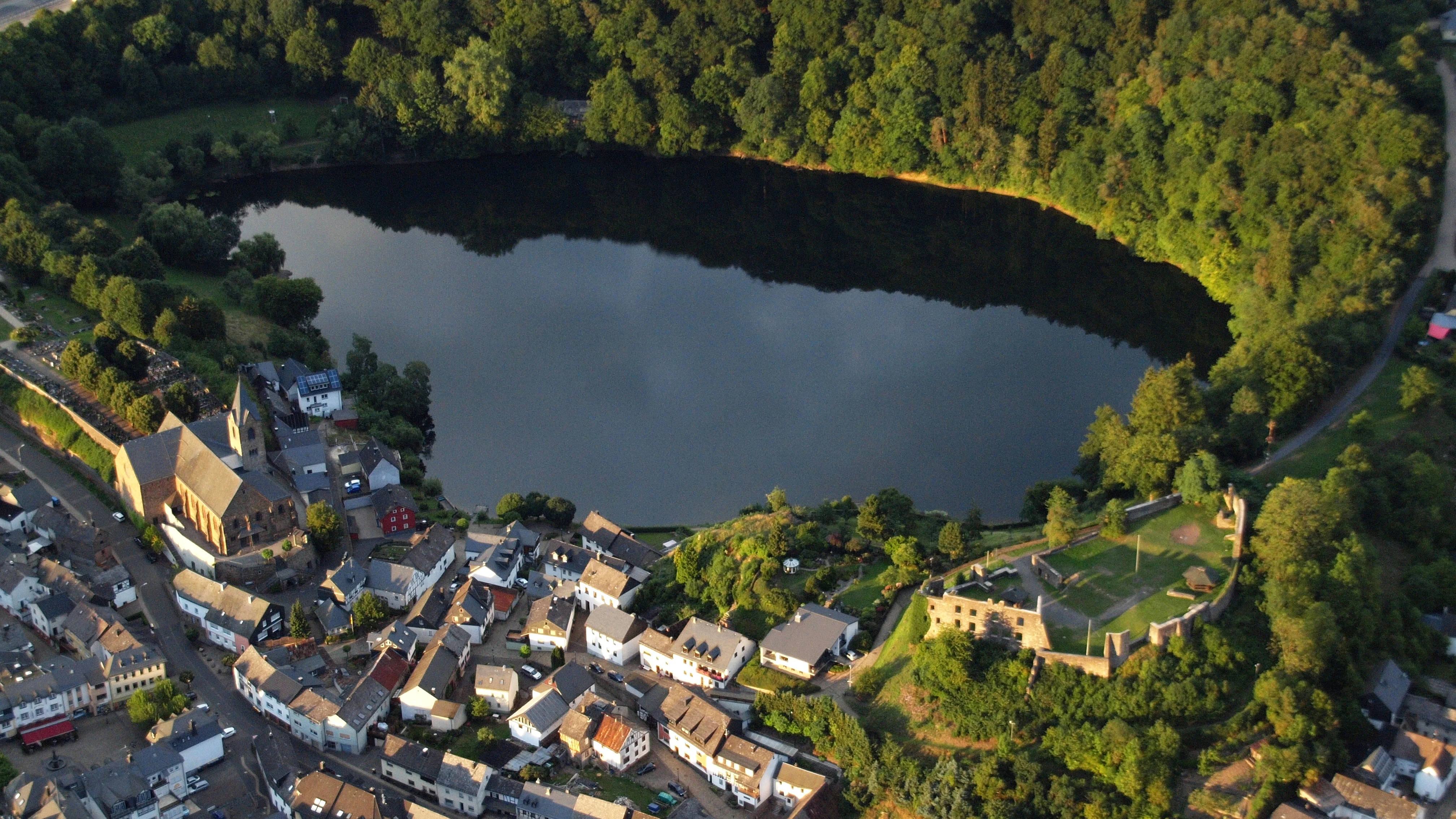
An aerial perspective of a dark, circular volcanic crater lake surrounded by dense forest, with the town of Ulmen and castle ruins visible along the shoreline.
An aerial view of the Ulmener Maar, a volcanic crater lake, situated adjacent to the town of Ulmen.

Ulmener Maar history and protected-area timeline

The geological history of the Ulmener Maar begins with a phreatomagmatic explosion that punched a deep crater into Devonian bedrock and piled the ejected material into the surrounding tuff wall. Radiocarbon dating of organic remains at the base of the tuff layers has produced a wide range of ages, between roughly 7,335 and 10,920 years. With additional geological evidence, researchers place the eruption in an approximate band of 9,500 to 12,400 years ago, making it the youngest known maar in the Eifel volcanic field, post-dating the catastrophic Laacher See eruption. Volcanologists at the Smithsonian Institution date the last eruptive activity to between about 8890 and 8590 BC.

The human history of the site begins on the tuff wall itself. The Ulmen castles, whose ruins still dominate the southern rim, were first established in the 11th century. Like several other castles in the region, they were held as a Ganerbschaft, a shared inheritance in which multiple branches of a knightly family occupied and defended the fortress together. This unusual succession arrangement is also the source of the most famous legend attached to the maar, in which the appearance of a giant pike-like fish in the lake foretold the death of one of the castle's co-heirs. The story was recorded in 1542 by the Basel scholar Sebastian Münster, who described the maars of the Eifel and their strange depth, lack of surface inflow, and rich fish life.

In the modern era, the lake's ecological character has increasingly come into focus. The Ulmener Maar is classified as a meromictic lake, meaning that its deep water does not regularly turn over into the surface layer. Because of recurring blue-green algae blooms, local authorities issued warnings against direct contact with the water, citing risks of skin irritation and allergic reactions. In the same district, the older and initially dry Jungferweiher maar was deliberately re-flooded in 1942, leading to its current ecological importance as both a fishing water and a protected bird reserve.

Ulmener Maar landscape and geographic character

The Ulmener Maar occupies a shallow, irregular basin roughly 510 meters long along its northwest to southeast axis and about 250 meters wide across that axis. Around its rim rises the tuff wall of the original eruption, averaging about 20 meters in height and largely covered with forest. A circular hiking trail traces the shoreline through this wooded setting, linking the lakeside itself to the higher ground of the crater rim.

Inside the crater wall, the exposed rock above the waterline belongs to the Lower Devonian basement into which the original eruption cut. The contrast between the older Devonian bedrock at the base and the younger tuff above it is one of the clearest landscape features of the site. Beyond the immediate maar basin, the Eifel terrain rolls outward as a plateau of mixed forest, pasture, and small villages, with Ulmen lying just to the west.

The neighboring Jungferweiher adds a second, older volcanic landform to the area. Its much larger original crater, formed around 118,000 years ago, was long dry before being dammed in the twentieth century, and the present-day pond sits within a broad, open hollow that visually balances the steeper, forested walls of the Ulmener Maar itself.

Ulmener Maar ecosystems, habitats, and plant life

Ecologically, the Ulmener Maar is defined by its volcanic origin, its unusual water chemistry, and its heavily wooded crater. The lake is meromictic, a rare condition in which the water column does not fully mix from top to bottom each year, producing stable stratification and unusual oxygen and nutrient conditions at depth. This stratification strongly shapes the lake's biology and sets it apart from the better-mixed maar lakes elsewhere in the Eifel.

The shadier parts of the crater are clothed in dense forest that climbs up both the inner slopes and the outer tuff wall, giving the lake a noticeably enclosed, sheltered atmosphere. Wet meadow and marshy ground occupy parts of the original Jungferweiher basin north of the lake, which now supports waterbirds and other wetland-dependent species. Periodic blue-green algae blooms have led local authorities to warn visitors against skin contact with the lake water, in order to prevent irritation and allergic reactions.

Because the lake is small and meromictic, it does not support the same kind of large-scale fish populations found in some other Eifel maars, although the adjacent Jungferweiher is known for its fish stocks and attracts anglers. Combined, the forested crater rim, the meromictic lake, and the wet meadows of the older maar form a coherent ecological complex that is small but unusually layered for the western Eifel.

Ulmener Maar wildlife and species highlights

The Ulmener Maar itself, due to its meromictic character, is not especially noted for abundant fish life and is currently closed to direct water contact by public health warnings during algae blooms. The real wildlife focus of the area lies at the neighboring Jungferweiher, an older maar basin that has been deliberately restored as a waterbody and now serves as a bird reserve at its northern end. Here, rare and threatened bird species can be observed in a setting that combines open water with surrounding marsh and pasture.

The forested crater walls of both maars support typical central European woodland fauna, and the mix of forest, wetland and open water around the two basins creates a varied local habitat despite the small total area. Anglers are also drawn to the fish-rich waters of the Jungferweiher, giving the area an unusual combination of birdwatching, fishing, and geological interest within easy walking distance of each other.

Ulmener Maar conservation status and protection priorities

The Ulmener Maar is listed as a nature reserve within the Cochem-Zell district of Rhineland-Palatinate, recognizing both its geological significance as one of the youngest maars in the Eifel and its ecological value as a rare meromictic lake in central Europe. The protection framework extends naturally to the surrounding tuff wall, the forested crater rim, and the adjacent Jungferweiher, which is also designated as a protected area and supports both aquatic and bird conservation values.

Conservation relevance here is driven less by species count than by rarity. Meromictic lakes are uncommon in Germany, and the Ulmener Maar's stable stratification gives it scientific interest beyond the immediate region. Blue-green algae outbreaks have required active management, including public warnings about skin contact with the water, and the deliberate 1942 re-flooding of the older Jungferweiher maar is itself a notable example of how a former volcanic crater can be transformed into a functional wetland and bird reserve.

Ulmener Maar cultural meaning and human context

The cultural setting of the Ulmener Maar is dominated by the medieval castles that still crown its southern rim. The Ulmen Oberburg and Niederburg, founded in the 11th century, were held jointly by branches of a knightly family in a Ganerbschaft arrangement that was relatively common in the Eifel but rarely produced as striking a setting as at Ulmen, where the castles look directly down onto a circular volcanic lake.

The lake inspired local folklore that was already famous in the 16th century. The legend of the giant pike that appears in the Ulmener Maar and foretells the death of a co-heir of the castle was written down in 1542 by Sebastian Münster, who described the strange depth and behavior of Eifel maar lakes in the same passage. Even today, the interplay between ruin, lake and legend remains one of the defining cultural features of the site, alongside the more recent mining and wartime history represented by the Ulmener Maar Stollen tunnel that connects the two craters.

Top sights and standout views in Ulmener Maar

Within the Eifel volcanic field, the Ulmener Maar stands out as the youngest maar, a meromictic lake with unusually stable stratification, and the only maar in the region paired with the ruins of a major 11th-century knightly castle complex. Visitors can walk around the entire lake on a forest trail, descend partway into the original tuff wall, and continue through a former mine tunnel into the much older Jungferweiher maar and its bird reserve. The combination of young geology, old castle, and older maar makes Ulmen one of the most compact illustrations of the Volcanic Eifel's full time depth.

Best time to visit Ulmener Maar

The Ulmener Maar is best experienced in the warmer months, when the circular lakeside trail is fully accessible and the surrounding forest is in full leaf. Late spring and early summer tend to bring the freshest greens to the wooded crater rim, while the castle ruins are most photogenic in clear, low-light conditions of morning or evening. Heavy algae blooms, especially in warm, calm weather, can lead to local authorities temporarily warning against direct contact with the water, so cooler or windier days can also be more practical for a full lakeside walk.

Monthly climate preview

Long-term monthly temperature averages and precipitation records for Rheinland-Pfalz

Ulmener Maar Climate Normals and Measured Annual Temperature Patterns

Representative coordinates record annual temperatures ranging from sub-zero winter lows to warm summer maximums alongside steady daily precipitation rates. Detailed monthly normals provide deeper insight into long-term climate variations across the protected terrain.
Annual mean9 °C
0 °C18 °C
Jan
Feb
Mar
Apr
May12°
Jun16°
Jul18°
Aug18°
Sep14°
Oct
Nov
Dec
Warmest month
July

18.2 °C

Coolest month
January

-0.3 °C

Wettest month
December

2.5 mm/day

Driest month
April

1.6 mm/day

Park location guide

Geography guide, regional context, and park location map for Ulmener Maar

Ulmener Maar park geography, regions, and map view in Germany

Understand where Ulmener Maar sits in Germany through a broader geographic reading of the surrounding landscape, nearby location context, and its mapped position within the national park landscape.

How Ulmener Maar fits into Germany

Germany is a federal republic in Western and Central Europe with a population of over 83 million across sixteen constituent states. It is Europe's largest economy by nominal GDP and a major global exporter and importer. The capital is Berlin, and the country borders Denmark, Poland, Czech Republic, Austria, Switzerland, France, Luxembourg, Belgium, and the Netherlands.

Wider geography shaping Ulmener Maar in Germany

Germany is located in Western and Central Europe, spanning 357,022 km². It borders Denmark to the north, Poland and the Czech Republic to the east, Austria and Switzerland to the south, and France, Luxembourg, Belgium, and the Netherlands to the west. The country has coastlines on the Baltic Sea and North Sea to the north, with the Alps located in the southern region.

Map view of Ulmener Maar

Use this park location map to pinpoint Ulmener Maar in Germany, understand its exact geographic position, and read its mapped placement within the surrounding landscape more clearly.

Pigeon | © OpenStreetMap contributors

Location context for Ulmener Maar

Rheinland-Pfalz

Explore the volcanic terrain, crater rim forests, and medieval castle ruins of Germany's youngest maar.

Ulmener Maar Photos and Landscape Scenery: Visual Guide to the Eifel Crater Lake

Visual documentation captures the rugged volcanic terrain, forested tuff rings, and unique crater lake waters defining the Ulmener Maar protected area. Detailed photography illustrates the geological features, shoreline trails, and surrounding Eifel highland scenery for comprehensive field research.

An aerial perspective of a dark, circular volcanic crater lake surrounded by dense forest, with the town of Ulmen and castle ruins visible along the shoreline.

A high-angle view of a calm, dark blue circular lake surrounded by lush green forested slopes and a distant rolling horizon.

Park atlas

Compare surrounding crater lakes, volcanic maars, and protected nature reserves

Parks Near Ulmener Maar and Protected Landscapes Across the Eifel Volcanic Region

Visitors exploring Ulmener Maar can browse nearby parks and protected areas to study regional volcanic topography and forest terrain. Extending the search across surrounding highlands reveals connected geological formations and related natural reserves in the Eifel.
A soft, painterly watercolor illustration depicting a calm lake framed by evergreen trees and rolling green hills.
Nature reserveRhineland-Palatinate
About 13 km away#1 closest

Southwest

Holzmaar Nature Reserve: Volcanic Crater Geography and Sediment Archive in Germany

A forest-enclosed maar lake in the Vulkaneifel region.

Holzmaar represents a significant volcanic maar site within Rhineland-Palatinate, defined by its circular basin, wetland-rich margins, and stream-fed hydrology. Recognized as a critical reference for paleoclimate research, its laminated sediment layers provide a detailed look at late-glacial European environmental history.

Area
0.068 km²
Relief
Upland
Climate
Temperate
Scope
Terrestrial
A horizontal watercolor painting showing a soft, stylized landscape with rolling green hills, a winding path or stream, and a few trees on a white background.
Nature reserveRhineland-Palatinate
About 13 km away#2 closest

Southwest

Dürres Maar Nature Reserve: Mapped Volcanic Landscapes and Peatland Geography

A dry volcanic crater and transition bog in the Eifel.

Dürres Maar represents a quintessential dry maar landform defined by a circular tuff rim and a matured peat basin. Situated near Gillenfeld, the site acts as a geological monument and ecological record of long-term mire succession. Explore the map-based terrain and crater boundaries to understand how this volcanic remnant functions within the Vulkaneifel.

Relief
Upland
Climate
Temperate
Water
Major water bodies
A horizontal watercolor illustration showing soft, rolling hills, patches of forest, and a grassy foreground in muted green and pink tones against a pale yellow sky.
Nature reserveRhineland-Palatinate
About 15 km away#3 closest

West

Ernstberg Nature Reserve: Volcanic Geology and Forested Terrain in Rhineland-Palatinate

A key protected geological monument in the West Eifel

Ernstberg is a major basalt stratovolcano within the Vulkaneifel region, characterized by its distinct crater wall and historic millstone quarries. The area functions as a protected nature reserve and FFH site, showcasing important geological features such as the rocky Martinswand. Explore the physical geography, mapped volcanic profile, and protected habitat context of this significant German natural monument.

Area
0.96 km²
Established
1978
Relief
Mountain
Climate
Temperate
Nature reserveRheinland-Pfalz
About 16 km away#4 closest

North

Quiddelbacher Höhe / Nürburgring Nature Reserve: A Protected Highland Plateau in the Eifel

Explore the regional geography and conservation landscape of Rheinland-Pfalz

Quiddelbacher Höhe / Nürburgring protects a distinct highland plateau surface known for its rare vegetation and critical role in local ecological conservation. Situated near major transit corridors and the famous racing circuit, the site provides a quiet, open landscape contrast within the larger Ahrweiler region of Germany.

Area
0.27 km²
Established
2002
Relief
Upland
Climate
Temperate
Watercolor painting depicting gentle, rolling hills covered in light green forest, with a soft horizon line and pale foreground.
Nature reserveRhineland-Palatinate
About 16 km away#5 closest

West

Nerother Kopf: Volcanic Cinder Cone Landscape and Nature Reserve in Rhineland-Palatinate

Geological and protected woodland study in the German Eifel

Investigate the volcanic terrain of Nerother Kopf, a double cinder cone landmark in Rhineland-Palatinate. This nature reserve provides essential insights into Eifel geology, featuring a combination of protected beech forest, historical castle ruins, and visible basalt quarrying.

Relief
Mountain
Climate
Temperate
Access
Easy access
Scope
Terrestrial
Watercolor painting of a green landscape with a winding river, forest patches, and soft hills in the background.
Nature reserveRheinland-Pfalz
About 16 km away#6 closest

Southeast

Brauselay Nature Reserve: Mapping the Quartzite Cliffs of the Mosel Valley, Rheinland-Pfalz

A protected landscape featuring steep rock faces and dry grassland ecosystems.

Brauselay stands as a prominent protected nature reserve in the Mosel valley, characterized by a striking 65-meter quartzite cliff. The site supports a specialized Mediterranean-style flora and rare wildlife species adapted to its sun-warmed, heat-retaining slate and sandstone terrain. Its proximity to the Mosel River and integration with regional trail networks make it a landmark for studying the intersection of river valley geography and protected ecological habitats.

Area
0.133 km²
Established
1941
A horizontal watercolor painting depicting a soft green landscape with rolling hills and trees against a pale yellow and white sky.
Nature reserveRhineland-Palatinate
About 17 km away#7 closest

East

Dortebachtal Nature Reserve: Mapping the Alpine Erosion Valley of the Mosel Region

A historic protected landscape in Rhineland-Palatinate.

Dortebachtal is a distinct, deeply incised nature reserve carved by a tributary of the Mosel. Its mapped terrain includes steep, dry western rock walls and a sheltered, forested eastern slope, creating a striking contrast in natural habitats. As a protected area since 1930, it remains a vital geographic marker and a significant segment of the regional hiking network through the Mosel valley.

Established
1930
Relief
Upland
Scope
Terrestrial
Water
Minor water
A pale watercolor painting showing soft green hills, distant mountain silhouettes, and light forest vegetation against a white background.
Nature reserveRheinland-Pfalz
About 20 km away#8 closest

North

Hohe Acht Nature Reserve: Geographic Profile and Protected Landscape of the Eifel Range

Highest volcanic summit in the Rhenish Massif

Hohe Acht reaches 746 meters in the Hocheifel, marking the highest point in the entire Eifel mountain region. As a protected nature reserve, the mountain features an eroded volcanic basalt neck surrounded by dense mixed woodland. Its elevation and prominent position above the surrounding ridges create a distinct focal point in the regional geography of Rhineland-Palatinate, providing a unique look at ancient volcanic history.

Area
1.67 km²
Established
1970
Relief
Mountain
Climate
Temperate

Common questions about visiting, size, designation, and location context for Ulmener Maar

Ulmener Maar FAQs for park facts, access, geography, and protected area context

Find quick answers about Ulmener Maar, including protected-area facts, park geography, trail and visitor context, and how the park fits into its surrounding country and regional landscape.
MoriAtlas Explorer

Continue Your Protected Areas Search Across the Global Atlas

Deepen your exploration by continuing the structured search for national parks and protected areas worldwide. Utilize the comprehensive filtering capabilities to compare different conservation landscapes and refine your understanding of global park geography. Discover more about the distribution and characteristics of protected natural areas.

Global natural geography