

Mori Atlas logo
Natural monumentV hlubokém

A detailed geographic study of calcareous slopes, opuka rock outcrops, and rare grassland terrain

V hlubokém Natural Monument: Mapped Protected Landscapes and Botanical Geography in Ústecký kraj

(Přírodní památka V hlubokém)

V hlubokém is a protected natural monument situated on the forested slopes above the Débeřský stream in the Ústecký kraj region of the Czech Republic. This site preserves a distinct botanical island defined by alkaline opuka rock formations, which support an unusual concentration of thermophilic sesleria grasslands and rare flora. The terrain transitions from sun-exposed rocky screes and light oak woodlands down to the moist valley floor, illustrating a compact yet vital ecological gradient within the regional geography.

natural monumentcalcareous grasslandopuka slopessesleria grasslandthermophilic florabotanical reserve

V hlubokém

Natural monument

Park overview

Structured park overview, official facts, and landscape profile for V hlubokém

V hlubokém park facts, protected area profile, and essential visitor context

Review the core facts for V hlubokém, including designation, size, terrain, visitor scale, habitats, and operating context in one park-focused overview.

About V hlubokém

V hlubokém is a small but ecologically rich protected natural monument in northwestern Bohemia, occupying a stretch of wooded hillslope above the Débeřský stream between the settlements of Peruc and Stradonice. Although the area covers only about twenty hectares, it ranks among the most botanically distinctive small protected sites in the Czech Republic because of the unusual combination of warm-loving vegetation on calcareous rock within an otherwise typical Bohemian landscape. The site lies in the Ústecký Region, in the Louny district, and is administered by the Czech Agency for Nature Conservation and Landscape Protection (Agentura ochrany přírody a krajiny ČR). It has been legally protected since 1947, when it was declared a přírodní památka, or natural monument, one of the lowest tier of formally protected natural areas in the Czech system but still carrying strict conservation obligations relating to habitat disturbance and species removal. The ecological character of the reserve is defined by its geology. The upper and floristically richest parts of the slope rest on opuka, a soft sedimentary rock rich in calcium carbonate. Where this opuka emerges at the surface, it creates pockets of alkaline substrate that support calcicole plant communities normally associated with much warmer or more continental regions. Below the rocky crest, the slopes are clothed in light oak woodland, locally mixed with conifers, that gradually shades into more mesic forest toward the valley bottom. Because of the contrast between sunny, rocky, base-rich outcrops and shaded surrounding woodland, V hlubokém carries a compressed mosaic of habitats in a very compact area. This juxtaposition of dry calcareous grassland, low calcicole shrubs, sparse scree woodland, and the moist valley stream below gives the reserve much of its botanical and ecological importance, and explains why a site of this size has been protected continuously for decades. The reserve is also embedded in the larger Débeř valley landscape, whose ponds, streams, and varied woodland provide habitat for amphibians, insects including beetles and butterflies, and a rich community of birds. As a result, V hlubokém functions not only as a localized botanical sanctuary but also as a node within a broader valley-scale ecological network that has been studied for its combined geological, vegetational, and faunal value.

Quick facts and research context for V hlubokém

V hlubokém is a Czech přírodní památka, or natural monument, classified as an IUCN Category III protected area. It lies in the Ústecký Region in the Louny district, on a forested slope above the Débeřský stream between Peruc and Stradonice. The site was declared on 24 February 1947 by the Ministry of Education and Enlightenment, making it one of the older small-scale nature reserves in the country. It covers roughly twenty hectares at elevations between about 214 and 334 meters above sea level. Management falls under the Czech Agency for Nature Conservation and Landscape Protection (AOPK ČR). Its defining feature is the unusually well-developed sesleria grassland vegetation on opuka rock outcrops, accompanied by calcicole shrubs and a notable thermophilic herb flora that has long attracted botanical interest.

Protection and recognition

Explore documented terrestrial protection metrics and official Natura 2000 listings.

V hlubokém Protection Status and International Recognition Data

V hlubokém maintains formal terrestrial protection status backed by verifiable international conservation frameworks. Official records incorporate documented Natura 2000 designations to track territorial management scope and environmental oversight.

International recognition

Protection details

Protection scope
Terrestrial
WDPA ID
481
Park context

Deeper park guide and search-rich context for V hlubokém

V hlubokém history, landscape, wildlife, and travel context

Explore V hlubokém through its history, landscape character, ecosystems, wildlife, conservation priorities, cultural context, and seasonal travel timing in a structured park guide built for atlas discovery and search intent.

Why V hlubokém stands out

V hlubokém is best known nationally as a unique Czech locality for sesleria grasslands, the open calcareous swards dominated by Sesleria albicans that more typically occur in warmer parts of Central Europe. These grasslands are tied specifically to outcrops and screes of opuka, a soft marly limestone, which gives the site an unusually high base content compared to surrounding habitats. The reserve is also recognized for the diversity of rare thermophilic plants that share this opuka substrate, including low shrub communities led by Cotoneaster integerrimus and a wide range of light-demanding herbs and orchids. Combined with its situation above the well-vegetated Débeř valley, V hlubokém has become a classic reference site for Czech calcareous slope and scree vegetation.
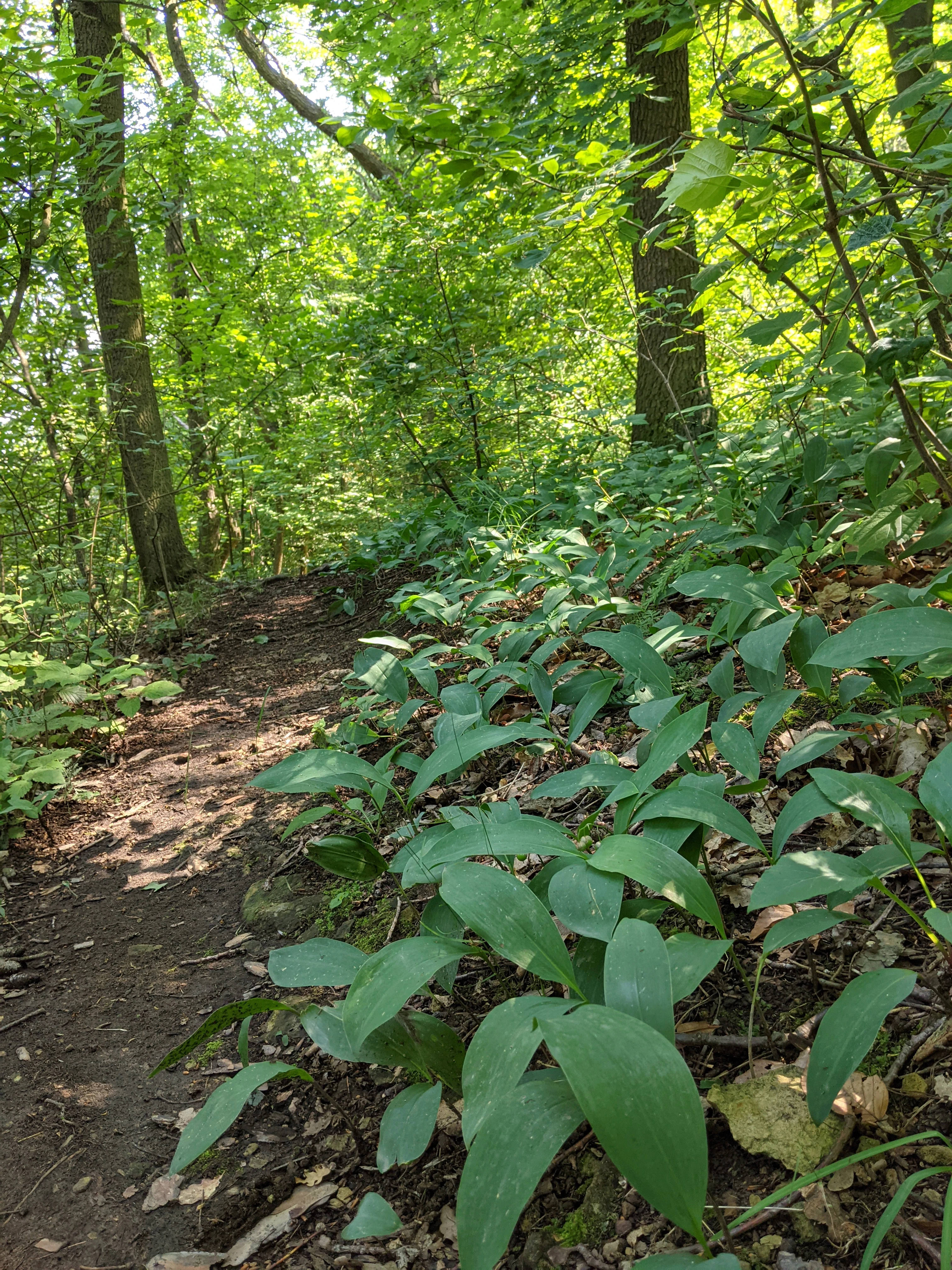
V hlubokém natural monument
The V hlubokém natural monument near Stradonice and Peruc in the Louny District.

V hlubokém history and protected-area timeline

V hlubokém was declared a natural monument on 24 February 1947 by the Ministry of Education and Enlightenment, at a time when the modern Czech system of small-scale protected areas was still being formalized. Its early designation reflects the recognition by mid-twentieth-century Czech botanists and naturalists that the opuka slopes above the Débeř valley supported an exceptional stand of thermophilic vegetation that warranted formal protection. Throughout the later twentieth century the site was managed primarily as a botanical reserve, with attention focused on preserving the open character of the sesleria grasslands and the rocky outcrops that anchor them. By the early 2000s, conservation planners at the regional level prepared a formal care plan for the period 2007 to 2016, addressing long-term management of the area. In recent decades, surveys have noted that several historically recorded species, including some rare orchids, have become difficult to find on site, and that many protected plants now survive mainly on adjacent rocks and slopes outside the strictly defined reserve boundary. Because of this shift, an extension of the protected area has been proposed, in order to capture the broader opuka slope complex and the additional populations of rare flora that have established beyond the original boundaries.

V hlubokém landscape and geographic character

The landscape of V hlubokém is defined by a wooded hillslope rising above the narrow Débeř valley, with elevations ranging from roughly 214 meters near the Débeřský stream to about 334 meters at the highest ridges within the reserve. The valley floor is shaped by the shallow stream, while the slopes above step up through forest, scattered outcrops, and small screes to rounded hilltops. The most visually distinctive element of the landscape is the open opuka outcrops that break through the canopy along the upper slope. Opuka is a soft, fine-grained calcareous rock, locally weathered into platforms, ledges, and rocky debris, and its pale, often yellowish appearance contrasts with the surrounding dark oak woodland and conifer plantings. Below the rocky crest, the terrain is cloaked in a light, open oak forest, frequently mixed with conifers, that gives way gradually to denser, more mesic woodland toward the stream. Small pools and ponds along the valley floor, just outside the strictly protected core, add wetland character to the broader Débeř landscape and complement the dry, sun-exposed habitats higher up the slope.

V hlubokém ecosystems, habitats, and plant life

Ecologically, V hlubokém is significant above all for its concentration of thermophilic and calcicole plant communities on a substrate that would normally be expected to support only ordinary Central Bohemian forest. The opuka rocks provide a base-rich, often drought-prone environment in which plant species more typical of warmer or more continental regions can survive together in one compact area. The defining vegetation type is a sesleria grassland built around Sesleria albicans, with Anthericum ramosum, Carex humilis, and Asperula tinctoria among the characteristic companions. On the very thinnest soils over rock, these open swards give way to low shrub communities dominated by Cotoneaster integerrimus, while on coarser scree a sparse open woodland of taller trees and shrubs develops, creating a layered pattern of open ground, scrub, and light woodland within a few tens of meters. This mosaic produces a high diversity of microhabitats. Warmer, drier patches on south-facing rock surfaces host sun-loving herbs and grasses, cooler pockets among the boulders retain more moisture and shade-tolerant species, and the transition into the surrounding oak woodland allows forest-edge species to intermingle with the calcicole grassland flora. The result is an unusually rich botanical gradient compressed into a small protected footprint.

V hlubokém wildlife and species highlights

Although V hlubokém is best known as a botanical site, its faunal interest is closely tied to the broader Débeř valley landscape. The mix of dry open rocks, sun-exposed scrub, light oak woodland, shaded forest, the Débeřský stream, and nearby ponds creates varied habitat conditions for invertebrates and vertebrates within a small area. The valley is reported as a refuge for numerous insect species, including a range of less common beetles and butterflies that benefit from the warm, flower-rich open habitats on the opuka slopes. The combination of rocky outcrops and surrounding flowering vegetation supplies both shelter and food resources for pollinator and thermophilic insect communities, which in turn support insectivorous birds and other predators. Amphibians are particularly visible in the small pond that adjoins the protected area: common toads, frogs including agile frogs, and the smooth newt occur there, using the standing water as a breeding site while foraging widely across the surrounding woodland and rocky slopes. The Débeř valley as a whole also supports a rich and varied bird community, making the area a well-rounded site of faunal interest despite its modest size and its botanical reputation.

V hlubokém conservation status and protection priorities

V hlubokém has been continuously protected since 1947, first as one of the earliest formally declared přírodní památky in what is now the Czech Republic. Its long protection history reflects a recognition, going back several generations, that the opuka slope above the Débeř valley supports plant communities of national significance that cannot survive without active conservation. The reserve is administered by the Czech Agency for Nature Conservation and Landscape Protection, which oversees habitat management and monitoring. Public access is allowed only along a forest path that connects with a forest track between Peruc and Stradonice, and regulations prohibit the destruction or disturbance of plants and animals within the protected area, in line with standard Czech natural monument rules. From a conservation perspective, the site matters because it preserves in compact form a vegetation type, the sesleria grassland on opuka, that is uncommon nationally and vulnerable to shrub encroachment, woodland overgrowth, and direct rock disturbance. Recent botanical surveys have raised concerns that several rare species, including some orchids recorded historically, have declined on site, and they have recommended extending the protected area to include surrounding opuka slopes where many of the same species continue to survive outside the current boundaries.

V hlubokém cultural meaning and human context

V hlubokém is primarily a natural heritage site and does not carry a strong cultural identity of its own, but its story is intertwined with the broader agricultural and woodland landscape of the Peruc and Stradonice area in the Louny district. The reserve sits within working forest that has long served local communities, and the fact that the area has been formally protected since 1947 reflects an early twentieth- and mid-twentieth-century tradition of Czech naturalists documenting and defending small but unusual botanical sites against land-use change. The Débeř valley itself is a recognized local natural landmark, regularly described in regional Czech publications and educational materials about the Louny district, and the reserve functions as a reference point for regional natural heritage. Its continued protection and the recurring local interest in its flora indicate that V hlubokém has become part of the informal cultural identity of this part of the Ústecký Region.

Top sights and standout views in V hlubokém

V hlubokém stands out as a compact example of how a single small protected area can preserve a complete ecological gradient, from open calcareous sesleria grasslands on opuka rock outcrops down through low cotoneaster-dominated scrub and into light oak woodland and the moist Débeř valley below. Its nationally distinctive vegetation, exceptionally early declaration date of 1947, and ongoing role as a refuge for rare thermophilic plants, amphibians, and valley birdlife together make it a classic reference site for Czech nature conservation beyond what its modest size would suggest.

Best time to visit V hlubokém

The ecological character of V hlubokém varies with the seasons in ways familiar from temperate Central European woodland reserves. Late spring and early summer usually offer the richest display of flowering thermophilic herbs and grasses on the opuka outcrops, when the sesleria swards and accompanying species such as Anthericum ramosum and Asperula tinctoria are at their most visible. Summer brings the densest vegetation cover, with open rock outcrops remaining warm and dry and amphibians active around the adjacent pond. Early autumn offers quieter conditions, leaf color in the surrounding oak woodland, and good opportunities to observe the broader Débeř valley and its birdlife. Access is limited to the marked forest path connecting to the track between Peruc and Stradonice, so visits are best planned for daylight hours in mild weather.


Monthly climate preview

Long-term temperature and precipitation patterns across representative coordinates

V hlubokém Climate Normals and Annual Temperature Rhythm

Representative coordinate records show measured monthly temperature variation ranging from freezing winter minimums to warm summer maximums alongside steady precipitation rates. Reviewing the complete twelve-month profile provides deeper insight into long-term climate normals and annual weather distribution across the terrain.
Annual mean8 °C
-3 °C19 °C
Jan-3°
Feb-1°
Mar
Apr
May13°
Jun17°
Jul19°
Aug18°
Sep13°
Oct
Nov
Dec-2°
Warmest month
July

18.7 °C

Coolest month
January

-2.6 °C

Wettest month
July

2.5 mm/day

Driest month
February

1.1 mm/day

Park location guide

Geography guide, regional context, and park location map for V hlubokém

V hlubokém park geography, regions, and map view in Czechia

Understand where V hlubokém sits in Czechia through a broader geographic reading of the surrounding landscape, nearby location context, and its mapped position within the national park landscape.

How V hlubokém fits into Czechia

Czech Republic is a landlocked Central European country with a population of approximately 10.9 million people. The nation was established as an independent state on January 1, 1993, following the dissolution of Czechoslovakia. Its capital and largest city is Prague, with other major urban centers including Brno, Ostrava, Plzeň, and Liberec.

Wider geography shaping V hlubokém in Czechia

The Czech Republic is a landlocked country in Central Europe. It is bordered by Germany to the west, Austria to the south, Poland to the northeast, and Slovakia to the southeast. The landscape is predominantly hilly, with the territory covering 78,871 square kilometers.

Map view of V hlubokém

Use this park location map to pinpoint V hlubokém in Czechia, understand its exact geographic position, and read its mapped placement within the surrounding landscape more clearly.

Pigeon | © OpenStreetMap contributors

Location context for V hlubokém

Ústecký kraj
Recorded earthquake history

Examine Recorded Earthquake History for the V hlubokém Protected Area

Review the curated history of seismic activity recorded in the vicinity of V hlubokém. MoriAtlas provides a clear catalogue of past events, allowing for the observation of regional earthquake patterns without implying predictive capability or hazard status for the natural monument.

V hlubokém Earthquake History

Catalogued events

10 events

Strongest magnitude

Magnitude 3.8

Most recent event

Nov 15, 2004

This history includes earthquakes recorded inside the park or within 50 km of its borders

Explore photographic records of rare thermophilic flora, wooded slopes, and calcareous terrain.

V hlubokém Photos and Landscape Scenery: Visualizing Opuka Rock Outcrops and Sesleria Grasslands

Visual documentation captures the steep opuka rock outcrops, open sesleria grasslands, and oak woodland habitats defining the terrain of V hlubokém. Photographic records illustrate the protected hillside environment above the Débeř valley, revealing botanical patterns across the calcareous reserve.

V hlubokém natural monument

Park atlas

Compare adjacent terrain, regional woodlands, and related calcareous reserves.

Explore Other Parks Near V hlubokém and Surrounding Protected Natural Areas

Continue browsing parks near V hlubokém to discover adjacent protected landscapes across the surrounding region. Comparing nearby natural monuments provides deeper context on regional topography and connected botanical reserves.
Nature reserveUstecky Region
7.8 km away#1 closest

North

Vrch Hazmburk Nature Reserve: Geographic Atlas and Protected Landscape Overview

Volcanic terrain and steppe ecosystems in the Ustecky Region

Vrch Hazmburk stands as a notable example of Neovolcanic geology, characterized by steep basalt slopes, frost-shattered cliffs, and a rich mosaic of dry grassland habitats. Located in the Ustecky Region, this protected site preserves a critical transition zone for thermophilic plants and rare invertebrates, offering a clear view of how geological movement and long-term land stability define the Bohemian lowland landscape.

Area
0.604 km²
Established
2011
IUCN
IV
Relief
Mountain
Natural monumentStředočeský kraj
9.9 km away#2 closest

Southwest

Smradovna Natural Monument: Geography and Protected Habitats in Central Bohemia

A protected stream valley system within the Stredocesky kraj region.

Smradovna preserves a unique concentration of lowland habitats, including calcareous beech forests and rare alkaline fens. This protected natural monument, located near Bilichov, is defined by its characteristic travertine springs and continuous stream-corridor ecosystem. Gain insight into the regional geography and botanical significance of this tightly knit protected landscape through our structured mapping and data.

Area
1.556 km²
Established
2014
IUCN
IV
Relief
Upland
Protected landscapeLitoměřice District
About 10 km away#3 closest

Northeast

Dolní Poohří Nature Park: Protected Landscape and River Geography

A riparian corridor through the Litoměřice District

The landscape of Dolní Poohří Nature Park follows the irregular arc of the lower Ohře River across the Bohemian plain. Its narrow boundaries protect a functional floodplain ecosystem characterized by silted oxbows, gravel banks, and rare forest fragments. This atlas entry details the geographic features, protected status, and the interplay between the active river channel and the historic townscapes found along its banks.

Area
40 km²
Established
2001
Relief
Lowland
Climate
Temperate
Natural monumentÚstecký kraj
11 km away#4 closest

East

Na Dlouhé stráni Natural Monument: Regional Protected Area and Botanical Landscape

A conservation-focused look at the Mšenský potok valley slope

Na Dlouhé stráni is a designated natural monument in the Czech Republic, renowned for its concentration of thermophilous grassland flora. This protected area, located near Mšené-lázně, preserves a specific slope habitat that supports declining plant species. The site offers an important look at regional conservation efforts and the mapping of small-scale protected habitats within the diverse Ústecký kraj geography.

Area
0.126 km²
Established
2012
IUCN
IV
Relief
Lowland
Natural monumentLitoměřice District
13 km away#5 closest

East

Vrbka Natural Monument: Exploring Protected Limestone Habitats and Bohemian Lowland Geography

A rare botanical reserve in the Litoměřice District of the Czech Republic

Vrbka Natural Monument protects a significant 15.5-hectare expanse of warm limestone slopes and dry meadows. This geographic landmark serves as an essential repository for rare orchid species and diverse insect populations, functioning as a representative habitat patch within the intensively cultivated landscapes of the surrounding region.

Area
0.155 km²
Established
2013
IUCN
IV
Relief
Upland
Nature reserveStředočeský kraj
About 13 km away#6 closest

South

Na Pilavě Nature Reserve: A Detailed Botanical Atlas of the Středočeský kraj Landscape

Mapping protected orchid habitats and forest flora in the Džbán highland.

Na Pilavě is a specialized nature reserve in the Kladno District, valued for its dense concentration of rare woodland orchids and the critically endangered black false hellebore. Set within the forested slopes of the Pilavské údolí, this protected area serves as a vital refuge for thermophilic plant communities and ancient deciduous forest flora.

Area
0.031 km²
Established
1969
IUCN
IV
Relief
Upland
Natural monumentStředočeský kraj
About 16 km away#7 closest

Southeast

Slánská hora Natural Monument: Volcanic Geography and Protected Hilltop Terrain in Central Bohemia

Detailed geological mapping of a Tertiary volcanic outlier and historic monument

Slánská hora functions as a significant geological landmark where basaltic vent remnants meet centuries of human history. This natural monument offers a window into the volcanic processes of the region through exposed columnar basalt and rock fissures. The site serves as a vital protected area, balancing remnants of warm-loving steppe vegetation and deciduous forest with the legacy of former quarries and ancient archaeological strata atop the Slaný ridge.

Area
0.022 km²
Established
1998
IUCN
III
Relief
Mountain
Natural monumentStředočeský kraj
18 km away#8 closest

South

Smečno Natural Monument: A Protected Woodland Ecosystem in Středočeský Kraj

Geography and conservation mapping in the Czech Republic

Located in the Kladno District, Smečno Natural Monument preserves mature deciduous trees essential for the survival of the hermit beetle. The site acts as a geographical link between distinct landform units, offering a clear look at how small, cavity-rich forest patches maintain ecological connectivity within the broader Central Bohemian landscape.

Area
0.772 km²
Established
2012
IUCN
IV
Relief
Upland

Common questions about visiting, size, designation, and location context for V hlubokém

V hlubokém FAQs for park facts, access, geography, and protected area context

Find quick answers about V hlubokém, including protected-area facts, park geography, trail and visitor context, and how the park fits into its surrounding country and regional landscape.
MoriAtlas Explorer

Continue Your Protected Areas Search Across the Global Atlas

Deepen your exploration by continuing the structured search for national parks and protected areas worldwide. Utilize the comprehensive filtering capabilities to compare different conservation landscapes and refine your understanding of global park geography. Discover more about the distribution and characteristics of protected natural areas.

Global natural geography