
Mori Atlas logo
Natural monumentV polích

A critical grassland site safeguarding orchid-rich meadow terrain in the Blanice valley

V polích Natural Monument: Mapping the Protected Meadow Landscapes of South Bohemia

V polích serves as a significant natural monument within the Jihočeský kraj, protecting vital grassland habitats on a south-east facing slope above the Blanice river. This site highlights the conservation of species-rich meadows that sustain declining flora in the Prachatice District. By analyzing its specific orientation and soil-climate conditions, visitors gain insight into the regional importance of these small-scale, managed protected landscapes within the broader Bohemian foothills.

orchid meadownatural monumentgrassland conservationspecies-rich meadowsouth BohemiaPrachatice District
A flat-style digital illustration depicting a wide, sunlit valley bordered by forested slopes, with a tall waterfall cascading down a sheer rock face in the background.

V polích

Natural monument

Park overview

Structured park overview, official facts, and landscape profile for V polích

V polích park facts, protected area profile, and essential visitor context

Review the core facts for V polích, including designation, size, terrain, visitor scale, habitats, and operating context in one park-focused overview.

About V polích

V polích is a modest but ecologically focused protected grassland in the South Bohemian Region of the Czech Republic, near the village of Zábrdí in the Prachatice District. It lies on the left side of the Blanice river valley, occupying part of a slope that tilts gently toward the south-east, where conditions of light, drainage, and traditional meadow use have created an environment especially well suited to native wildflowers.

The protected area is small, only about 1.68 hectares, and its scope is correspondingly narrow. Rather than trying to protect a large landscape or a wide range of habitats, V polích has been designated around a single conservation priority: the green-winged orchid, Anacamptis morio, known in Czech as the vstavač kukačka. This species, once widespread across European grasslands, has retreated sharply as traditional hay meadows have disappeared, and its surviving strongholds in Bohemia are increasingly important for the species' long-term future in the region.

What makes the site valuable ecologically is not simply the presence of the orchid, but the meadow habitat that supports it. The slope above the Blanice retains the character of a traditionally managed species-rich grassland, and during May it produces a flowering display that has become the defining image of the natural monument. Visitors, botanists, and conservationists come specifically to observe and document the Anacamptis morio populations, which give the meadow its particular identity and justify its protected status.

The site is officially classified as a přírodní památka, a category of Czech natural monument whose purpose is to safeguard specific natural features such as individual species, small habitat patches, or notable geological or ecological phenomena. V polích is registered in the national Central List of Nature Conservation under the code 1614 and is recognised under IUCN Category IV as a habitat or species management area. The natural monument was declared on 15 April 1992 by the District Office in Prachatice, reflecting local recognition of the meadow's importance long before it became part of broader regional conservation inventories.

Quick facts and research context for V polích

V polích is a Czech natural monument (přírodní památka) in the Prachatice District of the South Bohemian Region, established on 15 April 1992 by the former District Office in Prachatice. It covers approximately 1.68 hectares at an elevation of roughly 600 to 645 metres above sea level, on a south-east facing slope above the Blanice river near the village of Zábrdí u Lažišť. The site is classified under IUCN Category IV as a habitat or species management area, and its primary conservation target is the green-winged orchid, Anacamptis morio.

Protection and recognition

Explore documented terrestrial conservation scope and official status for V polích.

V Polích Protection Status and International Recognition Details

V polích holds a registered terrestrial protection scope within its designated conservation framework. Documented protection status details provide clear insight into the official management scope and administrative recognition of this protected area.

Protection details

Protection scope
Terrestrial
Transboundary protection
No
Park context

Deeper park guide and search-rich context for V polích

V polích history, landscape, wildlife, and travel context

Explore V polích through its history, landscape character, ecosystems, wildlife, conservation priorities, cultural context, and seasonal travel timing in a structured park guide built for atlas discovery and search intent.

Why V polích stands out

V polích is best known as the protected home of a thriving population of the green-winged orchid (Anacamptis morio), also known in Czech as the vstavač kukačka. In late spring, the south-east facing meadow slopes above the Blanice valley turn into a flowering display of this once-common but now declining European grassland orchid, and the whole natural monument is defined around preserving that phenomenon. Beyond its single star species, the site is recognised for the broader species-rich meadow habitat that supports Anacamptis morio, a grassland community increasingly rare in intensively farmed central Bohemia. The combination of a traditional, species-rich meadow with a protected legal status makes V polách a small but representative example of Czech orchid conservation.
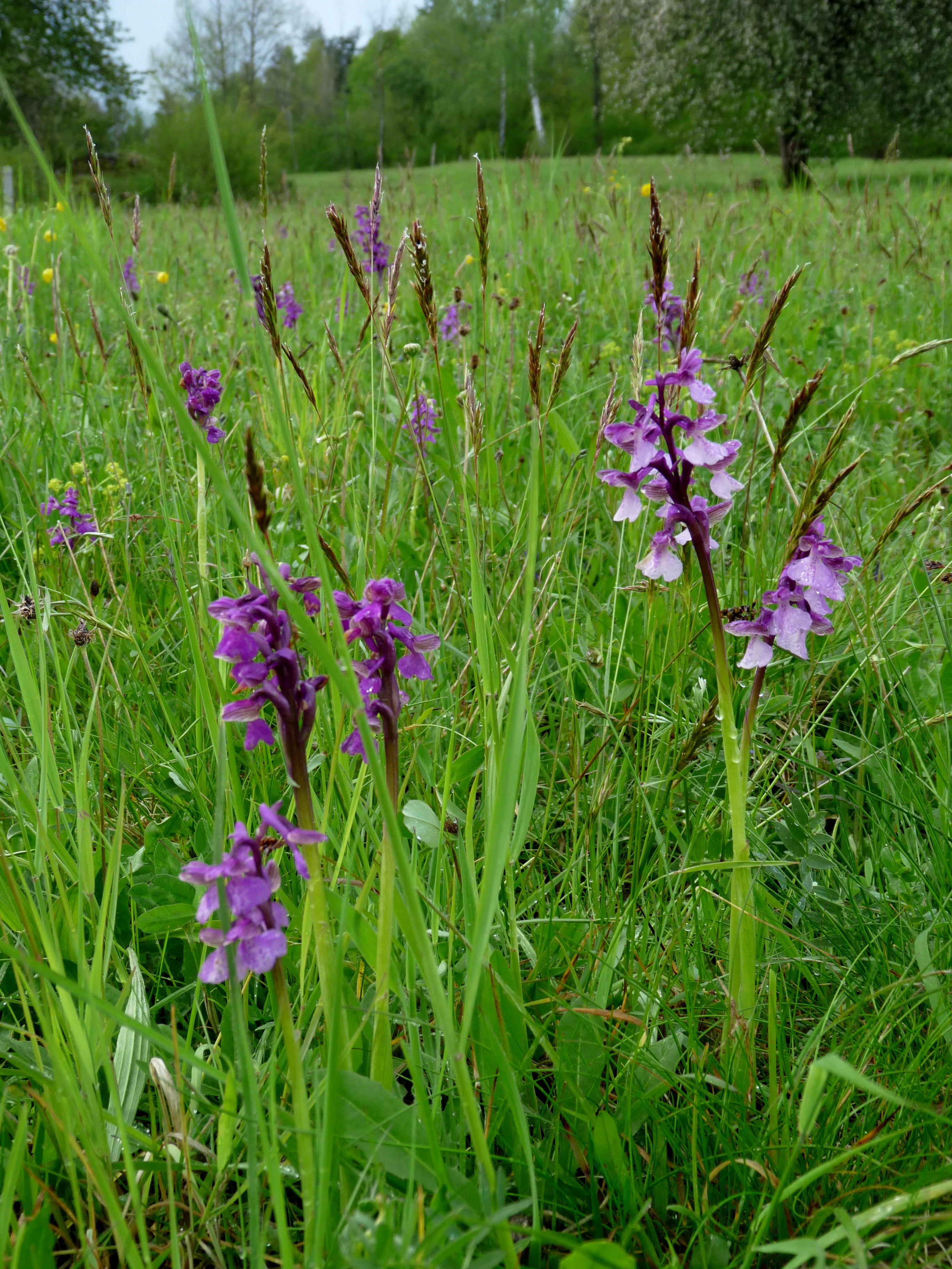
A cluster of purple green-winged orchids growing in a tall grassy meadow, with a background of trees.
A group of green-winged orchids, Anacamptis morio, blooming in the meadow of V polích natural monument.

V polích history and protected-area timeline

V polích was formally declared a protected site on 15 April 1992, when the District Office in Prachatice at that time established the area as a přírodní památka, a Czech category of natural monument. The protection was driven by the local significance of a meadow population of the green-winged orchid (Anacamptis morio), a species that has become increasingly rare across central Europe as traditional hay meadows have been lost.

Like many small Czech natural monuments, V polích reflects a tradition of identifying and protecting locally important natural features, rather than large-scale landscape reserves. Its designation placed the meadow on the national register of protected areas under the code 1614 and tied it to a long-running conservation effort to protect orchid-rich grasslands in the Prachatice District. The site is documented in the Czech Agency for Nature Conservation and Landscape Protection's regional inventory of the Českobudějovicko area, where it remains a recognised part of the broader network of meadow and grassland protections in South Bohemia.

V polích landscape and geographic character

V polích sits on a south-east oriented slope in the Blanice river valley, where the terrain is shaped by the river cutting through the Bohemian countryside. Rather than dramatic cliffs, deep gorges, or rugged ridges, the defining landscape character here is gentle: a slope tilting toward the sun, with meadow vegetation replacing forest cover, and views shaped more by openness and wildflowers than by elevation.

The site lies between about 600 and 645 metres above sea level, placing it in a cool upland band typical of the foothills and edges of the Bohemian highlands. The combination of slope angle, exposure, and elevation is significant because it creates the dry, sunny microclimate that the green-winged orchid and associated meadow species depend on. The Blanice river below marks the broader valley axis, while the protected upper portion of the slope adds the floral dimension that gives the site its name and its value.
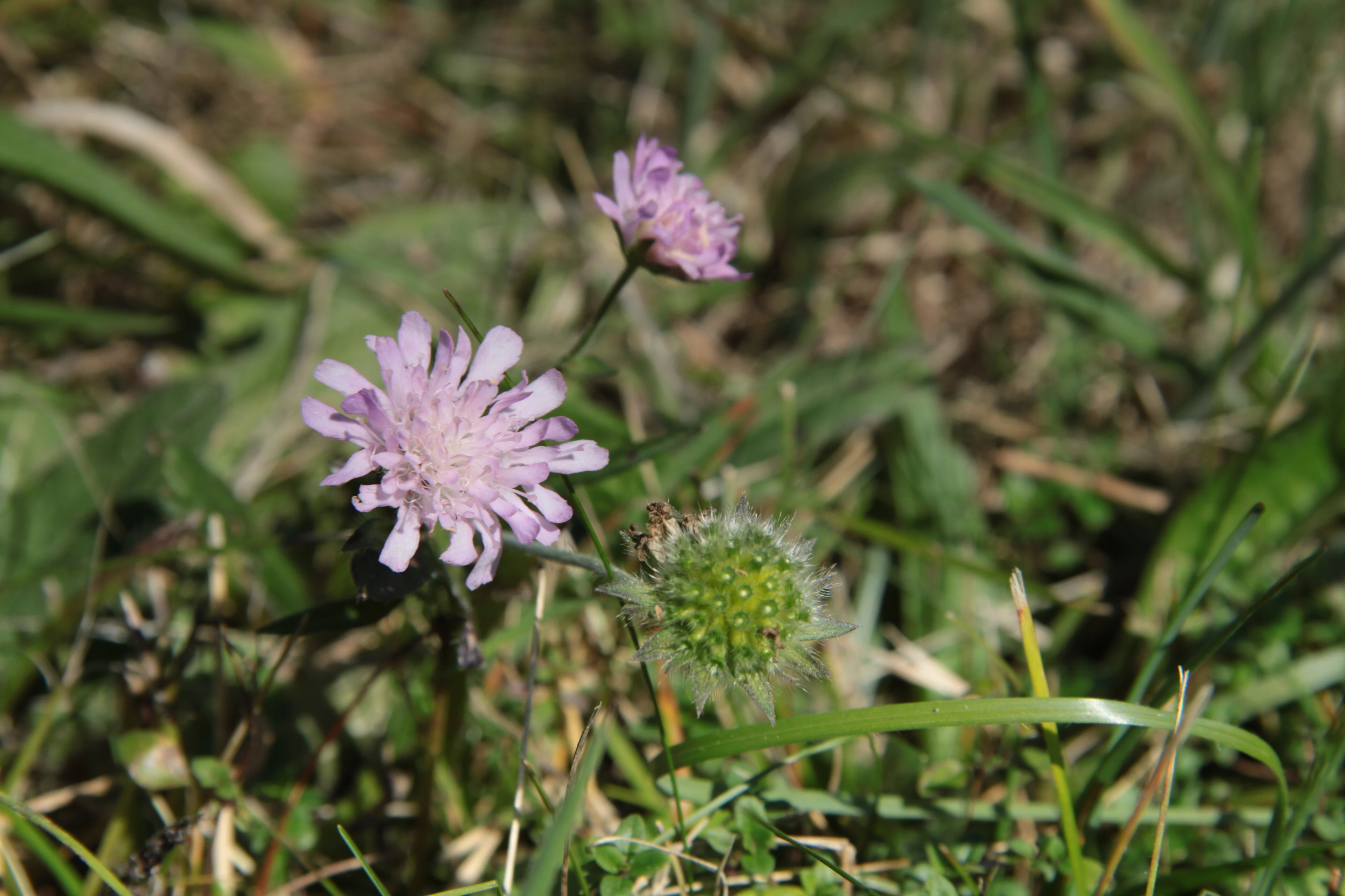
A close-up view of a pink field scabious flower in bloom with a green seed head and grass in the background.
Field scabious (Knautia arvensis) blooming in the meadow at the V polích natural monument.

V polích ecosystems, habitats, and plant life

The natural significance of V polích is inseparable from its meadow character. Although the protected territory is small, the habitat it conserves is genuinely distinctive: a surviving patch of traditional, species-rich, semi-dry grassland on a sun-facing slope. This kind of meadow supports a layered seasonal cycle, with early-spring greens giving way to a peak of flowering in May, when Anacamptis morio and associated wildflowers dominate the visual and ecological identity of the site.

Such meadow ecosystems in central Europe are not just individual species collections, but carefully balanced systems maintained by traditional mowing cycles, periodic grazing, or both. V polích belongs to that broader ecological world, where the survival of one notable plant often reflects the survival of dozens of less conspicuous species: grasses, sedges, dicots, and the invertebrates that depend on them.
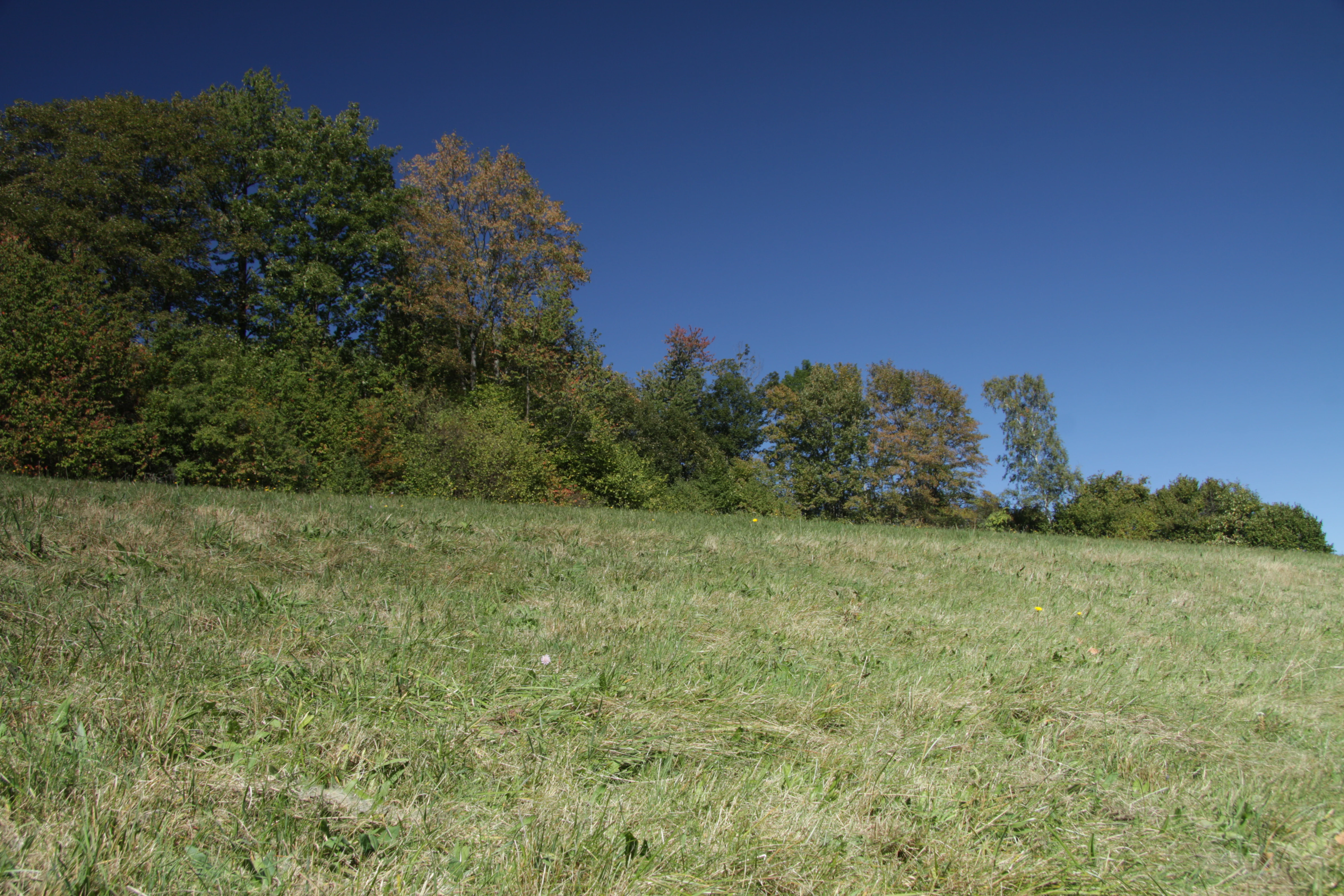
A wide, grassy meadow stretches towards a line of trees against a clear blue sky.
A view of the open meadow and forest edge at V polích natural monument.

V polích wildlife and species highlights

The wildlife profile of V polích is most strongly defined by its flagship botanical species, the green-winged orchid (Anacamptis morio), rather than by charismatic larger animals. This orchid is the central reason the site is protected, and the late-May flowering of its populations is the most visible wildlife event of the year.

Beyond the orchid, the meadow environment supports the typical invertebrate community of species-rich central European hay meadows, including pollinators such as bees, butterflies, and other insects that benefit from the nectar and structural diversity of the meadow flora. Documentation also notes the presence of Knautia arvensis (field scabious, in Czech chrastavec rolní), a characteristic meadow species that supports the broader pollinator community and signals the meadow's semi-natural origin.

V polích conservation status and protection priorities

V polích matters from a conservation perspective because it protects one of the more important Czech populations of Anacamptis morio, a species that has declined steeply across Europe as traditional hay meadows have been replaced by more intensive land use or allowed to fall into scrub.

The protection is therefore not symbolic. It is aimed at maintaining the specific combination of slope, exposure, soil, and traditional management that allows the orchid to persist, and at preventing the rapid habitat changes that have eliminated the species from many similar sites elsewhere in central Bohemia. Classified as a přírodní památka and registered as an IUCN Category IV area, V polích forms part of the fine-grained infrastructure of small protected sites that, together, preserve the remaining orchid-rich grasslands of the region.

V polích cultural meaning and human context

The site reflects the long Central European tradition of small, locally declared natural monuments that protect ecologically valuable patches of land tied to traditional rural land use. The use of the name V polích, meaning "in the fields," reflects the cultural understanding of the landscape as a working agricultural setting whose value lies in its continued functioning as a meadow rather than as wilderness.

This pattern of protection, tied to specific places where rare wildflowers persist alongside farming activity, is characteristic of the Czech and broader Bohemian approach to nature conservation, and V polích is a small but representative example of that landscape philosophy.

Top sights and standout views in V polích

V polích is a small but information-rich protected site: a south-east facing meadow slope above the Blanice river, dedicated to one of the few strong remaining populations of the green-winged orchid (Anacamptis morio) in the Prachatice District. Its highlights are the late-May flowering display of Anacamptis morio, the species-rich hay-meadow habitat that supports it, and the broader conservation significance of safeguarding orchid-rich grasslands in South Bohemia.

At the same time, the site's compact scale, clear single-species focus, and integration into a network of similar small protected meadows mean it is best understood as part of a regional conservation pattern, rather than a destination in its own right.

Best time to visit V polích

V polích is essentially a seasonal site, and the period that matters most is mid to late May, when Anacamptis morio reaches its flowering peak across the protected slope. Visiting in this window offers the strongest chance of seeing the orchid populations that define the site.

Outside of May, the meadow still has interest: later in the year the grasses and other meadow plants dominate, and by autumn the site takes on the character of a typical late-season hay meadow. Spring, however, remains the clear centre of the site's identity for anyone interested in understanding why it is protected.


Monthly climate preview

Long-term representative point measurements for V polích across twelve months

V polích Climate Normals, Measured Annual Temperature and Precipitation Rhythms

Representative point measurements for V polích reveal an annual temperature rhythm spanning from freezing winter minimums to warm summer maximums alongside steady daily precipitation averages. Opening the complete monthly dataset provides detailed long-term climate normals, average temperatures, and precipitation values.
Annual mean7 °C
-3 °C18 °C
Jan-3°
Feb-2°
Mar
Apr
May12°
Jun16°
Jul18°
Aug17°
Sep13°
Oct
Nov
Dec-2°
Warmest month
July

17.5 °C

Coolest month
January

-3.4 °C

Wettest month
June

3.3 mm/day

Driest month
April

1.6 mm/day

Park location guide

Geography guide, regional context, and park location map for V polích

V polích park geography, regions, and map view in Czechia

Understand where V polích sits in Czechia through a broader geographic reading of the surrounding landscape, nearby location context, and its mapped position within the national park landscape.

How V polích fits into Czechia

Czech Republic is a landlocked Central European country with a population of approximately 10.9 million people. The nation was established as an independent state on January 1, 1993, following the dissolution of Czechoslovakia. Its capital and largest city is Prague, with other major urban centers including Brno, Ostrava, Plzeň, and Liberec.

Wider geography shaping V polích in Czechia

The Czech Republic is a landlocked country in Central Europe. It is bordered by Germany to the west, Austria to the south, Poland to the northeast, and Slovakia to the southeast. The landscape is predominantly hilly, with the territory covering 78,871 square kilometers.

Map view of V polích

Use this park location map to pinpoint V polích in Czechia, understand its exact geographic position, and read its mapped placement within the surrounding landscape more clearly.

Pigeon | © OpenStreetMap contributors

Location context for V polích

Jihočeský kraj

Explore detailed imagery of the terrain, wildflower slopes, and natural monument environment.

V polích Photos and Landscape Scenery: Visualizing the Protected Meadow Habitat

Visual documentation captures the south-east facing meadow slopes and rare orchid habitats defining V polích. Examining these protected area photographs reveals the terrain, vegetation patterns, and microclimate characteristics of the Blanice river valley.

A cluster of purple green-winged orchids growing in a tall grassy meadow, with a background of trees.

A group of purple-flowered green-winged orchids growing in a grassy meadow with mixed wildflowers and trees in the background.

A close-up view of a pink field scabious flower in bloom with a green seed head and grass in the background.

A wide, grassy meadow stretches towards a line of trees against a clear blue sky.

Park atlas

Compare nearby regional reserves and connected grassland habitats

Explore Parks Near V Polích And Surrounding Protected Areas

Continue exploring protected areas near V polích by browsing adjacent regional reserves and river valley habitats. Comparing surrounding grassland conservation sites reveals broader patterns of upland flora across the district.
A horizontal watercolor illustration depicting rolling green hills in the background, a line of trees in the midground, and a grassy meadow with small white flowers in the foreground.
Natural monumentPrachatice District
About 14 km away#1 closest

East

Mastnice Natural Monument: Protected Stream Valley and Wetland Habitat in Prachatice District

Ecologically significant wet meadow and valley geography in the Czech Republic

Mastnice is a protected natural monument situated within the Prachatice District, characterized by its waterlogged meadows and damp woodland margins along a stream valley. This site serves as a key botanical reserve, offering a rare look at valley wetland ecosystems that provide essential habitats for seasonal flora and diverse local species in the South Bohemian region.

Area
0.011 km²
Established
1988
IUCN
IV
Relief
Upland
Watercolor illustration of a river flowing through a forested landscape with rolling hills in the background
National parkSouth Bohemian Region
About 14 km away#2 closest

West

Šumava National Park: Czech Republic's Premier Forested National Park and Protected Landscape

Explore the unique glacial lakes, peat bogs, and regional geography.

Šumava National Park, situated in the South Bohemian Region of the Czech Republic, is the nation's largest protected area and a vital component of Central Europe's forest ecosystems. This entry details its expansive terrain, highlighting the significant peat bog complexes and ancient glacial lakes that define its unique landscape. Discover the park's geographic context, mapped boundaries, and its importance as a protected natural asset within the broader regional atlas.

Area
680.64 km²
Established
1991
IUCN
II
Visitors
2M annual
Watercolor painting of a soft, panoramic landscape with rolling green hills, a gentle path or stream, and misty mountain silhouettes in the background under a pale sky.
Natural monumentStrakonice District
About 15 km away#3 closest

North

Na Opukách Natural Monument: Protected Calcareous Landscapes in Strakonice District

Botanical richness and geological geography of a unique Bohemian hilltop reserve

Na Opukách protects a specialized environment of dry grassland and opuka outcrops that remain rare within the wider Strakonice foothills. This site provides a focused look at how specific sedimentary geology supports diverse orchid populations and hardy meadow flora within a predominantly forested regional geography.

Area
0.348 km²
Established
1996
IUCN
IV
Relief
Upland
A watercolor painting showing a panoramic view of a green wetland area with trees, grass, and rolling hills in the background.
Nature reserveJihočeský kraj
About 18 km away#4 closest

West

Pravětínská Lada Nature Reserve: Geography and Protected Area Landscape Context

Wetland mosaics and peat bog terrain in the South Bohemian Region

Pravětínská Lada serves as a vital protected landscape where peatland and spring headwater ecosystems meet recovering farmland. Located in the Jihočeský kraj, this nature reserve demonstrates how small-scale terrain variations and moisture gradients support high ecological density within the wider Bohemian Forest. The site provides a concentrated look at the transitional boundary between wetland communities and secondary meadows.

Area
0.516 km²
Established
2000
IUCN
IV
Relief
Upland
A watercolor painting of a rolling mountain landscape with forests, depicted in varying tones of green, orange, and purple, set against a white background.
Nature reserveJihočeský kraj
About 22 km away#5 closest

Southeast

Ptačí stěna Nature Reserve: Mapped Geographic Profile of South Bohemian Protected Forests

Granulite cliff landforms and submontane beech forest mapping.

Ptačí stěna Nature Reserve occupies a steep southwestern slope in the Blanský les, defined by a linear granulite frost-riven cliff and a vast talus field of boulders up to three meters across. This protected area showcases the interplay between mature 150-year-old beech woodlands and rugged, cool microhabitats that support unique species. The site serves as a vital example of layered forest and rock conservation in South Bohemia.

Area
0.205 km²
Established
1996
IUCN
IV
Relief
Mountain
A horizontal watercolor illustration depicting soft, rolling green hills and distant pink-toned mountain silhouettes against a white background.
Natural monumentJihočeský kraj
About 24 km away#6 closest

Southeast

Na Stráži Natural Monument: Protected Grassland Geography in the Czech Republic

A botanically significant meadow in the South Bohemian landscape

Na Stráži is an important natural monument situated on a steep hillside in the Jihočeský kraj region. Known for its population of green-winged orchids and unique thermophilous acidophilic grasslands, this protected meadow provides a critical example of small-scale habitat conservation within the larger Blanský les protected landscape.

Area
0.037 km²
Established
1993
IUCN
IV
Relief
Upland
Watercolor painting showing mountains, forests, and valleys in a landscape.
National parkGermany
About 24 km away#7 closest

West

Bavarian Forest National Park: Protected Landscape and Regional Geography Atlas

Explore mapped terrain and protected park boundaries in Germany.

Dive into the specifics of Bavarian Forest National Park, a key protected area noted for its distinct landscape and geographic importance. This MoriAtlas entry details the park's mapped boundaries and its setting within the surrounding regional geography, offering a clear atlas-style view of its natural terrain. Understand its identity as a national park and discover its place in Germany's protected lands.

Area
242.45 km²
Established
1970
IUCN
II
Visitors
1.3M annual
Watercolor painting of a grassy meadow bordered by a forest line with soft green and muted earth tones.
Nature reserveJihočeský kraj
About 24 km away#8 closest

West

Rašeliniště u Martinala: A Protected Nature Reserve in the Jihočeský kraj Foothills

Mapping transitional bog ecosystems and submontane habitats

Located in the Šumava foothills, Rašeliniště u Martinala is a protected nature reserve defined by its dual-parcel structure of peat-forming wetlands and juniper-rich dry grasslands. This site acts as a key ecological node, supporting a high density of protected species within the Jáchymovský potok drainage basin and representing a refined example of south Bohemian submontane landscape character.

Area
0.095 km²
Established
2011
IUCN
IV
Relief
Upland

Common questions about visiting, size, designation, and location context for V polích

V polích FAQs for park facts, access, geography, and protected area context

Find quick answers about V polích, including protected-area facts, park geography, trail and visitor context, and how the park fits into its surrounding country and regional landscape.
MoriAtlas Explorer

Continue Your Protected Areas Search Across the Global Atlas

Deepen your exploration by continuing the structured search for national parks and protected areas worldwide. Utilize the comprehensive filtering capabilities to compare different conservation landscapes and refine your understanding of global park geography. Discover more about the distribution and characteristics of protected natural areas.

Global natural geography