Mori Atlas logo
Biosphere reserveValles del Jubera, Leza, Cidacos y Alhama

A biosphere reserve defined by four dramatic river valleys and deep limestone gorges

Valles del Jubera, Leza, Cidacos y Alhama: Exploring the Protected Geography of La Rioja

(Reserva de la Biosfera de los Valles del Jubera, Leza, Cidacos y Alhama)

Valles del Jubera, Leza, Cidacos y Alhama encompasses a vast protected area in the Iberian System foothills of La Rioja. This territory is characterized by deep river incisions, limestone ravines, and significant paleontological sites that track prehistoric life. The landscape integrates Mediterranean forest ecosystems with centuries of traditional agricultural terraces and historic hilltop settlements, forming a complex terrain where natural processes and rural heritage overlap.

biosphere reserveriver valleyslimestone gorgesMediterranean forestmid-mountain landscapedinosaur tracks

Valles del Jubera, Leza, Cidacos y Alhama

Biosphere reserve

Park overview

Structured park overview, official facts, and landscape profile for Valles del Jubera, Leza, Cidacos y Alhama Biosphere Reserve

Valles del Jubera, Leza, Cidacos y Alhama Biosphere Reserve park facts, protected area profile, and essential visitor context

Review the core facts for Valles del Jubera, Leza, Cidacos y Alhama Biosphere Reserve, including designation, size, terrain, visitor scale, habitats, and operating context in one park-focused overview.

About Valles del Jubera, Leza, Cidacos y Alhama Biosphere Reserve

Valles del Jubera, Leza, Cidacos y Alhama stands as one of the most distinctive protected landscapes in northern Spain, defined by the parallel descent of four river systems through the southern part of La Rioja. The territory gathers the valleys of the Jubera, Leza, Cidacos, and Alhama rivers, which flow from the higher ridges of the Iberian System toward the Ebro basin. Their combined basins form a coherent landscape of deep gorges, limestone shelves, forested slopes, dry-farming terraces, and small hill villages that together create the reserve's identity.

Although the area is officially a biosphere reserve rather than a national park, its scale and ecological richness place it among the most substantial protected-area designations in the region. The reserve is managed to balance conservation with the needs of the rural communities living within it. About 10,000 people reside across more than thirty municipalities whose economies remain closely tied to the land through dryland agriculture, livestock grazing, and small-scale forestry. Many of these traditions, including terraced fields, dehesa-style woodlands, and pastoral routes, have shaped the reserve's appearance over centuries.

The area's geological character is one of its most important features. The valleys cut through calcareous formations that produce both the dramatic cliffs of the reserve and the thermal springs for which localities like Arnedillo are known. Within the Cidacos valley, the soft sediments of ancient floodplains now preserve extensive tracks of dinosaurs, creating one of Europe's most important ichnological corridors. The reserve also safeguards archaeological traces of Celtiberian culture, including hill settlements that reflect millennia of human presence.

Quick facts and research context for Valles del Jubera, Leza, Cidacos y Alhama Biosphere Reserve

Valles del Jubera, Leza, Cidacos y Alhama is a UNESCO biosphere reserve located in the autonomous community of La Rioja, northern Spain. It covers 119,669 hectares, approximately 24 percent of the regional territory, and is divided into a 5,537-hectare core zone, a 11,760-hectare buffer zone, and a 102,372-hectare transition zone. The reserve was designated on 9 July 2003 and encompasses the valleys of the Jubera, Leza, Cidacos, and Alhama rivers, along with 27 fully included municipalities and 13 partially included ones.

Protection and recognition

Documented protected area designations and international recognition records

Valles del Jubera, Leza, Cidacos y Alhama Protection Status and UNESCO Recognition

Valles del Jubera, Leza, Cidacos y Alhama holds official UNESCO biosphere reserve recognition within its documented conservation framework. Structured protection records detail international designation data and administrative recognition sources for the protected landscape.
Park context

Deeper park guide and search-rich context for Valles del Jubera, Leza, Cidacos y Alhama Biosphere Reserve

Valles del Jubera, Leza, Cidacos y Alhama Biosphere Reserve history, landscape, wildlife, and travel context

Explore Valles del Jubera, Leza, Cidacos y Alhama Biosphere Reserve through its history, landscape character, ecosystems, wildlife, conservation priorities, cultural context, and seasonal travel timing in a structured park guide built for atlas discovery and search intent.

Why Valles del Jubera, Leza, Cidacos y Alhama Biosphere Reserve stands out

The biosphere reserve is especially known for the convergence of four deeply incised river valleys in a single protected area. Its limestone gorges, known locally as cortados, form dramatic cliffs and ravines that have long attracted speleologists and naturalists. The reserve is also notable for preserving one of the richest concentrations of dinosaur trace fossils in Europe, with numerous ichnite sites scattered across the Cidacos valley. Combined with heritage such as Celtiberian hilltop villages and thermal springs, the reserve presents a landscape where paleontology, geology, and traditional rural culture coexist within a Mediterranean mountain setting.
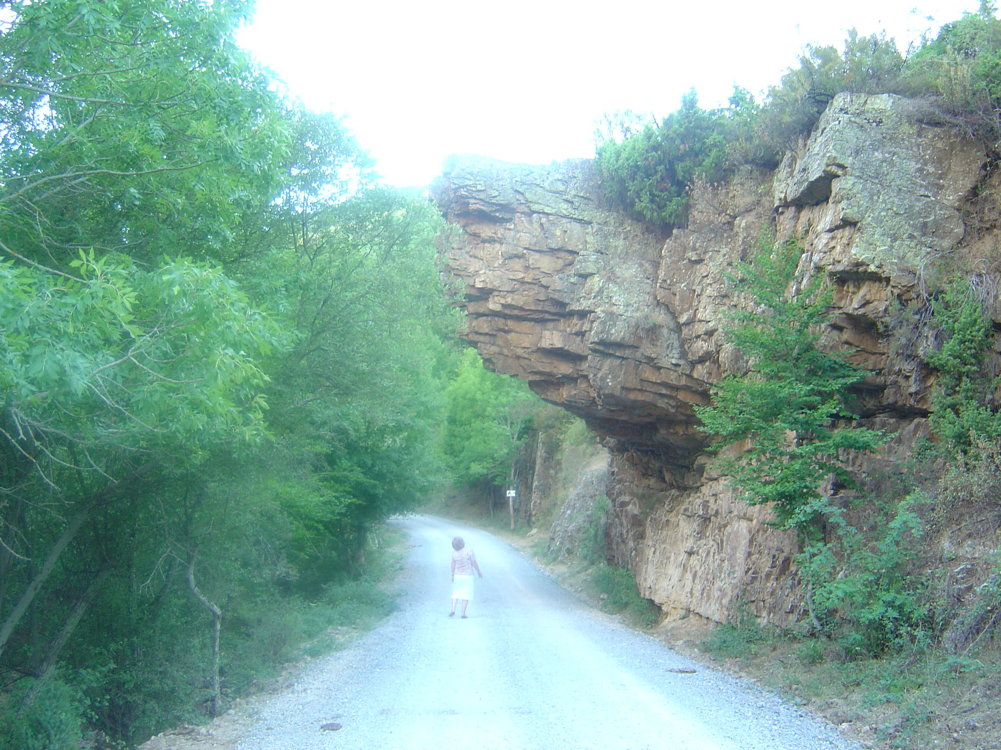
A person walks on a gravel path beneath a large, protruding rock ledge surrounded by green trees.
A narrow path passing beneath a prominent rock overhang near Ajamil in the Valles del Jubera, Leza, Cidacos y Alhama biosphere reserve.

Valles del Jubera, Leza, Cidacos y Alhama Biosphere Reserve history and protected-area timeline

The reserve was formally designated as a UNESCO biosphere reserve on 9 July 2003, following recognition that the valleys of the Jubera, Leza, Cidacos, and Alhama combined exceptional natural and cultural values. The designation brought together an area that had already attracted scientific and public attention for its dinosaur track sites, its thermal springs at Arnedillo, and its rural heritage tied to the traditional villages of the Camero region.

The divisions of the reserve, a 5,537-hectare core zone, a 11,760-hectare buffer zone, and a 102,372-hectare transition zone, were structured to keep the strictest protection in the most ecologically sensitive areas while allowing continued economic activity in the parts of the territory that include inhabited villages. Additional protection layers overlap with parts of the reserve, including several Special Protection Areas for birds that have been recognized under European Union nature directives.

Beyond the modern designation, the valley has a long human history. Celtiberian communities occupied hilltop sites such as those at Inestrillas and Contrebia Leukade, leaving behind place names, settlements, and other archaeological evidence that remain embedded in the cultural landscape of the protected area.

Valles del Jubera, Leza, Cidacos y Alhama Biosphere Reserve landscape and geographic character

The landscape of the biosphere reserve is shaped first by its four river valleys. The Jubera, Leza, Cidacos, and Alhama rivers run roughly parallel through the southern portion of La Rioja, incising deep ravines into the limestone bedrock and producing cliffs, galleries, and narrow gorges that define much of the reserve's scenery.

Above these valleys rises a mid-mountain relief that ranges from around 450 meters in the lower valleys up to approximately 1,758 meters at the highest points. Slopes alternate between open pasture, cereal fields, and forested hillsides. Dryland agriculture has refined much of the land into terraces, vega floodplain gardens, and other cultivated forms. The combination of river-cut rock, agricultural steps, and forested ridges creates a varied terrain typical of the Iberian System foothills.

Valles del Jubera, Leza, Cidacos y Alhama Biosphere Reserve ecosystems, habitats, and plant life

The vegetation of the reserve reflects a Mediterranean mountain mosaic shaped by altitude, aspect, and traditional land use. On the sunnier slopes, holm oak, oak, and Scots pine form the backbone of the forested landscape, accompanied by patches of more demanding species such as beech and Portuguese oak in the higher, cooler zones.

Beneath the tree canopy lie extensive areas of low shrubland dominated by juniper and rockrose, along with open pastures used for livestock grazing. The dryland fields scattered across the reserve, including cereals, vineyards, and small kitchen gardens along the vega, add an agricultural layer to the ecological mosaic. Across this variety of habitats, the reserve sustains a rich and diverse fauna, with particular importance for steppe and cliff-nesting bird species.

Valles del Jubera, Leza, Cidacos y Alhama Biosphere Reserve wildlife and species highlights

Because the reserve overlaps with several designated bird protection areas, including Peñas del Iregua, Jubera y Leza, Peñas de Arnedillo, Peña Isasa y Peñalmonte, and Sierra de Alcarama y Valle del Alhama, its cliffs and open landscapes are notable for birdlife. These cliffs support raptors and other cliff-nesting species, while the steppe-like agricultural areas and shrublands host bird communities typical of Mediterranean mountain interiors.

Larger mammals typical of the Iberian mid-mountains are present in the reserve's forests and rocky terrain, and the rivers themselves maintain associated riparian fauna. The dinosaur tracks preserved in the Cidacos valley, while not a living wildlife feature, are an essential component of the reserve's natural heritage and are managed as a paleontological resource.

Valles del Jubera, Leza, Cidacos y Alhama Biosphere Reserve conservation status and protection priorities

The reserve is managed as a biosphere reserve under UNESCO's Man and the Biosphere programme, with a tiered zoning system designed to reconcile ecological protection with the presence of inhabited villages and economic activity. The 5,537-hectare core zone concentrates the strictest protection, the 11,760-hectare buffer zone provides a transition, and the 102,372-hectare transition zone accommodates most of the human presence, agricultural land, and rural settlements.

Overlapping protection layers strengthen the reserve's conservation profile. Parts of the territory are included in Special Protection Areas for birds, which are recognized under European Union nature directives and add an additional layer of legal protection. The reserve thus combines landscape-scale biodiversity conservation with the safeguarding of cultural heritage, paleontological sites, and traditional land-use systems.

Valles del Jubera, Leza, Cidacos y Alhama Biosphere Reserve cultural meaning and human context

The valleys encompassed by the reserve carry a deep and continuous human history. Celtiberian communities established settlements on strategic heights such as the ancient site of Contrebia Leukade near Aguilar del Río Alhama, and other archaeological remains are scattered across the four valleys. This pre-Roman heritage remains an essential element of the region's identity.

In more recent centuries, the land has been shaped by mountain villages of the Camero region and the agricultural and pastoral practices of La Rioja's southern valleys. Terraced agriculture, transhumant grazing, and dryland cereal cultivation have all left visible marks on the landscape. Today the reserve supports a living rural culture of roughly 10,000 inhabitants across 27 fully included municipalities and 13 partially included ones.

Top sights and standout views in Valles del Jubera, Leza, Cidacos y Alhama Biosphere Reserve

Among the reserve's most distinctive features are the four parallel river valleys that give it its name, each cutting dramatic limestone gorges through the Iberian System foothills. The area's paleontological value is exceptional: the Cidacos valley preserves one of Europe's most important concentrations of dinosaur trace fossils, with sites such as those around Enciso regularly drawing visitors. The thermal springs of Arnedillo add a hydrological highlight, while hilltop Celtiberian villages and the quiet rural landscapes of the Camero area provide a strong cultural counterpoint.

Best time to visit Valles del Jubera, Leza, Cidacos y Alhama Biosphere Reserve

Spring and autumn are generally the most rewarding seasons to experience the reserve. Spring brings fresh greenery in the forests and flowering shrublands, while autumn colors the broadleaf woodlands and coincides with harvest activity in the dry-farming villages. Summer remains appealing for the cooler temperatures of the mid-mountain landscape, though higher areas receive intense sun, and winter can bring snow to the highest elevations above 1,500 meters, leaving the valleys quieter and more atmospheric.
Monthly climate preview

Long term temperature and precipitation cycles across twelve representative months

Valles del Jubera, Leza, Cidacos y Alhama Climate Normals and Annual Weather Patterns

Representative coordinate measurements trace the measured annual temperature and precipitation rhythm across Valles del Jubera, Leza, Cidacos y Alhama. Complete twelve month normals and detailed monthly comparisons remain available through the dedicated climate profile route.
Annual mean12 °C
4 °C21 °C
Jan
Feb
Mar
Apr10°
May14°
Jun18°
Jul21°
Aug21°
Sep17°
Oct13°
Nov
Dec
Warmest month
August

21.2 °C

Coolest month
January

3.8 °C

Wettest month
April

1.7 mm/day

Driest month
August

0.7 mm/day

Park location guide

Geography guide, regional context, and park location map for Valles del Jubera, Leza, Cidacos y Alhama Biosphere Reserve

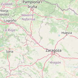
Valles del Jubera, Leza, Cidacos y Alhama Biosphere Reserve park geography, regions, and map view in Spain

Understand where Valles del Jubera, Leza, Cidacos y Alhama Biosphere Reserve sits in Spain through a broader geographic reading of the surrounding landscape, nearby location context, and its mapped position within the national park landscape.

How Valles del Jubera, Leza, Cidacos y Alhama Biosphere Reserve fits into Spain

Spain, officially the Kingdom of Spain, is a unitary parliamentary constitutional monarchy located in Southern and Western Europe. The country occupies most of the Iberian Peninsula and includes territories in the Mediterranean and Atlantic. With a population of approximately 49.6 million and an area of 506,030 km², Spain is a major European economy and cultural force. Its capital is Madrid, and the country is known for its diverse landscapes ranging from mountainous regions to coastal areas.

Wider geography shaping Valles del Jubera, Leza, Cidacos y Alhama Biosphere Reserve in Spain

Spain occupies the Iberian Peninsula in Southern and Western Europe. Peninsular Spain is bordered to the north by France, Andorra, and the Bay of Biscay; to the east and south by the Mediterranean Sea and Gibraltar; and to the west by Portugal and the Atlantic Ocean. The territory includes the Canary Islands in the Atlantic Ocean, the Balearic Islands in the Mediterranean Sea, and the autonomous cities of Ceuta and Melilla in mainland Africa. Spain features diverse terrain including the Pyrenees in the northeast, the Sierra Nevada in the south, and the Meseta Central plateau.

Map view of Valles del Jubera, Leza, Cidacos y Alhama Biosphere Reserve

Use this park location map to pinpoint Valles del Jubera, Leza, Cidacos y Alhama Biosphere Reserve in Spain, understand its exact geographic position, and read its mapped placement within the surrounding landscape more clearly.

Pigeon | © OpenStreetMap contributors

Location context for Valles del Jubera, Leza, Cidacos y Alhama Biosphere Reserve

La Rioja
Recorded earthquake history

Review the Recorded Earthquake History for the Biosphere Reserve

Explore the historical catalogue of seismic events associated by proximity with Valles del Jubera, Leza, Cidacos y Alhama. This MoriAtlas dataset provides a factual record of past activity to support deeper geographic discovery within this La Rioja landscape.

Valles del Jubera, Leza, Cidacos y Alhama Earthquake History

Catalogued events

21 events

Strongest magnitude

Magnitude 3.5

Most recent event

Jun 19, 2007

This history includes earthquakes recorded inside the park or within 50 km of its borders

Visual exploration of limestone gorges, parallel river valleys, and mid-mountain habitats

Valles del Jubera, Leza, Cidacos y Alhama Photos and Protected Landscapes

Visual records capture the deep river canyons, sheer limestone cliffs, and Mediterranean forest canopies that define the protected terrain of Valles del Jubera, Leza, Cidacos y Alhama. Studying these field photographs helps researchers evaluate regional topography, geological formations, and traditional land-use patterns across the reserve.

A person walks on a gravel path beneath a large, protruding rock ledge surrounded by green trees.

Park atlas

Compare surrounding regional geography and adjacent protected areas in northern Spain

Parks Near Valles del Jubera, Leza, Cidacos y Alhama And Related Protected Landscapes

Visitors exploring Valles del Jubera, Leza, Cidacos y Alhama can examine adjacent protected areas and nearby national parks with similar mountain terrain. Comparing these surrounding reserves reveals broader regional geographic patterns and connected conservation landscapes.
A horizontal watercolor illustration showing soft, stylized hills, valleys, and forest patches in muted greens, pinks, and yellows.
Protected landscapeCastilla y León
63 km away#1 closest

West

Sabinares del Arlanza-La Yecla: A Detailed Protected Landscape and Map of Burgos

Ancient juniper woodlands and deep limestone ravines in Castilla y León.

This protected area centers on the remarkable juniper forests and the narrow, vertical walls of the La Yecla gorge. The landscape serves as an essential habitat for cliff-nesting raptors while bridging the terrain between the Sierra de la Demanda foothills and the Arlanza River basin. The map captures the geological diversity of these limestone structures and the expansive botanical value found within this significant Spanish natural entity.

Area
391.74 km²
Established
2020
IUCN
V
Relief
Upland
Biosphere reserveBasque Country
98 km away#2 closest

North

Reserva de la biosfera de Urdaibai: Protected Coastal and Estuarine Geographic Atlas

Mapping wetlands, forests, and cliffs in the Basque Country

Explore the complex terrain of Reserva de la biosfera de Urdaibai, spanning the tidal Oka estuary to the peaks of Mount Oiz. This protected landscape is defined by its vast saltmarshes, Cantabrian oak forests, and dramatic coastal cliffs that anchor the natural geography of the Basque Country.

Area
224.52 km²
Established
1984
Relief
Mixed relief
Climate
Temperate
National parkHautes-Pyrénées
130 km away#3 closest

Northeast

Pyrénées National Park: Protected Landscape & Transboundary Protected Area Atlas

Discover Hautes-Pyrénées' dramatic glacial terrain and alpine environments.

Pyrénées National Park is a significant protected area in France's Hautes-Pyrénées department, renowned for its dramatic glacial cirques, high-altitude lakes, and extensive mountain landscapes. Established as a national park, it offers rich geographic context for atlas exploration, showcasing millions of years of geological formation shaped by tectonic uplift and glacial carving. This park is also notable for its transboundary conservation efforts with Spain, contributing to a broader protected region. Explore its unique terrain, from towering limestone formations to alpine meadows, and understand its place within the Pyrenean mountain range.

Area
458 km²
Established
1967
IUCN
II
Relief
Mountain
Nature reserveNouvelle-Aquitaine
About 133 km away#4 closest

North

Réserve naturelle régionale d'Errota Handia: Protected Wetland and Basque Geographic Atlas

Examining the ecological terrain of a historic French millpond reserve

Explore the structured geography of Réserve naturelle régionale d'Errota Handia, a compact but ecologically significant nature reserve in the Pyrénées-Atlantiques. This resource provides a detailed look at the park boundaries, wetland-woodland mosaic, and the historic hydraulic infrastructure that defines this unique Basque landscape, offering an essential perspective for understanding regional conservation in southwestern France.

Area
0.095 km²
Established
2001
IUCN
IV
Watercolor painting of a rolling green mountainous landscape featuring soft hills and a foreground meadow.
Biosphere reserveMadrid
136 km away#5 closest

Southwest

Sierra del Rincón Biosphere Reserve: Mountain Geography and Protected Landscape Analysis

Transitional mountain terrain in the Sierra Norte region of Madrid

Sierra del Rincón provides a unique study of ecological compression, where Atlantic-flavored beech groves meet Mediterranean oak and highland shrublands. This protected mountain territory in Madrid integrates rich forest habitats with traditional agro-silvopastoral village life, making it a critical reference for understanding the transitional geography of the Iberian Central System.

Area
152.31 km²
Established
2005
Relief
Mountain
Climate
Alpine
Nature reservePyrénées-Atlantiques
About 153 km away#6 closest

Northeast

Vallée du Soussouéou Protected Nature Reserve: Geographic Atlas and Mountain Terrain

A roadless glacial valley in the French Pyrénées-Atlantiques

Vallée du Soussouéou offers a rare glimpse into a roadless Pyrenean landscape. This protected area features a classic glacial U-shaped valley, significant peatland ecosystems, and diverse alpine habitats that support Pyrenean fauna. As a quiet extension of the ecological network in the Western Pyrenees, the valley remains an important site for understanding mountain geography and glacial geomorphology in southwestern France.

Area
45.39 km²
Established
1995
Relief
Mountain
Scope
Terrestrial
Watercolor illustration depicting a mountain range, river, and green vegetation under a light sky
National parkSpain
156 km away#7 closest

Southwest

Sierra de Guadarrama National Park: Protected Area Landscape and Geographic Context

Explore diverse high Mediterranean mountain terrain and ecosystems.

Sierra de Guadarrama National Park is a significant protected national park in central Spain, characterized by its extensive granite landscapes and eleven distinct ecosystems. This park protects crucial high Mediterranean mountain environments, ancient pine forests, and dramatic glacial formations. Its geographic position within the Sistema Central makes it essential for understanding the regional geography and mapped terrain of the Iberian Peninsula, offering a unique look at a vital protected landscape.

Area
339.6 km²
Established
2013
IUCN
II
Visitors
3M annual
Watercolor painting showing a mountain range with a winding river through a valley
National parkSpain
160 km away#8 closest

East

Ordesa y Monte Perdido National Park: Glacial Terrain and Pyrenean Protected Landscape

Explore its dramatic valleys, cliffs, and alpine geography.

Ordesa y Monte Perdido National Park is a critical protected area within the Pyrenean geography, defined by its spectacular glacial valleys, towering limestone massifs, and unique karst formations. As a National Park and UNESCO World Heritage Site, it offers a rich environment for exploring mapped terrain and understanding the interplay of geology and high-alpine ecosystems. Delve into the mapped boundaries and distinct landscape features that characterize this significant protected landscape.

Area
156.08 km²
Established
1918
IUCN
II
Relief
Mountain

Common questions about visiting, size, designation, and location context for Valles del Jubera, Leza, Cidacos y Alhama Biosphere Reserve

Valles del Jubera, Leza, Cidacos y Alhama Biosphere Reserve FAQs for park facts, access, geography, and protected area context

Find quick answers about Valles del Jubera, Leza, Cidacos y Alhama Biosphere Reserve, including protected-area facts, park geography, trail and visitor context, and how the park fits into its surrounding country and regional landscape.
MoriAtlas Explorer

Continue Your Protected Areas Search Across the Global Atlas

Deepen your exploration by continuing the structured search for national parks and protected areas worldwide. Utilize the comprehensive filtering capabilities to compare different conservation landscapes and refine your understanding of global park geography. Discover more about the distribution and characteristics of protected natural areas.

Global natural geography