Mori Atlas logo
National parkVarirata National Park

Mapping the elevated tropical terrain and forested ridges of the first national park

Varirata National Park: A Protected Rainforest Landscape in Papua New Guinea Central Province

Varirata National Park stands as the primary protected rainforest reserve within the Central Province of Papua New Guinea. Situated in the elevated hills east of Port Moresby, this landscape features dense tropical canopy and ridge-top lookouts that define its rugged, humid environment. The park functions as a crucial conservation refuge and serves as an accessible window into the montane forest geography surrounding the capital region.

national parktropical rainforestrainforest reservebirdwatchingmountain ridgesCentral Province

Varirata National Park

National park

Park overview

Structured park overview, official facts, and landscape profile for Varirata National Park

Varirata National Park park facts, protected area profile, and essential visitor context

Review the core facts for Varirata National Park, including designation, size, terrain, visitor scale, habitats, and operating context in one park-focused overview.

About Varirata National Park

Varirata National Park is a rainforest reserve in the Central Province of Papua New Guinea, occupying hilly terrain inland and east of Port Moresby. Although the country's terrain is famously mountainous and forested across much of its land area, Varirata stands out because it provides an intact high-canopy rainforest experience within easy travel distance of the national capital. The park is positioned on elevated ground, with its base elevations around 770 metres above sea level and nearby ridges rising to over 840 metres, giving it a noticeably cooler and wetter character than the lowlands below.

The park's protected status reflects its ecological importance. The rainforest here is part of the broader southern New Guinea forest system, and its elevation creates gradients of vegetation and microclimate that are valuable for native species, including the region's celebrated birdlife. Varirata is widely associated with birdwatching and rainforest nature experiences, and it is frequently visited by naturalists, researchers, and tourists who use the park as a base for exploring the wildlife of the Port Moresby region.

Beyond its ecological role, Varirata has a special place in the conservation history of Papua New Guinea. As the country's first national park, it represents an early commitment to formal protection of natural landscapes in a nation where most land is traditionally owned and where formal reserve status remains relatively unusual. Its endurance as a protected area, combined with its accessibility from Port Moresby, makes it both a practical outdoor destination and a symbolic site within the country's broader conservation framework.

The park is surrounded by a sparsely populated rural landscape, with only a handful of residents per square kilometre in the surrounding area. This low human density helps maintain the integrity of the forest around Varirata and reinforces the park's value as a relatively undisturbed natural refuge in a region where pressure on land and resources would otherwise be significant.

Quick facts and research context for Varirata National Park

Varirata National Park lies in the Central Province of Papua New Guinea, approximately 21 kilometres east of Port Moresby, in elevated terrain that begins around 770 metres above sea level and rises to nearby high points of over 840 metres. The park is classified as a national park and is associated with a tropical rainforest climate that receives substantial rainfall across the year. The surrounding area has a very low population density, and the park itself functions primarily as a protected natural landscape rather than as an inhabited zone.

Park context

Deeper park guide and search-rich context for Varirata National Park

Varirata National Park history, landscape, wildlife, and travel context

Explore Varirata National Park through its history, landscape character, ecosystems, wildlife, conservation priorities, cultural context, and seasonal travel timing in a structured park guide built for atlas discovery and search intent.

Why Varirata National Park stands out

Varirata National Park is best known for being Papua New Guinea's first national park, established as an early protected area of rainforest near the capital. It is widely recognised for its rainforest birdlife, its accessible walking tracks through tropical forest, and its elevated ridge viewpoints that offer sweeping scenery over the surrounding hills and coast. The combination of proximity to Port Moresby and the richness of its rainforest wildlife gives the park a distinctive identity among Papua New Guinea's protected areas.

Varirata National Park history and protected-area timeline

Varirata National Park holds the distinction of being Papua New Guinea's first national park, marking an early and significant moment in the country's formal conservation history. Its establishment reflected the recognition that even in a nation defined by vast tracts of rainforest and rugged terrain, the preservation of specific high-value natural areas required dedicated protected status.

The park's location near Port Moresby made it a natural choice for early protection efforts, since it combined ecological importance with practical accessibility for administration, research, and public engagement. Over the decades, Varirata has continued to function as both a conservation site and an outdoor recreation area, with its walking tracks, lookouts, and birdwatching opportunities contributing to its enduring role as a gateway to Papua New Guinea's natural heritage.

Varirata National Park landscape and geographic character

The landscape of Varirata National Park is defined by elevated tropical rainforest terrain in the hills of the Central Province. The park sits at elevations beginning around 770 metres above sea level, with nearby ridgelines rising to approximately 840 metres, giving the area a varied topography of ridges, slopes, and forested valleys.

This elevated setting distinguishes Varirata from the lower surrounding country and creates cooler, wetter conditions that shape the vegetation and views available from the park. Ridge-top lookouts in the park offer expansive vistas across the surrounding hills and, in places, glimpses of broader regional landforms leading toward the coast. The terrain is sufficiently rugged to provide the sense of true rainforest wilderness while still being accessible on foot through established walking tracks. The result is a landscape that feels both remote and approachable, with continuous forest cover stretching across the hills surrounding the park.

Varirata National Park ecosystems, habitats, and plant life

The ecological character of Varirata National Park is shaped by its elevation, its persistent humidity, and its location within the broader New Guinea rainforest biome. The park supports tropical rainforest vegetation that includes areas of mature high canopy, dense understory, and ridge-top forest, each reflecting subtle differences in exposure, drainage, and altitude.

The tropical climate of the area combines consistently warm temperatures with abundant rainfall distributed throughout the year, supporting the kind of lush, evergreen forest cover that is typical of the region. Because the surrounding human population is sparse, the forest around Varirata retains much of its natural structure, with relatively continuous cover extending well beyond the formal park boundaries.

Varirata National Park wildlife and species highlights

Varirata National Park is widely associated with the rich birdlife of mainland New Guinea, and it is well known among birdwatchers as one of the more accessible forest sites near Port Moresby. The park's mix of rainforest, ridgelines, and forest edges creates favourable conditions for native bird species, and Varirata is a recognised destination for visitors hoping to observe birds of paradise, parrots, and other regional endemics.

The broader rainforest environment also supports typical New Guinea fauna, including insects, reptiles, and mammals associated with the southern New Guinea forest systems. The combination of intact habitat, varied topography, and relatively low human disturbance helps maintain the park's value as a wildlife refuge close to the national capital.

Varirata National Park conservation status and protection priorities

Varirata National Park's conservation significance lies primarily in its role as Papua New Guinea's first national park and as a protected example of southern New Guinea rainforest near the country's largest urban area. By formally designating this elevated forest as a reserve, the country established an important precedent for protecting specific ecosystems against the pressures of nearby development and resource use.

The park also helps safeguard habitat for rainforest-dependent species, including the birdlife for which Varirata has become especially well known. Its continued protection contributes to maintaining connectivity between forest patches in the Port Moresby region and supports the long-term viability of native flora and fauna in an area that would otherwise face strong pressures from urban expansion and rural land use.

Varirata National Park cultural meaning and human context

Varirata's cultural context is tied closely to the traditional land systems of the Central Province and to the broader relationship between Papua New Guinean communities and surrounding forest. Most land in the country, including much of the area around Varirata, has traditionally been held under customary ownership, and the establishment of a formal national park in this setting represents an important intersection between customary land tenure and state-protected conservation status.

The low population density within and around the park reflects both the rugged terrain and the customary patterns of settlement in the surrounding hills. Visitors to Varirata encounter a landscape that remains closely connected to forest-based livelihoods and local traditions, even as the park itself functions as a formal protected area.

Top sights and standout views in Varirata National Park

Varirata National Park's strongest points of distinction include its status as Papua New Guinea's first national park, its accessible rainforest setting only about 21 kilometres from Port Moresby, and its reputation as one of the country's premier birdwatching sites. The park's elevated terrain creates cooler, wetter rainforest conditions and offers ridge-top lookouts with sweeping views across the surrounding hills. Its long-standing role as both a conservation site and an outdoor recreation destination near the national capital gives Varirata a unique combination of ecological, historical, and practical significance within Papua New Guinea's network of protected areas.

Best time to visit Varirata National Park

Varirata National Park's tropical climate provides warm conditions and substantial rainfall throughout the year, which means the forest remains lush and the birdlife active across all seasons. Months with relatively lower rainfall tend to offer more comfortable conditions for walking the park's tracks and spending time at outdoor lookouts, while wetter periods emphasise the rainforest's dense, saturated character and may increase the visibility of forest interior species.

Because the park sits at elevations of around 770 metres above sea level, temperatures remain somewhat milder than in the coastal lowlands around Port Moresby, making it a pleasant escape from the capital's heat at any time of year. Visitors interested in birdwatching generally find conditions favourable throughout the year, as the park's resident and seasonally active species respond to the consistently warm and humid rainforest environment.

Monthly climate preview

Long-term monthly temperature averages and precipitation patterns for Central Province terrain

Varirata National Park Climate Normals, Annual Temperature and Precipitation Rhythm

Representative coordinates record measured monthly temperature and precipitation variations across the protected landscape from 1991 to 2020. Examining the complete twelve-month climatology data provides deeper insight into long-term thermal and moisture trends.
Annual mean25 °C
24 °C27 °C
Jan25°
Feb25°
Mar25°
Apr25°
May25°
Jun24°
Jul24°
Aug25°
Sep26°
Oct27°
Nov27°
Dec26°
Warmest month
November

26.7 °C

Coolest month
July

24.3 °C

Wettest month
March

8.6 mm/day

Driest month
July

0.8 mm/day

Park location guide

Geography guide, regional context, and park location map for Varirata National Park

Varirata National Park park geography, regions, and map view in Papua New Guinea

Understand where Varirata National Park sits in Papua New Guinea through a broader geographic reading of the surrounding landscape, nearby location context, and its mapped position within the national park landscape.

How Varirata National Park fits into Papua New Guinea

Papua New Guinea is an island nation in the southwestern Pacific Ocean, comprising the eastern half of the island of New Guinea and hundreds of offshore islands. It gained independence from Australia in 1975 and operates as a constitutional monarchy within the Commonwealth. The country is renowned for having the world's highest linguistic diversity, with over 840 known languages.

Wider geography shaping Varirata National Park in Papua New Guinea

Papua New Guinea occupies the eastern half of the island of New Guinea and hundreds of smaller islands in Melanesia. It shares a land border with Indonesia to the west and has maritime boundaries with Australia to the south and the Solomon Islands to the east. The terrain is predominantly mountainous, with the land supporting extraordinary biodiversity.

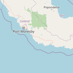
Map view of Varirata National Park

Use this park location map to pinpoint Varirata National Park in Papua New Guinea, understand its exact geographic position, and read its mapped placement within the surrounding landscape more clearly.

Pigeon | © OpenStreetMap contributors

Location context for Varirata National Park

Central Province
Park atlas

Compare regional forest reserves and protected landscapes across the Central Province

Explore Other Parks Near Varirata National Park and Surrounding Protected Areas

Continue browsing national parks and protected areas near Varirata National Park to examine regional forest habitats and elevated terrain. Comparing adjacent conservation zones reveals broader ecological patterns across the surrounding mountainous catchment areas.
National parkMorobe Province
About 253 km away#1 closest

North

McAdam National Park; Geographic Atlas of Protected Highland Forests in Morobe Province

Highland montane forest and rugged ridge landscapes

McAdam National Park preserves a rugged stretch of montane rainforest in Papua New Guinea's Bulolo region. Rising over 1,200 meters, this protected area features steep forested slopes and narrow valleys that define the geography of the Morobe interior. Our atlas provides insights into the park's boundaries and its position within the broader highland ecosystem of the province.

Relief
Mountain
Scope
Terrestrial
Water
Minor water
A wide watercolor illustration showing green hills in the distance, a body of shallow water with pink and green patches, and foreground vegetation including green grasses and pink coral-like structures.
Marine protected areaQueensland
About 294 km away#2 closest

South

Great Barrier Reef Marine Park: Atlas and Geographic Context for Queensland Protected Waters

Exploring the reef system and marine conservation zones in northeastern Australia

The Great Barrier Reef Marine Park stands as an internationally significant marine protected area. By spanning a massive stretch of the Queensland coast, this protected landscape provides a critical framework for marine governance and reef conservation. Users can examine the unique zoning and distribution of coral reef habitats that define this extensive tropical ecosystem.

Area
343,966 km²
Established
1975
Climate
Tropical
Scope
Marine
Wildlife reserveMorobe Province
About 396 km away#3 closest

North

YUS Conservation Area: Mapping the Geographic Range of a Community-Led Wildlife Reserve

Protected tropical forest landscapes in Morobe Province, Papua New Guinea

YUS Conservation Area represents a significant shift in regional conservation, protecting a massive altitudinal gradient on the Huon Peninsula. From coastal coral reef environments to the rugged ridges of the Saruwaged Mountains, the area preserves critical montane habitats and riverine corridors. This dataset provides insight into its unique geography, spanning lowland forests to highland peaks while showcasing a model of land management driven by customary community agreements.

Area
760 km²
Established
2009
Relief
Mountain
Climate
Tropical
Wildlife reserveChimbu Province
About 398 km away#4 closest

Northwest

Crater Mountain Wildlife Management Area: Geography and Protected Land Boundaries in Chimbu Province

Central highland rainforest and cordillera wilderness terrain.

Crater Mountain Wildlife Management Area encompasses a massive tract of undisturbed highland rainforest across the central cordillera of Papua New Guinea. This protected zone demonstrates a unique intersection of tropical montane biodiversity and community-led conservation, providing an essential refuge defined by steep topography, persistent moisture, and continuous forest cover that stretches across the Chimbu Province.

Relief
Highland
Water
Major water bodies
Stylized illustration of a mountain with waterfalls, river, and trees under a bright sky with clouds
Protected areaPapua New Guinea
About 478 km away#5 closest

Northwest

Mount Wilhelm Protected Area: Papua New Guinea's Highest Peak and Alpine Terrain

Mapped geography and protected landscape context for a key Oceania peak.

Mount Wilhelm represents a significant protected area and the highest mountain in Papua New Guinea. Situated within the Bismarck Range, its dramatic granite peak defines a unique alpine environment, transitioning from dense rainforests to high-altitude grasslands. The presence of twin glacial lakes, Piunde and Aunde, adds to its distinctiveness, offering insight into the region's varied natural terrain and its role as a key geographical landmark.

Relief
Mountain
Climate
Alpine
Access
Moderate access
Scope
Terrestrial
National parkQueensland
About 507 km away#6 closest

Southwest

Sir Charles Hardy Group National Park: Queensland National Park Atlas and Geography

Explore its mapped protected landscape and regional context.

Sir Charles Hardy Group National Park serves as a vital protected area within Queensland, Australia. This entry offers an atlas-centric view, detailing the park's mapped boundaries and its contribution to the regional geography. Examine its significance as a national park and understand the natural terrain it encompasses within northeastern Australia.

Area
1.29 km²
Established
1989
IUCN
II
Scope
Terrestrial
National parkAustralia
About 511 km away#7 closest

West

Yamarrinh Wachangan Islands (Denham Group) National Park: Australian Protected Landscape Map and Geography

Mapped boundaries and regional geographic context within Australia.

This detail entry for Yamarrinh Wachangan Islands (Denham Group) National Park provides specific geographic context and atlas information for this Australian national park. It focuses on the protected landscape identity, mapped features, and regional setting, offering a factual foundation for understanding the park's place within Australia's protected areas network. Explore its unique geographic characteristics and its designation as a national park.

National parkQueensland
About 521 km away#8 closest

Southwest

Saunders Islands National Park: National Park Geography and Mapped Protected Landscape in Queensland

Explore the mapped terrain and protected area context.

Saunders Islands National Park represents a significant protected area within the geography of Queensland, Australia. This entry provides detailed atlas-level insights into its specific geographic boundaries and the nature of its protected landscape. Users can understand the park's regional placement and its mapped natural terrain, offering a concrete point for exploring Queensland's diverse protected lands and their unique environmental characteristics.

Area
0.19 km²
Established
1989
IUCN
II
Climate
Tropical

Common questions about visiting, size, designation, and location context for Varirata National Park

Varirata National Park FAQs for park facts, access, geography, and protected area context

Find quick answers about Varirata National Park, including protected-area facts, park geography, trail and visitor context, and how the park fits into its surrounding country and regional landscape.
MoriAtlas Explorer

Continue Your Protected Areas Search Across the Global Atlas

Deepen your exploration by continuing the structured search for national parks and protected areas worldwide. Utilize the comprehensive filtering capabilities to compare different conservation landscapes and refine your understanding of global park geography. Discover more about the distribution and characteristics of protected natural areas.

Global natural geography