
Mori Atlas logo
Natural monumentVávrova skála

Geological outcrops and upland heath habitats within the broader Bohemian-Moravian highlands

Vávrova skála Natural Monument and Protected Landscapes in the Vysočina Region of Czechia

(Vávrova skála (přírodní památka))

Vávrova skála represents a significant natural monument defined by its orthogneiss rock formation and associated summit vegetation. Situated on the slopes of Pohledecký kopec, this protected site preserves a unique fragment of metamorphic bedrock and dry grassland typical of the upland environment in the Kraj Vysočina. By analyzing its geological character, visitors can gain insight into the broader structural history of the Žďárské vrchy mountain range and the central Czech highlands.

rock outcroporthogneissmetamorphic geologydry grasslandbilberry heathupland habitat
Vector illustration of a large rock formation in a canyon with a river flowing through it, pine trees, and a distant waterfall under a stylized sun.

Vávrova skála

Natural monument

Park overview

Structured park overview, official facts, and landscape profile for Vávrova skála

Vávrova skála park facts, protected area profile, and essential visitor context

Review the core facts for Vávrova skála, including designation, size, terrain, visitor scale, habitats, and operating context in one park-focused overview.

About Vávrova skála

Vávrova skála occupies a small but distinctive place in the network of protected natural sites of the Czech Republic. Located in the Vysočina Region, northeast of the village of Pohledec and near Nové Město na Moravě, the monument protects a single rock outcrop and its immediate surroundings, rather than a broad tract of habitat. Its focus is narrow but precise: to safeguard an example of upland metamorphic geology and the thin but specialised plant communities it supports.

The site lies within the Hornosvratecká vrchovina, a highland subunit of the larger Českomoravská vrchovina, and is administratively part of the Žďárské vrchy Protected Landscape Area. The wide Žďárské vrchy context matters: even within this already protected highland region, smaller sites like Vávrova skála are recognised for their individual contributions to habitat diversity, geological exposure, and biodiversity documentation.

The monument is administered by the Agency for Nature Conservation and Landscape Protection of the Czech Republic, through its regional office for the Žďárské vrchy Protected Landscape Area. Its designation reflects the long-standing Czech tradition of using the přírodní památka category to highlight small but scientifically or aesthetically valuable natural features, ranging from rock outcrops and ancient trees to isolated habitats or rare species occurrences.

For visitors, the site represents the kind of quiet, locally meaningful protected place that characterises much of the Vysočina countryside: a small geological landmark integrated into a working cultural landscape of forests, meadows and small villages, with significance that extends well beyond its tiny official footprint.

Quick facts and research context for Vávrova skála

Vávrova skála is a national-level nature monument in Vysočina Region, central Czech Republic. The site lies within the Žďárské vrchy Protected Landscape Area and was designated in 1983. It protects a rock formation measuring roughly 18 by 15.5 metres, with a maximum height of about 10.5 metres. The outcrop is composed of metamorphic rocks including orthogneiss, mica schist, amphibolite and migmatite. Vegetation on the rock and its immediate surroundings includes dry grassland communities and fragments of bilberry-type heath.

Protection and recognition

Terrestrial conservation framework and official recognition records

Vávrova skála Protection Status and Designated Conservation Context

Terrestrial protection records for Vávrova skála outline the documented scope of environmental management and regional conservation frameworks. Official designation details clarify the established status without external recognition sources.

Protection details

Protection scope
Terrestrial
Transboundary protection
No
Park context

Deeper park guide and search-rich context for Vávrova skála

Vávrova skála history, landscape, wildlife, and travel context

Explore Vávrova skála through its history, landscape character, ecosystems, wildlife, conservation priorities, cultural context, and seasonal travel timing in a structured park guide built for atlas discovery and search intent.

Why Vávrova skála stands out

The site is best known for its small but visually distinct orthogneiss rock outcrop, a weathered formation shaped by frost and water during the Quaternary period. The monument protects a representative fragment of summit heath and dry grassland vegetation that survives on these nutrient-poor metamorphic rocks. Beyond its scenic interest, Vávrova skála is valued for what it reveals about the geological character of the surrounding highlands. The Pohledecký kopec area exposes a varied metamorphic sequence including migmatite, orthogneiss, paragneiss, amphibolite and mica schist, making the site a useful reference point for understanding the bedrock geology of the Žďárské vrchy.
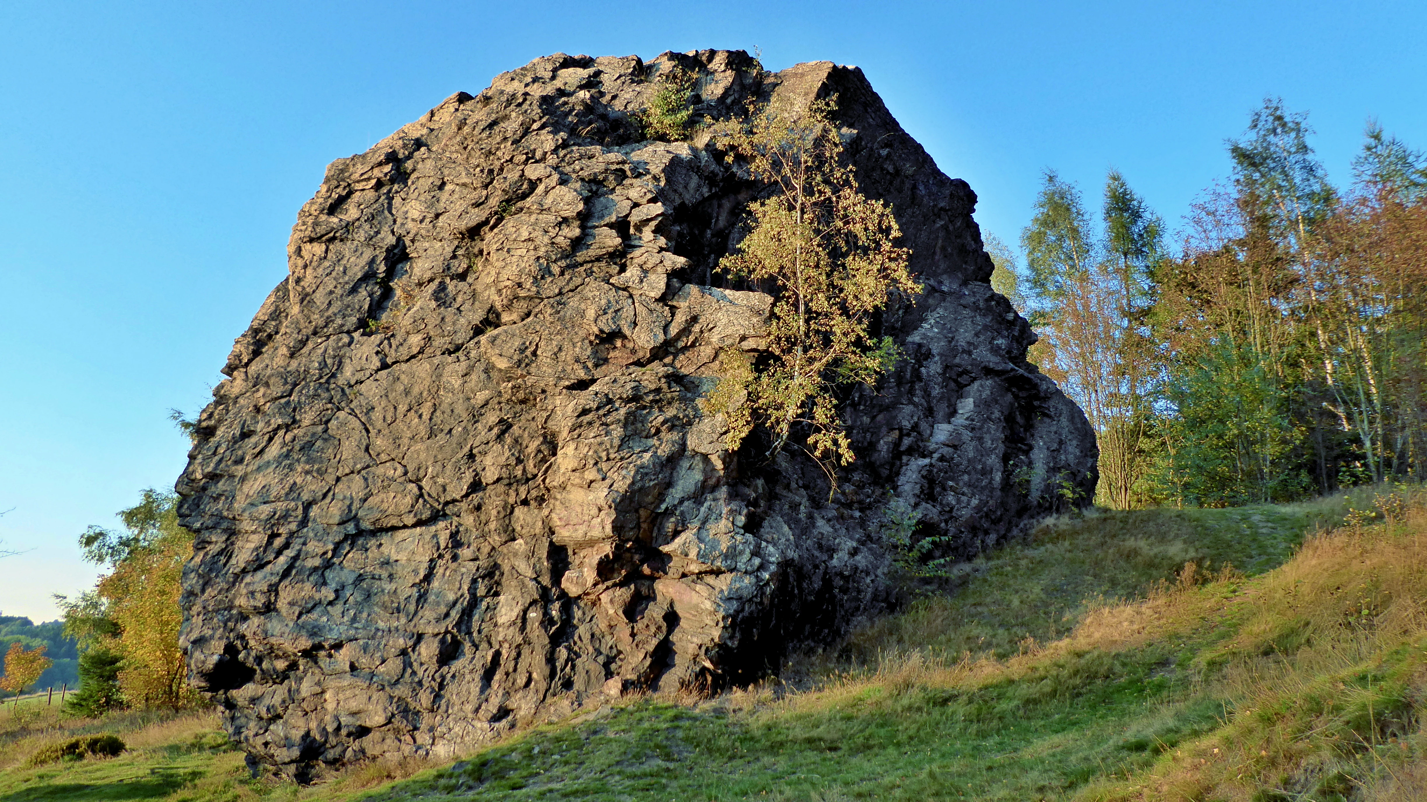
A large, weathered rock outcrop standing prominently on a grassy hillside under a clear blue sky, with trees visible in the background.
The prominent orthogneiss rock formation at the Vávrova skála natural monument.

Vávrova skála history and protected-area timeline

Vávrova skála was officially declared a protected natural monument on 10 March 1983 by the District National Committee in Žďár nad Sázavou, under the former Czechoslovak nature conservation framework. Its designation recognised both the geological value of the metamorphic rock outcrop and the specialised dry grassland and heath vegetation that had developed on and around it.

For more than three decades the site was officially known under the name Na skále. This earlier designation remained in use until 20 November 2017, when the monument was renamed Vávrova skála, aligning the protected site's name with the locally established place name for the rock outcrop itself. The change reflected an effort to associate Czech protected-area names more directly with traditional local toponymy, while preserving the monument's status and boundaries.

The site has continued to be administered within the Žďárské vrchy Protected Landscape Area, an overarching designation that provides additional landscape-level protection to the broader region. Within this wider context, Vávrova skála functions as a small but recognised complementary site, contributing geological and habitat diversity to the protected landscape around it.

Vávrova skála landscape and geographic character

The landscape around Vávrova skála is shaped by the gentle, rolling relief of the Hornosvratecká vrchovina, a highland area forming part of the larger Českomoravská vrchovina. Elevation in the immediate area of the monument sits around 738 to 742 metres, placing it high in the Czech upland context but without dramatic relief. The terrain is dominated by long forested ridges, agricultural meadows, and isolated farmsteads and villages typical of the Vysočina countryside.

The rock outcrop itself breaks this soft topography with a clearly defined, broadly rectangular formation approximately 18 metres long and 15.5 metres wide, rising to about 10.5 metres in height. Its profile, shaped by prolonged weathering, gives the site a visible landmark quality within its immediate surroundings, despite the monument's very small official area of only 0.07 hectares. The outcrop lies on the slope of Pohledecký kopec, where the geological composition shifts across short distances, creating a geologically diverse neighbourhood despite the small scale of the protected feature.

Wider views from the hill include the dispersed patterns of villages and forest edges characteristic of the northern Žďárské vrchy borderlands. Streams draining from the highland feed into the Sázava river system further downstream, linking this small site to the broader hydrological network of central Vysočina.

Vávrova skála ecosystems, habitats, and plant life

Although tiny in geographic extent, Vávrova skála protects a representative example of upland vegetation on nutrient-poor metamorphic bedrock. The rock outcrop and its immediate surroundings support dry grassland communities of grassy swards typical of shallow, acidic substrate, alongside fragments of bilberry-type heath vegetation characteristic of the Czech-Moravian Highlands.

The combination of exposed rock and thin, leached soils limits the development of taller vegetation, favouring low grasses, sedges, mat-forming perennials and dwarf shrubs. These communities are part of the broader network of summit and rock-steppe habitats that recur across the Žďárské vrchy highlands, and they contribute to local biodiversity through their specialised flora and invertebrate assemblages.

Given its position within the Žďárské vrchy Protected Landscape Area, the monument also benefits from broader landscape-scale conservation measures, including habitat continuity with surrounding forest edges, meadows and other rock exposures. This wider matrix helps sustain the small-scale habitat mosaics that define the ecological character of the region.

Vávrova skála wildlife and species highlights

The very small area of Vávrova skála limits its role for larger wildlife, and the site is primarily valued for its geological and botanical character rather than for charismatic fauna. Nonetheless, the dry grassland and heath vegetation on and around the rock outcrop provides microhabitat conditions that support typical Czech upland invertebrate communities, including insects associated with bilberry, grasses and exposed rock surfaces.

The broader forested landscape of the Žďárské vrchy surrounds the monument and supports the usual range of central European forest wildlife, including deer, wild boar, and a variety of smaller mammals and forest birds. The protected landscape area context means that small geological monuments like Vávrova skála function as local habitat islands within a much larger contiguous highland ecosystem.

Vávrova skála conservation status and protection priorities

Vávrova skála contributes to Czech nature conservation by safeguarding a compact example of metamorphic geology and associated dry grassland and heath vegetation within a heavily modified European landscape. Its designation as přírodní památka places it within the third IUCN category of protected area, recognising its scientific, educational and landscape value.

The site fits a broader Czech conservation strategy in which small, narrowly defined monuments complement larger protected landscape areas. While the Žďárské vrchy Protected Landscape Area provides regional-scale protection across the entire highland, monuments like Vávrova skála ensure that particular rock exposures, vegetation types or geological features are not overlooked in land-use planning or public attention.

Long-term conservation of the site depends on the continued protection of its thin vegetation cover and the prevention of excessive disturbance to the rock surface. Because the habitat is small and sensitive to changes in grazing, shrub encroachment or direct rock disturbance, the monument's value lies precisely in maintaining these fine-scale ecological conditions over time.

Vávrova skála cultural meaning and human context

Vávrova skála is embedded in the traditional rural landscape of the Vysočina Region, a highland area in the heart of the Czech Republic historically shaped by small-scale farming, forestry and dispersed settlement. The village of Pohledec, near the monument, illustrates the enduring pattern of Czech-Moravian highland villages, with agricultural land, meadows and forest patches forming the immediate setting.

The protection of such a small rock outcrop reflects the Czech tradition of recognising sites of local cultural and natural significance alongside larger, more spectacular protected areas. Many small monuments in the country carry strong local meaning, often tied to traditional place names, community identity and regional heritage, as is the case with the renaming of this site from Na skále to Vávrova skála in 2017.

Top sights and standout views in Vávrova skála

Vávrova skála offers a focused snapshot of the geological and ecological character of the Czech-Moravian Highlands. Its compact rock outcrop, shaped by Quaternary weathering, is paired with dry grassland and bilberry-type heath vegetation on nutrient-poor metamorphic bedrock.

The monument's location within the broader Žďárské vrchy Protected Landscape Area gives it added value, situating a small but representative upland feature within one of the Czech Republic's most important highland conservation regions.

Best time to visit Vávrova skála

The site can be appreciated across the temperate seasons typical of the Czech-Moravian Highlands. Late spring and early summer are particularly suitable for observing the dry grassland and heath vegetation in active growth, while autumn highlights the autumnal colours of bilberry and surrounding forest edges. Winter visits emphasise the sculptural form of the rock outcrop itself once leaves have fallen and surrounding vegetation recedes.


Monthly climate preview

Track monthly average temperatures and precipitation patterns across the protected landscape

Vávrova skála Climate Normals and Long Term Weather by Month

Representative coordinate records show measured long term temperature swings and monthly precipitation rhythms across the protected terrain. Reviewing the complete twelve month profile provides granular analytical depth beyond this summary preview.
Annual mean7 °C
-4 °C18 °C
Jan-4°
Feb-2°
Mar
Apr
May12°
Jun16°
Jul18°
Aug18°
Sep13°
Oct
Nov
Dec-3°
Warmest month
July

18.5 °C

Coolest month
January

-3.8 °C

Wettest month
July

2.8 mm/day

Driest month
February

1.2 mm/day

Park location guide

Geography guide, regional context, and park location map for Vávrova skála

Vávrova skála park geography, regions, and map view in Czechia

Understand where Vávrova skála sits in Czechia through a broader geographic reading of the surrounding landscape, nearby location context, and its mapped position within the national park landscape.

How Vávrova skála fits into Czechia

Czech Republic is a landlocked Central European country with a population of approximately 10.9 million people. The nation was established as an independent state on January 1, 1993, following the dissolution of Czechoslovakia. Its capital and largest city is Prague, with other major urban centers including Brno, Ostrava, Plzeň, and Liberec.

Wider geography shaping Vávrova skála in Czechia

The Czech Republic is a landlocked country in Central Europe. It is bordered by Germany to the west, Austria to the south, Poland to the northeast, and Slovakia to the southeast. The landscape is predominantly hilly, with the territory covering 78,871 square kilometers.

Map view of Vávrova skála

Use this park location map to pinpoint Vávrova skála in Czechia, understand its exact geographic position, and read its mapped placement within the surrounding landscape more clearly.

Pigeon | © OpenStreetMap contributors

Location context for Vávrova skála

Kraj Vysočina

Visual exploration of orthogneiss rock outcrops and upland habitats in the Vysočina Region.

Vávrova skála Photos and Protected Landscape Scenery

Photographic views reveal the weathered orthogneiss rock formation and surrounding upland vegetation across the protected monument. Visual documentation helps researchers examine the geological character and highland terrain defining the local environment.

A large, weathered rock outcrop standing prominently on a grassy hillside under a clear blue sky, with trees visible in the background.

Park atlas

Compare adjacent highland reserves and connected upland landscapes in the region

Parks Near Vávrova Skála and Surrounding Protected Area Geography

Continue exploring protected areas near Vávrova skála by examining adjacent highland terrain and regional geological features. Comparing these connected landscapes reveals the wider ecological patterns shaping the Czech upland conservation network.
A watercolor painting showing a soft landscape of rolling hills, grassy meadows, and patches of vegetation in a pastel color palette.
Natural monumentKraj Vysočina
About 7.9 km away#1 closest

West

Sklenské louky Natural Monument: Wetland Landscapes in Kraj Vysočina

Highland geography and protected peatland habitats

Sklenské louky functions as a concentrated nature monument within the Kraj Vysočina region, preserving vital moisture-loving vegetation and peat-based ecosystems. The terrain features a characteristic mix of open meadows and spruce groupings, illustrating the diverse landscape character of the Bohemian-Moravian Highlands. This protected area provides a clear view into the region's unique upland hydrological and botanical patterns.

Area
0.063 km²
Established
1985
IUCN
IV
Relief
Upland
A horizontal watercolor painting depicting a soft, scenic view of hills with rocky outcrops in the foreground and a forested landscape in the distance.
Protected areaCzechia
About 8.4 km away#2 closest

North

Malinská skála: Geomorphological Landmark and Viewpoint in the Czech-Moravian Highlands

Protected gneiss rock group and mountain ridge geography

Rising as a striking summit in the Žďárské vrchy, Malinská skála presents a concentrated group of named gneiss towers reaching 20 meters in height. The site functions as a geological monument, preserving classic examples of frost-shattered boulder streams and high-elevation landforms. With its panoramic vantage points, it serves as a central point for mapping the topography of the surrounding Czech upland ridges.

Area
0.058 km²
Established
1987
Relief
Mountain
Climate
Temperate
A soft, horizontal watercolor painting showing a green meadow in the foreground leading to a line of trees and distant rolling hills.
Natural monumentKraj Vysočina
About 13 km away#3 closest

East

Na Ostrážné Natural Monument: Geographic Boundaries and Protected Meadow Landscapes

A vital Natura 2000 site in the Bohemian-Moravian Highlands

The Na Ostrážné natural monument encompasses a compact meadow ecosystem situated on an ecologically expressive slope. This area serves as a critical refuge for rare invertebrate species, maintaining traditional grassland characteristics within the Svratecká hornatina. Its status as both a national monument and a European site makes it a key focus for understanding habitat preservation in the Vysočina Region.

Area
0.014 km²
Established
2015
IUCN
IV
Relief
Upland
A soft watercolor illustration featuring rolling hills in pink and green tones with stylized coniferous trees, set against a white background.
Natural monumentPardubický kraj
About 14 km away#4 closest

North

Rybenské Perničky: Natural Monument and Geological Landmark of the Bohemian-Moravian Highlands

Geological rock outcrops and protected upland terrain in the Pardubice Region

Investigate the geological structure of Rybenské Perničky, a protected natural monument featuring unique orthogneiss outcrops and characteristic bowl-shaped weathering basins. Situated in the Pardubice Region, this site offers a focused look at the crystalline rock formations and undulating plateau terrain of the Bohemian-Moravian Highlands, providing essential geographic context for this noteworthy natural landmark.

Area
0.141 km²
Established
1980
Relief
Upland
Climate
Temperate
A soft watercolor painting of a serene landscape featuring a calm lake surrounded by trees and gentle rolling hills in the background.
Natural monumentKraj Vysočina
About 16 km away#5 closest

West

Rozštípená skála Natural Monument: Geological Mapping of the Vysočina Gneiss Outcrops

Protected rocky terrain in the Bohemian-Moravian Highlands

Rozštípená skála features a striking gneiss cliff formation split by long weathered fissures. Located in the Vysočina Region, this natural monument provides a focal point for understanding the geological patterns and river valley landscapes that define the mid-altitude terrain of the Czech Republic.

Area
0.008 km²
Established
1974
IUCN
III
Relief
Upland
Nature reserveKraj Vysočina
About 17 km away#6 closest

East

Pyšolec Nature Reserve: Protected Forest Geography and Mapped Terrain in Kraj Vysočina

Biodiverse woodland and historic castle ruin protected area

Pyšolec is a significant nature reserve characterized by mature broadleaf forests and steep, rocky terrain in the Czech Vysočina Region. The site provides a critical habitat for specialized invertebrates and rare species within its unique forest-castle mosaic, mapped here for geographic context and ecological study.

Area
0.342 km²
Established
2021
IUCN
IV
Relief
Upland
A soft watercolor illustration of a landscape with rolling hills, a meandering stream, and wooded areas against a pale sky.
Natural monumentVysočina Region
About 19 km away#7 closest

Southwest

Rasuveň Natural Monument: Protected Forest Terrain in the Czech Vysočina Region

Mapping upland woodland and fir-beech conservation areas

Rasuveň protects a meaningful remnant of fir-beech forest in the Czech-Moravian Highlands. This natural monument, situated in the Vysočina Region, provides a quiet example of mature upland woodland conservation. Its geographic profile is defined by rolling ridges and crystalline bedrock, offering a dedicated space for observing natural forest structures within an increasingly managed agricultural landscape.

Area
0.207 km²
Established
1989
IUCN
IV
Relief
Upland
Watercolor painting of a rolling countryside scene featuring green hills, forest edges, and muted pastel tones on a white background.
Protected landscapeVysočina Region
About 21 km away#8 closest

Southwest

Přírodní park Bohdalovsko: Protected Landscape and Wetland Geography in the Vysočina Region

Highland terrain, fishpond mosaics, and protected natural corridors.

Located in the Czech Republic, Přírodní park Bohdalovsko serves as a primary example of a cultural highland landscape. The area features a remarkable concentration of ponds and peatland pockets that anchor local biodiversity, including rare aquatic species and amphibian strongholds. Its geography is characterized by rolling uplands and varied forest-field mosaics that remain integral to the regional conservation framework of the Bohemian-Moravian Highlands.

Area
60.8 km²
Established
2001
Relief
Upland
Climate
Temperate

Common questions about visiting, size, designation, and location context for Vávrova skála

Vávrova skála FAQs for park facts, access, geography, and protected area context

Find quick answers about Vávrova skála, including protected-area facts, park geography, trail and visitor context, and how the park fits into its surrounding country and regional landscape.
MoriAtlas Explorer

Continue Your Protected Areas Search Across the Global Atlas

Deepen your exploration by continuing the structured search for national parks and protected areas worldwide. Utilize the comprehensive filtering capabilities to compare different conservation landscapes and refine your understanding of global park geography. Discover more about the distribution and characteristics of protected natural areas.

Global natural geography