

Mori Atlas logo
Natural monumentVe Farářském

Mapped meadow and pond margin habitats defining South Bohemian regional geography

Ve Farářském Natural Monument: Exploring Wetland Protected Landscapes in Jihočeský kraj

Ve Farářském stands as a protected natural monument within the Jihočeský kraj region of the Czech Republic. This site preserves a compact but ecologically rich wetland system along the western shore of the Farářský fishpond, where damp mesotrophic meadows transition into sedge and willow-fringed marshland. The area offers a detailed look at the small-scale mosaic of waterlogged habitats characteristic of the wider Tábo district landscape.

natural monumentwetlandmesotrophic meadowfishpondpond marginsedge marsh
A flat vector illustration of a calm pond with lily pads in the foreground, backed by green trees, a grassy meadow, and a forest under a soft, cloudy sky.

Ve Farářském

Natural monument

Park overview

Structured park overview, official facts, and landscape profile for Ve Farářském

Ve Farářském park facts, protected area profile, and essential visitor context

Review the core facts for Ve Farářském, including designation, size, terrain, visitor scale, habitats, and operating context in one park-focused overview.

About Ve Farářském

Ve Farářském is a small but ecologically focused natural monument in the South Bohemian Region of the Czech Republic, lying in the countryside between the villages of Drahov, Veselí nad Lužnicí, and Zlukov in the Tábo district. Although modest in size at roughly 3.76 hectares, the site captures one of the defining ecological transitions of the traditional South Bohemian fishpond landscape, from open water through fringing marsh to permanently damp meadow.

The protected area was first established in 1988 under the name Farářský rybník, centered on Farářský rybník, a small pond whose surface and immediate margins defined the original site. The original rationale focused on the presence of white water lily, a classic indicator of nutrient-poor, relatively undisturbed pond ecosystems. Over time, ecological conditions shifted, and the white water lily population was no longer recorded on the site. In October 2025, the territory was re-declared under the name Ve Farářském, with the conservation subject reoriented toward the western bank.

What makes Ve Farářském distinctive is its concentration of mesotrophic, seasonally or permanently waterlogged meadows. Mesotrophic habitats occupy a middle ground between nutrient-rich and nutrient-poor wetlands; they support a characteristic mix of plant species that often disappear when land use intensifies or hydrology changes. At Ve Farářském, the meadow communities pass through visible successional and hydrological gradients: from sedge (Carex) stands to rush (Juncus) formations, and finally into the littoral fringe where shrubby willows (Salix) take hold along the pond's edge.

The site's formal conservation subject also names three vascular plants of particular interest: marsh pennywort, tufted loosestrife, and, historically, white water lily. Whether or not the lily still survives on site, its inclusion underscores the continuity of interest in the pond's aquatic flora alongside the bank vegetation. The compact mosaic of meadow, marsh, and willow habitats, all on a few hectares, makes Ve Farářském a useful representative of the South Bohemian wetland pattern.

Quick facts and research context for Ve Farářském

Ve Farářském is a Czech natural monument (přírodní památka, IUCN category III) located in the South Bohemian Region, Tábo district, near the villages of Drahov, Veselí nad Lužnicí, and Zlukov. The protected area sits at an elevation of about 430 meters and covers approximately 3.76 hectares along the western shore of Farářský rybník.

The site was first designated on 21 January 1988 under the name Farářský rybník and was re-proclaimed as Ve Farářském in October 2025 with a revised conservation subject. The current protection targets mesotrophic waterlogged meadows, associated sedge and rush vegetation, and littoral willow stands, with three plant species named in the conservation subject.

Protection and recognition

Terrestrial conservation metrics, designation timeline, and recognition records

Ve Farářském Protection Status and Documented Conservation History

Documented protection status and designation history for Ve Farářském outline the established terrestrial framework governing the natural area. Official records detail the 2025 establishment year and management scope without external conservation rankings.

Protection details

Protection scope
Terrestrial
Designated year
2025
Transboundary protection
No
Park context

Deeper park guide and search-rich context for Ve Farářském

Ve Farářském history, landscape, wildlife, and travel context

Explore Ve Farářském through its history, landscape character, ecosystems, wildlife, conservation priorities, cultural context, and seasonal travel timing in a structured park guide built for atlas discovery and search intent.

Why Ve Farářském stands out

Ve Farářském is best known for its mesotrophic, waterlogged meadow complex on the western bank of Farářský rybník, where damp grassland grades into sedge stands, rushes, and finally shrubby willow fringes at the pond edge. It is also historically notable as a former locality for white water lily, the water plant that anchored the site's original 1988 protection but which has not been recorded on site for more than ten years. In a broader sense, the site exemplifies the small-scale, pond-margin wetland patches typical of the South Bohemian countryside, where modest protected areas safeguard ecological transitions between open water, marsh, and meadow.
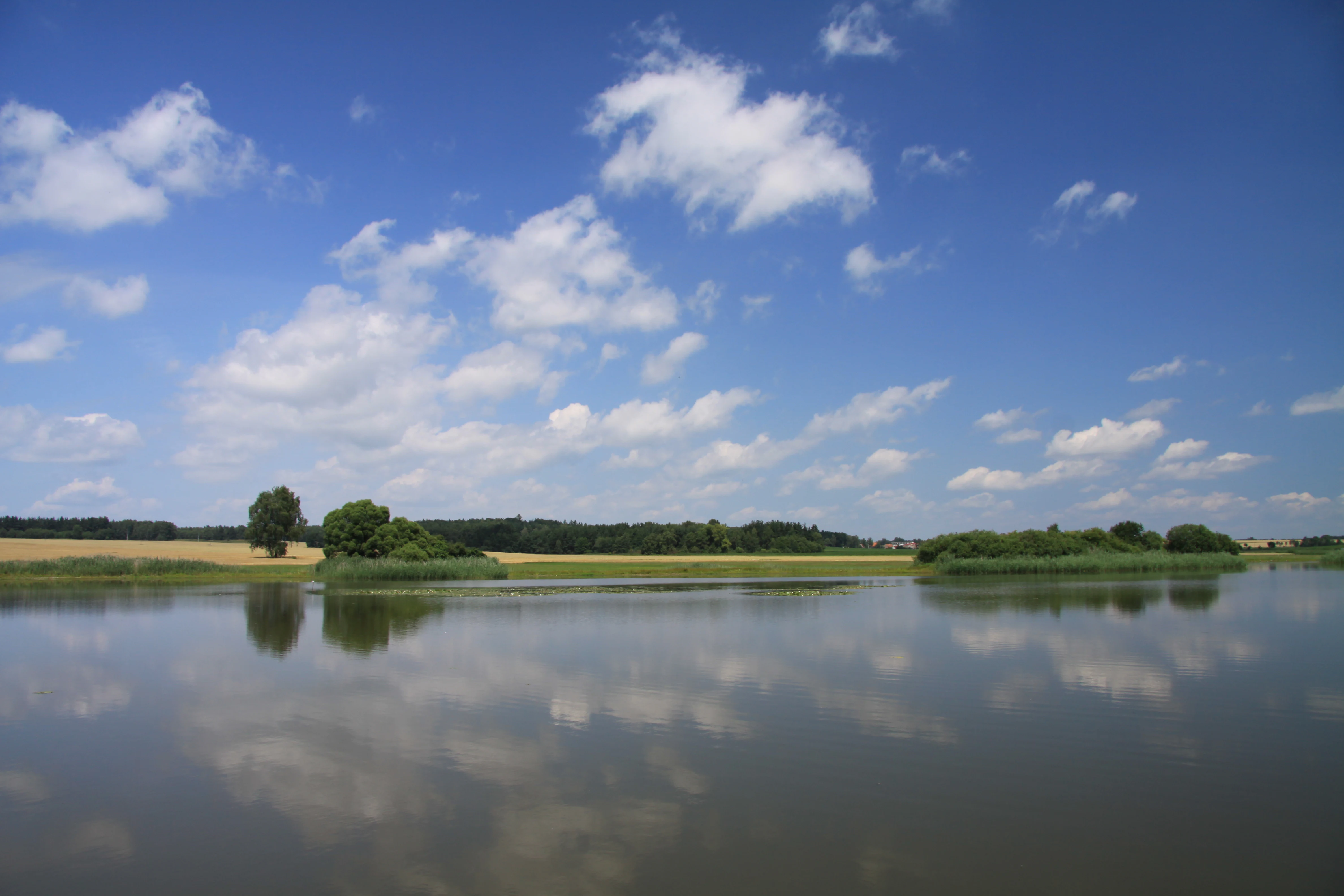
A calm, still pond reflecting a bright blue sky with white clouds, surrounded by grassy banks and distant tree lines in a rural landscape.
A summer view of the water body at the Ve Farářském natural monument.

Ve Farářském history and protected-area timeline

Ve Farářském has a short but distinctive administrative history. The site was originally proclaimed on 21 January 1988 under the name Farářský rybník, as a natural monument in what is now the South Bohemian Region. At that time, the pond itself was the core of the protected status, because the water lily known as white water lily was documented there, and the pond's extent broadly defined the protected area's boundary.

In the decades that followed, the white water lily population was not confirmed on the site for more than ten years, reflecting changes in the pond's ecology or in the lily's local status. To reflect this shift and refocus protection on habitat types that remained biologically significant, the territory was re-declared on 16 October 2025 under the new name Ve Farářském.

The 2025 redesignation moved the protected zone onto the western bank of Farářský rybník and changed the conservation subject from a single aquatic plant species to a broader set of mesotrophic wetland habitats. This redefinition preserves continuity for the original locality while aligning the site's legal protection with the vegetation that is actually present and ecologically meaningful today.

Ve Farářském landscape and geographic character

The landscape of Ve Farářském is defined by a single dominant feature: Farářský rybník, a small fishpond set in the flat to gently rolling South Bohemian countryside. The protected strip runs along the western shore of the pond, occupying the transition between open water and the surrounding agricultural land.

At ground level, the bank's vegetation forms a clear gradient. Inland from the water, damp mesotrophic meadows hold the gentle slope. Moving toward the pond, sedge-dominated stands appear, followed by rush formations in the wettest positions. At the pond margin, low shrubby willows fringe the water, creating a soft, water-bound edge that contrasts with the more open meadow further up the bank.

The wider setting is characteristically South Bohemian: a mosaic of fishponds, meadows, fields, small villages, and woodland patches typical of the Tábo district. The protected area sits at approximately 430 meters elevation, and its scale is small, but it captures the specific landform pattern where a pond margin becomes a wetland meadow, a configuration that recurs across this part of the Czech Republic.

Ve Farářském ecosystems, habitats, and plant life

The vegetation at Ve Farářském is the heart of the site's ecological identity. The protected meadow complex is described as mesotrophic and waterlogged, indicating soils that are consistently wet but not severely nutrient-enriched, a condition that supports a distinctive plant community often lost to drainage and intensification.

Three structural vegetation layers are recognized. Mesotrophic meadows form the inland and largest component. Sedge and rush communities occupy transitional, wetter ground, with Carex species and bulrush (Sítina) playing important roles. At the pond edge, littoral stands dominated by shrubby willows replace the herbaceous vegetation, creating a low woody fringe.

Three species are explicitly named in the conservation subject. Marsh pennywort (Hydrocotyle vulgaris) and tufted loosestrife (Lysimachia thyrsiflora) are characteristic mesotrophic-wetland plants whose continued presence anchors the site's value. White water lily (Nymphaea alba) is also named, although it has not been confirmed on the site for more than ten years, indicating ongoing monitoring interest in the pond's aquatic flora alongside the bank meadows.

Ve Farářském wildlife and species highlights

The available source material for Ve Farářském does not provide detailed wildlife information beyond the botanical focus of the site. No bird, mammal, fish, or invertebrate species are described, and no specific faunal conservation targets are named. The site's ecological story is primarily told through plant communities and habitat types rather than animal life.

This reflects a broader pattern for very small pond-margin natural monuments in the Czech Republic, where the formal protection subject is usually centered on vegetation rather than fauna, even though such habitats often support amphibians, dragonflies, and waterbirds as part of the wider landscape. For Ve Farářském, a standalone wildlife section cannot be supported without speculation, and so is not developed here.

Ve Farářském conservation status and protection priorities

Ve Farářském is protected as a přírodní památka, a natural monument under Czech nature conservation law, corresponding to IUCN category III. The designation emphasizes the protection of specific natural features, here particular plant habitats and species, rather than full ecosystem-scale protection.

Two conservation phases are visible in the site's history. From 1988, protection focused on the white water lily population in Farářský rybník. After that population was no longer confirmed, the 2025 redesignation shifted the protected territory from the pond itself to the western bank and broadened the conservation subject to cover mesotrophic waterlogged meadows, their transition through sedge and rush communities, and the littoral willow fringe.

The current legal protection explicitly hinges on three plant elements: the mesotrophic meadow complex, marsh pennywort, and tufted loosestrife, with white water lily retained as part of the conservation subject despite its absence in recent years. This combination signals a conservation approach that protects both habitat structure and indicator species, anchoring the site's long-term significance on the persistence of these particular wetland communities in the South Bohemian landscape.

Top sights and standout views in Ve Farářském

The standout features of Ve Farářském are concentrated on a few hectares of pond-margin habitat. The site's key highlights include the mesotrophic waterlogged meadows on the western bank, the visible gradient from sedge and rush stands to shrubby willow fringe, and the named plant species of conservation interest: marsh pennywort, tufted loosestrife, and historically white water lily.

Equally notable is the site's recent administrative transformation: a 1988 fishpond-centered protection was reworked in 2025 into a bank-focused designation, making Ve Farářském a small but instructive example of how Czech natural monuments evolve to track real ecological change on the ground.

Best time to visit Ve Farářském

Ve Farářském is a small natural monument whose appeal lies in observing a specific habitat, the mesotrophic wet meadow and pond margin, rather than in dramatic seasonal scenery. Late spring and summer are generally the most rewarding periods for visiting similar South Bohemian wetland sites, when meadow and marsh plants are in active growth and identification of characteristic species is easiest.

Visiting during drier spells can make wet-meadow terrain easier to walk on, while higher water levels in and around Farářský rybník may make the bank vegetation more vivid but potentially harder to approach. Because the site is small and ecologically focused, it suits short, observational visits rather than extended excursions; the quality of the experience depends primarily on the state of the meadow rather than on any specific calendar window.


Monthly climate preview

Long-term monthly temperature and precipitation patterns for Ve Farářském

Ve Farářském Climate Normals and Annual Temperature Rhythm

Representative coordinate measurements reveal the annual temperature and precipitation rhythm across Ve Farářském based on historical climate normals. Detailed monthly breakdowns provide complete baseline data for tracking long-term environmental trends across the protected area.
Annual mean8 °C
-3 °C19 °C
Jan-3°
Feb-2°
Mar
Apr
May13°
Jun17°
Jul19°
Aug19°
Sep13°
Oct
Nov
Dec-2°
Warmest month
July

18.7 °C

Coolest month
January

-3 °C

Wettest month
July

2.9 mm/day

Driest month
February

1.1 mm/day

Park location guide

Geography guide, regional context, and park location map for Ve Farářském

Ve Farářském park geography, regions, and map view in Czechia

Understand where Ve Farářském sits in Czechia through a broader geographic reading of the surrounding landscape, nearby location context, and its mapped position within the national park landscape.

How Ve Farářském fits into Czechia

Czech Republic is a landlocked Central European country with a population of approximately 10.9 million people. The nation was established as an independent state on January 1, 1993, following the dissolution of Czechoslovakia. Its capital and largest city is Prague, with other major urban centers including Brno, Ostrava, Plzeň, and Liberec.

Wider geography shaping Ve Farářském in Czechia

The Czech Republic is a landlocked country in Central Europe. It is bordered by Germany to the west, Austria to the south, Poland to the northeast, and Slovakia to the southeast. The landscape is predominantly hilly, with the territory covering 78,871 square kilometers.

Map view of Ve Farářském

Use this park location map to pinpoint Ve Farářském in Czechia, understand its exact geographic position, and read its mapped placement within the surrounding landscape more clearly.

Pigeon | © OpenStreetMap contributors

Location context for Ve Farářském

Jihočeský kraj

Explore visual records of wetland habitats, sedge marshes, and pond-margin terrain.

Ve Farářském Photos and Landscape Scenery: Visual Protected Area Guide

Visual records capture the distinct wetland habitats, sedge marshes, and willow fringes defining the protected landscape around Farářský rybník. Photographic documentation reveals the ecological transitions between open water and waterlogged meadows across the South Bohemian countryside.

A calm, still pond reflecting a bright blue sky with white clouds, surrounded by grassy banks and distant tree lines in a rural landscape.

Park atlas

Compare regional wetland reserves and connected South Bohemian landscapes

Parks Near Ve Farářském And Surrounding Protected Areas

Explore other protected areas near Ve Farářském to discover similar wetland habitats and pond-margin ecosystems across the South Bohemian countryside. Comparing adjacent reserves reveals broader regional patterns in local waterlogged meadows, sedge marshes, and shallow fishpond margins.
A watercolor painting showing a soft, panoramic view of a wetland with sparse trees, low bushes, and distant rolling hills in pale green and pink tones.
Nature reserveJihočeský kraj
About 5 km away#1 closest

Southwest

Rašeliniště Hovízna: Protected Peatland and Regional Geography in Jihočeský kraj

Ecological sanctuary and spring-fed wetland landscape.

Rašeliniště Hovízna is a notable nature reserve in the Czech Republic, renowned for its distinctive spring-fed peat formation. Situated near the historic Zlatá stoka canal and the Třeboň Basin, this protected area preserves rare bog habitats and essential groundwater-driven ecosystems within the undulating lowlands of Jihočeský kraj.

Area
0.071 km²
Established
1995
IUCN
IV
Relief
Lowland
A horizontal watercolor painting showing a pale landscape with faint rolling hills in the background and soft green tree silhouettes in the foreground.
Natural monumentJihočeský kraj
About 12 km away#2 closest

South

Slepičí vršek Natural Monument: Exploring Inland Sand Dune Geography in the Třeboň Basin

Protected psammophilous landscape in Jihočeský kraj

Slepičí vršek represents a distinct eolian feature within the broader Třeboňsko landscape, characterized by its dry, undulating sandy soil and rare vegetation. This protected monument offers a clear case study for understanding inland dune development and the specialized biodiversity of relict habitats within the South Bohemian Region.

Area
0.019 km²
Established
1955
IUCN
III
Relief
Lowland
Nature reserveCzechia
About 12 km away#3 closest

Northwest

Veselská blata Nature Reserve: Basin Peatland and Wetland Geography in South Bohemia

A core protected mire site within the Czechia regional landscape.

Located in the Tábor District, Veselská blata protects rare transitional peatland ecosystems and bog pine woodlands. This reserve offers a clear view of basin mire hydrology, featuring a diverse mosaic of flooded pools and waterlogged meadows that remain vital to regional ecological conservation efforts in South Bohemia.

Area
4.538 km²
Established
2011
Relief
Lowland
Climate
Temperate
Natural monumentJihočeský kraj
About 28 km away#4 closest

Southwest

Vrbenská tůň Natural Monument: Wetland Geography and Protected Landscape Analysis

A significant oxbow wetland fragment in the South Bohemian region.

Vrbenská tůň functions as a protected natural monument focused on the conservation of lowland pond ecosystems. Located within the Jihočeský kraj, this area offers a window into the hydrology of the České Budějovice Basin, supporting specialized amphibian populations and aquatic flora within its restored basin and surrounding buffer zones.

Area
0.009 km²
Established
1974
IUCN
III
Relief
Lowland
Natural monumentJihočeský kraj
About 29 km away#5 closest

East

Vosecký rybník Natural Monument: Protected Wetland Geography in Jihočeský kraj

Rare drawdown-bottom flora and aquatic ecosystems

Located in the Javořická vrchovina highlands, Vosecký rybník is a protected natural monument known for its specialized pond-bottom vegetation. The site serves as a vital ecological corridor for threatened species within the broader mosaic of historic Bohemian fishpond landscapes.

Area
0.071 km²
Established
2022
IUCN
III
Relief
Upland
A soft watercolor illustration of a pond landscape with grassy banks, reeds, and soft green vegetation in the background.
Nature reserveJihočeský kraj
About 33 km away#6 closest

Southwest

Rybník Motovidlo Nature Reserve: Geographic Overview and Protected Area Profile

A critical aquatic landscape within the Jihočeský kraj region

Rybník Motovidlo is a specialized nature reserve in the Czech Republic, recognized for its role in conserving endangered aquatic vegetation and providing a refuge for diverse amphibian fauna. Its geographic position within the České Budějovice Basin links it to the broader network of South Bohemian ponds. The site serves as a vital case study for the integration of traditional pond management with modern biodiversity protection in a wetland-focused environmental context.

Area
0.116 km²
Established
2022
IUCN
III
Relief
Lowland
A watercolor painting of a river landscape with rolling hills in the background and soft vegetation along the banks.
Natural monumentJihočeský kraj
About 35 km away#7 closest

Northwest

Smutný Natural Monument: Geographic Profile and Protected Fluvial Landscape in Jihočeský Kraj

A naturally meandering lowland stream corridor in the Czech Republic

The Smutný Natural Monument protects a significant 2.5 kilometer reach of the Smutná River, characterized by its remarkably intact fluvial morphology. Unlike typical agricultural watercourses in the region, this corridor features natural riffle-pool sequences and sediment deposition patterns along a gentle Bohemian valley. The protected site serves as a vital ecological anchor for riparian vegetation and wetland flora, demonstrating how undisturbed stream dynamics shape local terrain and provide persistent freshwater habitats.

Area
0.044 km²
Established
1985
IUCN
III
Relief
Lowland
Natural monumentJihočeský kraj
About 37 km away#8 closest

Southwest

Velký Karasín Natural Monument: Mapped Wetland Geography and Protected Landscape Context

A protected wetland sanctuary in the South Bohemian Region of the Czech Republic.

Discover the geographic character of Velký Karasín, a compact natural monument featuring an eutrophic fishpond and fringing reed beds. This protected area serves as an essential site for waterbirds and endangered dragonfly populations, offering a clear example of wetland preservation amidst the gently undulating terrain of the České Budějovice District.

Area
0.108 km²
Established
1991
IUCN
IV
Relief
Lowland

Common questions about visiting, size, designation, and location context for Ve Farářském

Ve Farářském FAQs for park facts, access, geography, and protected area context

Find quick answers about Ve Farářském, including protected-area facts, park geography, trail and visitor context, and how the park fits into its surrounding country and regional landscape.
MoriAtlas Explorer

Continue Your Protected Areas Search Across the Global Atlas

Deepen your exploration by continuing the structured search for national parks and protected areas worldwide. Utilize the comprehensive filtering capabilities to compare different conservation landscapes and refine your understanding of global park geography. Discover more about the distribution and characteristics of protected natural areas.

Global natural geography