
Mori Atlas logo
Nature reserveVelký Hodonický rybník

Examining the ecological boundaries and aquatic habitat of a protected Bohemian fishpond

Velký Hodonický rybník Nature Reserve and Mapped Protected Wetland Landscape in South Bohemia

(Velký Hodonický rybník (přírodní památka))

Velký Hodonický rybník represents a vital nature reserve situated within the gently rolling Novohradské podhůří highlands of the South Bohemian region. This 2.71 hectare protected area functions as an essential refuge for the white water lily and diverse dragonfly communities, offering a distinct example of traditional water management within a modern conservation framework. The site serves as a mapped anchor for biodiversity, illustrating the resilience of mesotrophic aquatic habitats across the broader Czech landscape.

fishpondnatural monumentwetlandaquatic plantswhite water lilydragonflies
A flat-style vector illustration showing a small lake or pond surrounded by a dense green forest, with gentle rolling hills and a pastel sunset in the background.

Velký Hodonický rybník

Nature reserve

Park overview

Structured park overview, official facts, and landscape profile for Velký Hodonický rybník

Velký Hodonický rybník park facts, protected area profile, and essential visitor context

Review the core facts for Velký Hodonický rybník, including designation, size, terrain, visitor scale, habitats, and operating context in one park-focused overview.

About Velký Hodonický rybník

Velký Hodonický rybník is a recently declared natural monument centered on a small fishpond in the South Bohemian Region of the Czech Republic. The protected area lies in the Novohradské podhůří highlands, within the Soběnovská vrchovina geomorphological subunit and the Malontská sníženina area, in a gently rolling landscape close to the Austrian border. Although the site covers only about 2.71 hectares, it has gained formal protection because the pond harbors a population of the strongly threatened white water lily and supports a noteworthy assemblage of wetland plants, dragonflies, and amphibians.

The pond is part of the centuries old Bohemian tradition of managed fishponds. Its usable water surface of around 2.2 hectares is used for extensive to semi-intensive rearing of common carp, with tench sometimes added to the stock. The pond itself is shallow, averaging about half a meter deep and reaching a maximum of around 1.5 meters, and it sits in the spring area of a small watercourse that feeds into the Hodonický potok. Geologically, the bedrock consists of Holocene sediments with a shallow peat layer overlying cordierite-bearing biotite paragneiss, while the surrounding soils are dominated by pseudogley cambisols grading into gleys and organosols typical of wetland margins.

Ecologically, the fishpond represents a mesotrophic water body of the cooler Bohemian uplands, a relatively uncommon habitat type in the modern Czech landscape. Its botanical interest lies in the surviving population of white water lily together with marsh willowherb, cowbane, marsh cinquefoil, lesser bladderwort, dense-flowered mullein, and marsh speedwell. Its faunal interest is concentrated among dragonflies and amphibians, which use the pond as breeding habitat. The overlap of the protected area with a same-named European Site of Community Importance confirms the site's relevance within the Natura 2000 network and gives this small pond an importance well beyond its modest size.

Quick facts and research context for Velký Hodonický rybník

Velký Hodonický rybník is a Czech natural monument (přírodní památka), a national IUCN Category III designation, in the Novohradské podhůří foothills of South Bohemia. It lies at about 630 to 631 meters above sea level and covers 2.71 hectares within the cadastral area of Hodonice u Malont, municipality of Malonty, Český Krumlov district.

The pond itself is roughly 2.78 hectares in area with about 2.2 hectares of usable water surface, an average depth of around half a meter, and a maximum depth of about 1.5 meters. The protected area coincides with a European Site of Community Importance, and the site was formally declared on 26 October 2023 by the Regional Authority of the South Bohemian Region.

Protection and recognition

Examining documented designation records and international recognition sources for Velký Hodonický rybník

Velký Hodonický rybník Protection Status and Natura 2000 Recognition

Velký Hodonický rybník holds documented conservation status supported by official Natura 2000 recognition records. Structured protection metrics outline the designated boundaries and administrative context for this protected natural area.
Park context

Deeper park guide and search-rich context for Velký Hodonický rybník

Velký Hodonický rybník history, landscape, wildlife, and travel context

Explore Velký Hodonický rybník through its history, landscape character, ecosystems, wildlife, conservation priorities, cultural context, and seasonal travel timing in a structured park guide built for atlas discovery and search intent.

Why Velký Hodonický rybník stands out

Velký Hodonický rybník is best known for its population of the white water lily (Nymphaea candida), a strongly threatened aquatic species whose persistence is the principal reason for the pond's protected status. The site also stands out for its rich community of dragonflies, including several species listed on IUCN red lists, and for the way it combines traditional fishpond management with conservation of mesotrophic wetland vegetation. Its protected footprint is small but ecologically focused, and the overlap with a European Site of Community Importance gives the pond a recognized role within the broader Natura 2000 network in the South Bohemian countryside.
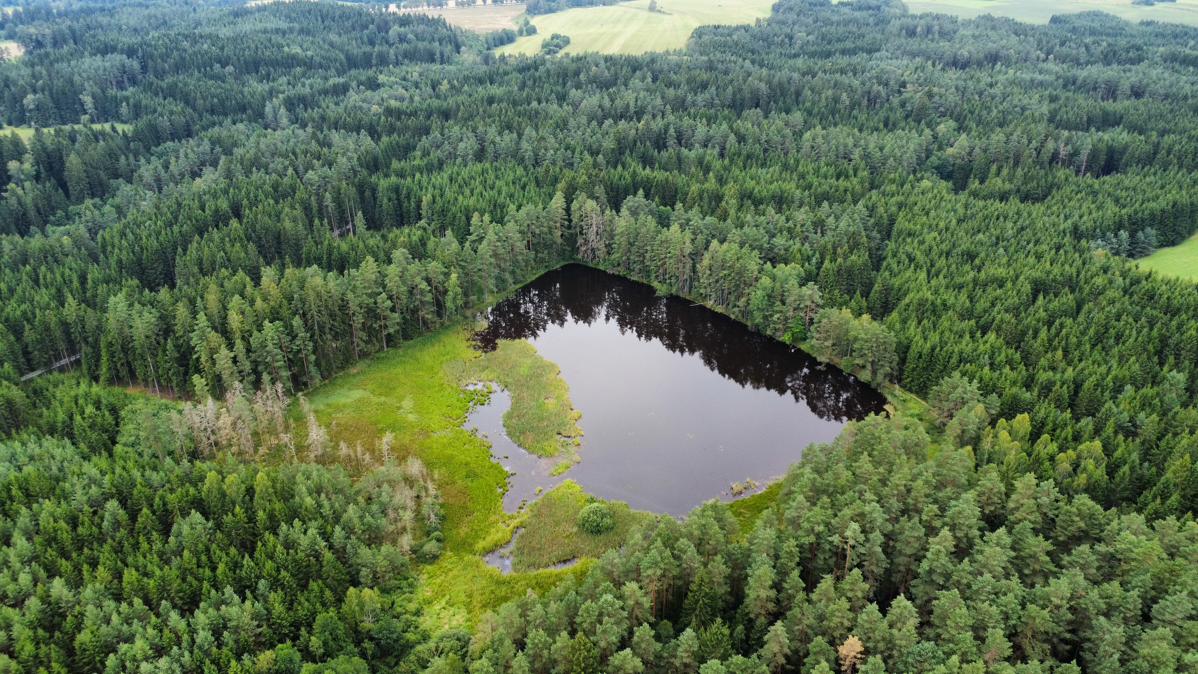
An aerial view of a dark, irregularly shaped pond surrounded by dense coniferous forest and green wetlands.
Aerial view of Velký Hodonický rybník, highlighting its location within a dense forest.

Velký Hodonický rybník history and protected-area timeline

The history of Velký Hodonický rybník is closely tied to the management challenges of a small upland fishpond. In the twentieth century, poorly designed drainage works upstream of the pond repeatedly deprived it of water, allowing its margins and shallows to be colonized by reed sweet-grass (Glyceria maxima). As a result, large parts of the pond lost their open-water character and the original aquatic vegetation was suppressed.

A turning point came in the 1990s, when a new inflow was redirected into the pond. Although this did not guarantee full refilling, it improved water levels enough for the reed sweet-grass to retreat. During repairs to the outlet in 1997, the exposed pond bottom germinated a large cohort of white water lily seedlings. When water levels rose again in subsequent years, the water lily population declined sharply and almost disappeared. By the time the site was declared a protected natural monument, the population had stabilized at roughly one hundred individuals, and the fishpond was being managed by the company Rybářství Nové Hrady.

The protected area was formally declared on 26 October 2023 by the Regional Authority of the South Bohemian Region, in the category of natural monument, marking the culmination of decades of hydrological instability and ecological recovery at the pond.

Velký Hodonický rybník landscape and geographic character

The protected area sits in a gently rolling spring area of a small right-bank tributary of the Hodonický potok, within the broader Novohradské podhůří highlands. The terrain is only mildly undulating, and the pond occupies a shallow depression in the upper part of this small catchment at an elevation of roughly 630 to 631 meters above sea level. The visual character of the site is shaped more by water and wetland margins than by dramatic relief, with the small open water surface set against wooded slopes and agricultural land typical of the South Bohemian foothills.

Geologically, the pond basin overlies Holocene sediments with a thin peat layer, beneath which lies cordierite-bearing biotite paragneiss of the Moldanubian basement. The surrounding soils reflect the wet conditions: pseudogley cambisols dominate the slopes, while gleys and organosols appear closer to the water. The combination of shallow peat, fine sediments, and a shallow water column creates the soft, waterlogged setting that defines both the scenery and the ecology of the site.

Velký Hodonický rybník ecosystems, habitats, and plant life

Ecologically, Velký Hodonický rybník is a mesotrophic water body typical of the cooler upland regions of Bohemia, a habitat type that has become relatively scarce in the modern Czech landscape. The pond supports a layered aquatic and wetland vegetation, with the protected white water lily at its center and a wider cast of wetland plants filling the marginal zones.

Beyond its flora, the pond serves as a key breeding and refuge habitat for amphibians and dragonflies adapted to nutrient-poor but oxygen-rich standing water. Its condition fluctuates with water levels, which directly affects the balance between reed sweet-grass, open water, and submerged vegetation. The simultaneous ecological pressures of traditional fish culture and conservation management create a delicate equilibrium that defines the natural character of the site.

Velký Hodonický rybník wildlife and species highlights

The wildlife interest of Velký Hodonický rybník centers on odonates and amphibians that use the shallow pond and its margins as breeding habitat. Among dragonflies, the site hosts several species listed on IUCN red lists, notably the yellow-spotted whiteface (Leucorrhinia pectoralis), the common hawker (Aeshna juncea), the scarce emerald damselfly (Lestes dryas), and the small emerald damselfly (Lestes virens).

The pond also supports a diverse amphibian community. Smooth newt and great crested newt have been caught at the site, along with common frog, pool frog, and agile frog. Calling males have confirmed the presence of the pool frog species complex and the European tree frog. Together, these species underline the role of the fishpond as a small but ecologically rich refuge for wetland-dependent fauna in the Novohradské podhůří.

Velký Hodonický rybník conservation status and protection priorities

The principal conservation value of Velký Hodonický rybník lies in its surviving population of the white water lily, a strongly threatened species whose presence is the formal subject of protection. The protected vegetation community, classed as mesotrophic water vegetation of cooler regions with white water lily, covers about 18 percent of the protected area and forms the legal core of the site.

In addition to the water lily, conservation targets include several odonate and amphibian species, including yellow-spotted whiteface, smooth newt, great crested newt, agile frog, pool frog, and European tree frog, together with other typical wetland plants. The site's full overlap with a European Site of Community Importance places it within the Natura 2000 network and gives it additional international recognition. Management aims to maintain stable water levels suitable for the white water lily and its associated community, balancing traditional fishpond use with the requirements of rare aquatic species.

Top sights and standout views in Velký Hodonický rybník

Velký Hodonický rybník is a small South Bohemian fishpond whose protected status hinges on a remarkably focused conservation target: the population of white water lily and the mesotrophic wetland community that supports it. Its overlap with a European Site of Community Importance gives a modest 2.71-hectare site an outsize role within the Natura 2000 network of the Czech Republic.

The pond also illustrates the resilience of traditional Bohemian fishpond landscapes. Despite repeated drainage problems in the twentieth century, the site has recovered enough to host a stable water lily population and a rich assemblage of dragonflies and amphibians, making it a quietly significant example of how small, historically managed water bodies continue to anchor regional biodiversity.

Best time to visit Velký Hodonický rybník

The pond's character shifts with the seasons in ways that affect both its scenery and its ecological visibility. Late spring and early summer are typically the most rewarding period for observing aquatic vegetation and dragonfly activity, when water levels tend to be more stable and temperatures support both odonate flight and amphibian breeding choruses. Summer also brings the warmest conditions in this upland setting, with daytime temperatures in the mid-teens to high teens Celsius under the regional climate classification.

Winter brings frozen surfaces and a snow cover that can last for several weeks to a few months, transforming the small pond into a quiet feature in an otherwise snowy landscape. Because the site is a working fishpond and a protected natural monument, visits are best framed as low-impact nature observation rather than as tourism activity, and visitors should generally avoid disturbing the marginal vegetation and shoreline that hold the most sensitive species.

Monthly climate preview

Long-term representative monthly temperature and precipitation data for Velký Hodonický rybník

Velký Hodonický rybník Climate Normals and Annual Temperature Patterns

Historical climate measurements outline the twelve-month temperature range and precipitation rhythm sampled at a representative coordinate within Velký Hodonický rybník. Examining the complete monthly profile provides deeper statistical context regarding long-term environmental averages across the protected area.
Annual mean7 °C
-3 °C18 °C
Jan-3°
Feb-2°
Mar
Apr
May12°
Jun16°
Jul18°
Aug18°
Sep13°
Oct
Nov
Dec-2°
Warmest month
July

17.8 °C

Coolest month
January

-3.3 °C

Wettest month
July

3.6 mm/day

Driest month
February

1.6 mm/day

Park location guide

Geography guide, regional context, and park location map for Velký Hodonický rybník

Velký Hodonický rybník park geography, regions, and map view in Czechia

Understand where Velký Hodonický rybník sits in Czechia through a broader geographic reading of the surrounding landscape, nearby location context, and its mapped position within the national park landscape.

How Velký Hodonický rybník fits into Czechia

Czech Republic is a landlocked Central European country with a population of approximately 10.9 million people. The nation was established as an independent state on January 1, 1993, following the dissolution of Czechoslovakia. Its capital and largest city is Prague, with other major urban centers including Brno, Ostrava, Plzeň, and Liberec.

Wider geography shaping Velký Hodonický rybník in Czechia

The Czech Republic is a landlocked country in Central Europe. It is bordered by Germany to the west, Austria to the south, Poland to the northeast, and Slovakia to the southeast. The landscape is predominantly hilly, with the territory covering 78,871 square kilometers.

Map view of Velký Hodonický rybník

Use this park location map to pinpoint Velký Hodonický rybník in Czechia, understand its exact geographic position, and read its mapped placement within the surrounding landscape more clearly.

Pigeon | © OpenStreetMap contributors

Location context for Velký Hodonický rybník

Jihočeský kraj
Recorded earthquake history

Review the Historical Earthquake Catalogue for Velký Hodonický rybník

Explore recorded seismic events and epicentre data associated with the landscape of Velký Hodonický rybník through the MoriAtlas historical catalogue. Access consistent event details including dates, magnitudes, and relative distances for seismic activity documented within the regional vicinity of this protected site.

Velký Hodonický rybník Earthquake History

Catalogued events

3 events

Strongest magnitude

Magnitude 3.4

Most recent event

Mar 11, 2000

This history includes earthquakes recorded inside the park or within 50 km of its borders

Explore photographic records of rare aquatic habitats and traditional fishpond terrain in South Bohemia.

Velký Hodonický rybník Photos and Scenery: Visualizing the Protected Wetland Landscapes

Visual documentation captures the shallow waters, wetland margins, and wooded highland surroundings that define Velký Hodonický rybník. Examining authentic terrain imagery reveals how traditional fishpond management supports protected aquatic vegetation across the South Bohemian foothills.

An aerial view of a dark, irregularly shaped pond surrounded by dense coniferous forest and green wetlands.

Park atlas

Discover related wetland reserves and regional conservation areas in the South Bohemian foothills

Explore Protected Areas and Parks Near Velký Hodonický Rybník

Compare Velký Hodonický rybník with other regional protected areas to examine similar wetland habitats, aquatic plant communities, and highland catchments. Reviewing adjacent parks provides broader geographic context for South Bohemian natural monuments and their surrounding landscapes.
Natural monumentJihočeský kraj
18 km away#1 closest

East

Veveřský potok Natural Monument: Mapped Stream Valley and Regional Geography

Protected freshwater corridors in the Jihočeský kraj foothills

Spanning five kilometers of forested stream valley, Veveřský potok protects a critical mountain catchment area near the Czech-Austrian border. This natural monument is recognized for preserving the ecological integrity of freshwater habitats and the surrounding transition between diverse elevational zones in the South Bohemian Region.

Area
0.345 km²
Established
2013
IUCN
III
Relief
Upland
Watercolor painting of a soft landscape with rolling hills and patches of deciduous trees in shades of green, yellow, and faint red, set against a plain white background.
Natural monumentJihočeský kraj
19 km away#2 closest

Northeast

Sokolí hnízdo a bažantnice Natural Monument: A South Bohemian Protected Broadleaf Woodland

Mapping the ecological boundaries and woodland history of this South Bohemian protected area.

Sokolí hnízdo a bažantnice constitutes a critical natural monument in the South Bohemian region of the Czech Republic. Positioned along the Stropnice River, this protected landscape preserves mature deciduous woodland habitats and essential invertebrate populations that define the biodiversity character of the Třeboň Basin.

Area
0.475 km²
Established
2014
Relief
Lowland
Climate
Temperate
Nature reserveJihočeský kraj
About 24 km away#3 closest

Northwest

Vltava u Blanského lesa: Protected Natural Monument and River Valley Geography

Mapping the riparian landscape and conservation corridors in Jihočeský kraj

Situated in the Jihočeský kraj, Vltava u Blanského lesa is a designated nature reserve encompassing a unique river valley corridor. This area bridges the transition between aquatic river habitats and surrounding terrestrial meadows, protecting a structural mosaic essential for threatened plant and animal populations across several kilometers of the upper Vltava.

Area
4.78 km²
Established
2014
IUCN
III
Relief
Upland
Natural monumentJihočeský kraj
About 24 km away#4 closest

Northwest

Výří vrch Natural Monument: Regional Geography and Limestone Habitat Mapping

Protected limestone terrain in Jihočeský kraj

Výří vrch preserves a striking limestone inselberg that rises above the regional upland forests of the Czech Republic. The site provides a critical study in how exposed calcareous geology and warm, dry microclimates support a dense, specialized collection of steppe-like flora and invertebrate species within a broader forest-dominated landscape.

Area
0.129 km²
Established
2010
IUCN
IV
Relief
Upland
Natural monumentJihočeský kraj
About 25 km away#5 closest

Southwest

Uhlířský vrch Natural Monument: Regional Geography and Protected Forest Terrain Mapping

Mountain forest and scree woodland in the Jihočeský kraj region.

Spanning 16 hectares of northern-facing slopes near Loučovice, Uhlířský vrch stands as a vital natural monument within the Trojmezenská hornatina highlands. This record provides geographic insight into its montane habitat, elevation range, and integration into the layered conservation network of South Bohemia. Trace the boundaries and terrain features of this significant protected area in the heart of the Czech mountain landscape.

Area
0.165 km²
Established
1992
IUCN
IV
Relief
Mountain
Nature reserveJihočeský kraj
26 km away#6 closest

Southwest

Rašeliniště Kapličky Nature Reserve: Mapped Protected Landscapes in South Bohemia

High-altitude peatland and bog pine forest geography

Rašeliniště Kapličky encompasses 73 hectares of transitional peatland in the Bohemian Forest foothills. The reserve is defined by its deep granite-based peat deposits, rare bog-pine hybrid populations, and the drainage patterns of the Lipový potok stream. This protected area serves as an essential reference for understanding upland wetland ecology and the post-industrial landscape history of the South Bohemian borderlands.

Area
1.27 km²
Established
1992
IUCN
IV
Relief
Upland
Watercolor illustration of a soft, rolling landscape with purple hills in the distance and pale green and pink vegetation in the foreground.
Natural monumentJihočeský kraj
About 27 km away#7 closest

Northwest

Meandry Chvalšinského potoka Natural Monument: Mapped River Geography and Valley Terrain

Protected riparian habitat in the South Bohemian landscape

This natural monument protects a remarkably intact stretch of the Chvalšinský potok, where natural meanders, cut banks, and point bars create a living laboratory of fluvial geography. Beyond the stream itself, the site encompasses moist thistle and sedge meadows, offering a clear view into the traditional wetland ecology of the region. As a protected enclave, it maintains essential hydrological integrity within the broader landscape of the Czech countryside.

Area
0.048 km²
Established
2001
IUCN
IV
Relief
Lowland
Nature reserveJihočeský kraj
About 33 km away#8 closest

West

Velké bahno Nature Reserve: Protected Wetland and Mire Geography in the Šumava Foothills

Essential conservation habitat within the Jihočeský kraj region of the Czech Republic

Velké bahno stands as a compact but vital nature reserve featuring spruce-alder swamps, wooded peatlands, and boggy clearings. Its position within the Šumava Protected Landscape Area highlights a concentration of sensitive mire habitats, protected flora, and rare species adapted to the wet, undulating paragneiss terrain of the Bohemian Forest foreland.

Area
0.915 km²
Established
1992
IUCN
IV
Relief
Upland

Common questions about visiting, size, designation, and location context for Velký Hodonický rybník

Velký Hodonický rybník FAQs for park facts, access, geography, and protected area context

Find quick answers about Velký Hodonický rybník, including protected-area facts, park geography, trail and visitor context, and how the park fits into its surrounding country and regional landscape.
MoriAtlas Explorer

Continue Your Protected Areas Search Across the Global Atlas

Deepen your exploration by continuing the structured search for national parks and protected areas worldwide. Utilize the comprehensive filtering capabilities to compare different conservation landscapes and refine your understanding of global park geography. Discover more about the distribution and characteristics of protected natural areas.

Global natural geography