
Mori Atlas logo
Natural monumentVeselský háj

Mapping the oak-hornbeam forests and lowland mosaic of the eastern Bohemian countryside

Veselský háj Natural Monument: A Detailed Geographic Map of Protected Woodland and Wetland Habitats

(Veselský háj a rybník Smrkovák)

Veselský háj represents a vital natural monument within Královéhradecký kraj; serving as a refuge for rare thermophilic plant communities and mature broadleaf forest ecosystems. This protected landscape encompasses a mosaic of acidophilous oak woods and interconnected wetland habitats surrounding the Smrkovák fishpond. Through detailed spatial mapping, observers can trace the boundaries of this lowland forest sanctuary and understand its ecological role within the wider agricultural terrain of the Czech Republic.

oak-hornbeam forestlowland woodlandprotected forestthermophilic florarare orchidsbotanical reserve
A flat-style digital illustration showing a mountain valley with a waterfall in the center, a winding river in the foreground, and evergreen trees.

Veselský háj

Natural monument

Park overview

Structured park overview, official facts, and landscape profile for Veselský háj

Veselský háj park facts, protected area profile, and essential visitor context

Review the core facts for Veselský háj, including designation, size, terrain, visitor scale, habitats, and operating context in one park-focused overview.

About Veselský háj

Veselský háj occupies a gentle stretch of the eastern Bohemian lowlands, where low altitudes, mild climate, and sandy or loamy soils combine to support a forest community that feels distinctly different from the montane woodlands of the Czech border mountains. Rather than dramatic scenery, the site's value lies in ecological subtlety: a slowly maturing broadleaf forest mosaic that has been allowed to retain its natural species composition and structural diversity.

The protected area centers on the oak-hornbeam woodlands of the Galio-Carpinetum association, interspersed with older stands of acidophilous oak forest in which sessile oak dominates. These two woodland types together create a layered, light-rich canopy environment with a diverse shrub layer and an unusually rich herbaceous understory. Because most of the surrounding lowland landscape has been converted to agriculture, this kind of relatively undisturbed forest has become ecologically precious at the national scale.

Management of the site falls under the Czech Agency for Nature Conservation and Landscape Protection (AOPK ČR). The agency oversees habitat maintenance, protection of rare species, and the integration of the forest with the adjoining Smrkovák fishpond area. Today, Veselský háj functions both as a biodiversity reserve and as a quiet example of the traditional Bohemian lowland countryside, where forest and fishpond exist side by side.

Quick facts and research context for Veselský háj

Veselský háj is a Czech natural monument (přírodní památka) located in the Královéhradecký region, spanning parts of the Hradec Králové and Jičín districts near the villages of Sběř, Smidary, Staré Smrkovice, and Vysoké Veselí. It lies in the Bohemian lowlands at elevations between roughly 254 and 280 meters above sea level and currently covers about 444 hectares.

The site's core conservation focus is a quasi-natural oak-hornbeam forest of the Galio-Carpinetum association, together with old acidophilous oakwoods dominated by sessile oak. The adjacent Smrkovák fishpond, now a separate natural monument, complements the woodland as a bird habitat, giving the broader landscape both forest and wetland conservation value.

Protection and recognition

Explore documented conservation records and official international recognition for Veselský háj.

Veselský háj Protection Status and Natura 2000 Recognition Details

Examine documented protection metrics and official Natura 2000 recognition for Veselský háj through structured conservation records. Review verified administrative data sources to understand the designated environmental framework surrounding this protected landscape.
Park context

Deeper park guide and search-rich context for Veselský háj

Veselský háj history, landscape, wildlife, and travel context

Explore Veselský háj through its history, landscape character, ecosystems, wildlife, conservation priorities, cultural context, and seasonal travel timing in a structured park guide built for atlas discovery and search intent.

Why Veselský háj stands out

Veselský háj is best known for its well-preserved oak-hornbeam woodland, a classic Bohemian lowland forest type valued for its structural complexity and mature broadleaf character. The understory hosts thermophilic, warmth-loving plant communities that are increasingly rare in the modern Czech countryside. The site is also recognized as a stronghold for several strongly threatened plant species, including the superb pink (Dianthus superbus), Siberian iris (Iris sibirica), variegated monk's hood (Aconitum variegatum), and the violet helleborine orchid (Epipactis purpurata). These species, together with the older acidofilní doubrava oakwoods, give the protected area an unusually rich botanical identity for a lowland Czech forest reserve.
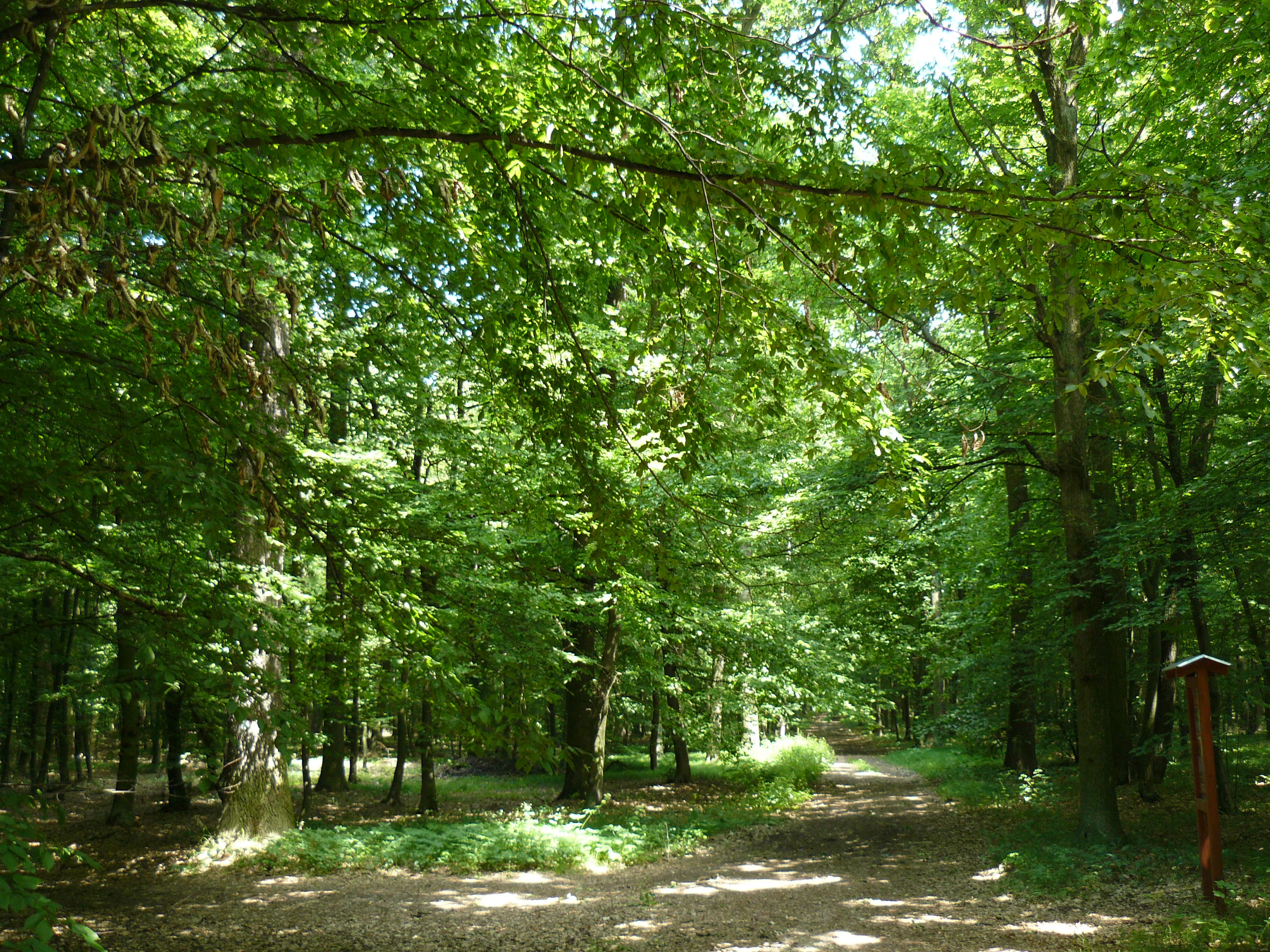
A dirt path leading into a dense green forest with tall, mature deciduous trees, featuring sunlight filtering through the canopy and a small wooden post marker on the right.
A shaded trail path winding through the deciduous oak-hornbeam forest of Veselský háj.

Veselský háj history and protected-area timeline

Veselský háj was first declared a natural monument in 1998, initially under the combined name Veselský háj a rybník Smrkovák, covering roughly 106 hectares near the village of Sběř. The original declaration recognized two distinct values: the forest itself, prized for its thermophilic plant communities, and the adjacent Smrkovák fishpond, recognized as a significant ornithological site.

In 2011, the fishpond portion was separated out and declared as its own independent natural monument, allowing the woodland to be managed and assessed on its own terms. A further redesignation followed in 2014, when Veselský háj was re-established with a considerably expanded footprint of approximately 444 hectares covering cadastral territories including Chotělice, Smidary, Staré Smrkovice, Vysoké Veselí, and Velešice. The 2014 declaration placed the conservation focus firmly on the oak-hornbeam and acidophilous oak forest habitats, and on creating favorable conditions for several strongly threatened plant species.

Veselský háj landscape and geographic character

The landscape of Veselský háj is shaped by the gentle topography of the Bohemian lowlands, with elevations ranging only from about 254 to 280 meters above sea level. There are no steep slopes, cliffs, or dramatic landforms here; instead, the terrain is a soft mosaic of low hills, shallow valleys, and flat stretches that have historically supported a mix of woodland, meadows, and fishponds.

The forest itself contributes strongly to the visual character of the area. Mature oak and hornbeam trees create a relatively open, light-filtering canopy, while the varied structure of the woodland produces an irregular, natural-looking skyline rather than the dense, uniform appearance of commercially managed forest. Patches of older acidophilous oak forest, with their distinctive rough-barked oaks and grassy understory, add further texture to the scene.

Beyond the woodland, the surrounding land retains a classic Bohemian rural character: scattered villages, small agricultural fields, and the open water of the Smrkovák fishpond reflecting the sky on quiet days. Together, these elements form a tranquil lowland landscape where natural and cultural features are tightly interwoven.

Veselský háj ecosystems, habitats, and plant life

Ecologically, Veselský háj belongs to the warm lowland forests of central Bohemia, where continental climate influences, light soils, and a long history of relatively low-intensity land use have produced distinctive forest communities. The defining association is Galio-Carpinetum, a typical oak-hornbeam woodland in which oak species and hornbeam share the canopy with a rich mixture of other broadleaf trees.

Alongside this core forest type, the site includes older stands of acidophilous oak forest. These two forest types together host an unusually rich herbaceous layer, including warmth-loving species such as superb pink and Siberian iris, as well as woodland orchids like violet helleborine. The presence of variegated monk's hood adds further botanical significance, as it depends on relatively undisturbed, structurally diverse broadleaf forest.

The combination of varied light conditions, soil types, and forest age classes gives the reserve a layered ecological structure: closed canopy, semi-open gaps, shrub-dominated patches, and herb-rich clearings. This structural diversity is in turn what allows the site to support such a wide range of specialist plant species, and it is the central reason the area has been given formal protection.

Veselský háj wildlife and species highlights

Although the primary identity of Veselský háj is botanical, the woodland and its proximity to the Smrkovák fishpond create meaningful habitat for a range of wildlife. The structure of the oak-hornbeam forest, with mature trees, dead wood, and a diverse understory, supports typical lowland forest fauna, including woodland birds, small mammals, and insects associated with old broadleaf trees.

The adjoining fishpond was historically recognized as a significant ornithological locality, and although it is now declared as a separate natural monument, its ecological relationship with the surrounding forest remains important for birdlife. Ponds set within or beside lowland woodland tend to support rich communities of waterbirds and serve as feeding and resting areas during migration.

Forests of this character in the Bohemian lowlands also play a broader role as refuges for species that have retreated from intensively farmed surroundings. The dense canopy, leaf litter, and shrub layer offer shelter and foraging habitat for many species that struggle to survive in the modern agricultural matrix that dominates much of the region.

Veselský háj conservation status and protection priorities

The conservation value of Veselský háj lies in the preservation of a near-natural lowland forest that has become rare in the modern Czech landscape. Most of the original lowland broadleaf forests of Bohemia have been lost to clearance, agricultural conversion, or replacement by conifer plantations, so the survival of a mature oak-hornbeam woodland of this size and quality is ecologically significant.

The 2014 re-designation strengthened the site's role in protecting both forest habitat types and a specific set of threatened plant species. By explicitly recognizing superb pink, Siberian iris, variegated monk's hood, and violet helleborine as target species, the protection order tied habitat preservation directly to the recovery and persistence of species that are classified as strongly threatened at the national level.

The site is administered by the Czech Agency for Nature Conservation and Landscape Protection (AOPK ČR), which coordinates habitat management, monitoring, and species protection across the country's protected areas. In the wider landscape context, Veselský háj contributes to habitat connectivity in a region where natural forest fragments have otherwise become isolated, helping to maintain ecological processes across the eastern Bohemian lowlands.

Veselský háj cultural meaning and human context

Veselský háj sits within one of the long-settled rural landscapes of eastern Bohemia, where villages such as Sběř, Smidary, Staré Smrkovice, Vysoké Veselí, and Velešice have shaped the surrounding countryside for centuries. The forest and the nearby fishponds are part of a centuries-old cultural pattern in which lowland woodlands were managed alongside ponds, fields, and small communities.

Fishpond systems like Smrkovák are a signature element of the Bohemian landscape and reflect historical traditions of pond management that predate modern conservation frameworks. The proximity of forest and water in this part of the country is not just an ecological feature; it is also a reminder of how closely Czech rural identity has always been tied to working with the natural landscape.

Today, the area remains an example of integrated countryside where natural values, traditional land use, and small rural settlements coexist, giving the protected site a strong local and regional identity rather than the feeling of an isolated reserve set apart from human activity.

Top sights and standout views in Veselský háj

The oak-hornbeam forests of the Galio-Carpinetum association, representing some of the best-preserved examples of this lowland woodland type in the region.

Mature stands of acidophilous oak forest with sessile oak, providing old-forest structure and habitat complexity.

A rich thermophilic understory hosting threatened species such as superb pink, Siberian iris, variegated monk's hood, and violet helleborine.

A close ecological connection to the Smrkovák fishpond, adding wetland and ornithological value to the broader landscape mosaic.

Best time to visit Veselský háj

The character of Veselský háj changes noticeably with the seasons, and each period offers a different way to experience the woodland. Late spring is especially rewarding for wildflowers, when the thermophilic understory comes into bloom and the herb layer of the oak-hornbeam forest is at its most vivid.

Early summer brings lush, fully leafed canopy and a deep green atmosphere across the woodland, with cooler, shaded conditions along the forest paths. Autumn transforms the site once again, as the broadleaf canopy turns color and the forest floor becomes richer in fruiting bodies and fallen leaves, while the surrounding lowland landscape takes on a softer, mistier quality typical of the Bohemian countryside.


Monthly climate preview

Long-term representative monthly temperature and precipitation patterns

Veselský háj Climate Normals and Annual Temperature Rhythm

Veselský háj records measured average temperatures ranging from sub-zero winter minimums to warm summer highs alongside consistent monthly precipitation values across the year. Reviewing the complete twelve-month climate profile provides detailed historical baseline data for this representative protected coordinate.
Annual mean7 °C
-4 °C18 °C
Jan-4°
Feb-2°
Mar
Apr
May12°
Jun16°
Jul18°
Aug18°
Sep13°
Oct
Nov
Dec-2°
Warmest month
July

18.1 °C

Coolest month
January

-3.7 °C

Wettest month
July

3.1 mm/day

Driest month
April

1.4 mm/day

Park location guide

Geography guide, regional context, and park location map for Veselský háj

Veselský háj park geography, regions, and map view in Czechia

Understand where Veselský háj sits in Czechia through a broader geographic reading of the surrounding landscape, nearby location context, and its mapped position within the national park landscape.

How Veselský háj fits into Czechia

Czech Republic is a landlocked Central European country with a population of approximately 10.9 million people. The nation was established as an independent state on January 1, 1993, following the dissolution of Czechoslovakia. Its capital and largest city is Prague, with other major urban centers including Brno, Ostrava, Plzeň, and Liberec.

Wider geography shaping Veselský háj in Czechia

The Czech Republic is a landlocked country in Central Europe. It is bordered by Germany to the west, Austria to the south, Poland to the northeast, and Slovakia to the southeast. The landscape is predominantly hilly, with the territory covering 78,871 square kilometers.

Map view of Veselský háj

Use this park location map to pinpoint Veselský háj in Czechia, understand its exact geographic position, and read its mapped placement within the surrounding landscape more clearly.

Pigeon | © OpenStreetMap contributors

Location context for Veselský háj

Královéhradecký kraj
Recorded earthquake history

Examine Historical Earthquake Records Associated with Veselský háj

Browse the documented seismic history for the Veselský háj protected area. This curated catalogue allows for the exploration of historical earthquakes identified by location near the monument, providing reliable seismic data and epicentre distances for those studying the regional geography of Královéhradecký kraj.

Veselský háj Earthquake History

Catalogued events

4 events

Strongest magnitude

Magnitude 4

Most recent event

Oct 25, 2005

This history includes earthquakes recorded inside the park or within 50 km of its borders

Explore detailed imagery of oak-hornbeam forest habitats, wetland fishponds, and lowland terrain.

Veselský háj Photos and Landscapes, Visualizing the Bohemian Protected Woodland

Visual records reveal the mature broadleaf canopy, structured understory flora, and gentle topography defining Veselský háj. Photographic documentation provides deeper insight into the conservation value and environmental character of this Bohemian protected area.

A dirt path leading into a dense green forest with tall, mature deciduous trees, featuring sunlight filtering through the canopy and a small wooden post marker on the right.

Park atlas

Compare adjacent woodland reserves and regional conservation landscapes

Explore Protected Areas and Parks Near Veselský háj in the Bohemian Lowlands

Continue browsing other parks near Veselský háj to examine similar lowland forest reserves and regional woodland ecosystems across the Czech countryside. Connecting individual protected areas reveals broader patterns in habitat connectivity and regional terrain variation.
A minimalist watercolor painting showing a horizontal landscape with a pond in the foreground, green fields in the midground, and soft rolling hills in the background.
Natural monumentKrálovéhradecký
About 18 km away#1 closest

Northwest

Rybník Jíkavec Natural Monument: Mapping Protected Wetland Habitats in Královéhradecký

A preserved pond and meadow landscape in central Czechia

Rybník Jíkavec protects a compact cluster of wetland habitats, including open water and sedge-rich meadows within the Královéhradecký region. This nature monument highlights the ecological importance of traditionally managed fishponds and their role in maintaining rare inland marsh flora across the local Bohemian countryside.

Area
0.073 km²
Established
1998
IUCN
IV
Relief
Lowland
Natural monumentKrálovéhradecký kraj
18 km away#2 closest

South

Víno Natural Monument: Mapped Protected Landscapes and Geographic Overview

Protected oak and hornbeam forest in eastern Bohemia

Víno Natural Monument is a significant protected area within the Královéhradecký kraj region, focused on the conservation of century-old broadleaf woodland. This location preserves essential deadwood microhabitats and diverse plant species, offering a clear example of lowland forest ecology integrated into the cultivated landscape of eastern Bohemia.

Area
0.725 km²
Established
2013
IUCN
III
Relief
Lowland
Watercolor illustration of sandstone rock towers and coniferous trees in a landscape setting with a light color palette.
Nature reserveKrálovéhradecký kraj
About 19 km away#3 closest

Northwest

Prachovské skály Nature Reserve: Geologic Atlas of Bohemian Sandstone Formations

Mapped sandstone towers and protected forest terrain in Královéhradecký kraj

Prachovské skály consists of a concentrated sandstone massif characterized by towering pinnacles and labyrinthine gorges. This nature reserve serves as a prime example of sedimentary erosion in the Bohemian Paradise region, offering a distinct landscape profile that stands in sharp contrast to the surrounding agricultural plains of the Czech Republic.

Area
2.624 km²
Established
1928
IUCN
IV
Visitors
300K annual
Natural monumentKrálovéhradecký kraj
23 km away#4 closest

East

Vražba Natural Monument: Botanical Geography and Protected Lands in Královéhradecký Kraj

A rare habitat for critically endangered Central European flora.

Vražba is a specialized protected area located in the Královéhradecký region, designated primarily to stabilize populations of the critically endangered ladybells. Its landscape consists of managed woodland edges and semi-open grassland patches, creating a highly specific environment for rare botanical communities. This site stands as a prime example of targeted habitat management within the broader Czech protected-area network.

Area
0.078 km²
Established
2011
IUCN
III
A watercolor illustration of rolling hills with a treeline and meadow, featuring soft green and orange tones on a white background.
Natural monumentKrálovéhradecký kraj
About 24 km away#5 closest

Northwest

Na víně Natural Monument: Protected Opoka Slopes and Botanical Geography in Královéhradecký kraj

Geographic atlas and ecological profile of a protected Czech natural monument

Na víně represents an essential, small-scale protected landscape in the Jičín District of Královéhradecký kraj. This site is defined by its characteristic calcareous opoka hill slopes and its role as a botanical refuge for rare, thermophilous species. By mapping the interaction between the underlying Cretaceous geology and the surviving dry grassland communities, this analysis highlights the importance of localized conservation within the broader Bohemian Cretaceous Basin.

Area
0.055 km²
Established
1990
IUCN
IV
Relief
Upland
A horizontal watercolor painting depicting a soft landscape with green hills, light forest foliage, and a water body in a muted, warm color palette.
Protected landscapeMladá Boleslav District
About 27 km away#6 closest

West

Přírodní park Čížovky: Geographic Overview of the Protected Landscape in Mladá Boleslav District

Mapping wetlands, aquatic ecosystems, and rural terrain

Přírodní park Čížovky serves as a significant protected landscape in the Mladá Boleslav District. It features a dense mosaic of ponds, marshes, and orchards. Explore the mapped boundaries of this terrain, ranging from the Křesovský potok valley to the elevated Křemenice ridge, showcasing a classic Central Bohemian ecological heritage.

Area
386 km²
Established
1998
Relief
Upland
Climate
Temperate
Watercolor painting showing a river, grassy banks, scattered trees, and distant hills
Protected landscapeCzechia
About 29 km away#7 closest

Northwest

Bohemian Paradise Protected Landscape: Discover Czech Republic's Sandstone Geology and Park Boundaries

Mapped sandstone formations and historic regional geography.

Delve into Bohemian Paradise, a protected landscape in the Czech Republic celebrated for its dramatic sandstone rock formations and ancient castles. This detailed entry provides context on its unique geological character, the extent of its protected boundaries, and its significant position within the regional geography. Explore the mapped terrain and understand the atlas value of this historic protected area.

Area
181.17 km²
Established
1955
IUCN
V
Relief
Upland
Watercolor painting of a peaceful wetland landscape with a winding stream, soft rolling hills in the background, and wild meadow vegetation in the foreground.
Natural monumentKrálovéhradecký kraj
About 29 km away#8 closest

Southeast

Roudnička a Datlík Natural Monument: Wetland Geography and Protected Landscape Context

A vital ecological refuge within the Královéhradecký landscape.

Roudnička a Datlík protects a rare wetland mosaic of fishponds, reedbeds, and purple moor-grass meadows on the edge of the East Bohemian table. This natural monument remains a key site for regional conservation management, supporting a variety of orchids and waterbirds within an urban-fringe environment. Explore the site's mapped boundaries and its role in protecting lowland biodiversity.

Area
0.297 km²
Established
1988
IUCN
IV
Relief
Lowland

Common questions about visiting, size, designation, and location context for Veselský háj

Veselský háj FAQs for park facts, access, geography, and protected area context

Find quick answers about Veselský háj, including protected-area facts, park geography, trail and visitor context, and how the park fits into its surrounding country and regional landscape.
MoriAtlas Explorer

Continue Your Protected Areas Search Across the Global Atlas

Deepen your exploration by continuing the structured search for national parks and protected areas worldwide. Utilize the comprehensive filtering capabilities to compare different conservation landscapes and refine your understanding of global park geography. Discover more about the distribution and characteristics of protected natural areas.

Global natural geography