
Mori Atlas logo
Natural monumentVeveřský potok

Mapping the ecological transition between the Novohradské podhůří foothills and mountains

Veveřský potok Natural Monument: A Protected Stream Valley in the Jihočeský kraj Region

(Přírodní památka Veveřský potok)

Veveřský potok is a protected natural monument in the Jihočeský kraj that safeguards a five kilometer upper mountain stream valley. This site serves as a vital corridor for freshwater biodiversity, marking the transition from upland foothills to the more rugged terrain of the Novohradské hory. By maintaining natural riffle and pool sequences, the area provides essential habitat for endangered species at the edge of the Czech-Austrian border.

natural monumentstream valleyfreshwater conservationbrook lampreyNatura 2000Novohradské hory
A flat-style digital illustration depicting a winding brook flowing through a forest valley toward a waterfall cascading down a cliff face beneath a yellow sun.

Veveřský potok

Natural monument

Park overview

Structured park overview, official facts, and landscape profile for Veveřský potok

Veveřský potok park facts, protected area profile, and essential visitor context

Review the core facts for Veveřský potok, including designation, size, terrain, visitor scale, habitats, and operating context in one park-focused overview.

About Veveřský potok

Veveřský potok is a protected stream valley in the České Budějovice District of South Bohemia, designated as a přírodní památka, or natural monument. The site follows the upper course of the Veveřský potok, a small mountain stream that rises in the Novohradské hory along the Czech-Austrian border and then drops northward through the foothills toward the town of Nové Hrady. The protected area covers roughly 34.47 hectares and spans the cadastral territories of Mýtiny and Veveří u Nových Hradů, with the stream corridor protected for almost five kilometers in length.

The monument lies within the larger Novohradské hory Natural Park, which provides a buffer of protected landscape around the stream valley, and borders the Novohradsko landscape memorial zone to the north. Elevation within the protected area ranges from about 514 to 685 meters above sea level, giving the site a distinct foothills-to-mountain character. The valley is narrow, with the stream running through a wooded catchment that has retained relatively natural conditions despite its proximity to a long-standing settlement.

Veveřský potok was declared on 11 November 2013 by decree of the South Bohemian Regional Authority, after the site had been identified as a European Important Site for its freshwater fauna. The protection is specifically focused on conservation of the European brook lamprey and its habitat. Aside from the lamprey, the stream supports other rare and threatened aquatic species typical of clean upland waters in Central Europe, which together give the site significance disproportionate to its small area.

Quick facts and research context for Veveřský potok

Veveřský potok is a natural monument (přírodní památka) in the České Budějovice District of South Bohemia, Czech Republic. It was declared by the South Bohemian Regional Authority on 11 November 2013 and covers about 34.47 hectares along the upper course of the Veveřský stream. The protected area lies within the Novohradské hory Natural Park, near the town of Nové Hrady, at elevations between roughly 514 and 685 meters above sea level. The site is designated primarily for the conservation of the European brook lamprey, a species tied to clean, well-oxygenated upland streams.

Protection and recognition

Documented terrestrial protection scope and Natura 2000 listings

Veveřský potok Protection Status and International Recognition Data

Terrestrial protection status for Veveřský potok encompasses verified administrative boundaries and official Natura 2000 recognition records. Structured conservation data provides reliable reference points for evaluating the managed natural landscape.

International recognition

Protection details

Protection scope
Terrestrial
Transboundary protection
No
Park context

Deeper park guide and search-rich context for Veveřský potok

Veveřský potok history, landscape, wildlife, and travel context

Explore Veveřský potok through its history, landscape character, ecosystems, wildlife, conservation priorities, cultural context, and seasonal travel timing in a structured park guide built for atlas discovery and search intent.

Why Veveřský potok stands out

Veveřský potok is best known for safeguarding a population of the critically endangered European brook lamprey (Lampetra planeri), one of the most sensitive indicator species of clean European freshwater habitats. The protected stream valley has been formally recognized as a European-significant locality (evropsky významná lokalita) because of the lamprey's presence and the quality of its spawning and larval substrate. Beyond the lamprey itself, the site is valued for the broader integrity of an upper-course mountain stream that retains natural flow, substrate, and riparian conditions. This makes Veveřský potok a small but ecologically meaningful reference site for the conservation of pristine montane stream systems in the Novohradské hory region and for the wider Natura 2000 framework in the Czech Republic.
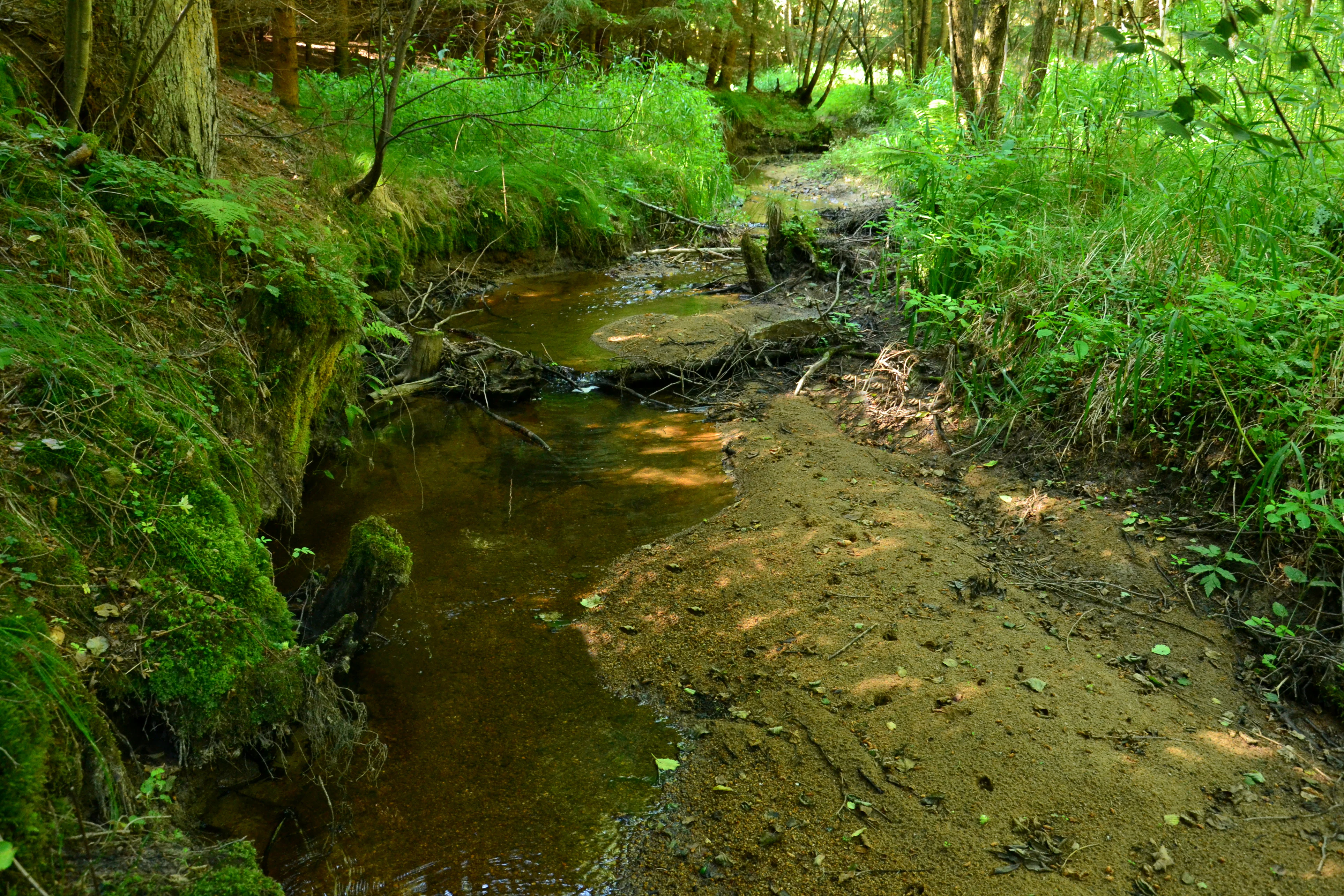
A small, shallow brook flows through a lush, green forest, with a sandy bank to the right and mossy, tree-lined banks to the left.
The Veveřský potok brook meandering through the forest, showcasing the protected valley ecosystem.

Veveřský potok history and protected-area timeline

The history of Veveřský potok as a protected area is recent: it was formally declared a natural monument by the Krajský úřad Jihočeského kraje (South Bohemian Regional Authority) on 11 November 2013, through regional decree no. 26/2013. The designation followed recognition of the valley as a European Important Site tied to the presence of the European brook lamprey and associated freshwater fauna.

The broader landscape, however, carries much older layers of human use. The Ivanův pramen (Ivan's Spring) near the headwaters of the stream has served as a documented source of drinking water for the town of Nové Hrady since 1639, making it one of the historically significant springs of the region. The catchment also retains traces of twentieth-century borderland history: the former village of Jedlice, lying close to the spring, was depopulated and dismantled during the construction of the Iron Curtain, after which the upper valley became part of a tightly restricted frontier zone adjoining Austria.

These historical threads, from medieval-era water supply to Cold War depopulation, do not directly shape the conservation purpose of the site but help explain why the upper stream corridor has remained in a relatively natural state and why scientific surveys have found habitat conditions suitable for sensitive species such as the lamprey.

Veveřský potok landscape and geographic character

The landscape of Veveřský potok is defined by a narrow, forested stream valley that connects two distinct physiographic units: the gentler Novohradské podhůří foothills to the north and the steeper, higher Novohradské hory mountains to the south. Within the protected area, elevations rise from roughly 514 meters at the lower end to about 685 meters in the upper valley, lending the site a clear vertical gradient over a relatively short horizontal distance.

The stream corridor itself is tightly incised, with the Veveřský potok running through a shaded, mostly wooded catchment. Natural riffle and pool sequences, gravelly substrates, and intact riparian vegetation characterize the upper course, while the headwater area near the former village of Jedlice lies close to 700 meters in elevation. The valley sits at the very edge of the Czech Republic, with the spring area only about 200 meters from the Czech-Austrian border, so that the natural monument effectively forms part of the broader cross-border forest mosaic of the Bohemian Forest flank.

The result is a compact but visually distinct landscape: a transition zone where upland foothills give way to the cooler, more continental montane forests of the Novohradské hory. Although the protected area is small, its landscape setting remains largely natural and contributes directly to the ecological conditions that make the site important for freshwater biodiversity.

Veveřský potok ecosystems, habitats, and plant life

Ecologically, Veveřský potok belongs to the cool, well-oxygenated upland stream systems typical of the Bohemian Forest fringe. The protected corridor preserves a near-natural stream environment with intact riparian forest cover, varied bottom substrates, and relatively undisturbed hydrology, providing habitat conditions that have largely disappeared from more accessible Czech lowland and mid-elevation waters.

Vegetation along the stream reflects this transitional setting, with mixed deciduous and coniferous woodland characteristic of the Novohradské hory foothills-to-mountains gradient. The damp, shaded conditions maintain moisture-loving understory communities, while the forested catchment limits nutrient input and maintains the clean water quality on which the site's fauna depends.

Faunistically, the protected area is dominated by freshwater rather than terrestrial values. The valley is recognized within the European Natura 2000 context as a European Important Site primarily because it supports species assemblages that depend on undisturbed upper-course streams. The integrity of the stream ecosystem, more than the area of land around it, is what gives the natural monument its conservation meaning.

Veveřský potok wildlife and species highlights

The wildlife value of Veveřský potok is overwhelmingly freshwater-focused, and within that framework it is dominated by a single, highly distinctive species: the European brook lamprey (Lampetra planeri). The brook lamprey is a small, jawless fish whose larvae spend years buried in clean stream sediments before metamorphosis, making the species a classic indicator of high-quality, undisturbed upland streams. It is classified as critically endangered in the Czech Republic, and the Veveřský potok population is one of the key reasons the valley was formally designated.

The same stream habitat that supports the lamprey also sustains other rare and threatened aquatic species typical of clean, well-oxygenated Central European mountain brooks. Because the designation explicitly cites the protection of rare and endangered animal species, the site's faunal importance is recognized at the European level rather than just locally.

Terrestrial wildlife within the protected corridor is limited by the narrow, linear shape of the valley, but the surrounding Novohradské hory Natural Park provides a broader forest context for forest-interior species. From the perspective of the natural monument itself, however, the brook lamprey and the wider freshwater assemblage remain the defining wildlife feature.

Veveřský potok conservation status and protection priorities

Veveřský potok is a conservation site of European relevance despite its very small area. It has been formally recognized as an evropsky významná lokalita, a category of important European site within the Natura 2000 framework, because of the presence of the European brook lamprey and the supporting condition of its stream habitat. Its declaration in 2013 by the South Bohemian Regional Authority explicitly cites the protection of rare and endangered animal species as its purpose.

The conservation significance of the site extends beyond the lamprey itself. By protecting almost five kilometers of an intact upper stream valley, the natural monument preserves a complete functional unit of mountain stream habitat, including spawning substrates, larval sediments, shaded riparian cover, and the hydrological conditions needed for sensitive aquatic species to complete their life cycles. This makes the site disproportionately important for freshwater conservation in the Novohradské hory region.

The site is also embedded in a wider network of protected landscape. It lies within the Novohradské hory Natural Park and borders the Novohradsko landscape memorial zone to the north, situating this small natural monument within a layered system of regional and landscape-level protections that reinforce its ecological value.

Veveřský potok cultural meaning and human context

Although primarily a conservation site, Veveřský potok carries meaningful cultural layers rooted in long-standing human dependence on the landscape. The headwater spring near the former village of Jedlice has served as a documented source of drinking water for the town of Nové Hrady since 1639, linking the upper valley to centuries of municipal water supply in the region.

The broader upper catchment also reflects the more recent history of the Czech-Austrian borderland. The former settlement of Jedlice and the nearby locality of Veveří were depopulated during the construction of the Iron Curtain in the twentieth century, leaving the upper valley as one of the depopulated frontier zones along today's Czech-Austrian border. This historical depopulation helps explain why the stream environment has remained in a relatively natural state.

The lower end of the protected corridor, by contrast, lies close to living settlements, including the town of Nové Hrady and the hamlet of Veveří. The natural monument thus sits at an interface between a sparsely populated, historically emptied borderland and an actively used South Bohemian cultural landscape shaped by Nové Hrady and its surroundings.

Top sights and standout views in Veveřský potok

Veveřský potok stands out as a small but ecologically focused natural monument whose value rests on the integrity of an upper mountain stream and the European importance of its freshwater fauna. Its declaration in 2013 formalized the protection of a population of the critically endangered European brook lamprey, raising the profile of a stream valley that local people have known and used for centuries.

Best time to visit Veveřský potok

As a small freshwater-focused natural monument, Veveřský potok is best appreciated in late spring and summer, when low water levels reveal the stream's riffle-and-pool structure and the forest canopy is fully leafed out. Cooler, rainy periods also highlight the hydrology that supports the lamprey and other sensitive aquatic species. Late autumn and winter can offer quieter visits but bring colder, more humid conditions in the foothills, and the dense forest cover limits visibility year-round. Visitors should remember that the protected area is a conservation site first, with limited formal access infrastructure, and is best explored as part of a broader walk through the Novohradské hory Natural Park rather than as a stand-alone destination.

Monthly climate preview

Long-term representative point measurements tracking monthly temperature and precipitation rhythm

Veveřský potok Climate Normals and Measured Annual Weather Patterns

Representative coordinates record long-term monthly temperature swings alongside shifting daily precipitation rates across the landscape. Examining the full twelve-month profile reveals detailed baseline climate normals for comprehensive geographic research.
Annual mean8 °C
-3 °C19 °C
Jan-3°
Feb-2°
Mar
Apr
May13°
Jun17°
Jul19°
Aug19°
Sep13°
Oct
Nov
Dec-2°
Warmest month
July

18.7 °C

Coolest month
January

-3 °C

Wettest month
July

2.9 mm/day

Driest month
February

1.1 mm/day

Park location guide

Geography guide, regional context, and park location map for Veveřský potok

Veveřský potok park geography, regions, and map view in Czechia

Understand where Veveřský potok sits in Czechia through a broader geographic reading of the surrounding landscape, nearby location context, and its mapped position within the national park landscape.

How Veveřský potok fits into Czechia

Czech Republic is a landlocked Central European country with a population of approximately 10.9 million people. The nation was established as an independent state on January 1, 1993, following the dissolution of Czechoslovakia. Its capital and largest city is Prague, with other major urban centers including Brno, Ostrava, Plzeň, and Liberec.

Wider geography shaping Veveřský potok in Czechia

The Czech Republic is a landlocked country in Central Europe. It is bordered by Germany to the west, Austria to the south, Poland to the northeast, and Slovakia to the southeast. The landscape is predominantly hilly, with the territory covering 78,871 square kilometers.

Map view of Veveřský potok

Use this park location map to pinpoint Veveřský potok in Czechia, understand its exact geographic position, and read its mapped placement within the surrounding landscape more clearly.

Pigeon | © OpenStreetMap contributors

Location context for Veveřský potok

Jihočeský kraj
Recorded earthquake history

Browse the Historical Earthquake Catalogue for Veveřský potok

Explore a detailed record of seismic events identified within the region surrounding Veveřský potok. MoriAtlas provides a clean, factual interface for viewing USGS-derived earthquake history, including event magnitude and epicentre distance, to support a deeper understanding of local landscape geography.

Veveřský potok Earthquake History

Catalogued events

2 events

Strongest magnitude

Magnitude 3.4

Most recent event

Mar 11, 2000

This history includes earthquakes recorded inside the park or within 50 km of its borders

Visual exploration of protected stream valleys, upland forests, and freshwater habitats.

Veveřský potok Photos and Landscape Scenery in the Novohradské Hory Mountains

Visual documentation of Veveřský potok reveals the narrow forested stream valley, shaded riparian vegetation, and steep elevation gradients connecting the upland foothills to the mountain range. Examining these protected area environments provides a clearer understanding of the terrain, freshwater habitats, and natural morphology defining the protected stream corridor.

A small, shallow brook flows through a lush, green forest, with a sandy bank to the right and mossy, tree-lined banks to the left.

Park atlas

Compare adjacent stream valleys and regional protected landscapes across the border zone

Explore Other Parks Near Veveřský potok and Protected Areas in the Surrounding Region

Browse protected areas and natural monuments located near Veveřský potok to understand the wider ecological context of the upland foothills. Comparing these neighboring stream valleys reveals broader patterns of freshwater conservation across the regional mountain terrain.
Watercolor painting of a soft landscape with rolling hills and patches of deciduous trees in shades of green, yellow, and faint red, set against a plain white background.
Natural monumentJihočeský kraj
1.4 km away#1 closest

North

Sokolí hnízdo a bažantnice Natural Monument: A South Bohemian Protected Broadleaf Woodland

Mapping the ecological boundaries and woodland history of this South Bohemian protected area.

Sokolí hnízdo a bažantnice constitutes a critical natural monument in the South Bohemian region of the Czech Republic. Positioned along the Stropnice River, this protected landscape preserves mature deciduous woodland habitats and essential invertebrate populations that define the biodiversity character of the Třeboň Basin.

Area
0.475 km²
Established
2014
Relief
Lowland
Climate
Temperate
Nature reserveJihočeský kraj
18 km away#2 closest

West

Velký Hodonický rybník Nature Reserve: Regional Geography and Protected Wetland Atlas

Mapped aquatic habitats in the South Bohemian foothills

Situated in the Novohradské podhůří, Velký Hodonický rybník is a protected nature reserve defined by its shallow fishpond basin and specialized wetland flora. This site acts as a key element of the Natura 2000 network, preserving rare aquatic vegetation and amphibian populations within a characteristic South Bohemian landscape. The area offers a detailed view into the intersection of historical agricultural land use and contemporary environmental preservation.

Area
0.027 km²
Established
2023
IUCN
III
Nature reserveJihočeský kraj
About 31 km away#3 closest

Northwest

Vltava u Blanského lesa: Protected Natural Monument and River Valley Geography

Mapping the riparian landscape and conservation corridors in Jihočeský kraj

Situated in the Jihočeský kraj, Vltava u Blanského lesa is a designated nature reserve encompassing a unique river valley corridor. This area bridges the transition between aquatic river habitats and surrounding terrestrial meadows, protecting a structural mosaic essential for threatened plant and animal populations across several kilometers of the upper Vltava.

Area
4.78 km²
Established
2014
IUCN
III
Relief
Upland
A horizontal watercolor painting showing a pale landscape with faint rolling hills in the background and soft green tree silhouettes in the foreground.
Natural monumentJihočeský kraj
About 33 km away#4 closest

North

Slepičí vršek Natural Monument: Exploring Inland Sand Dune Geography in the Třeboň Basin

Protected psammophilous landscape in Jihočeský kraj

Slepičí vršek represents a distinct eolian feature within the broader Třeboňsko landscape, characterized by its dry, undulating sandy soil and rare vegetation. This protected monument offers a clear case study for understanding inland dune development and the specialized biodiversity of relict habitats within the South Bohemian Region.

Area
0.019 km²
Established
1955
IUCN
III
Relief
Lowland
Natural monumentJihočeský kraj
About 37 km away#5 closest

Northwest

Vrbenská tůň Natural Monument: Wetland Geography and Protected Landscape Analysis

A significant oxbow wetland fragment in the South Bohemian region.

Vrbenská tůň functions as a protected natural monument focused on the conservation of lowland pond ecosystems. Located within the Jihočeský kraj, this area offers a window into the hydrology of the České Budějovice Basin, supporting specialized amphibian populations and aquatic flora within its restored basin and surrounding buffer zones.

Area
0.009 km²
Established
1974
IUCN
III
Relief
Lowland
Natural monumentJihočeský kraj
About 37 km away#6 closest

West

Výří vrch Natural Monument: Regional Geography and Limestone Habitat Mapping

Protected limestone terrain in Jihočeský kraj

Výří vrch preserves a striking limestone inselberg that rises above the regional upland forests of the Czech Republic. The site provides a critical study in how exposed calcareous geology and warm, dry microclimates support a dense, specialized collection of steppe-like flora and invertebrate species within a broader forest-dominated landscape.

Area
0.129 km²
Established
2010
IUCN
IV
Relief
Upland
A soft watercolor illustration of a pond landscape with grassy banks, reeds, and soft green vegetation in the background.
Nature reserveJihočeský kraj
39 km away#7 closest

Northwest

Rybník Motovidlo Nature Reserve: Geographic Overview and Protected Area Profile

A critical aquatic landscape within the Jihočeský kraj region

Rybník Motovidlo is a specialized nature reserve in the Czech Republic, recognized for its role in conserving endangered aquatic vegetation and providing a refuge for diverse amphibian fauna. Its geographic position within the České Budějovice Basin links it to the broader network of South Bohemian ponds. The site serves as a vital case study for the integration of traditional pond management with modern biodiversity protection in a wetland-focused environmental context.

Area
0.116 km²
Established
2022
IUCN
III
Relief
Lowland
Watercolor illustration of a soft, rolling landscape with purple hills in the distance and pale green and pink vegetation in the foreground.
Natural monumentJihočeský kraj
About 41 km away#8 closest

West

Meandry Chvalšinského potoka Natural Monument: Mapped River Geography and Valley Terrain

Protected riparian habitat in the South Bohemian landscape

This natural monument protects a remarkably intact stretch of the Chvalšinský potok, where natural meanders, cut banks, and point bars create a living laboratory of fluvial geography. Beyond the stream itself, the site encompasses moist thistle and sedge meadows, offering a clear view into the traditional wetland ecology of the region. As a protected enclave, it maintains essential hydrological integrity within the broader landscape of the Czech countryside.

Area
0.048 km²
Established
2001
IUCN
IV
Relief
Lowland

Common questions about visiting, size, designation, and location context for Veveřský potok

Veveřský potok FAQs for park facts, access, geography, and protected area context

Find quick answers about Veveřský potok, including protected-area facts, park geography, trail and visitor context, and how the park fits into its surrounding country and regional landscape.
MoriAtlas Explorer

Continue Your Protected Areas Search Across the Global Atlas

Deepen your exploration by continuing the structured search for national parks and protected areas worldwide. Utilize the comprehensive filtering capabilities to compare different conservation landscapes and refine your understanding of global park geography. Discover more about the distribution and characteristics of protected natural areas.

Global natural geography