
Mori Atlas logo
Natural monumentVidoule

Examining the geological profile, Cretaceous rock layers, and urban-fringe grassland ecology of this significant natural landmark.

Vidoule Natural Monument: A Protected Table Mountain Within the Prague Plateau Landscape

Vidoule rises as a flat-topped hill above the western districts of Prague, serving as a rare relict of the Prague Plateau. This protected natural monument preserves essential Cenomanian and Turonian geological layers, including sandstone outcrops and marlstone formations that create a striking silhouette against the surrounding urban sprawl. The site supports a complex mosaic of warm-loving steppe vegetation and provides a critical habitat for specialized insect populations and breeding songbirds.

table mountainflat-topped hillCretaceous geologysandstone outcropsdry grasslandsteppe flora
A stylized vector illustration featuring a waterfall cascading from a cliffside table mountain into a river, surrounded by pine trees, shrubs, and grassy slopes under a pale sun.

Vidoule

Natural monument

Park overview

Structured park overview, official facts, and landscape profile for Vidoule

Vidoule park facts, protected area profile, and essential visitor context

Review the core facts for Vidoule, including designation, size, terrain, visitor scale, habitats, and operating context in one park-focused overview.

About Vidoule

Vidoule lies on the western edge of Prague, where the city's urban fabric gives way to one of its last surviving examples of natural plateau terrain. The hill reaches 372 meters in elevation and takes the form of a table mountain, a feature produced by horizontally deposited Cretaceous layers whose edges remain visible as small sandstone cliffs along the boundary of the summit plateau. The protected natural monument, declared in 1988, covers three slope segments on the south, southeast, and north sides of this hill, totaling only about 8.65 hectares.

The setting of Vidoule is unusual for a nature reserve. To the east, the hill is bordered by a road connecting the Cibulka park with the Jinonice district. To the south, the slopes descend toward Butovice, while to the west the protected land blends into a meadow encircling the large Stodůlky housing estate. On the summit one finds a water-supply complex, a school campus, and the remains of a former Czechoslovak air-defense network of bunkers, semi-collapsed buildings, underground passages, roads, and fences clustered near the Odkolek bakery. These structures, together with the growing residential developments of Vidoule and Botanica Vidoule on its flanks, give the reserve a strongly urban-fringe character.

Ecologically, Vidoule is valued primarily as a geological and landscape monument rather than as a wildlife reserve in the traditional sense. The exposed rock layers make it a notable fossil locality, and the combination of dry, south-facing slopes with cooler, sheltered northern ravines produces a striking pattern of microhabitats within a very small area. Within Prague's heavily built-up administrative territory, this mosaic of rock, scrub, dry grassland, and small woodland patches is increasingly rare, lending Vidoule both its protected designation and its broader landscape significance.

Quick facts and research context for Vidoule

Vidoule is a small natural monument in Prague 5, declared on 4 July 1988. Its protected area covers 8.65 hectares across three slope bands on the south, southeast, and north sides of a hill reaching about 372 meters in elevation, which is sometimes seen as part of the broader Říčany and Třebotov plateaus of the Prague Plateau.

The site is classified as an IUCN Category III protected area, a natural monument, and is recorded under code 1107 in the Czech nature conservation register. The hill is notable as an exposed geological section through the Cenomanian Peruc-Korycany Formation, capped by Lower Turonian marlstones and opukas, with older Ordovician shales and sandstones of the Beroun stage lying beneath. Despite being surrounded by infrastructure, including the Cibulka park road, the Odkolek bakery, a German school campus, and the Stodůlky housing estate, Vidoule remains one of the last unbuilt plateaus in central Prague.

Protection and recognition

Analysis of terrestrial boundaries, establishment year, and international recognition records

Vidoule Protection Status and Documented Designation History

Historical records establish the terrestrial protection status and designation year of 1988 for Vidoule. Structured database entries outline the administrative scope and status parameters governing this protected area.

Protection details

Protection scope
Terrestrial
Designated year
1988
Transboundary protection
No
Park context

Deeper park guide and search-rich context for Vidoule

Vidoule history, landscape, wildlife, and travel context

Explore Vidoule through its history, landscape character, ecosystems, wildlife, conservation priorities, cultural context, and seasonal travel timing in a structured park guide built for atlas discovery and search intent.

Why Vidoule stands out

Vidoule is best known as one of Prague's flat-topped hills, a table mountain formed from horizontal Cretaceous sedimentary layers that remain exposed as sandstone outcrops along the edge of the summit plateau. Its protected slopes preserve a Cenomanian geological profile through the Peruc-Korycany Formation, capped by Lower Turonian marlstones and opukas, making it an important local site for fossils. Beyond geology, the hill is recognized for its warm-loving secondary grassland and steppe-character fauna. Open south-facing slopes support heat-demanding grasses such as prapořitá válečka and žlábkatá kostřava, while bush thickets and sheltering vegetation host ground beetles, weevils, and endangered mollusks of steppe affinity. In the wider context of Prague, Vidoule stands out as one of the last remaining unbuilt plateaus within the city limits, a relict landscape feature surrounded by dense urban development.
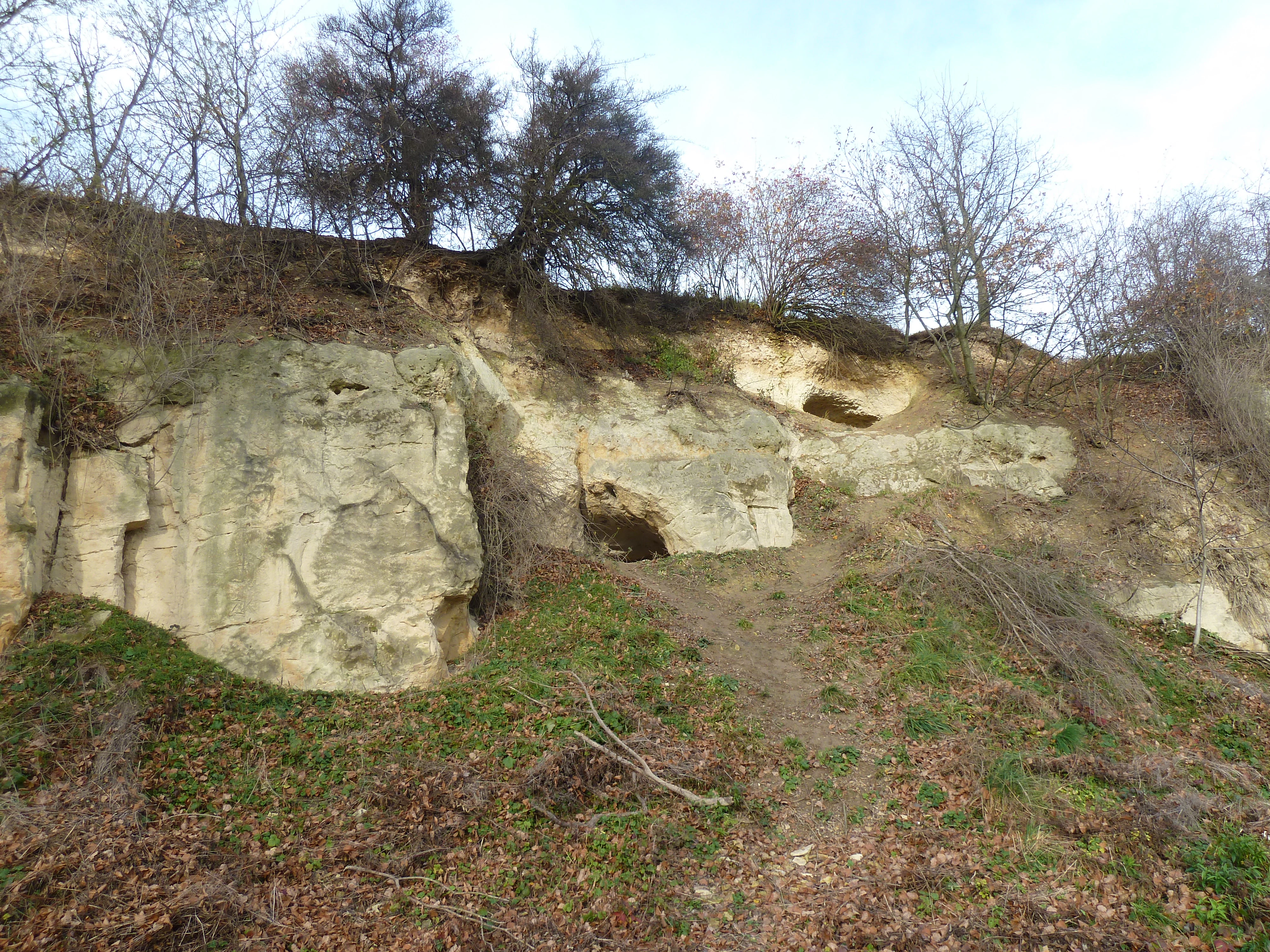
A low angle view of an exposed, light-colored rocky cliff face at Vidoule, with sparse vegetation and bare trees at the top and base.
Exposed sandstone cliff at the Vidoule natural monument, showcasing the site's characteristic geological profile.

Vidoule history and protected-area timeline

Vidoule's original name was Vidova hora. In 1680, during a plague outbreak in Bohemia, victims of the disease were buried on the lower slopes of the hill, an event that left a lasting mark on the local cultural memory. The sandstone formations of the hill were also historically exploited for shelter: rock-cut dwellings carved into the soft stone remained inhabited by poor Prague residents until 1948, and a single such cave, Vidoulská jeskyně on the eastern flank, is still publicly accessible today.

In modern times, the hill became the focus of political debate over development in western Prague. Protivzdušná obrana státu, the Cold War-era air defense network, left behind bunkers, collapsed buildings, underground passages, roads, and fences concentrated on the western part of the summit plateau. After 1989, proposals for further housing construction around Vidoule prompted sustained public discussion about whether to expand the city's residential footprint onto one of its last unbuilt plateaus.

The site itself was designated a přírodní památka, a natural monument, by official declaration on 4 July 1988, formalizing the protection of its three slope bands. Subsequent decades have seen the gradual transformation of the southern flank into new neighborhoods such as Botanica Vidoule, while the protected slopes themselves remain an enclave of geological and ecological value within an expanding city.

Vidoule landscape and geographic character

Vidoule is a textbook example of a table mountain, or stolová hora, embedded in the rolling terrain of the Prague Plateau. Its summit plateau was shaped by horizontal layering of soft Cretaceous rock, with harder sandstones forming a resistant cap and weaker marlstones and opukas sitting beneath. Erosion has trimmed the edges of this cap into small sandstone outcrops and ledges, producing the characteristic cliff-rim profile that defines the hill.

The protected slopes fall into three distinct zones. The southern and southeastern slopes face Butovice and are gentler, crisscrossed by paths, and dressed in warm-loving dry grassland. The northern slope is more rugged and heavily vegetated, with numerous small springs feeding into the Motolský potok stream. Tucked into this dense growth are hidden sandstone walls and the overgrown remains of old structures, which are difficult to access on foot.

The broader landscape around Vidoule has been heavily urbanized. The hill rises almost in isolation above the surrounding districts: Košíře to the east, Butovice to the south, and the large Stodůlky housing estate to the west. The road linking the Cibulka park to Jinonice runs along its eastern foot, while the Odkolek bakery and a school complex occupy parts of the upper plateau. Despite this densely built setting, Vidoule retains the visual character of a natural lookout above western Prague.

Vidoule ecosystems, habitats, and plant life

Vegetation on Vidoule reflects a long history of disturbance and replanting. Much of the surface supports a secondary, species-poor, often semi-ruderal plant community. The slopes of the geological profile are largely overgrown with planted black locust, alongside invasive or spontaneous regeneration of elder, aspen, and goat willow. The northern part of the hill was artificially forested, principally with non-native Scots pine, though some patches below the horizon-level trail on the eastern flank show more natural woodland composition, including an older oak fringe.

The most ecologically interesting zone lies on the former field margins and pastures of the southern slope. Here a thermophilic grassland community has developed, dominated by prapořitá válečka and žlábkatá kostřava, both warmth-loving species characteristic of dry, open Czech lowland sites. The contrast between this open south-facing grassland, the shrubby thickets of the slopes, and the denser pine plantation on the north creates a clear mosaic of microhabitats within a very compact protected area. Soils are predominantly oligobasic brown earths, with localized enrichments from marlstone runoff and frequent disturbance traces of past quarrying.

Vidoule wildlife and species highlights

Despite its small size, Vidoule hosts a surprising assemblage of steppe-affiliated fauna. The most distinctive animals are insects associated with dry, open habitats: notable ground beetles of the genus Ophonus and Cymindis angularis occur here, alongside leaf beetles such as Coptocephala rubicunda and Cryptocephalus violaceus, a flea beetle, a shield beetle of the genus Cassida, and a representative of the Urodontidae family. Flightless weevils including Otiorhynchus fullo and Otiorhynchus velutinus, as well as several Trachyphloeus species, contribute to an unusually rich weevil community for an urban site.

The dry southern slope also supports the endangered steppe snail known as trojzubka stepní, a mollusk of considerable conservation interest in the Czech context. Birdlife is concentrated in the shrubby layers of the slopes, where common species such as the yellowhammer, blackcap, and song thrush breed, with the occasional red-backed shrike and barred warbler. The hill also serves as a brief stopover for migrating common nightingales and other passerines, adding seasonal variety to its otherwise modest avifauna.

Vidoule conservation status and protection priorities

The conservation value of Vidoule lies in the combination of three factors that are rarely found together within a single Prague site: a clearly exposed Cretaceous geological profile, a remnant patch of warm-loving steppe grassland, and the persistence of an undeveloped plateau in an otherwise built-up part of the city. Declaring the area a přírodní památka in 1988 formally protected its southern, southeastern, and northern slopes against further construction and recognized the hill's role as a significant landscape feature of the Prague Plateau.

The site's protected status has particular importance because urbanization has steadily encroached on Vidoule's surroundings. New residential developments such as Botanica Vidoule on the southern slope, the growing Stodůlky housing estate to the west, and the existing water-supply and school complexes on the plateau have effectively ringed the reserve with infrastructure. By preserving even three narrow bands of slope, the monument keeps intact a small but functioning refuge for steppe-character beetles, endangered mollusks, thermophilic grasses, and breeding songbirds that would otherwise be lost from this part of Prague.

At the same time, conservation management on Vidoule faces tangible challenges. Past quarrying has disturbed soils, large parts of the surface have been replanted with non-native species, and the northern slope has been densely afforested with Scots pine. Maintaining the open character of the southern grassland, controlling invasive woody species, and balancing public access near a military-contaminated and partially overgrown summit remain ongoing concerns for the site.

Vidoule cultural meaning and human context

Vidoule carries a layered human history that adds cultural depth to its ecological and geological significance. The hill's earliest documented name, Vidova hora, hints at an older local identity. In 1680, during a major plague epidemic, victims were buried at its foot, an event that tied the landscape to the broader history of hardship in Prague and its surroundings.

The sandstone of the hill also shaped daily life for generations of Prague's poor. Rock-cut dwellings were carved into the soft Cretaceous stone and used as housing well into the twentieth century, with the last such cave-dwellers only leaving in 1948. One of these chambers, the Vidoulská jeskyně on the eastern flank, survives as a publicly accessible heritage feature, a tangible reminder of this period of informal urban habitation.

In more recent decades, the hill became a focal point of public debate about the future of western Prague. The remains of protivzdušná obrana státu, a Cold War-era air-defense network, sit alongside discussions of municipal development plans, new villa neighborhoods such as Vidoule and Botanica Vidoule, and the broader tension between preserving one of the last open plateaus in Prague and meeting the city's growing housing demand.

Top sights and standout views in Vidoule

Vidoule's standout features combine geology, ecology, and urban context in a single compact site. The hill's flat-topped silhouette is itself the most visible highlight, a clearly defined table mountain rising above the surrounding cityscape of Košíře, Butovice, Jinonice, and Stodůlky. Its southern, southeastern, and northern slopes together protect a continuous Cenomanian-Turonian geological profile through the Peruc-Korycany Formation, an unusually well-preserved fossil-bearing section within the Prague Plateau.

Ecologically, the reserve is notable for its mosaic of warm-loving dry grassland, shrubby thickets, and pine plantation concentrated into just a few hectares, and for its role as a refuge for steppe beetles, flightless weevils, and the endangered steppe snail trojzubka stepní. Birdwatchers value the site for breeding yellowhammers, blackcaps, song thrushes, and irregular visiting red-backed shrikes and barred warblers, as well as for passing nightingales during migration.

Equally distinctive is the hill's setting: a working water-supply complex, a school campus, the Odkolek bakery, the ruins of Cold War bunkers, and a growing garden suburb all coexist with this fragile protected slopes, making Vidoule one of the most unusually urban-facing natural monuments in the Czech Republic.

Best time to visit Vidoule

The character of Vidoule changes meaningfully across the seasons in ways that suit different kinds of visits. Spring brings fresh growth on the southern dry grassland and the return of breeding songbirds such as blackcaps and song thrushes to the shrubby slopes, while mild temperatures make walking the gentler southern paths toward Butovice particularly pleasant. This is also the season when the rock-cut cave Vidoulská jeskyně on the eastern flank is easiest to combine with a broader walk through the area.

Summer emphasizes the steppe character of the site: the warmed sandstone surfaces, the heat-loving grasses on the south slope, and the peak activity of beetles, weevils, and other invertebrates that define the hill's scientific interest. Early mornings or late afternoons tend to offer the most comfortable conditions, as the exposed plateau can become quite hot. Summer is also when migrant songbirds, including the common nightingale, are most likely to be heard on passage through the thickets.

Autumn highlights the contrast between the orange and russet tones of the planted Scots pine on the northern slope and the more muted colors of the oak fringe and the southern dry grassland, while reducing insect activity and making the sandstone outcrops along the plateau rim easier to observe. Winter visits are quieter and colder, but the stripped-back vegetation offers the clearest views of the geological profile and the structural remnants of the former air-defense installations on the summit.

Monthly climate preview

Long-term representative point measurements tracking historical monthly averages for Vidoule

Vidoule Climate Normals: Measured Annual Temperature and Precipitation Rhythms

Historical data records the annual temperature and precipitation rhythm across twelve measured monthly intervals at a representative coordinate in Vidoule. Accessing the complete monthly profile provides detailed long-term averages for average temperatures and precipitation totals.
Annual mean9 °C
-2 °C20 °C
Jan-2°
Feb-1°
Mar
Apr
May13°
Jun17°
Jul20°
Aug19°
Sep14°
Oct
Nov
Dec-1°
Warmest month
July

19.7 °C

Coolest month
January

-2.2 °C

Wettest month
June

2.6 mm/day

Driest month
February

1.1 mm/day

Park location guide

Geography guide, regional context, and park location map for Vidoule

Vidoule park geography, regions, and map view in Czechia

Understand where Vidoule sits in Czechia through a broader geographic reading of the surrounding landscape, nearby location context, and its mapped position within the national park landscape.

How Vidoule fits into Czechia

Czech Republic is a landlocked Central European country with a population of approximately 10.9 million people. The nation was established as an independent state on January 1, 1993, following the dissolution of Czechoslovakia. Its capital and largest city is Prague, with other major urban centers including Brno, Ostrava, Plzeň, and Liberec.

Wider geography shaping Vidoule in Czechia

The Czech Republic is a landlocked country in Central Europe. It is bordered by Germany to the west, Austria to the south, Poland to the northeast, and Slovakia to the southeast. The landscape is predominantly hilly, with the territory covering 78,871 square kilometers.

Map view of Vidoule

Use this park location map to pinpoint Vidoule in Czechia, understand its exact geographic position, and read its mapped placement within the surrounding landscape more clearly.

Pigeon | © OpenStreetMap contributors

Location context for Vidoule

Prague

Explore protected area views, sandstone outcrops, and grassland habitats.

Vidoule Landscape Photos and Scenery: Visualizing the Table Mountain

Visual documentation of Vidoule reveals the unique table mountain profile and exposed Cretaceous rock formations rising above the urban plateau. Examining these photographs helps observers understand the terrain, slope vegetation, and geological character of the protected area.

A low angle view of an exposed, light-colored rocky cliff face at Vidoule, with sparse vegetation and bare trees at the top and base.

A wide angle view from the grassy, sloped edge of the Vidoule plateau looking down toward a modern school complex and residential area in Prague.

Park atlas

Compare adjacent geological formations and surrounding natural monuments in the region

Parks Near Vidoule, Discover Protected Areas and Regional Landscapes

Browsing other protected areas near Vidoule reveals connected geological profiles across the Prague Plateau. Comparing neighboring nature reserves provides broader context on urban table mountains and regional dry grassland habitats.
Nature reservePraha 5
About 1.7 km away#1 closest

South

Prokopské údolí Nature Reserve: Geological Mapping and Protected Area Discovery

A limestone karst landscape situated within the Praha 5 district

Prokopské údolí is an essential protected nature reserve in Praha 5, featuring a deep limestone valley that serves as a globally significant site for Paleozoic fossils and karst geography. This protected landscape encompasses a range of habitats including rock steppes, thermophilic woodlands, and volcanic outcrops, providing a unique look at urban-adjacent nature conservation and historical limestone quarrying within the Czech Republic.

Area
1.71 km²
Established
1978
IUCN
III
Relief
Upland
Natural monumentPrague
About 5.4 km away#2 closest

North

Vizerka Natural Monument: Mapped Protected Landscapes and Rocky Terrain in Prague

A rare xerothermic steppe refuge on the edge of the Šárka Valley

Vizerka represents a compact yet significant natural monument located on the rocky slopes of the Šárecké údolí in Prague. Featuring exposed Proterozoic shale and shallow soils, this protected site serves as a vital island of thermophilic grasslands and shrubby terrain. It offers a fascinating look at relict warm-loving habitats and rare species survival within the dense geographical context of a European capital city.

Area
0.031 km²
Established
1988
IUCN
IV
Relief
Upland
A horizontal watercolor illustration showing a soft, dreamy landscape with rolling green hills, light purple and yellow tones, a winding path or stream, and a lone bare tree in the foreground.
Protected landscapePraha
About 5.6 km away#3 closest

North

Přírodní park Šárka-Lysolaje: Protected Landscape Mapping and Geographic Identity in Praha

A dense mosaic of stream valleys and protected natural monuments near the heart of Praha

Examine the detailed geography of Přírodní park Šárka-Lysolaje, an extensive protected landscape in Praha that functions as a critical green corridor. Its terrain, defined by deeply incised stream valleys and steep forested slopes, hosts a unique concentration of smaller nature reserves and monuments, creating a coherent ecological framework directly adjacent to the urban metropolitan environment.

Area
10.05 km²
Established
1990
Climate
Temperate
Scope
Terrestrial
Natural monumentPrague
About 6.1 km away#4 closest

South

Zmrzlík Natural Monument: Geological Profile and Protected Landscape Map of Prague

Silurian stratotype sites and calcareous grassland ecosystems

Zmrzlík is a protected natural monument in Prague, defined by its rich Silurian geological sequences and fossil-bearing limestone deposits. The site offers a clear view into the Kopanina Formation, featuring distinct basaltic volcanic remains and rare xerothermic vegetation. This map-based resource details the terrain and ecological mosaic of the area, ranging from rocky ridges to the valleys of the Mlýnský potok.

Area
0.164 km²
Established
1988
IUCN
IV
Relief
Upland
A horizontal watercolor illustration of gentle, rolling green hills under a pale sky, with clusters of stylized trees in the foreground and faded distant mountains in the background.
Natural monumentPrague
About 7.8 km away#5 closest

South

Radotínské skály Natural Monument: Geological Mapping and Protected Landscapes in Prague

Geological profiles and steppe biodiversity near the capital.

Radotínské skály stands as a key protected area in Prague, showcasing an internationally significant stratigraphic record of the Prague Basin. From exposed rock walls to warm-loving forest-steppe communities, the site offers a detailed look at how geological heritage persists alongside urban development, making it an essential destination for those exploring the regional geography of the Czech Republic.

Area
0.277 km²
Established
1988
IUCN
III
Relief
Upland
Nature reservePrague
About 8.8 km away#6 closest

Southeast

V hrobech Nature Reserve: A Protected Botanical Island within the Urban Landscape of Prague

Rare dry-grassland habitats in the Kamýk district

V hrobech is a designated nature reserve in Prague featuring 1.3 hectares of southeast-facing slopes and species-rich grassland. This site is home to rare thermophilic plants and represents an important example of intensive conservation management in an urban environment. Its protected boundaries connect with local forest fragments to maintain ecological value amidst the residential developments of Lhotka and Libuš.

Area
0.013 km²
Established
1988
IUCN
IV
Relief
Lowland
Natural monumentPrague
About 9.1 km away#7 closest

Northeast

Velká skála Natural Monument: Geological Protected Area within the Prague Plateau

A landmark siliceous rock outcrop in the Troja district

Velká skála offers a concentrated look at the geological heritage of central Bohemia. As a designated natural monument, the site protects a rare siliceous rock outcrop that contrasts with the rolling terrain of the surrounding Prague Plateau, serving as a vital reference for regional geomorphology.

Area
0.018 km²
Established
1968
IUCN
III
Relief
Upland
A pale watercolor painting showing a river winding through green hills and gentle slopes.
Protected landscapePrague
About 11 km away#8 closest

Northeast

Přírodní park Drahaň-Troja: Protected Landscape Geography and Mapped Terrain Analysis

Deep stream valleys and rocky steppe habitats in Prague

Přírodní park Drahaň-Troja represents a vital protected landscape characterized by its pronounced relief, including the Bohnické, Čimické, and Drahanské valleys. This area reveals the geological history of the Prague region through its exposed shales and volcanic rhyolite veins. Discover how this continuous green corridor integrates rare steppe ecosystems with the metropolitan urban edge.

Area
5.79 km²
Established
1990
Relief
Upland
Climate
Temperate

Common questions about visiting, size, designation, and location context for Vidoule

Vidoule FAQs for park facts, access, geography, and protected area context

Find quick answers about Vidoule, including protected-area facts, park geography, trail and visitor context, and how the park fits into its surrounding country and regional landscape.
MoriAtlas Explorer

Continue Your Protected Areas Search Across the Global Atlas

Deepen your exploration by continuing the structured search for national parks and protected areas worldwide. Utilize the comprehensive filtering capabilities to compare different conservation landscapes and refine your understanding of global park geography. Discover more about the distribution and characteristics of protected natural areas.

Global natural geography