
Mori Atlas logo
Nature reserveVierenbach

Examining the ecological transitions between lowland stream valleys and dry Geest woodland slopes.

Vierenbach Nature Reserve: A Detailed Geographic Atlas of Protected Wetland Landscapes in Uelzen District

Vierenbach represents a significant protected area within the Uelzen District of Lower Saxony, characterized by its near-natural lowland brook and diverse mosaic of wet habitats. This atlas entry provides geographic context on its swamp forests, fen grasslands, and the transition to elevated Geest slopes. The reserve functions as a critical corridor within the broader Ilmenau catchment, maintaining protected stream health and moorland biodiversity across its 230 hectares.

nature reservelowland streamwetland forestswamp forestbirch moor woodlandfen grassland
A flat-design illustration showing a lush valley framed by trees in the foreground, with steep rocky mountains, evergreen trees, and a waterfall flowing down into a river in the background under a pale sun.

Vierenbach

Nature reserve

Park overview

Structured park overview, official facts, and landscape profile for Vierenbach Nature Reserve

Vierenbach Nature Reserve park facts, protected area profile, and essential visitor context

Review the core facts for Vierenbach Nature Reserve, including designation, size, terrain, visitor scale, habitats, and operating context in one park-focused overview.

About Vierenbach Nature Reserve

Vierenbach is a compact but ecologically focused nature reserve in the northern German lowlands, drawing its identity from a small brook and the wet landscape it has shaped over time. The stream rises northeast of Vastorf in the Landkreis Lüneburg and flows into Bienenbüttel, where it joins the Ilmenau as a right-hand tributary. Where it crosses the lowland between the Elbe-Seitenkanal and the village, the stream, its valley, and a section of the adjoining Hartgenbeck lowland together form the protected area that carries the stream's name.

The reserve sits within the Einheitsgemeinde Bienenbüttel in the Landkreis Uelzen, just south of the larger Lüneburg region. Its terrain is almost flat, ranging only from about 21 to 39 meters above sea level, which gives the area its characteristically Lower Saxon feel of broad valley floors and gently rising Geest edges. Although the protected area itself is modest at around 230 hectares, its ecological footprint extends outward because it is incorporated into the larger EU Natura 2000 FFH area "Ilmenau mit Nebenbächen", connecting it to a network of protected stream systems across the region.

What makes Vierenbach distinctive is the tight relationship between a small, shaded watercourse and an unusually varied wetland complex. The valley bottom is dominated by moisture-loving vegetation, including alder and ash swamp forests, birch bog woodland, wet grassland developed on low moor, fragments of wet scrub, reedbeds, sedge communities, and tall-herb fen vegetation. Along the margins, the wet lowland is bordered by drier Geest slopes that carry oak-hornbeam and mixed oak forests, producing an unusually sharp and ecologically rich transition from wet valley floor to dry sandy ridge within a very short distance.

The reserve is administered by the Landkreis Uelzen as the lower nature conservation authority, with the Niedersächsischer Landesbetrieb für Wasserwirtschaft, Küsten- und Naturschutz (NLWKN) acting as the state-level partner. Together, these bodies manage the area to maintain its near-natural stream character, sustain habitat connectivity along the Ilmenau system, and support traditional land uses such as meadow management that keep the open wetland habitats in good condition.

Quick facts and research context for Vierenbach Nature Reserve

Vierenbach is a designated nature reserve in the Landkreis Uelzen, Lower Saxony, covering about 230 hectares of stream and wetland habitat east of the Elbe-Seitenkanal and northeast of Bienenbüttel. It is classified as an IUCN Category IV Habitat/Species Management Area and is part of the EU FFH site "Ilmenau mit Nebenbächen".

The site has been protected since 30 December 2004 under the official code NSG LÜ 268 and is administered by the Landkreis Uelzen as the responsible lower nature conservation authority, with the NLWKN as the state-level body. The protected elevation range is narrow, between about 21 and 39 meters, reflecting its position in the flat North German lowlands.

Protection and recognition

Examine official registry records and international recognition data for Vierenbach.

Vierenbach Protection Status and Documented Protected Area Designation Records

Registry tracking systems compile official protection status metrics, designation frameworks, and management metadata associated with Vierenbach. Atlas reference archives organize verified conservation datasets to support structured geographic analysis.

Protection details

WDPA ID
329692
Park context

Deeper park guide and search-rich context for Vierenbach Nature Reserve

Vierenbach Nature Reserve history, landscape, wildlife, and travel context

Explore Vierenbach Nature Reserve through its history, landscape character, ecosystems, wildlife, conservation priorities, cultural context, and seasonal travel timing in a structured park guide built for atlas discovery and search intent.

Why Vierenbach Nature Reserve stands out

The reserve is best known for protecting a near-natural, shaded lowland stream and its associated wet valley, combining alder and ash swamp forest, birch moor woodland, and fen grassland on low moor soils. It is recognized as part of the Ilmenau with tributaries FFH area and for sustaining small-stream species typical of clean, shaded brooks, such as bullhead, brook lamprey, and Eurasian otter.
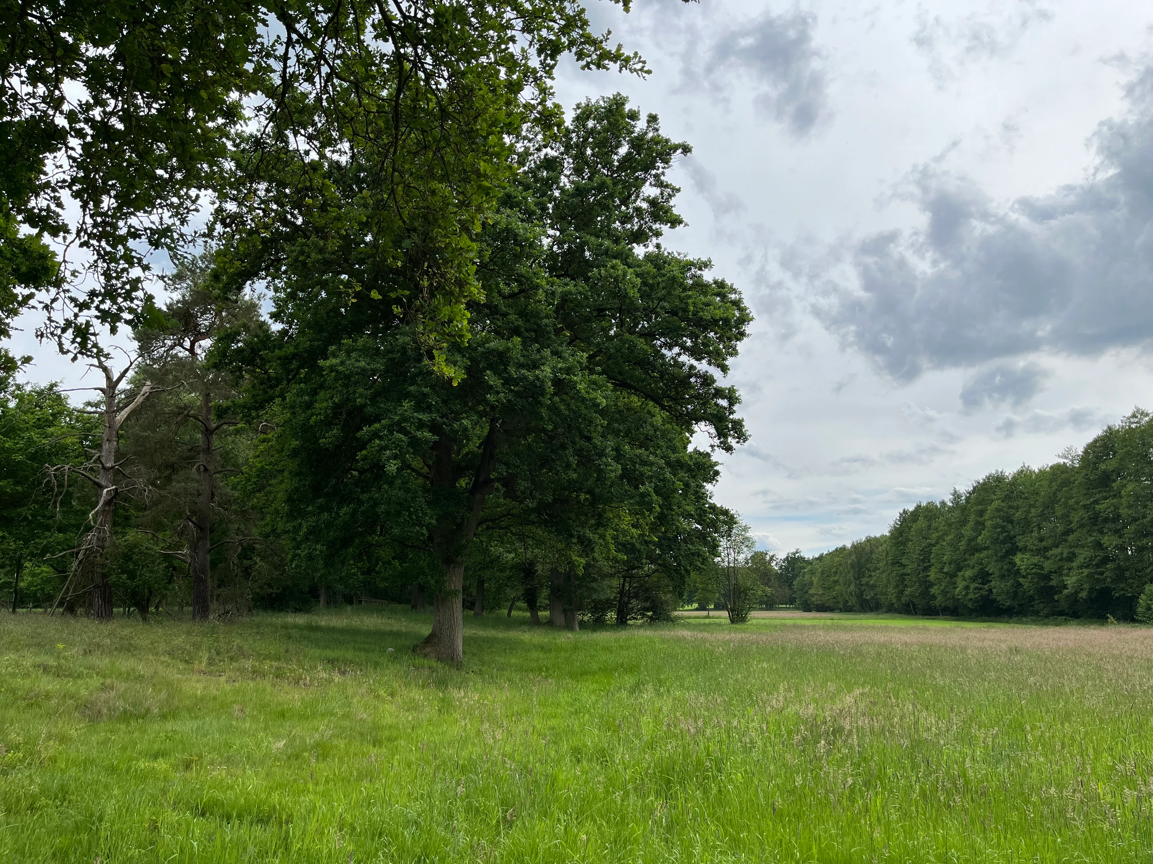
A wide view of a green meadow with scattered deciduous trees and a forest edge under an overcast sky.
A grassy meadow bordered by mature deciduous trees in the Vierenbach nature reserve.

Vierenbach Nature Reserve history and protected-area timeline

The place name associated with the stream is first recorded as an oikonym in 1341, in the form "Campo Virle", and is derived from the Middle Low German word "vīrt", meaning a wild or bushy woodland. This long-standing place-name evidence shows that the stream, its valley, and the surrounding wooded lowland have been recognized as a distinctive local feature in the landscape for centuries, long before formal nature conservation existed.

As a modern protected area, Vierenbach was placed under nature reserve status on 30 December 2004, with the designation NSG LÜ 268. Its establishment was closely linked to the larger conservation framework of the Ilmenau river system, as it was incorporated into the EU FFH area "Ilmenau mit Nebenbächen" and recognized as an important component of the region's Natura 2000 network. Since then, conservation management has been coordinated through the Landkreis Uelzen and the NLWKN, balancing habitat protection with continued limited agricultural use and the presence of the Kreisstraße 42, which crosses part of the reserve near the Bienenbüttel locality of Niendorf.

Vierenbach Nature Reserve landscape and geographic character

Vierenbach occupies a low, flat stretch of the North German plain in Lower Saxony, with elevations varying only between roughly 21 and 39 meters above sea level. The defining feature of the landscape is the narrow valley of the Vierenbach brook itself, together with the adjoining lowland of the Hartgenbeck, framed by the broader Ilmenau catchment and bordered to one side by the engineered waterway of the Elbe-Seitenkanal.

The valley floor is a soft, waterlogged mosaic of wet woodland, fen grassland, reedbeds, sedgy mires, and tall-herb wetland vegetation, all sitting on low moor soils. Along its edges, the terrain rises slightly into drier Geest slopes of sandy, more elevated ground, which carry oak-hornbeam forest and mixed oak woodland. The contrast between these flat, open, damp valley habitats and the higher, drier, wooded Geest slopes gives the small reserve an unusually compressed sense of landscape variety, even though the overall relief remains very gentle.

Vierenbach Nature Reserve ecosystems, habitats, and plant life

Ecologically, Vierenbach is overwhelmingly a wet-landscape reserve, defined by the interaction between a shaded lowland stream and the wetland habitats that line its course. The brook corridor is lined by alder and ash swamp forest, which shade the water and contribute to the cool, near-natural conditions that the reserve is intended to protect.

Beyond the immediate stream-side forests, the wet lowland broadens into birch moor woodland and open wet grassland developed on low moor soils, interspersed with patches of wet scrub, reedbeds, and sedge communities. Tall-herb fen vegetation adds further structural diversity to the valley floor. At the margins, the wet system meets drier Geest slopes with oak-hornbeam and mixed oak forests, producing a sharp but ecologically valuable transition from mire and swamp forest to acid sandy woodland within a very short distance.

Through its inclusion in the FFH area "Ilmenau mit Nebenbächen", the reserve contributes to the broader conservation of the Ilmenau stream system, protecting habitats that depend on natural flow patterns, shaded water, and undisturbed wetland soils.

Vierenbach Nature Reserve wildlife and species highlights

The wildlife interest of Vierenbach centers on species that depend on small, shaded, near-natural lowland streams and their immediate wetland surroundings. The reserve is explicitly managed to protect the brook and its margins as habitat for the Eurasian otter, the bullhead (a small freshwater fish typical of clean, stony brooks), and the brook lamprey, an ancient jawless fish that requires clean gravelly stream beds for its larval stage.

Beyond these headline species, the mosaic of swamp forest, wet grassland, reedbeds, and mixed oak woodland at the margins provides habitat for a wide range of moisture-loving plants and animals typical of north German wetland complexes. Open wet areas support wetland birds, invertebrates, and amphibians associated with reed and sedge communities, while the wet and dry woodland transitions offer nesting and shelter for woodland species. Wild food plots (Wildäcker) have been established in several places inside the reserve to support game species and add localized structural diversity.

Vierenbach Nature Reserve conservation status and protection priorities

Vierenbach is designated as an IUCN Category IV Habitat/Species Management Area, reflecting its role in actively conserving specific habitats and species rather than setting aside untouched wilderness. The primary conservation goal is the preservation and development of near-natural, mostly shaded lowland streams, which serve as refuges for sensitive species such as the Eurasian otter, the bullhead, and the brook lamprey.

A parallel goal is the protection of the surrounding near-natural deciduous forests and the broader complex of wetland habitats that support moisture-loving plants and animals. Through its inclusion in the FFH area "Ilmenau mit Nebenbächen", the reserve is bound into the EU Natura 2000 network, which strengthens its role in maintaining ecological connectivity and stream continuity along the Ilmenau system. Conservation management is shared between the Landkreis Uelzen, which acts as the responsible lower nature conservation authority, and the NLWKN at the state level, balancing strict habitat protection with limited traditional agricultural use of parts of the area.

Vierenbach Nature Reserve cultural meaning and human context

The reserve has a quiet but real cultural dimension rooted in landscape and land use. The name of the stream, and by extension the reserve, was first recorded in 1341 as "Campo Virle", and is derived from the Middle Low German word "vīrt", meaning wild or bushy woodland. This etymology preserves an old regional understanding of the area as a place of tangled, natural woodland, suggesting that locals have long recognized the unusual wild character of this particular stream valley.

Today, the reserve continues to host traditional land uses within its boundaries. Some areas are still managed agriculturally, including meadow use on the wet grassland, and several wild food plots (Wildäcker) have been established to support woodland game. The Kreisstraße 42 crosses part of the reserve near the Bienenbüttel locality of Niendorf, and a permitted footpath runs along the western edge, embedding the protected landscape within the everyday rural life of Bienenbüttel.

Top sights and standout views in Vierenbach Nature Reserve

Vierenbach stands out for the tight concentration of lowland stream, swamp forest, and fen habitats within a compact area, and for the unusually clear transition from wet valley floor to dry Geest slopes within just a few hundred meters. Its inclusion in the EU FFH area "Ilmenau mit Nebenbächen" anchors it within a wider conservation network along the Ilmenau.

The reserve is also notable for combining relatively strict habitat protection with active, ongoing land management, including continuing agricultural use and even a public road crossing part of the area. This makes it an interesting example of how small, ecologically rich reserves can be maintained alongside traditional rural land use in the North German plain.

Best time to visit Vierenbach Nature Reserve

Vierenbach is a quiet, low-relief wetland reserve best appreciated in the warmer months when wetland vegetation is fully developed. Late spring and early summer bring the most active period for wetland plants, reeds, and sedge communities, while the leafy canopy of the alder and ash swamp forests is at its densest. Early morning visits during this period are usually best for observing wetland birds and other moisture-loving wildlife.

Autumn can also be attractive, as the mixed oak forests on the Geest slopes along the edges of the reserve take on color, contrasting with the still-green wet valley floor. In winter, much of the wet grassland and reed area becomes quieter and structurally more open, making the broader layout of the stream valley easier to read, though some paths may be waterlogged. Visitors should generally treat any visit as a low-key, weather-dependent walk rather than a fixed-season activity, and should respect the fact that only a designated path on the western edge is open to public entry.

Monthly climate preview

Long-term representative point measurements for temperature and precipitation rhythm

Vierenbach Climate Normals and Measured Monthly Weather Patterns

Vierenbach records long-term monthly climate normals spanning from sub-zero winter lows to warm summer maximums alongside consistent daily precipitation rates. Examining the full twelve-month profile reveals detailed baseline patterns for average temperature and monthly precipitation across the landscape.
Annual mean9 °C
0 °C19 °C
Jan
Feb
Mar
Apr
May13°
Jun16°
Jul19°
Aug18°
Sep14°
Oct
Nov
Dec
Warmest month
July

18.5 °C

Coolest month
January

0.2 °C

Wettest month
July

2.5 mm/day

Driest month
April

1.3 mm/day

Park location guide

Geography guide, regional context, and park location map for Vierenbach Nature Reserve

Vierenbach Nature Reserve park geography, regions, and map view in Germany

Understand where Vierenbach Nature Reserve sits in Germany through a broader geographic reading of the surrounding landscape, nearby location context, and its mapped position within the national park landscape.

How Vierenbach Nature Reserve fits into Germany

Germany is a federal republic in Western and Central Europe with a population of over 83 million across sixteen constituent states. It is Europe's largest economy by nominal GDP and a major global exporter and importer. The capital is Berlin, and the country borders Denmark, Poland, Czech Republic, Austria, Switzerland, France, Luxembourg, Belgium, and the Netherlands.

Wider geography shaping Vierenbach Nature Reserve in Germany

Germany is located in Western and Central Europe, spanning 357,022 km². It borders Denmark to the north, Poland and the Czech Republic to the east, Austria and Switzerland to the south, and France, Luxembourg, Belgium, and the Netherlands to the west. The country has coastlines on the Baltic Sea and North Sea to the north, with the Alps located in the southern region.

Map view of Vierenbach Nature Reserve

Use this park location map to pinpoint Vierenbach Nature Reserve in Germany, understand its exact geographic position, and read its mapped placement within the surrounding landscape more clearly.

Pigeon | © OpenStreetMap contributors

Location context for Vierenbach Nature Reserve

Lower SaxonyUelzen District

Explore photographic documentation of swamp forests, lowland streams, and terrain gradients.

Vierenbach Photos and Landscape Scenery: Visualizing Protected Valley Habitats

Visual records capture the waterlogged valley floor, swamp woodlands, and dry Geest slopes that define the protected landscape. Examining these field photographs reveals the micro-topography and wetland habitats sustaining local stream ecology.

A wide view of a green meadow with scattered deciduous trees and a forest edge under an overcast sky.

Park atlas

Compare surrounding wetland corridors and regional protected landscapes across the Ilmenau catchment.

Explore Protected Areas and Parks Near Vierenbach in the Lower Saxony Plain

Browse adjacent lowland reserves and connected brook habitats situated throughout the surrounding northern German plain. Continuing geographic comparison reveals broader regional conservation patterns beyond Vierenbach.
Nature reserveLandkreis Uelzen
About 14 km away#1 closest

Southeast

Vogelfreistätte Jastorfer See Nature Reserve in Landkreis Uelzen, Germany

Wetland habitat and river valley protected area

Vogelfreistätte Jastorfer See is a protected wetland landscape located in the Ilmenau valley. This nature reserve, spanning 16.5 hectares, preserves a mosaic of open water and alder swamp forest that sustains diverse bird populations including kingfishers and marsh harriers. It serves as a regionally significant conservation site, embedded within the broader Ilmenautal protected corridor in northern Germany.

Area
0.165 km²
Established
1977
IUCN
IV
Relief
Lowland
Nature reserveLower Saxony
About 15 km away#2 closest

North

Streitmoor Nature Reserve Geography and Mapped Protected Land in Lower Saxony

A study in compact bog and wetland succession

Streitmoor provides a detailed look at a terrestrialized pond moor within the Lüneburg district. The site contains a layered sequence of peat mosses, cottongrass, and woodland, mapping the natural transition between open bog basins and dry forest margins in northwestern Germany.

Area
0.13 km²
Established
1972
IUCN
IV
Relief
Lowland
Nature reserveLandkreis Uelzen
About 16 km away#3 closest

Southwest

Wettenbosteler Moor Protected Area: Geographic Overview and Mapped Landscape Features

A resilient raised bog remnant in the Landkreis Uelzen heath forest

Spanning roughly thirteen hectares, Wettenbosteler Moor preserves a rare spring-fed bog habitat characterized by peat-forming vegetation and pine forest borders. This nature reserve offers deep insights into the drainage networks and lowland terrain of the Lüneburg Heath, mapping the transition between upland forest and valley mire.

Area
0.128 km²
Established
1977
IUCN
IV
Relief
Lowland
Nature reserveLower Saxony
About 21 km away#4 closest

Northwest

Wittsaal Nature Reserve: Mapped Wetland Geography and Protected Landscape in Lower Saxony

A rare mosaic of moor ponds and swamp woodland

Wittsaal is a specialized nature reserve in the Lüneburg region of Lower Saxony, Germany. The area protects a peat-cut moor pond currently undergoing natural silting, surrounded by willow-dominated swamp woodland, reedbeds, and sedge marshes. This compact site provides a critical, quiet refuge for wetland ecology within a wider landscape of agricultural fields and transitional glacial terrain.

Area
0.13 km²
Established
1985
IUCN
IV
Relief
Lowland
Nature reserveLandkreis Heidekreis
About 32 km away#5 closest

Southwest

Tal der Kleinen Örtze Nature Reserve: Geographic Atlas and Protected Area Context

Stream valley restoration in the Lüneburg Heath region

An essential look at the Tal der Kleinen Örtze nature reserve, which encompasses restored brook courses and floodplain woodland in Lower Saxony. This protected area serves as a significant example of hydrological recovery and habitat transition, ranging from alder forests to heathland remnants along the valley margins within the broader Heidekreis geography.

Area
4.5 km²
Established
1993
IUCN
IV
Relief
Lowland
Nature reserveHamburg
About 34 km away#6 closest

Northwest

Zollenspieker Nature Reserve: Geographic Overview and Protected Riverine Landscapes

Tidal Elbe floodplain and inland brack wetland ecology

Located in the Hamburg borough of Bergedorf, Zollenspieker protects a significant stretch of the tidal Elbe. This nature reserve contains approximately 80 hectares of diverse terrain, from freshwater mudflats exposed at low tide to sheltered oak-dominated forests and old brack wetlands known as Carlsbrack and Riepenburger Brack.

Area
0.8 km²
Established
1988
IUCN
IV
Relief
Lowland
A horizontal watercolor painting depicting a rolling heathland landscape with purple heather, evergreen trees, and a central water feature under a soft sky.
Protected landscapeLower Saxony
About 37 km away#7 closest

West

Naturpark Lüneburger Heide: Protected Landscape Map and Regional Geography

An expansive cultural landscape in northern Lower Saxony

Spanning over 1,000 square kilometers, Naturpark Lüneburger Heide preserves the largest contiguous inland heathlands in Central Europe. Use this atlas resource to understand the park's glacial terrain, including karst sinkholes and natural springs, as well as its status as a model region for sustainable conservation and traditional land management practices.

Area
1,097.85 km²
Established
1922
IUCN
V
Relief
Lowland
Nature reserveLower Saxony
About 38 km away#8 closest

Northwest

Stemmbruch Nature Reserve: Protected Lowland Bog Geography in Lower Saxony, Germany

A resilient moorland habitat near the Seeve floodplain

Stemmbruch serves as a vital nature reserve in the Harburg district, protecting a rare hanging spring bog system. This compact protected area features a mosaic of bog pools, heath, and swamp woodland, demonstrating the complex hydrologic connectivity between the sandy geest ridge and the surrounding northern German lowland plains.

Area
0.56 km²
Established
1989
IUCN
IV
Relief
Lowland

Common questions about visiting, size, designation, and location context for Vierenbach Nature Reserve

Vierenbach Nature Reserve FAQs for park facts, access, geography, and protected area context

Find quick answers about Vierenbach Nature Reserve, including protected-area facts, park geography, trail and visitor context, and how the park fits into its surrounding country and regional landscape.
MoriAtlas Explorer

Continue Your Protected Areas Search Across the Global Atlas

Deepen your exploration by continuing the structured search for national parks and protected areas worldwide. Utilize the comprehensive filtering capabilities to compare different conservation landscapes and refine your understanding of global park geography. Discover more about the distribution and characteristics of protected natural areas.

Global natural geography