Mori Atlas logo
Nature reserveVogelschutzgebiet Arsten-Habenhausen

A historic nature reserve preserving floodplain woodland and reedbed habitats along the Weser river

Vogelschutzgebiet Arsten-Habenhausen: Exploring the Protected River Floodplain Landscapes of Bremen

Vogelschutzgebiet Arsten-Habenhausen represents a protected riverine landscape situated along the left bank of the Weser within Bremen, Germany. This compact nature reserve features a distinct floodplain habitat composition, including dense woodland, expansive reedbeds, and tall herb communities that thrive outside the dike line. Designated as a protected area since 1950, the site serves as a vital example of managed floodplain geography in an urban setting.

floodplain woodlandWeser floodplainreedbedswetland reserveurban nature reservesmall protected area

Vogelschutzgebiet Arsten-Habenhausen

Nature reserve

Park overview

Structured park overview, official facts, and landscape profile for Vogelschutzgebiet Arsten-Habenhausen

Vogelschutzgebiet Arsten-Habenhausen park facts, protected area profile, and essential visitor context

Review the core facts for Vogelschutzgebiet Arsten-Habenhausen, including designation, size, terrain, visitor scale, habitats, and operating context in one park-focused overview.

About Vogelschutzgebiet Arsten-Habenhausen

Vogelschutzgebiet Arsten-Habenhausen is one of the smallest protected natural areas in Bremen but also one of the oldest. The reserve lies in the Habenhausen district, on the left bank of the River Weser, a short distance upstream of the Bremer Weserwehr, the large weir that regulates shipping on the lower Weser. Because the site is positioned outside the dike line, it lies within the active floodplain of the river and remains connected to the natural hydrology of the Weser.

The vegetation of the reserve reflects this floodplain setting. Floodplain woodland, reedbeds, and tall herb communities together create a layered mosaic of habitats within a compact footprint. Although the reserve is tiny by national standards, the combination of woody, marshy, and herbaceous vegetation provides refuge for songbirds and amphibians typical of lowland river landscapes in northern Germany.

Administratively, the area has been recorded under nature reserve number one in Bremen's register and has been formally protected since 12 December 1950, giving the site more than seven decades of continuous protection. The Senator for Environment, Climate and Science of the Free Hanseatic City of Bremen serves as the responsible authority. Within Bremen's broader network of nature reserves, Arsten-Habenhausen stands as a small but historically important example of how even very small floodplain fragments can be set aside for long-term habitat and species protection within a major urban region.

Quick facts and research context for Vogelschutzgebiet Arsten-Habenhausen

Vogelschutzgebiet Arsten-Habenhausen is a nature reserve in Bremen, Germany, located on the left bank of the Weser upstream of the Bremer Weserwehr and outside the dike line. It covers about one hectare and is classified under IUCN Category IV as a Habitat/Species Management Area. The reserve has been protected since 12 December 1950 and is the first entry in Bremen's register of nature reserves.

Protection and recognition

Examine terrestrial boundary parameters and formal conservation entries for Vogelschutzgebiet Arsten-Habenhausen.

Vogelschutzgebiet Arsten-Habenhausen Protection Status and Designated Area Record

Vogelschutzgebiet Arsten-Habenhausen maintains a documented terrestrial protection scope within the global protected area registry. Official database records outline the established designation framework without supplementary international recognition sources.

Protection details

Protection scope
Terrestrial
Transboundary protection
No
WDPA ID
82817
Park context

Deeper park guide and search-rich context for Vogelschutzgebiet Arsten-Habenhausen

Vogelschutzgebiet Arsten-Habenhausen history, landscape, wildlife, and travel context

Explore Vogelschutzgebiet Arsten-Habenhausen through its history, landscape character, ecosystems, wildlife, conservation priorities, cultural context, and seasonal travel timing in a structured park guide built for atlas discovery and search intent.

Why Vogelschutzgebiet Arsten-Habenhausen stands out

The reserve is best known as a compact example of a traditional river floodplain habitat inside the Bremen city boundary, preserving floodplain woodland, reedbeds, and tall herb vegetation along the Weser. Its long-standing protected status since 1950 also gives it historical significance as one of Bremen's earliest designated nature reserves.
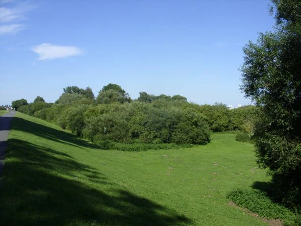
A wide view of a grassy meadow sloping down from an embankment toward dense green trees and shrubs under a clear blue sky.
A view of the green landscape and alluvial vegetation within the Vogelschutzgebiet Arsten-Habenhausen nature reserve.

Vogelschutzgebiet Arsten-Habenhausen history and protected-area timeline

The reserve's history centers on its status as one of Bremen's earliest formal nature protections. It has been under nature protection since 12 December 1950, and it is recorded as protected area number one in the nature reserve register of the Free Hanseatic City of Bremen. The responsible authority is the Senator for Environment, Climate and Science of Bremen, which continues to administer the site as part of the city's wider portfolio of small but ecologically meaningful reserves.

Vogelschutzgebiet Arsten-Habenhausen landscape and geographic character

The landscape of Vogelschutzgebiet Arsten-Habenhausen is shaped entirely by its position along the River Weser. The site lies roughly two kilometers upstream of the Bremer Weserwehr, on the left bank of the river, outside the dike line. As a result, the area belongs to the active floodplain rather than the protected polder landscape behind the dike.

Within this narrow footprint, three landscape elements stand out. Floodplain woodland, or Auwald, provides a woody canopy along the riverbank. Reedbeds occupy the wetter margins of the woodland, and tall herb communities fill the more open transitional zones. Together these features create a layered, semi-natural riverscape that contrasts with the heavily engineered Weser channel further downstream.

Vogelschutzgebiet Arsten-Habenhausen ecosystems, habitats, and plant life

The reserve's natural character is defined by classic lower Weser floodplain ecosystems. Floodplain woodland, reedbeds, and tall herb communities together form a mosaic of habitats that is characteristic of lowland river floodplains in northwestern Germany. This combination of wooded, marshy, and herbaceous vegetation produces the conditions that support a typical assemblage of floodplain species.

Because the site sits outside the dike line and remains linked to natural river dynamics, periodic flooding helps maintain the open wetland communities. The reserve thus functions as a small living example of a floodplain habitat complex, despite its very limited size of about one hectare.

Vogelschutzgebiet Arsten-Habenhausen wildlife and species highlights

The reserve is documented as habitat for songbirds and amphibians, both of which are characteristic groups in floodplain woodland and reedbed environments. The presence of tall herb vegetation, reedbeds, and Auwald creates nesting and shelter opportunities for various songbird species, while the wetter reed-dominated zones offer breeding and foraging habitat for amphibians typical of the lower Weser floodplain.

Although the very small size of the area limits the total wildlife population it can support, the diversity of habitats packed into the site allows several different ecological groups to coexist within a single compact reserve.

Vogelschutzgebiet Arsten-Habenhausen conservation status and protection priorities

The conservation significance of Vogelschutzgebiet Arsten-Habenhausen lies in its long, continuous protection history and its role as a floodplain habitat refuge within an urban state. Designated on 12 December 1950, it predates many modern German nature reserves and is recorded as protected area number one in Bremen's register. Under the IUCN classification system it is listed as a Category IV Habitat/Species Management Area.

By preserving a patch of floodplain woodland, reedbeds, and tall herb vegetation along the Weser, the reserve helps maintain habitat connectivity and ecological functions along the river that would otherwise be lost to urban and industrial pressures. Its small size makes it more of a habitat fragment than a landscape-level reserve, but it is an important piece of Bremen's protected-area network.

Vogelschutzgebiet Arsten-Habenhausen cultural meaning and human context

Culturally, the reserve reflects Bremen's tradition of formally recognizing even very small natural areas as part of the city's identity and heritage. Its location in Habenhausen, a district closely associated with the Weser floodplain, ties the site to the long-standing relationship between Bremen communities and the River Weser. The fact that Arsten-Habenhausen was protected as early as 1950 demonstrates an early municipal commitment to preserving riverside habitats within the city boundary.

Top sights and standout views in Vogelschutzgebiet Arsten-Habenhausen

Vogelschutzgebiet Arsten-Habenhausen is notable for being among the oldest and very smallest nature reserves in Bremen, set along the left bank of the Weser outside the dike line. Its mix of floodplain woodland, reedbeds, and tall herb vegetation makes it a textbook example of a compact floodplain habitat complex in a fully urban setting.

Best time to visit Vogelschutzgebiet Arsten-Habenhausen

Like most floodplain reserves in northwestern Germany, Arsten-Habenhausen is best appreciated in spring and early summer, when hedgerows and herb communities are in active growth and songbird activity is at its peak. Wetland conditions along the Weser are more visible after periods of rain or seasonal high water, when reedbeds and amphibian habitats become more dynamic. Winter visits offer a quieter atmosphere and reveal the structural character of the floodplain woodland once leaves have fallen.

Monthly climate preview

Long-term representative point measurements of annual temperature and precipitation rhythm

Vogelschutzgebiet Arsten-Habenhausen Climate Normals and Weather by Month

Historical climatology records outline the measured monthly temperature range and daily precipitation averages for Vogelschutzgebiet Arsten-Habenhausen from 1991 to 2020. Reviewing the complete twelve-month profile provides deeper analytical context for understanding long-term environmental patterns across the protected terrain.
Annual mean9 °C
1 °C18 °C
Jan
Feb
Mar
Apr
May13°
Jun16°
Jul18°
Aug18°
Sep14°
Oct10°
Nov
Dec
Warmest month
July

18 °C

Coolest month
January

1 °C

Wettest month
July

2.5 mm/day

Driest month
April

1.4 mm/day

Park location guide

Geography guide, regional context, and park location map for Vogelschutzgebiet Arsten-Habenhausen

Vogelschutzgebiet Arsten-Habenhausen park geography, regions, and map view in Germany

Understand where Vogelschutzgebiet Arsten-Habenhausen sits in Germany through a broader geographic reading of the surrounding landscape, nearby location context, and its mapped position within the national park landscape.

How Vogelschutzgebiet Arsten-Habenhausen fits into Germany

Germany is a federal republic in Western and Central Europe with a population of over 83 million across sixteen constituent states. It is Europe's largest economy by nominal GDP and a major global exporter and importer. The capital is Berlin, and the country borders Denmark, Poland, Czech Republic, Austria, Switzerland, France, Luxembourg, Belgium, and the Netherlands.

Wider geography shaping Vogelschutzgebiet Arsten-Habenhausen in Germany

Germany is located in Western and Central Europe, spanning 357,022 km². It borders Denmark to the north, Poland and the Czech Republic to the east, Austria and Switzerland to the south, and France, Luxembourg, Belgium, and the Netherlands to the west. The country has coastlines on the Baltic Sea and North Sea to the north, with the Alps located in the southern region.

Map view of Vogelschutzgebiet Arsten-Habenhausen

Use this park location map to pinpoint Vogelschutzgebiet Arsten-Habenhausen in Germany, understand its exact geographic position, and read its mapped placement within the surrounding landscape more clearly.

Pigeon | © OpenStreetMap contributors

Location context for Vogelschutzgebiet Arsten-Habenhausen

Bremen

Explore visual records of floodplain woodland, reedbeds, and wetland habitats along the River Weser.

Vogelschutzgebiet Arsten-Habenhausen Photos and River Floodplain Scenery

Visual documentation captures the protected terrain, riverine vegetation, and natural habitats found within Vogelschutzgebiet Arsten-Habenhausen. Examining field photography reveals the distinct environmental character of this compact urban floodplain reserve along the Weser.

A wide view of a grassy meadow sloping down from an embankment toward dense green trees and shrubs under a clear blue sky.

Park atlas

Compare surrounding river floodplains and related nature reserves across the region.

Parks Near Vogelschutzgebiet Arsten-Habenhausen and Regional Protected Areas

Browsing other protected areas near Vogelschutzgebiet Arsten-Habenhausen reveals how local riverine habitats connect across the lower Weser floodplain. Examining adjacent reserves provides valuable geographic context for urban wetland conservation and regional park distribution.
Protected landscapeBremen
About 4.3 km away#1 closest

East

Mahndorfer Düne: A Protected Inland Dune Landscape in the City of Bremen

Geological remnants and ecological layering in Northwest Germany.

Mahndorfer Düne is a distinct protected landscape in Bremen, Germany, functioning as one of the final surviving inland dune relics from the Ice Age. The 2.7 hectare area maps a layered transition of sandy soil, dry heathland, and birch-oak woodland, offering an important look at regional post-glacial geology and conservation within a dense urban setting.

Area
0.027 km²
Established
1985
Relief
Lowland
Climate
Temperate
Protected landscapeBremen
About 5 km away#2 closest

Southeast

Mahndorfer Marsch Protected Landscape: Weser River Floodplain and Wetland Atlas

A river-driven marshland corridor in Bremen, Germany

The Mahndorfer Marsch is a protected landscape characterized by its classic Weser floodplain terrain, featuring a network of meadows, channels, and water bodies. Spanning the boundary between Bremen and Lower Saxony, this area provides an essential refuge for migratory bird populations. Understanding the marshland topography offers insight into the historical flood dynamics and environmental preservation of the lower Weser valley.

Area
15.36 km²
Established
2015
IUCN
V
Watercolor painting of a wide, rolling landscape with green trees, golden fields, and soft hills in the background.
Protected areaGermany
About 6.4 km away#3 closest

East

Krietes Wald (Im Holze) Protected Area: Landscape and Geographic Atlas Summary

A critical urban forest node in the Bremen region of Germany.

Krietes Wald (Im Holze) serves as a significant nature reserve characterized by its mature beech and oak-hornbeam woodland. Spanning a narrow, protected corridor in eastern Bremen, the site provides dense habitat value within an industrial landscape. It stands as a regional reference for saproxylic insect conservation and structural forest development within the federal republic of Germany.

Area
0.083 km²
Established
2015
Relief
Lowland
Climate
Temperate
A soft, painterly watercolor illustration depicting a winding river through a flat green meadow with rolling hills in the background.
Nature reserveBremen
About 7.3 km away#4 closest

North

Hollerland Nature Reserve: A Protected Cultural Landscape and Wetland in Bremen

Historic marshland terrain with unique saline spring ecosystems

Hollerland is a 293-hectare nature reserve in Bremen, Germany, notable for its well-preserved cultural landscape of wet grasslands and an intricate medieval ditch network. This protected area serves as a critical breeding ground for meadow birds and hosts an ecologically significant inland saline spring, providing a rare habitat for brackish-adapted plant communities deep within the regional landscape.

Area
2.93 km²
Established
1985
IUCN
IV
Relief
Lowland
A watercolor painting showing a serene landscape with calm water, small islands of trees, and rolling hills in the background.
Nature reserveBremen
About 7.9 km away#5 closest

North

Am Stadtwaldsee (Uni-Wildnis) Nature Reserve: Geographic Atlas and Park Map Context

Protected secondary habitat landscape in Bremen, Germany

Located in Bremen, the Am Stadtwaldsee (Uni-Wildnis) nature reserve offers a compelling study of secondary ecological succession. The area features a dense concentration of ponds and wooded ground shaped by historical sand mining. Explore the mapped boundaries of this eleven-hectare refuge to understand its role in urban biodiversity and regional landscape conservation.

Area
0.114 km²
Established
1991
IUCN
IV
Nature reserveBremen
About 8.1 km away#6 closest

North

Kuhgrabensee Nature Reserve: Mapped Geography and Protected Areas in Bremen

An ecologically vital lake and bird sanctuary in Northwest Germany

Kuhgrabensee serves as a prime example of landscape restoration within Bremen, featuring a groundwater-fed lake with notable saline influences. This protected area supports a diverse array of pioneer plants and wildlife across its reed-lined shores and shallow-water habitats, providing a quiet corridor for ecological observation and study in the heart of the local landscape.

Area
0.296 km²
Established
1987
Relief
Lowland
Climate
Temperate
A pale, soft-toned watercolor illustration of a calm river meandering through open, green marshy meadows with distant rolling hills under a soft pink sky.
Nature reserveBremen
About 9.4 km away#7 closest

Northeast

Borgfelder Wümmewiesen: Protected Wetland and Floodplain Geography in Bremen

An expansive 688-hectare nature reserve with river-fed grasslands.

Borgfelder Wümmewiesen offers a look at one of the largest protected nature reserves in the Bremen region. The landscape is characterized by its flat, open terrain and regular water dynamics that frame a rich mosaic of wet meadows, reedbeds, and ponds, providing essential habitat for breeding and migratory bird species along the Wümme river corridor.

Area
6.88 km²
Established
1987
Relief
Lowland
Climate
Temperate
Nature reserveBremen
About 9.4 km away#8 closest

North

Untere Wümme Nature Reserve: Riverine Biodiversity and Protected Tidal Landscapes in Bremen

Protected floodplain geography and tidal river habitats.

This nature reserve protects the meandering lower course of the Wümme river, showcasing one of northern Germany's few freshwater tidal systems. Spanning reedbeds, willow forests, and open mudflats, the reserve forms a vital corridor for migratory fish and waterfowl, reflecting a complex mosaic of protected riverine ecosystems and historic meadow landscapes.

Area
1.485 km²
Established
1991
Relief
Lowland
Climate
Temperate

Common questions about visiting, size, designation, and location context for Vogelschutzgebiet Arsten-Habenhausen

Vogelschutzgebiet Arsten-Habenhausen FAQs for park facts, access, geography, and protected area context

Find quick answers about Vogelschutzgebiet Arsten-Habenhausen, including protected-area facts, park geography, trail and visitor context, and how the park fits into its surrounding country and regional landscape.
MoriAtlas Explorer

Continue Your Protected Areas Search Across the Global Atlas

Deepen your exploration by continuing the structured search for national parks and protected areas worldwide. Utilize the comprehensive filtering capabilities to compare different conservation landscapes and refine your understanding of global park geography. Discover more about the distribution and characteristics of protected natural areas.

Global natural geography