Mori Atlas logo
Natural monumentVrásový soubor v Klokočůvku

Examining folded Culm sedimentary strata and tectonic rock formations in the Moravian-Silesian Region.

Vrásový soubor v Klokočůvku Natural Monument: A Structural Geology and Landscape Atlas

Vrásový soubor v Klokočůvku represents a distinct protected natural monument in the Moravian-Silesian Region, preserving a textbook exposure of folded Carboniferous sedimentary rocks. The site reveals complex structural geology, including upright, inclined, and recumbent folds within the Variscan orogeny context. This atlas entry provides a detailed look at the rock exposures, terrain characteristics, and geological significance of this compact protected area.

geological monumentnatural monumentfolded strataCulm formationVariscan geologystructural geology

Vrásový soubor v Klokočůvku

Natural monument

Park overview

Structured park overview, official facts, and landscape profile for Vrásový soubor v Klokočůvku

Vrásový soubor v Klokočůvku park facts, protected area profile, and essential visitor context

Review the core facts for Vrásový soubor v Klokočůvku, including designation, size, terrain, visitor scale, habitats, and operating context in one park-focused overview.

About Vrásový soubor v Klokočůvku

Vrásový soubor v Klokočůvku is a geological natural monument in the northeastern Czech Republic, situated in the Moravian-Silesian Region near the town of Odry. Despite its very small footprint, the site draws attention because it preserves an unusually complete natural cross-section through folded sedimentary rocks of the Hradec-Kyjovice formation, a unit within the broader Moravian-Silesian Culm sequence.

The Culm refers to a thick succession of Lower Carboniferous, predominantly clastic marine sediments deposited along the southern margin of Laurussia and later deformed during the Variscan orogeny. In the Klokočůvek area, these rocks are exposed at the surface as silty shales, clay-rich slates, and locally fine-grained greywackes arranged in thin-bedded to thin-flaggy layers. The combination of their composition and tectonic history has produced outcrops where folding is exceptionally visible and varied.

The site's most recognizable feature is the Dračí skála, a rock cliff whose name derives from a small cave or recess at its base, traditionally said to be the lair of a dragon. The rock face displays an intense pattern of folding at scales ranging from tens of centimeters to several meters, allowing visitors to read multiple stages and styles of deformation in a single outcrop.

Although the area is too limited to be a traditional landscape destination, it is meaningful for those interested in structural geology, regional tectonic history, and the broader geological heritage of Silesia and northern Moravia. It functions simultaneously as a protected natural site, a field teaching locality, and a piece of regional identity tied to the landscape around Klokočůvek.

Quick facts and research context for Vrásový soubor v Klokočůvku

Vrásový soubor v Klokočůvku is a Czech natural monument (přírodní památka, IUCN Category III) located in the cadastral area of Klokočůvek, a local part of the town of Odry in the Nový Jičín District of the Moravian-Silesian Region. It was declared a protected site on 22 June 1998 by the former Okresní úřad Nový Jičín and is currently administered by the Regional Authority of the Moravian-Silesian Region.

The site protects a natural rock exposure of folded Culm strata and covers a very small area of approximately 1.25 hectares at elevations between roughly 338 and 376 meters above sea level. Its conservation purpose is geological, focused on preserving fold structures and rock types of the Hradec-Kyjovice formation, rather than habitat or scenery.

Park context

Deeper park guide and search-rich context for Vrásový soubor v Klokočůvku

Vrásový soubor v Klokočůvku history, landscape, wildlife, and travel context

Explore Vrásový soubor v Klokočůvku through its history, landscape character, ecosystems, wildlife, conservation priorities, cultural context, and seasonal travel timing in a structured park guide built for atlas discovery and search intent.

Why Vrásový soubor v Klokočůvku stands out

The monument is best known for its exceptionally well-exposed and structurally complex set of rock folds within Culm sedimentary rocks. The dominant landform, the Dračí skála or Dragon Rock, exhibits an unusually wide spectrum of fold styles, including upright, inclined, overturned, recumbent, and plunging folds ranging from decimeters to meters in scale. This variety has made the outcrop a locally notable natural laboratory for studying Variscan-age deformation in the Moravian-Silesian Culm.
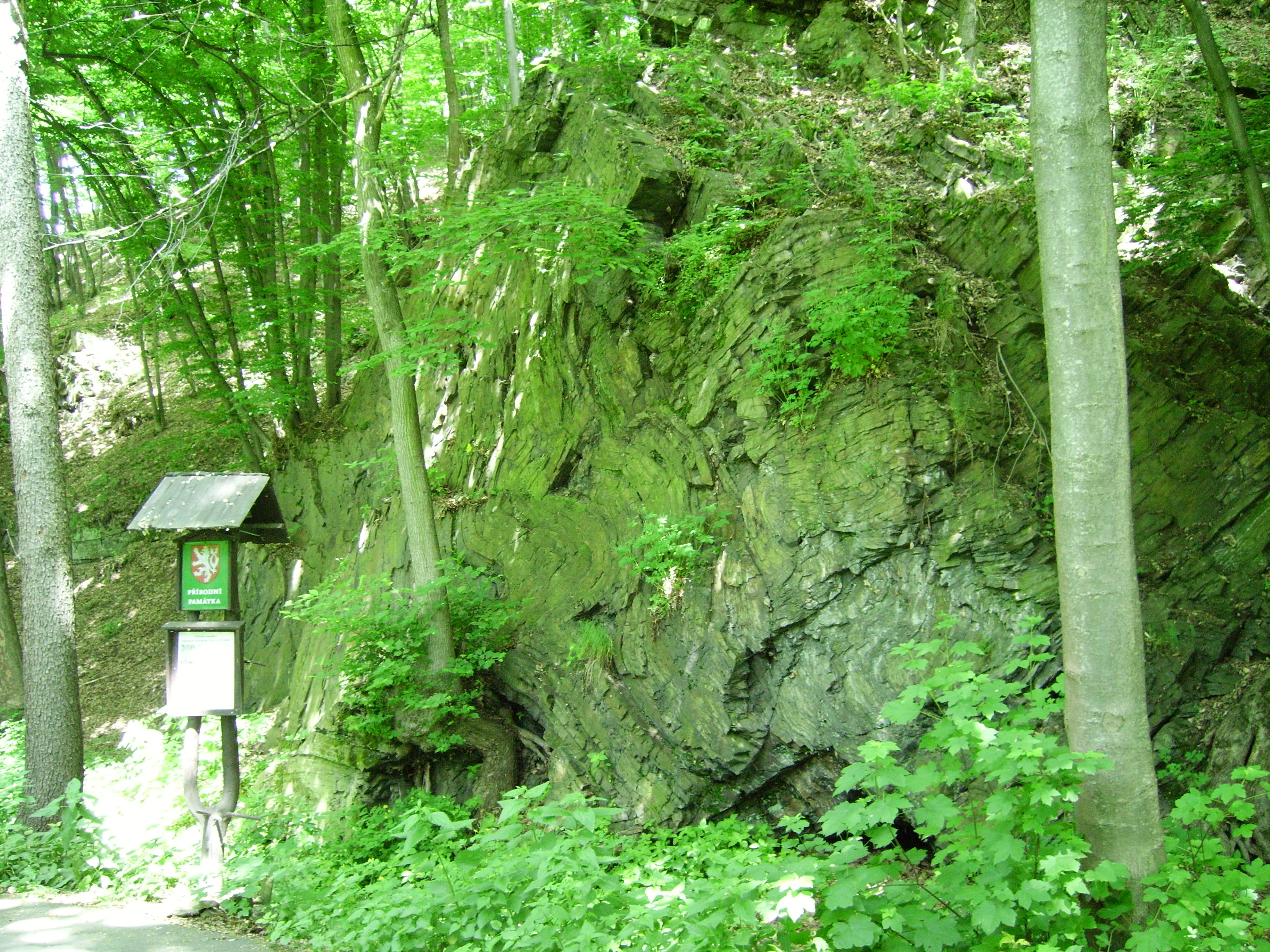
A large, dark rock outcrop with visible geological folding, partially obscured by green trees and forest vegetation, with a park information sign on a post in the foreground.
A prominent geological fold rock formation at the natural monument Vrásový soubor v Klokočůvku.

Vrásový soubor v Klokočůvku history and protected-area timeline

The protected status of Vrásový soubor v Klokočůvku was formally established on 22 June 1998, when the area was declared a natural monument (přírodní památka) by the Okresní úřad Nový Jičín. Its designation reflected long-standing recognition of the outcrop as a scientifically valuable example of Culm-age folding, particularly after broader geological mapping of the Moravian-Silesian Culm during the twentieth century highlighted the Klokočůvek section as unusually instructive.

Following regional administrative reforms, stewardship of the site passed to the Regional Authority of the Moravian-Silesian Region, which continues to manage the monument. The site's recorded identifier in the Czech nature conservation database is 1959. Beyond the formal protection event, the rock itself carries older layers of history: the indigenous folded strata are Carboniferous in age, while local folklore has long associated the small cave at the base of the main cliff with a dragon, giving the site its popular name, Dračí skála.

Vrásový soubor v Klokočůvku landscape and geographic character

The landscape of the protected area is narrow and tightly defined by its underlying geology. The site occupies a hillside position on the edge of Klokočůvek, where erosion has stripped back the surface to expose bedding planes, cleavage surfaces, and folded strata of Culm siltstones, clay slates, and fine greywackes. Within about 1.25 hectares, the terrain shifts from forest-covered slope to exposed rock face.

The dominant visual element is the Dračí skála, a rock cliff whose layered, curved, and recumbent structures give it an unusually sculptural appearance for such a compact outcrop. A small cave-like recess at its base contributes to the cliff's character and explains its folk name. Around the rock the slopes descend into mixed woodland typical of the northern Moravian-Silesian foothills, with elevations ranging from approximately 338 to 376 meters above sea level.

Vrásový soubor v Klokočůvku ecosystems, habitats, and plant life

Vegetation at Vrásový soubor v Klokočůvku reflects its position as a small woodland-and-rock mosaic in the northern Moravian foothills. The exposed rock surfaces support only sparse plant cover, while the surrounding slopes carry mixed deciduous forest typical of the region.

Among the recorded flora, the protected perennial honesty (Lunaria rediviva) is particularly notable, growing in shaded conditions near the cliff base. Yellow wood anemone (Anemone ranunculoides) and Corydalis solida are also documented in the site's undergrowth, contributing a springtime herb layer characteristic of moist, base-rich foothill woodlands in this part of the Czech Republic.

Vrásový soubor v Klokočůvku conservation status and protection priorities

The conservation significance of Vrásový soubor v Klokočůvku lies almost entirely in its geological heritage. As an IUCN Category III natural monument, the site's primary purpose is to protect an intact natural exposure of folded Culm strata that would otherwise be vulnerable to weathering, vegetation overgrowth, or human disturbance.

By safeguarding the Dračí skála and its associated outcrops, the monument preserves a rare opportunity to observe Variscan-age deformation structures at easily accessible outcrop scale in the Moravian-Silesian region. This educational and scientific role complements its protection status, making the site a small but high-value component of the Czech Republic's network of geological protected areas.

Vrásový soubor v Klokočůvku cultural meaning and human context

The cultural identity of the site is closely tied to local folklore and the rural character of Klokočůvek, a small part of the town of Odry in the historic Silesian-Moravian borderlands. The cliff's popular name, Dračí skála (Dragon Rock), comes from legend associating a small cave or shelter at the base of the outcrop with a dragon.

This blend of folk legend and geological curiosity is typical of small Czech natural monuments, where rural traditions and natural heritage reinforce one another. The site also belongs to the broader cultural landscape of the Odry area, a region noted both for its historical connection to Silesia and for its concentration of protected natural sites.

Top sights and standout views in Vrásový soubor v Klokočůvku

The standout feature of Vrásový soubor v Klokočůvku is the compact but textbook-quality exposure of folded Culm strata at the Dračí skála, where upright, inclined, overturned, recumbent, and plunging folds can be observed within a single rock face. The site's value lies less in size than in the clarity and variety of its geological structures.

Best time to visit Vrásový soubor v Klokočůvku

The site can be visited year-round, but spring and early summer are generally the most comfortable seasons for walking the short wooded slopes around the exposure, when foliage is light, the herb layer including Lunaria rediviva, Anemone ranunculoides, and Corydalis solida is visible, and the rock face is easier to observe without heavy vegetation cover. Autumn also offers clear views, while winter shows the structural geology unobstructed by leaves.

Monthly climate preview

Long-term representative point measurements for temperature and monthly precipitation rhythm

Vrásový soubor v Klokočůvku Climate Normals and Annual Temperature Patterns

Representative coordinate measurements outline the long-term annual temperature range and monthly precipitation rhythm recorded for Vrásový soubor v Klokočůvku. Examining the complete twelve-month climatology profile reveals deeper variations in historical temperature and moisture averages.
Annual mean8 °C
-4 °C19 °C
Jan-4°
Feb-2°
Mar
Apr
May13°
Jun17°
Jul19°
Aug19°
Sep14°
Oct
Nov
Dec-2°
Warmest month
July

19.3 °C

Coolest month
January

-3.8 °C

Wettest month
July

2.9 mm/day

Driest month
January

1.3 mm/day

Park location guide

Geography guide, regional context, and park location map for Vrásový soubor v Klokočůvku

Vrásový soubor v Klokočůvku park geography, regions, and map view in Czechia

Understand where Vrásový soubor v Klokočůvku sits in Czechia through a broader geographic reading of the surrounding landscape, nearby location context, and its mapped position within the national park landscape.

How Vrásový soubor v Klokočůvku fits into Czechia

Czech Republic is a landlocked Central European country with a population of approximately 10.9 million people. The nation was established as an independent state on January 1, 1993, following the dissolution of Czechoslovakia. Its capital and largest city is Prague, with other major urban centers including Brno, Ostrava, Plzeň, and Liberec.

Wider geography shaping Vrásový soubor v Klokočůvku in Czechia

The Czech Republic is a landlocked country in Central Europe. It is bordered by Germany to the west, Austria to the south, Poland to the northeast, and Slovakia to the southeast. The landscape is predominantly hilly, with the territory covering 78,871 square kilometers.

Map view of Vrásový soubor v Klokočůvku

Use this park location map to pinpoint Vrásový soubor v Klokočůvku in Czechia, understand its exact geographic position, and read its mapped placement within the surrounding landscape more clearly.

Pigeon | © OpenStreetMap contributors

Location context for Vrásový soubor v Klokočůvku

Moravskoslezský kraj

Visual reference guide to folded Culm strata, Dračí skála, and protected woodland terrain

Vrásový soubor v Klokočůvku Photos, Rock Exposures, and Scenery

Photographic records reveal the complex geological formations and exposed rock layers that define Vrásový soubor v Klokočůvku. Visual documentation allows researchers and visitors to examine intricate fold structures and protected woodland terrain in close detail.

A large, dark rock outcrop with visible geological folding, partially obscured by green trees and forest vegetation, with a park information sign on a post in the foreground.

Park atlas

Compare adjacent geological monuments, protected landscapes, and regional park terrain.

Explore Other Parks Near Vrásový soubor v Klokočůvku and Surrounding Protected Regions

Browse other parks near Vrásový soubor v Klokočůvku to examine related geological formations and surrounding protected landscapes. Expanding the regional park comparison helps place compact natural monuments into a wider geographical and tectonic context.
A horizontal watercolor illustration of a river landscape with lush green banks and rolling purple hills in the background against a white background.
Natural monumentMoravskoslezský kraj
About 17 km away#1 closest

Southeast

Meandry Staré Odry: Geography of a Protected Natural Monument in Moravian-Silesian Region

Historic river meanders and floodplain riparian ecosystems

Meandry Staré Odry represents a vital conservation fragment within the Czech Republic, preserving the original meandering path of the Odra River. This natural monument is defined by quiet oxbow pools, seasonally flooded meadows, and dense riparian forests. Its geographic profile highlights the contrast between historical water dynamics and the surrounding landscape of the Moravskoslezský kraj, providing a precise look at riparian terrain.

Area
0.278 km²
Established
1999
IUCN
IV
Relief
Lowland
Natural monumentOlomouc Region
About 27 km away#2 closest

Southwest

Veselíčko Natural Monument: Geographic Profile of a Czech Protected Area

Concentrated conservation and habitat mapping in the Olomouc Region

Located in the Olomouc District, Veselíčko is a compact natural monument dedicated to specialized habitat protection. This site acts as a key component of the regional conservation network, offering insight into the intersection of cultural heritage and wildlife refuge management in the Czech Republic.

Area
0.001 km²
Established
2013
IUCN
III
Relief
Lowland
Natural monumentMoravskoslezský kraj
About 31 km away#3 closest

Southeast

Váňův kámen: Natural Monument and Jurassic Limestone Landmark in the Moravian-Silesian Region

Geological outcrops and forest terrain in the Sub-Beskydy Hills

Váňův kámen presents a sharp, pyramid-shaped Jurassic limestone formation that breaks the rolling topography of the Sub-Beskydy Hills. This 0.78-hectare protected site preserves vital evidence of prehistoric coral reefs alongside significant archaeological layers and historical markers. Its unique position as a natural, historical, and geological feature makes it a focal point for understanding the diverse landscape composition of the Czech Moravian-Silesian Region.

Area
0.008 km²
Established
1993
IUCN
III
Relief
Upland
A soft watercolor illustration depicting a green, open floodplain with rows of trees under a pale, gentle sky.
Nature reserveMoravskoslezský kraj
About 35 km away#4 closest

East

Polanský les Nature Reserve: Mapped Protected Landscape and Floodplain Geography

A preserved hardwood forest relic in the Ostrava region

Polanský les maintains a critical status as a protected nature reserve, safeguarding a relic hardwood floodplain forest along the Oder River. This area is characterized by its significant botanical diversity, including established snowdrop populations and mature broadleaf woodland. Its location within the Moravskoslezský kraj highlights its role as a dense ecological fragment at the geological boundary between the Bohemian Massif and the Outer Western Carpathians.

Area
0.598 km²
Established
1970
IUCN
IV
Relief
Lowland
Natural monumentMoravskoslezský kraj
About 36 km away#5 closest

Northwest

Uhlířský vrch Natural Monument: Mapping Volcanic Terrain and Heritage in Moravskoslezský kraj

A preserved volcanic cone featuring historic pilgrimage architecture.

Located in the Nízký Jeseník highlands, Uhlířský vrch represents one of the youngest extinct volcanoes in the Czech Republic. The protected area centers on a former tuff quarry revealing basaltic history, while the summit preserves a significant Baroque pilgrimage landscape, including a historic linden avenue and views extending toward the Hrubý Jeseník.

Area
0.035 km²
Established
1966
IUCN
III
Relief
Mountain
Natural monumentMoravskoslezský kraj
About 36 km away#6 closest

Southeast

Velký kámen: A Geological Natural Monument in the Moravskoslezský kraj Landscape

Sandstone cliffs and slope deformation in the western Carpathians.

Velký kámen offers a precise window into the flysch geology of the western Carpathians. The site features a defined sandstone cliff and extensive boulder debris, integrated with a natural forest fragment that showcases the biodiversity and terrain evolution characteristic of the Radhošťská hornatina highlands.

Area
0.036 km²
Established
1999
IUCN
III
Relief
Mountain
A soft watercolor painting depicting a gentle, hazy landscape with rolling hills, scattered patches of trees, and a winding path, rendered in light green, yellow, and peach tones against a white background.
Protected landscapeCzechia
About 37 km away#7 closest

South

Hostýnské vrchy Nature Park: Protected Landscape and Carpathian Foothill Geography

Forested ridge terrain across Zlín and Kroměříž districts

Hostýnské vrchy Nature Park represents a significant protected unit in the eastern Czech Republic, characterized by its deep forested ridges and open meadow clearings. As part of the outer Western Carpathians, the area supports diverse habitats including ancient beech and mixed forest stands alongside rare orchid populations. The landscape provides a clear window into the natural geography of central Moravia, with its intricate network of small watercourses and slopes.

Area
204 km²
Established
1989
Water
Minor water
Season
Year-round
Natural monumentOlomouc Region
About 43 km away#8 closest

Southwest

Vlkoš - statek Natural Monument: Geography and Protected Area Context in the Olomouc Region

Small-scale conservation in the Morava river floodplain

Vlkoš - statek is a significant natural monument comprising a single farmhouse attic that serves as a vital summer refuge for protected bat species. Situated within the flat alluvial terrain of the Olomouc Region, this site highlights the role of anthropogenic structures as key ecological components of the surrounding lowland landscape.

Established
2013
IUCN
III
Relief
Lowland
Climate
Temperate

Common questions about visiting, size, designation, and location context for Vrásový soubor v Klokočůvku

Vrásový soubor v Klokočůvku FAQs for park facts, access, geography, and protected area context

Find quick answers about Vrásový soubor v Klokočůvku, including protected-area facts, park geography, trail and visitor context, and how the park fits into its surrounding country and regional landscape.
MoriAtlas Explorer

Continue Your Protected Areas Search Across the Global Atlas

Deepen your exploration by continuing the structured search for national parks and protected areas worldwide. Utilize the comprehensive filtering capabilities to compare different conservation landscapes and refine your understanding of global park geography. Discover more about the distribution and characteristics of protected natural areas.

Global natural geography