
Mori Atlas logo
Natural monumentVrbenská tůň

A critical lowland aquatic habitat and oxbow pond system within the České Budějovice Basin landscape.

Vrbenská tůň Natural Monument: Mapping Protected Wetland Landscapes in the Jihočeský kraj Region

Vrbenská tůň represents a vital fragment of the lowland floodplain ecology preserved in the South Bohemian region of the Czech Republic. As a designated natural monument, this site protects a complex of shallow oxbow-style ponds that serve as an important refuge for threatened amphibian populations and characteristic wetland vegetation. The geography of the site highlights the ecological contrast between remnant aquatic systems and the surrounding agricultural plains of the České Budějovice Basin.

wetlandlowland pondsmall protected areaIUCN Category IIInatural monumentamphibian habitat
A flat-style digital illustration of a scenic valley featuring a small pond in the foreground, a winding river, and a waterfall cascading down a cliff face in the background.

Vrbenská tůň

Natural monument

Park overview

Structured park overview, official facts, and landscape profile for Vrbenská tůň

Vrbenská tůň park facts, protected area profile, and essential visitor context

Review the core facts for Vrbenská tůň, including designation, size, terrain, visitor scale, habitats, and operating context in one park-focused overview.

About Vrbenská tůň

Vrbenská tůň is a modest but ecologically meaningful protected wetland in the South Bohemian Region of the Czech Republic. Situated in the broad, flat agricultural landscape of the Českobudějovická pánev, it preserves a cluster of still-water pools (tůně) of the kind that historically characterized this part of Bohemia. The site lies about one kilometer south of the small settlement of Bavorovice, and its identity is tied to the older village of České Vrbné, long since absorbed into the expanding city of České Budějovice.

The natural monument status of the site, designated within the Czech system of small-scale nature protection, reflects long-term recognition of its aquatic and wetland biodiversity value. Its protected designation records backwater- and pond-type flora typical of lowland river margins and lists a set of endangered plants and amphibians as the basis for protection. The surrounding Českobudějovice Basin has been heavily modified by centuries of farming, fishpond construction, and settlement expansion, and small preserved wetlands like Vrbenská tůň represent surviving fragments of the more diverse wetland mosaic that once existed across this region.

The site's character is shaped as much by its history of human intervention as by its natural features. Before 1969, the pools were embedded in a network of wet meadows. These meadows were subsequently converted to arable fields, altering local hydrology and ecological conditions. Restoration work in 1989, including sediment removal (odbahnění) and the introduction of water from the Dehtářský potok stream, helped stabilize the basin's water regime. Today, the protected area and its broader buffer zone serve as a small but important refuge for native pond vegetation and amphibian breeding habitat in an otherwise intensively used agricultural landscape.

Quick facts and research context for Vrbenská tůň

Vrbenská tůň is classified as a přírodní památka (natural monument) under Czech nature conservation law, corresponding to IUCN Category III. The protected area was declared on 22 February 1974 by the Ministry of Culture of the then Czechoslovak Republic, with an earlier related designation listed for 18 October 1974 in the infobox data. It sits at an elevation of 377 meters above sea level within the Českobudějovická pánev basin system, south of Bavorovice and tied historically to the village of České Vrbné near České Budějovice.

The site covers roughly 0.88 hectares, with a surrounding protective buffer zone of about 4.6 hectares. The name 'tůň' refers to a still-water pool or backwater, reflecting the site's character as a lowland aquatic habitat.

Protection and recognition

Documented protection records and management context for Vrbenská tůň

Vrbenská tůň Protection Status and Designated Terrestrial Conservation Scope

Terrestrial protection status and designation history outline the documented management scope of Vrbenská tůň. Structured conservation facts provide verified reference data regarding international recognition sources and administrative context.

Protection details

Protection scope
Terrestrial
Transboundary protection
No
Buffer area
0.05 km²
Park context

Deeper park guide and search-rich context for Vrbenská tůň

Vrbenská tůň history, landscape, wildlife, and travel context

Explore Vrbenská tůň through its history, landscape character, ecosystems, wildlife, conservation priorities, cultural context, and seasonal travel timing in a structured park guide built for atlas discovery and search intent.

Why Vrbenská tůň stands out

Vrbenská tůň is best known as a small lowland pond complex that once hosted one of the few regional populations of řezan pilolistý (Stratiotes aloides), a distinctive water-plant of slow-moving oxbow and backwater habitats. Although that species has since disappeared from the site, the monument remains notable for its surviving assemblage of endangered aquatic plants and, especially, for its rich amphibian fauna, which includes species such as the fire-bellied toad, spadefoot toad, and European tree frog. Its broader significance lies in its representation of a now-fragmented landscape of meadows, pools, and backwaters in the České Budějovice Basin. The site's history of dredging, hydrological restoration in 1989, and connection to water from the Dehtářský potok stream illustrate the kind of management interventions small Czech wetland monuments receive to maintain their ecological value.
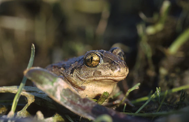
A close up view of a common spadefoot toad with large, prominent eyes nestled in green vegetation.
A common spadefoot toad, a species found in the wetland habitat of Vrbenská tůň.

Vrbenská tůň history and protected-area timeline

Vrbenská tůň received formal protected status on 22 February 1974, when it was declared a přírodní památka (natural monument) within the Czech, then Czechoslovak, system of small-scale nature conservation. The impetus for protection was the site's population of řezan pilolistý (Stratiotes aloides), a plant associated with calm backwater and pond habitats, and its broader assemblage of characteristic floodplain flora and fauna.

Before 1969, the immediate surroundings of the pools consisted of meadows that buffered the wetland and maintained its hydrological and ecological balance. During the late 1960s and early 1970s, these meadows were converted into arable land, intensifying agricultural pressure on the basin's margins and changing the ecological conditions of the pools themselves. The damage from this land-use shift is explicitly noted as a turning point that negatively affected the wider area.

In 1989, the pools underwent a major restoration intervention. Sediment was removed (odbahnění), measures were introduced to prevent water loss from the system, and water was actively brought into the pools from the nearby Dehtářský potok stream. Together, these steps were intended to stabilize the habitat and improve conditions for the surviving plant and amphibian communities. The site's official area is recorded as 0.88 hectares, with a 4.6-hectare protective buffer zone surrounding the core pools.

Vrbenská tůň landscape and geographic character

The landscape around Vrbenská tůň is shaped by the low-lying, gently undulating character of the Českobudějovická pánev, the basin around the city of České Budějovice. Ground in the broader region is flat to mildly rolling, traditionally dominated by meadows, fishponds, and small watercourses, and now largely converted to a mosaic of fields, roads, and settlement edges. The pools at Vrbenská tůň sit at an elevation of 377 meters above sea level, in a position typical for backwater and pond remnants of this basin.

The actual terrain of the protected site consists of shallow, still-water pools surrounded by low banks and remnant hygrophilous (moisture-loving) vegetation. These 'tůně' are the morphological heart of the site: small, slow-moving or stagnant water bodies, originally connected to a wider floodplain system. Agricultural fields now press in close to the protected parcel, underscoring how the pools function as an isolated wetland fragment within an otherwise cultivated plain.

Although the landscape is not scenically dramatic, it has a distinctive value for ecology and hydrology. The combination of shallow pond basins, water supplied partly via the Dehtářský potok stream, and the surrounding buffer zone creates a micro-landscape that is hydrologically and biologically quite different from the surrounding farmland. This contrast is central to why the site is preserved.

Vrbenská tůň ecosystems, habitats, and plant life

Vrbenská tůň is ecologically a lowland aquatic and wetland site, dominated by shallow still-water pools and their associated vegetation zones. Although the original target species, řezan pilolistý (Stratiotes aloides), is recorded as having disappeared from the site, the pools continue to support a set of protected, endangered, and vulnerable plant species typical of nutrient-rich, slow-moving lowland waters.

The surviving aquatic and wetland flora includes žluťucha lesklá (Thalictrum lucidum), stolístek přeslenitý (Myriophyllum verticillatum), zevar jednoduchý (Sparganium emersum), stulík žlutý (Nuphar lutea), and okřehek trojbrázdý (Lemna trisulca). Together these species point to a pond community of submerged and floating-leaved hydrophytes, with emergent margins that retain riparian character despite surrounding agricultural pressure. The site's shrubby and herbaceous vegetation visible in photographs includes sedge (Carex) stands along the banks, indicating persistent moist-soil conditions around the pools.

Ecologically, the pools function as a refuge for amphibian breeding habitat in an otherwise heavily transformed basin landscape. While the broader terrestrial habitats in the buffer zone have been reduced by agricultural conversion, the core aquatic environment still offers relatively undisturbed shelter, breeding substrate, and seasonal water conditions for native amphibians, making the site an important local node for pond-associated biodiversity.

Vrbenská tůň wildlife and species highlights

Wildlife is one of the central reasons for the protected status of Vrbenská tůň, with amphibians forming the most prominent feature of the site's fauna. The pools host a notable assemblage of pond-breeding amphibians that include several threatened or sensitive species in the regional context.

Documented amphibians at the site include blatnice skvrnitá (Pelobates fuscus, the common spadefoot toad), čolek obecný (Lissotriton vulgaris, the smooth newt), two species of true toads in the genus Bufo, kuňka obecná (Bombina bombina, the European fire-bellied toad), and rosnička zelená (Hyla arborea, the European tree frog). The presence of multiple amphibian species, especially Bombina bombina and Pelobates fuscus, which are both considered vulnerable or declining across much of Central Europe, is a key conservation asset of the site.

The invertebrate fauna includes species such as the beetle Alianta incana, recorded among threatened groups supported by the wetland. Combined with the aquatic and emergent vegetation, this fauna builds a small but functioning lowland pond food web. Although the site's small size limits its capacity to support large mammals or wide-ranging species, the pools and their damp margins are valuable local habitat for amphibians and aquatic invertebrates within the agricultural matrix that surrounds them.

Vrbenská tůň conservation status and protection priorities

Vrbenská tůň is protected as a přírodní památka under Czech law, a designation reserved for smaller natural features of high biological, geological, or landscape value. Its conservation significance rests on its role as a surviving lowland pond habitat in a region where most similar wetlands have been lost to drainage, fishpond intensification, or conversion to cropland.

The original conservation rationale, recorded in the founding decree by the Ministry of Culture, was twofold: it named the recurring flora of river arms and backwater pools as the typological justification for protection, and it singled out the local population of řezan pilolistý (Stratiotes aloides) as one of very few in the region, although that species has since been lost from the site. Today, the conservation frame has shifted toward protecting the remaining vulnerable aquatic plants and the site's rich amphibian community.

Management of the site has combined hydrological protection with active intervention. The 1989 restoration, including sediment removal and the introduction of water from Dehtářský potok, was designed to counteract the deterioration caused by the earlier conversion of surrounding meadows to arable land. The combination of core protected area (0.88 ha) and a wider protective buffer zone (4.6 ha) is intended to limit further nutrient and disturbance pressure from surrounding agriculture and to preserve conditions suitable for the site's characteristic species.

Vrbenská tůň cultural meaning and human context

The name 'Vrbenská tůň' is itself a piece of local cultural and historical information: it derives from the former village of České Vrbné, which today forms a part of the city of České Budějovice. The toponym 'Vrbné' is associated with old Slavic roots related to willow trees, a naming pattern common across Czech rural landscapes and historically linked to wet, willow-fringed habitats, matching the ecological character of the pools.

Beyond this place-name link, there is little distinct cultural heritage content specifically tied to the protected area. The site has come to public attention primarily through its ecological and conservation role rather than through any notable architecture, folklore, or traditional land-use system. Its broader regional context is the České Budějovice Basin, where traditional Bohemian fishpond culture and centuries of agricultural development have defined the relationship between water and settlement, but the small monument itself is more a product of modern nature protection than of longstanding cultural ritual or tradition.

Top sights and standout views in Vrbenská tůň

Vrbenská tůň is a clear example of how small protected wetlands, even just under a hectare in area, can punch above their weight for biodiversity. Its core identity is a still-water pond complex in the South Bohemian lowlands, whose hydrology was rescued in 1989 by sediment removal and a water supply piped in from the Dehtářský potok. The site is a noteworthy amphibian locality, supporting species such as the European fire-bellied toad, spadefoot toad, and tree frog, alongside a set of protected pond plants.

Although its original flagship species has disappeared, Vrbenská tůň remains a useful teaching example of how agricultural intensification and meadow loss can erode wetland condition, and how targeted restoration can stabilize small pond ecosystems. The monument's history (declared by ministerial decree in 1974, restored in 1989, and now operating under a roughly 0.88-hectare core area surrounded by a 4.6-hectare buffer) is a compact story of lowland wetland protection in the modern Czech Republic.

Best time to visit Vrbenská tůň

Because Vrbenská tůň is a small natural monument rather than a developed visitor park, any visit is best framed around seasonality of wildlife and pond conditions rather than visitor infrastructure. The most ecologically active period is spring, when amphibians are breeding and the pond margins come alive with calling frogs and toads, while summer brings full development of aquatic and emergent vegetation, including sedge stands along the banks.

Late spring and early summer may offer the most rewarding experience for those interested in wetland flora and pond-margin communities. Outside the warmer half of the year, conditions at the shallow pools can be quieter, with reduced amphibian activity and lower water levels. As with many such sites, access is typically subject to standard protected-area regulations, and visits should focus on observation from access points rather than entering the sensitive core pools or buffer zone.

Monthly climate preview

Long-term representative point measurements tracking monthly temperature ranges and precipitation

Vrbenská tůň Climate Normals: Annual Temperature and Precipitation Rhythm

Historical data records a measured annual temperature range spanning sub-zero winter minimums to warm summer maximums alongside varying monthly precipitation rates. Accessing the complete twelve-month climate profile provides detailed metrics for analyzing multi-year weather patterns at this protected coordinate.
Annual mean8 °C
-3 °C19 °C
Jan-3°
Feb-1°
Mar
Apr
May13°
Jun17°
Jul19°
Aug19°
Sep13°
Oct
Nov
Dec-2°
Warmest month
July

18.8 °C

Coolest month
January

-2.8 °C

Wettest month
July

3 mm/day

Driest month
February

1.1 mm/day

Park location guide

Geography guide, regional context, and park location map for Vrbenská tůň

Vrbenská tůň park geography, regions, and map view in Czechia

Understand where Vrbenská tůň sits in Czechia through a broader geographic reading of the surrounding landscape, nearby location context, and its mapped position within the national park landscape.

How Vrbenská tůň fits into Czechia

Czech Republic is a landlocked Central European country with a population of approximately 10.9 million people. The nation was established as an independent state on January 1, 1993, following the dissolution of Czechoslovakia. Its capital and largest city is Prague, with other major urban centers including Brno, Ostrava, Plzeň, and Liberec.

Wider geography shaping Vrbenská tůň in Czechia

The Czech Republic is a landlocked country in Central Europe. It is bordered by Germany to the west, Austria to the south, Poland to the northeast, and Slovakia to the southeast. The landscape is predominantly hilly, with the territory covering 78,871 square kilometers.

Map view of Vrbenská tůň

Use this park location map to pinpoint Vrbenská tůň in Czechia, understand its exact geographic position, and read its mapped placement within the surrounding landscape more clearly.

Pigeon | © OpenStreetMap contributors

Location context for Vrbenská tůň

Jihočeský kraj

Examine the terrain, backwaters, and lowland aquatic habitats defining this protected monument.

Vrbenská tůň Photos and Landscape Scenery: Visual Exploration of the Protected Wetland

Visual records capture the shallow pond basins and moisture-loving vegetation that characterize Vrbenská tůň within the agricultural plains of the České Budějovice Basin. Photographic documentation reveals the distinct ecological character of these protected backwaters and lowland amphibian habitats.

A close up view of a common spadefoot toad with large, prominent eyes nestled in green vegetation.

A sunny summer view of a small pond surrounded by tall grasses and reeds, with a large tree in the center and electrical transmission lines visible in the background.

Park atlas

Compare surrounding lowland wetlands, pond complexes, and regional habitats

Other Parks Near Vrbenská tůň and Related Protected Areas in the Region

Browsing other parks near Vrbenská tůň reveals connected wetland habitats and lowland pond reserves across the surrounding region. Comparing adjacent protected areas provides deeper geographic context for South Bohemian aquatic ecosystems and floodplain preservation.
A soft watercolor illustration of a pond landscape with grassy banks, reeds, and soft green vegetation in the background.
Nature reserveJihočeský kraj
About 4.7 km away#1 closest

West

Rybník Motovidlo Nature Reserve: Geographic Overview and Protected Area Profile

A critical aquatic landscape within the Jihočeský kraj region

Rybník Motovidlo is a specialized nature reserve in the Czech Republic, recognized for its role in conserving endangered aquatic vegetation and providing a refuge for diverse amphibian fauna. Its geographic position within the České Budějovice Basin links it to the broader network of South Bohemian ponds. The site serves as a vital case study for the integration of traditional pond management with modern biodiversity protection in a wetland-focused environmental context.

Area
0.116 km²
Established
2022
IUCN
III
Relief
Lowland
Natural monumentJihočeský kraj
About 12 km away#2 closest

West

Velký Karasín Natural Monument: Mapped Wetland Geography and Protected Landscape Context

A protected wetland sanctuary in the South Bohemian Region of the Czech Republic.

Discover the geographic character of Velký Karasín, a compact natural monument featuring an eutrophic fishpond and fringing reed beds. This protected area serves as an essential site for waterbirds and endangered dragonfly populations, offering a clear example of wetland preservation amidst the gently undulating terrain of the České Budějovice District.

Area
0.108 km²
Established
1991
IUCN
IV
Relief
Lowland
Nature reserveJihočeský kraj
About 13 km away#3 closest

South

Vltava u Blanského lesa: Protected Natural Monument and River Valley Geography

Mapping the riparian landscape and conservation corridors in Jihočeský kraj

Situated in the Jihočeský kraj, Vltava u Blanského lesa is a designated nature reserve encompassing a unique river valley corridor. This area bridges the transition between aquatic river habitats and surrounding terrestrial meadows, protecting a structural mosaic essential for threatened plant and animal populations across several kilometers of the upper Vltava.

Area
4.78 km²
Established
2014
IUCN
III
Relief
Upland
A horizontal watercolor illustration depicting soft, rolling green hills and distant pink-toned mountain silhouettes against a white background.
Natural monumentJihočeský kraj
About 19 km away#4 closest

Southwest

Na Stráži Natural Monument: Protected Grassland Geography in the Czech Republic

A botanically significant meadow in the South Bohemian landscape

Na Stráži is an important natural monument situated on a steep hillside in the Jihočeský kraj region. Known for its population of green-winged orchids and unique thermophilous acidophilic grasslands, this protected meadow provides a critical example of small-scale habitat conservation within the larger Blanský les protected landscape.

Area
0.037 km²
Established
1993
IUCN
IV
Relief
Upland
A watercolor painting of a rolling mountain landscape with forests, depicted in varying tones of green, orange, and purple, set against a white background.
Nature reserveJihočeský kraj
About 23 km away#5 closest

Southwest

Ptačí stěna Nature Reserve: Mapped Geographic Profile of South Bohemian Protected Forests

Granulite cliff landforms and submontane beech forest mapping.

Ptačí stěna Nature Reserve occupies a steep southwestern slope in the Blanský les, defined by a linear granulite frost-riven cliff and a vast talus field of boulders up to three meters across. This protected area showcases the interplay between mature 150-year-old beech woodlands and rugged, cool microhabitats that support unique species. The site serves as a vital example of layered forest and rock conservation in South Bohemia.

Area
0.205 km²
Established
1996
IUCN
IV
Relief
Mountain
Natural monumentJihočeský kraj
About 23 km away#6 closest

Southwest

Výří vrch Natural Monument: Regional Geography and Limestone Habitat Mapping

Protected limestone terrain in Jihočeský kraj

Výří vrch preserves a striking limestone inselberg that rises above the regional upland forests of the Czech Republic. The site provides a critical study in how exposed calcareous geology and warm, dry microclimates support a dense, specialized collection of steppe-like flora and invertebrate species within a broader forest-dominated landscape.

Area
0.129 km²
Established
2010
IUCN
IV
Relief
Upland
A watercolor painting showing a soft, panoramic view of a wetland with sparse trees, low bushes, and distant rolling hills in pale green and pink tones.
Nature reserveJihočeský kraj
About 23 km away#7 closest

Northeast

Rašeliniště Hovízna: Protected Peatland and Regional Geography in Jihočeský kraj

Ecological sanctuary and spring-fed wetland landscape.

Rašeliniště Hovízna is a notable nature reserve in the Czech Republic, renowned for its distinctive spring-fed peat formation. Situated near the historic Zlatá stoka canal and the Třeboň Basin, this protected area preserves rare bog habitats and essential groundwater-driven ecosystems within the undulating lowlands of Jihočeský kraj.

Area
0.071 km²
Established
1995
IUCN
IV
Relief
Lowland
A horizontal watercolor illustration depicting rolling green hills in the background, a line of trees in the midground, and a grassy meadow with small white flowers in the foreground.
Natural monumentPrachatice District
About 23 km away#8 closest

West

Mastnice Natural Monument: Protected Stream Valley and Wetland Habitat in Prachatice District

Ecologically significant wet meadow and valley geography in the Czech Republic

Mastnice is a protected natural monument situated within the Prachatice District, characterized by its waterlogged meadows and damp woodland margins along a stream valley. This site serves as a key botanical reserve, offering a rare look at valley wetland ecosystems that provide essential habitats for seasonal flora and diverse local species in the South Bohemian region.

Area
0.011 km²
Established
1988
IUCN
IV
Relief
Upland

Common questions about visiting, size, designation, and location context for Vrbenská tůň

Vrbenská tůň FAQs for park facts, access, geography, and protected area context

Find quick answers about Vrbenská tůň, including protected-area facts, park geography, trail and visitor context, and how the park fits into its surrounding country and regional landscape.
MoriAtlas Explorer

Continue Your Protected Areas Search Across the Global Atlas

Deepen your exploration by continuing the structured search for national parks and protected areas worldwide. Utilize the comprehensive filtering capabilities to compare different conservation landscapes and refine your understanding of global park geography. Discover more about the distribution and characteristics of protected natural areas.

Global natural geography