
Mori Atlas logo
Natural monumentVýří vrch

Analyzing the ecological mosaic and limestone terrain within the Blanský les region

Výří vrch Natural Monument: An Atlas View of Limestone Outcrops and Protected Landscapes

Výří vrch stands as a distinct limestone natural monument set within the forested expanse of the Blanský les area in the South Bohemian Region. This site protects a rare concentration of xerothermic habitats, including dry grasslands and calcareous oak woodlands, that contrast sharply with the surrounding upland forests. By examining these limestone outcrops, observers can better understand how unique soil chemistry and topography define this resilient island of biodiversity within the Czech landscape.

limestone hillnatural monumentxerothermic habitatdry grasslandthermophilous oak woodlandcalcareous beech forest
A flat vector illustration of a scenic valley featuring a central waterfall flowing between steep cliffs, surrounded by evergreen trees, deciduous trees, and grassy meadows under a sunlit sky.

Výří vrch

Natural monument

Park overview

Structured park overview, official facts, and landscape profile for Výří vrch

Výří vrch park facts, protected area profile, and essential visitor context

Review the core facts for Výří vrch, including designation, size, terrain, visitor scale, habitats, and operating context in one park-focused overview.

About Výří vrch

Výří vrch occupies a small but ecologically distinctive position within the Blanský les Protected Landscape Area, itself one of South Bohemia's most important large-scale conservation zones. The hill sits in the Vyšný cadastral area not far from the historic town of Český Krumlov, in a region generally characterized by mixed forests, rolling terrain, and a relatively cool climate. Within this broader setting, the limestone geology of Výří vrch creates an exceptionally warm and dry microclimate at the surface, which in turn has allowed a set of plant and animal communities usually associated with warmer regions to establish themselves.

The protected area is essentially a habitat island. Its exposed rocks, thin calcareous soils, and fragmentary woodland cover produce a mosaic of dry grassland, open thermophilous oak forest, and patches of calcareous beech growth. This combination is rare in South Bohemia, which is why even a site of just under thirteen hectares can carry significant botanical and zoological value. The mosaic sustains specialized species that depend on a precise balance of warmth, light, bare ground, and calcareous substrate, and would not survive in the surrounding closed-canopy forests.

Ecologically, Výří vrch functions as one of the small stepping stones that together form the network of xerothermic sites managed under the Blanský les Protected Landscape Area. Its preservation is part of a regional approach that recognizes limestone, marble, and similar calcareous substrates as biodiversity hotspots within an otherwise silicate-dominated landscape. As such, the hill is a useful example of how a small protected site can protect ecological processes and species that are otherwise vulnerable to decline through changes in land use, woodland succession, or nutrient enrichment.

Quick facts and research context for Výří vrch

Výří vrch is classified as a Czech natural monument (přírodní památka), a status that protects specific features of geological or biological interest within larger protected areas. It lies within the Blanský les Protected Landscape Area and is administered by the management authority of that landscape.

The site is centered on a limestone hill that rises to between roughly 570 and 650 meters above sea level and covers only about 13 hectares, yet protects a disproportionately rich assemblage of xerothermic plant communities and associated fauna. Its declaration as a nature monument in 2010 formalized protection of its exposed rocks, dry grasslands, open thermophilous oak woods, and calcareous beech stands.

Protection and recognition

Review documented terrestrial conservation scope and official designation records.

Výří vrch Protection Status and International Recognition Data

Terrestrial protection status for Výří vrch encompasses formal conservation parameters and administrative governance frameworks. Comprehensive records track regulatory designation details and international recognition contexts across the protected area boundary.

Protection details

Protection scope
Terrestrial
Park context

Deeper park guide and search-rich context for Výří vrch

Výří vrch history, landscape, wildlife, and travel context

Explore Výří vrch through its history, landscape character, ecosystems, wildlife, conservation priorities, cultural context, and seasonal travel timing in a structured park guide built for atlas discovery and search intent.

Why Výří vrch stands out

Výří vrch is best known for its rare xerothermic limestone habitats: exposed calcareous rocks and the warm-loving dry grassland, sparse oak woodland, and lime-tolerant beech communities that grow on them. It is also valued as a refugium for steppe invertebrates and reptiles, including the western skipper butterfly (Pyrgus trebevicensis), a diverse ground beetle fauna, and the smooth snake (Coronella austriaca). These elements together give the hill an ecological character more reminiscent of warmer lowland karst regions than of the surrounding South Bohemian uplands.
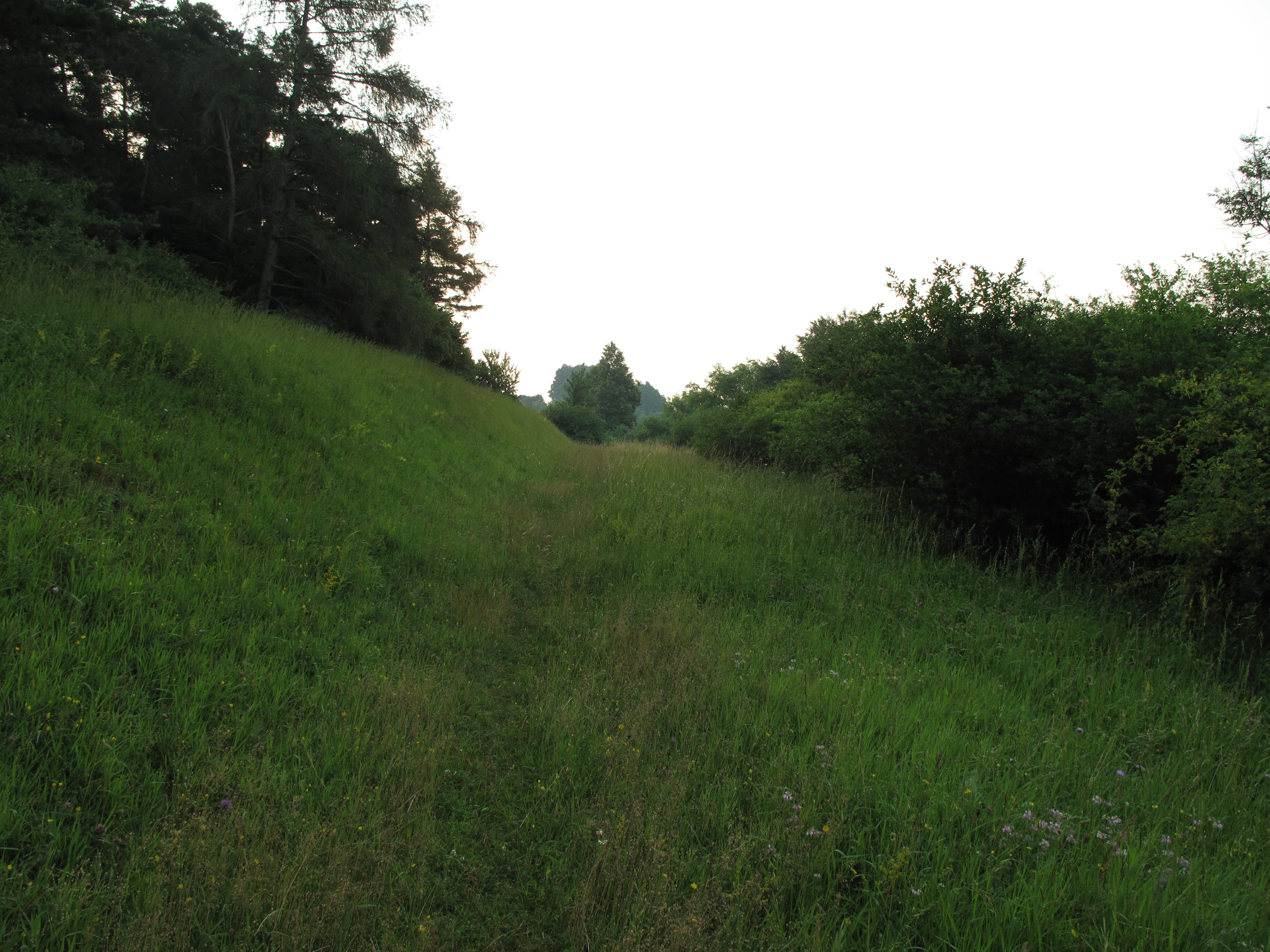
A slightly overgrown grassy path or clearing bordered by trees on the left and dense shrubs on the right at Výří vrch.
A grassy clearing at Výří vrch, flanked by trees and vegetation.

Výří vrch history and protected-area timeline

Výří vrch was formally declared as a natural monument on 5 March 2010, by the management authority of the Blanský les Protected Landscape Area. The designation followed longer-term recognition of the hill's geological and biological importance within the broader protected landscape, and was intended to ensure that its exposed limestone habitats and associated specialist species were maintained in the long term.

The 2010 declaration came within a framework of wider protected-area management in the Český Krumlov district, where many small nature monuments have been established in parallel with the larger Blanský les Protected Landscape Area to safeguard individual features such as outcrops, meadows, and steppe-like grasslands. The site's relatively recent official protection reflects the growing awareness, in Czech conservation practice, of the importance of small-scale calcareous habitats for regional biodiversity.

Výří vrch landscape and geographic character

The dominant physical feature of Výří vrch is an exposed limestone hill rising roughly 570 to 650 meters above sea level, set within the broader forested terrain of the Blanský les area. The slope reveals bare calcareous rock interspersed with thin, dry soils, producing an open and rugged surface structure that contrasts strongly with the closed forests that surround it.

The hill's character is shaped by its geology. Calcium-rich rock influences soil chemistry, drainage, and surface temperature, while the lack of dense tree cover allows sunlight to reach the ground across much of the site. Together, these conditions create a warm, dry, stony environment that supports steppe-like vegetation, scattered shrubs, and open woodland rather than the closed mesic forest typical of the region. The result is a small but visually striking limestone inselberg within a wider sea of mixed forest.
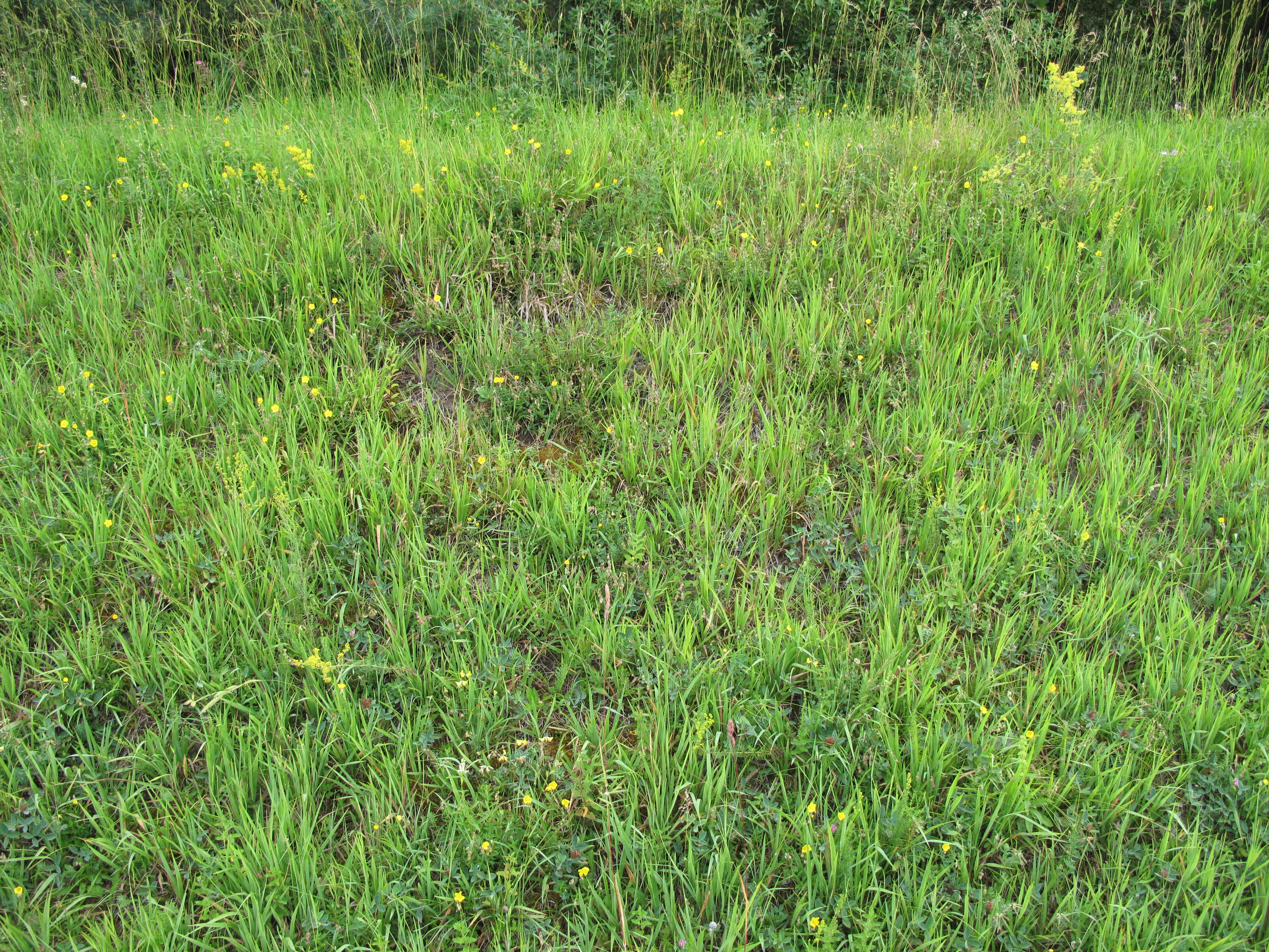
A close-up view of a grassy meadow featuring tall green grasses and scattered small yellow wildflowers.
Xerothermic grassland community at Výří vrch natural monument.

Výří vrch ecosystems, habitats, and plant life

The natural value of Výří vrch lies in the convergence of geological and climatic conditions that create xerothermic habitats rare in South Bohemia. The exposed limestone substrate supports xerothermic herb-grass communities, characterized by drought-adapted flowering plants, low-growing grasses, and specialized steppe species that thrive on thin calcareous soils.

Augmenting these open communities are two woodland types: thermophilous oak woodlands in the warmer, more exposed positions, and calcareous beech stands in slightly cooler but still lime-rich areas. This vegetation mosaic is unusual for the region and explains why the site has been singled out for protection even though its area is modest. Botanical highlights include blood-red cranesbill (Geranium sanguineum), red helleborine (Cephalanthera rubra), and the threatened hawkweed-like Crepis praemorsa, all species linked to warm, open, calcareous conditions.

Výří vrch wildlife and species highlights

While flora drives much of the site's recognition, Výří vrch also supports a distinctive invertebrate and reptile fauna closely tied to its dry, open habitats. The most notable species is the western skipper butterfly (Pyrgus trebevicensis), a rare steppe-associated butterfly recorded here as a particularly valuable occurrence.

Ground beetles (Carabidae) are exceptionally well represented, with seventy-nine documented species inhabiting the site, an unusually rich assemblage that reflects the warm, dry microclimate. The mollusc fauna similarly shows steppe affinities, including land snails such as Xerolenta obvia and Chondrula tridens, which are characteristic of open calcareous grasslands. Among vertebrates, the smooth snake (Coronella austriaca) is a regular inhabitant, drawn to the open rocky habitat and its prey base.

Výří vrch conservation status and protection priorities

Výří vrch is protected primarily because it functions as a refugium for xerothermic biodiversity within the Blanský les Protected Landscape Area. The site's mosaic of exposed rock, dry grassland, and open woodland is highly sensitive to changes in land use or forest cover, and once lost, its specialist species would be difficult to replace. Its protected status therefore aims to keep the hill open, warm, and free from succession that would otherwise shade out the calcareous steppe communities.

The broader conservation significance of the site relates to the role of small calcareous outcrops as biodiversity hotspots in landscapes dominated by acidic substrates. By safeguarding a representative example of this pattern, the reserve contributes to maintaining regional species pools, supports rare invertebrates, and helps preserve the genetic and ecological diversity on which larger-scale conservation in South Bohemia depends.

Top sights and standout views in Výří vrch

A defining feature of Výří vrch is the way it concentrates so much ecological interest into a very small footprint: exposed limestone, dry grassland, thermophilous oak woodland, and calcareous beech forest all coexist here, supporting a steppe-like flora and an unusually species-rich ground beetle assemblage.

The combination of a protected designation from 2010, its position within the Blanský les Protected Landscape Area, and its proximity to the heritage-rich town of Český Krumlov gives the site both a precise ecological role and a recognizable cultural-geographical context within South Bohemia.

Best time to visit Výří vrch

Výří vrch is primarily a conservation site rather than a heavily marketed visitor destination, so the most rewarding times to experience it tend to align with the seasons when xerothermic habitats are most visible. Late spring through early summer generally brings the broadest display of grasses and wildflowers in the dry grassland and oak woodland communities, while warm summer days support the highest activity of insects, including the steppe butterflies and ground beetles for which the site is known.

Autumn and winter offer quieter, more austere conditions, in which the underlying limestone outcrops and open woodland structure become easier to observe. Because the terrain is open and exposed, visitors should be prepared for weather-appropriate clothing on any visit, and should avoid disturbing the very habitats that give the hill its value.

Monthly climate preview

Long-term representative averages tracking monthly temperature variations and precipitation flow at Výří vrch

Výří Vrch Climate Normals: Annual Temperature and Precipitation Rhythms

Historical data records long-term temperature ranges and precipitation rates measured across twelve distinct monthly intervals at Výří vrch. Examining the complete monthly climate profile reveals detailed thermal transitions and precipitation patterns across the protected landscape.
Annual mean8 °C
-3 °C19 °C
Jan-3°
Feb-1°
Mar
Apr
May13°
Jun17°
Jul19°
Aug19°
Sep13°
Oct
Nov
Dec-2°
Warmest month
July

18.8 °C

Coolest month
January

-2.8 °C

Wettest month
July

3 mm/day

Driest month
February

1.1 mm/day

Park location guide

Geography guide, regional context, and park location map for Výří vrch

Výří vrch park geography, regions, and map view in Czechia

Understand where Výří vrch sits in Czechia through a broader geographic reading of the surrounding landscape, nearby location context, and its mapped position within the national park landscape.

How Výří vrch fits into Czechia

Czech Republic is a landlocked Central European country with a population of approximately 10.9 million people. The nation was established as an independent state on January 1, 1993, following the dissolution of Czechoslovakia. Its capital and largest city is Prague, with other major urban centers including Brno, Ostrava, Plzeň, and Liberec.

Wider geography shaping Výří vrch in Czechia

The Czech Republic is a landlocked country in Central Europe. It is bordered by Germany to the west, Austria to the south, Poland to the northeast, and Slovakia to the southeast. The landscape is predominantly hilly, with the territory covering 78,871 square kilometers.

Map view of Výří vrch

Use this park location map to pinpoint Výří vrch in Czechia, understand its exact geographic position, and read its mapped placement within the surrounding landscape more clearly.

Pigeon | © OpenStreetMap contributors

Location context for Výří vrch

Jihočeský kraj

Explore photographic records of exposed rock, dry grasslands, and unique terrain features

Výří vrch Photos and Landscape Scenery: Visualizing Protected Limestone Habitats

Visual documentation of Výří vrch reveals the rugged topography of exposed limestone outcrops and rare xerothermic habitats across the protected landscape. Examining field photography helps researchers interpret the distinct transition from open oak woodland to calcareous beech forest within the region.

A slightly overgrown grassy path or clearing bordered by trees on the left and dense shrubs on the right at Výří vrch.

A wide view of an open, grassy field in the foreground leading up to a densely forested hillside under an overcast sky.

A close-up view of a grassy meadow featuring tall green grasses and scattered small yellow wildflowers.

Park atlas

Compare regional geography, limestone terrain, and connected conservation areas

Exploring Other Parks Near Výří Vrch and Surrounding Protected Landscapes

Continue geographic comparison by browsing other protected areas located near Výří vrch across the surrounding regional terrain. This targeted park discovery reveals wider ecological patterns and connects individual limestone habitats to broader South Bohemian geography.
Watercolor illustration of a soft, rolling landscape with purple hills in the distance and pale green and pink vegetation in the foreground.
Natural monumentJihočeský kraj
About 3.6 km away#1 closest

West

Meandry Chvalšinského potoka Natural Monument: Mapped River Geography and Valley Terrain

Protected riparian habitat in the South Bohemian landscape

This natural monument protects a remarkably intact stretch of the Chvalšinský potok, where natural meanders, cut banks, and point bars create a living laboratory of fluvial geography. Beyond the stream itself, the site encompasses moist thistle and sedge meadows, offering a clear view into the traditional wetland ecology of the region. As a protected enclave, it maintains essential hydrological integrity within the broader landscape of the Czech countryside.

Area
0.048 km²
Established
2001
IUCN
IV
Relief
Lowland
A watercolor painting of a rolling mountain landscape with forests, depicted in varying tones of green, orange, and purple, set against a white background.
Nature reserveJihočeský kraj
About 11 km away#2 closest

Northwest

Ptačí stěna Nature Reserve: Mapped Geographic Profile of South Bohemian Protected Forests

Granulite cliff landforms and submontane beech forest mapping.

Ptačí stěna Nature Reserve occupies a steep southwestern slope in the Blanský les, defined by a linear granulite frost-riven cliff and a vast talus field of boulders up to three meters across. This protected area showcases the interplay between mature 150-year-old beech woodlands and rugged, cool microhabitats that support unique species. The site serves as a vital example of layered forest and rock conservation in South Bohemia.

Area
0.205 km²
Established
1996
IUCN
IV
Relief
Mountain
A horizontal watercolor illustration depicting soft, rolling green hills and distant pink-toned mountain silhouettes against a white background.
Natural monumentJihočeský kraj
About 11 km away#3 closest

Northwest

Na Stráži Natural Monument: Protected Grassland Geography in the Czech Republic

A botanically significant meadow in the South Bohemian landscape

Na Stráži is an important natural monument situated on a steep hillside in the Jihočeský kraj region. Known for its population of green-winged orchids and unique thermophilous acidophilic grasslands, this protected meadow provides a critical example of small-scale habitat conservation within the larger Blanský les protected landscape.

Area
0.037 km²
Established
1993
IUCN
IV
Relief
Upland
Nature reserveJihočeský kraj
About 11 km away#4 closest

Northeast

Vltava u Blanského lesa: Protected Natural Monument and River Valley Geography

Mapping the riparian landscape and conservation corridors in Jihočeský kraj

Situated in the Jihočeský kraj, Vltava u Blanského lesa is a designated nature reserve encompassing a unique river valley corridor. This area bridges the transition between aquatic river habitats and surrounding terrestrial meadows, protecting a structural mosaic essential for threatened plant and animal populations across several kilometers of the upper Vltava.

Area
4.78 km²
Established
2014
IUCN
III
Relief
Upland
A soft watercolor illustration of a pond landscape with grassy banks, reeds, and soft green vegetation in the background.
Nature reserveJihočeský kraj
About 19 km away#5 closest

North

Rybník Motovidlo Nature Reserve: Geographic Overview and Protected Area Profile

A critical aquatic landscape within the Jihočeský kraj region

Rybník Motovidlo is a specialized nature reserve in the Czech Republic, recognized for its role in conserving endangered aquatic vegetation and providing a refuge for diverse amphibian fauna. Its geographic position within the České Budějovice Basin links it to the broader network of South Bohemian ponds. The site serves as a vital case study for the integration of traditional pond management with modern biodiversity protection in a wetland-focused environmental context.

Area
0.116 km²
Established
2022
IUCN
III
Relief
Lowland
Nature reserveJihočeský kraj
About 19 km away#6 closest

Southwest

Velké bahno Nature Reserve: Protected Wetland and Mire Geography in the Šumava Foothills

Essential conservation habitat within the Jihočeský kraj region of the Czech Republic

Velké bahno stands as a compact but vital nature reserve featuring spruce-alder swamps, wooded peatlands, and boggy clearings. Its position within the Šumava Protected Landscape Area highlights a concentration of sensitive mire habitats, protected flora, and rare species adapted to the wet, undulating paragneiss terrain of the Bohemian Forest foreland.

Area
0.915 km²
Established
1992
IUCN
IV
Relief
Upland
Natural monumentJihočeský kraj
About 23 km away#7 closest

Northeast

Vrbenská tůň Natural Monument: Wetland Geography and Protected Landscape Analysis

A significant oxbow wetland fragment in the South Bohemian region.

Vrbenská tůň functions as a protected natural monument focused on the conservation of lowland pond ecosystems. Located within the Jihočeský kraj, this area offers a window into the hydrology of the České Budějovice Basin, supporting specialized amphibian populations and aquatic flora within its restored basin and surrounding buffer zones.

Area
0.009 km²
Established
1974
IUCN
III
Relief
Lowland
Natural monumentJihočeský kraj
About 23 km away#8 closest

North

Velký Karasín Natural Monument: Mapped Wetland Geography and Protected Landscape Context

A protected wetland sanctuary in the South Bohemian Region of the Czech Republic.

Discover the geographic character of Velký Karasín, a compact natural monument featuring an eutrophic fishpond and fringing reed beds. This protected area serves as an essential site for waterbirds and endangered dragonfly populations, offering a clear example of wetland preservation amidst the gently undulating terrain of the České Budějovice District.

Area
0.108 km²
Established
1991
IUCN
IV
Relief
Lowland

Common questions about visiting, size, designation, and location context for Výří vrch

Výří vrch FAQs for park facts, access, geography, and protected area context

Find quick answers about Výří vrch, including protected-area facts, park geography, trail and visitor context, and how the park fits into its surrounding country and regional landscape.
MoriAtlas Explorer

Continue Your Protected Areas Search Across the Global Atlas

Deepen your exploration by continuing the structured search for national parks and protected areas worldwide. Utilize the comprehensive filtering capabilities to compare different conservation landscapes and refine your understanding of global park geography. Discover more about the distribution and characteristics of protected natural areas.

Global natural geography