Mori Atlas logo
Nature reserveWaldmoore bei Großdittmannsdorf

A preserved landscape mosaic of forest mires, peat bodies, and rare swamp woodland habitats

Waldmoore bei Großdittmannsdorf Protected Nature Reserve in the Free State of Sachsen, Germany

(Naturschutzgebiet Waldmoore bei Großdittmannsdorf)

Waldmoore bei Großdittmannsdorf constitutes a vital nature reserve within the southern Laußnitzer Heide of Sachsen, Germany. This protected area safeguards a diverse mosaic of forest mires, nutrient-poor wet habitats, spring heads, and small water bodies that form a critical ecological anchor in the regional landscape. By preserving these rare wetland structures and mature woodland stands, the reserve maintains a distinct geographic identity as a sheltered, water-rich pocket within the wider Saxon lowlands.

forest mirebog woodlandpeatlandswamp forestsaxon lowlandsnature reserve

Waldmoore bei Großdittmannsdorf

Nature reserve

Park overview

Structured park overview, official facts, and landscape profile for Waldmoore bei Großdittmannsdorf

Waldmoore bei Großdittmannsdorf park facts, protected area profile, and essential visitor context

Review the core facts for Waldmoore bei Großdittmannsdorf, including designation, size, terrain, visitor scale, habitats, and operating context in one park-focused overview.

About Waldmoore bei Großdittmannsdorf

Waldmoore bei Großdittmannsdorf occupies a quiet but ecologically important position in the Saxon lowland landscape northeast of Dresden. The reserve protects roughly 93.5 hectares of forested wetland in the southern part of the Laußnitzer Heide, a wide heath and forest region stretching between Radeburg, Moritzburg, and the northern edge of the Dresden basin. Although small in absolute terms, the area represents an unusually intact fragment of mire and swamp forest that has survived the widespread drainage and forest conversion that affected much of the surrounding region in past centuries.

The protected landscape is shaped by a typical Saxon lowland setting: gently undulating sandy and loamy terrain underlain by glacial and periglacial deposits that allow water to accumulate locally. In the Waldmoore, these conditions have produced a mosaic of bog and swamp habitats rather than any single dominant feature. Active peat and bog bodies, often draped beneath a canopy of bog woodland, form the ecological core of the reserve; around them, sedge- and rush-rich wet stands, spring seepage zones, and small semi-natural water bodies create transitional habitats that link the wet core to the surrounding forest.

From a conservation standpoint, the reserve's significance extends well beyond its small footprint. It is formally embedded in the European Natura 2000 network as part of the Habitats Directive site "Moorwaldgebiet Großdittmannsdorf" (FFH area 4748-303), giving the nationally designated NSG an additional layer of EU-level protection and obligations for habitat management. Old and hollow-bearing trees scattered through the wooded sections add structural complexity, providing nesting and roosting opportunities for specialist species and reinforcing the value of the site as a refuge for woodland wetland communities in an increasingly fragmented Saxon lowland environment.

Quick facts and research context for Waldmoore bei Großdittmannsdorf

Waldmoore bei Großdittmannsdorf is a Saxon nature reserve (NSG) of about 93.5 hectares, designated on 19 December 2000 by order of the Dresden regional government. It carries the official identifier NSG D 99 and is recorded in the World Database on Protected Areas under WDPA ID 319279. The site falls within the IUCN management category IV (Habitat/Species Management Area).

The protected area lies in the southern Laußnitzer Heide, north of the village of Boden, part of the town of Radeburg, and extends across both the Landkreis Meißen and the Landkreis Bautzen. It is geographically anchored in the Saxon lowlands north of Dresden, forming part of the larger EU Habitats Directive site "Moorwaldgebiet Großdittmannsdorf" (FFH area 4748-303).

Protection and recognition

Explore the documented conservation framework and official records for Waldmoore bei Großdittmannsdorf.

Waldmoore bei Großdittmannsdorf Protection Status and Recognition Data

Examine the verified protection status and recorded administrative framework governing Waldmoore bei Großdittmannsdorf within global databases. Review the structured conservation metrics and formal designation records associated with this protected natural area.

Protection details

WDPA ID
319279
Park context

Deeper park guide and search-rich context for Waldmoore bei Großdittmannsdorf

Waldmoore bei Großdittmannsdorf history, landscape, wildlife, and travel context

Explore Waldmoore bei Großdittmannsdorf through its history, landscape character, ecosystems, wildlife, conservation priorities, cultural context, and seasonal travel timing in a structured park guide built for atlas discovery and search intent.

Why Waldmoore bei Großdittmannsdorf stands out

The reserve is best known for protecting a coherent complex of woodland mires and associated bog structures within the Laußnitzer Heide. Its defining feature is the combination of intact peat and bog bodies with surrounding swamp forest, sedge- and rush-rich wet stands, spring areas, and near-natural small water bodies; these elements together form the structural heart of the protected landscape. The site is also recognized for the presence of old, hollow-bearing trees and small clusters of veteran timber that create rare microhabitats in an otherwise intensively used Saxon plain. Its integration into the EU-wide Natura 2000 network through the Moorwaldgebiet Großdittmannsdorf FFH area adds a continental layer of conservation significance to what would otherwise register as a small, locally important wetland reserve.
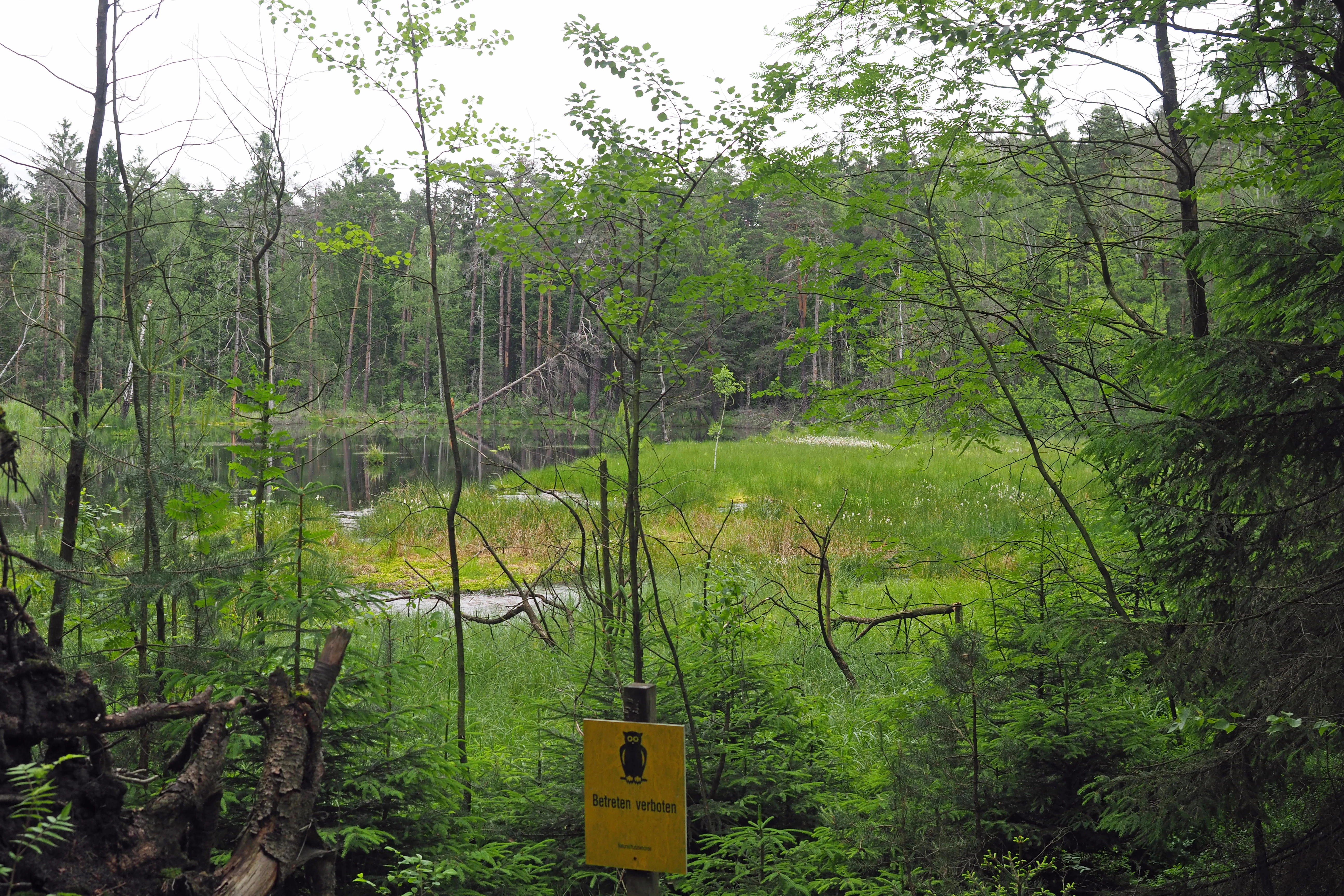
A green forested bog and wetland area with a yellow nature reserve sign in the foreground.
A view of the wetland and forest habitat within the Waldmoore bei Großdittmannsdorf nature reserve.

Waldmoore bei Großdittmannsdorf history and protected-area timeline

Waldmoore bei Großdittmannsdorf has no centuries-old history as a named park or royal hunting ground. As a formally designated protected area it is a comparatively recent creation: the Saxon government set the reserve aside by regulation of the Regierungspräsidium Dresden on 19 December 2000, with the order published in the Saxon official gazette in early 2001 and amended on 6 November 2001.

Although the legal designation is recent, the ecological features that justified it developed over much longer timescales. The mires, peat bodies, and swamp forests of the southern Laußnitzer Heide formed gradually through post-glacial hydrological processes, and their survival into the late 20th century depended on the persistence of relatively traditional, low-intensity woodland management in parts of the area. The 2000 designation effectively froze this legacy into a formal protected status, bringing the site simultaneously into the Saxon NSG system and, through the parallel Moorwaldgebiet Großdittmannsdorf site, into the EU Natura 2000 framework.

Waldmoore bei Großdittmannsdorf landscape and geographic character

The landscape of Waldmoore bei Großdittmannsdorf is a quiet, low-energy scene typical of the Saxon lowlands just north of Dresden. Elevations vary only gently across the reserve, and the ground surface is shaped by sandy and loamy substrates inherited from glacial and periglacial processes. Rather than dramatic relief, the defining topographic quality is a subtle pattern of slight depressions where water gathers and ridges where the forest floor stays drier.

The visible character of the area is overwhelmingly forested. Bog woodland stands and associated swamp forest give the reserve its close-canopied, shaded feel, while scattered clearings and light gaps around wet flushes and spring heads create darker, more open micro-landscapes of sedges, rushes, and shallow-water vegetation. Small semi-natural ponds and the land-water transition zones around them add further textural variety to what is otherwise a continuous mosaic of damp forest and mire.

Embedded within the broader Laußnitzer Heide, the reserve reads as one of the wettest, most sheltered fragments of that larger lowland heath-and-forest landscape. Its boundaries, although administratively precise, blend into surrounding woodlands and heathlands managed for very different purposes, reinforcing the impression of a small, persistently damp pocket within a much wider, drier regional matrix.

Waldmoore bei Großdittmannsdorf ecosystems, habitats, and plant life

Ecologically, Waldmoore bei Großdittmannsdorf is a textbook example of a lowland forest-mire complex. The reserve's natural value rests on a tightly interwoven set of wetland habitats, all held together by the local hydrology of the Laußnitzer Heide. Peat and bog bodies form the structural backbone; around them, the protected area maintains swamp forests, sedge- and rush-rich wet sites, spring seepage zones, and fragments of near-natural stillwater habitat.

The protected biotope inventory explicitly targets these particular structures for preservation and development, rather than treating the reserve as a generic woodland. Active peat layers and forest mires are the most distinctive features, while the inclusion of spring heads and small pools ensures that the hydrological network feeding the bog remains functional. Verlandung zones, where standing water is gradually colonised by vegetation, provide dynamic edges that connect open water to mire and forest.

Adding structural diversity, the reserve contains old, hollow-bearing tree clusters and individual veteran trees scattered through the canopy. These so-called Altholzinseln and Einzelbäume are recognised within the conservation objectives as habitats in their own right, ensuring that the wooded character of the site is not reduced to a uniform, even-aged stand.

Waldmoore bei Großdittmannsdorf wildlife and species highlights

The reserve's wildlife profile is shaped less by charismatic large mammals than by the specialist fauna associated with bog woodland, old trees, and small wetland features. The presence of mature and decaying timber, with cavities, dead wood, and bark crevices, makes the wooded sections particularly valuable for saproxylic insects, hole-nesting birds, and bats that use tree hollows as roosting sites.

Around the wetter habitats; the sedge and rush stands, spring heads, and small pools; typical lowland mire fauna is expected, including amphibians tied to shallow, fish-free standing water and invertebrates adapted to seasonally saturated peat substrates. The combination of structural diversity (water, mire, swamp forest, old trees) means the reserve supports overlapping rather than isolated wildlife communities, which is one of the arguments for managing the area as an interconnected wetland landscape rather than a set of separate patches.

Waldmoore bei Großdittmannsdorf conservation status and protection priorities

The conservation status of Waldmoore bei Großdittmannsdorf rests on two overlapping layers. At the national level it is a Naturschutzgebiet under German nature conservation law, formally established in 2000 and assigned the identifier D 99. Internationally, it is classified by the IUCN as a Category IV protected area (Habitat/Species Management Area), reflecting its purpose as an actively managed refuge for specific habitat types and associated species rather than a strict wilderness reserve.

Equally important is the site's place within the European Natura 2000 network. Waldmoore bei Großdittmannsdorf is wholly contained within the Habitats Directive site "Moorwaldgebiet Großdittmannsdorf" (FFH area 4748-303), meaning that the protection of bog woodland habitat types in the Saxon lowlands is formally recognised at the EU level. This dual status gives the reserve a conservation weight well above its modest size and ties its management to habitat-specific objectives laid out in the designation order, including the preservation and development of peat bodies, swamp forests, spring areas, and old-growth tree habitats.

Top sights and standout views in Waldmoore bei Großdittmannsdorf

Waldmoore bei Großdittmannsdorf stands out for the density of its wetland-forest habitat mosaic within a very small area; peat bodies, swamp woodland, spring flushes, and old-growth trees all sit within a few hundred metres of one another. The reserve's formal embedding in the Natura 2000 network via the Moorwaldgebiet Großdittmannsdorf FFH site gives it a conservation profile that extends well beyond a typical local NSG, while its location in the southern Laußnitzer Heide places it within a regional landscape of heath, forest, and historical Saxon land use north of Dresden.

Best time to visit Waldmoore bei Großdittmannsdorf

As a quiet, low-relief wetland woodland without formal visitor infrastructure, the reserve is best appreciated through the seasonal rhythm of the Saxon lowland forest. Late spring and early summer bring the most visible botanical activity around the sedge- and rush-rich wet stands and along the spring heads; autumn reveals the structural character of the bog woodland, with mature and decaying trees particularly prominent once the leaf canopy thins. Winter visits, when the ground is firm, can also offer a clearer sense of the underlying topography and the contrast between wetter mires and drier forested ridges.

Monthly climate preview

Long term representative point measurements for temperature and precipitation patterns

Waldmoore bei Großdittmannsdorf Climate Normals and Annual Temperature Rhythm

Recorded baseline metrics outline the measured annual temperature progression and daily precipitation rates across twelve distinct intervals at Waldmoore bei Großdittmannsdorf. Examining the complete monthly climate dataset provides deeper comparative context on long term meteorological normals.
Annual mean8 °C
-2 °C19 °C
Jan-2°
Feb-1°
Mar
Apr
May13°
Jun17°
Jul19°
Aug19°
Sep14°
Oct
Nov
Dec-1°
Warmest month
July

19.1 °C

Coolest month
January

-1.8 °C

Wettest month
July

2.8 mm/day

Driest month
April

1.3 mm/day

Park location guide

Geography guide, regional context, and park location map for Waldmoore bei Großdittmannsdorf

Waldmoore bei Großdittmannsdorf park geography, regions, and map view in Germany

Understand where Waldmoore bei Großdittmannsdorf sits in Germany through a broader geographic reading of the surrounding landscape, nearby location context, and its mapped position within the national park landscape.

How Waldmoore bei Großdittmannsdorf fits into Germany

Germany is a federal republic in Western and Central Europe with a population of over 83 million across sixteen constituent states. It is Europe's largest economy by nominal GDP and a major global exporter and importer. The capital is Berlin, and the country borders Denmark, Poland, Czech Republic, Austria, Switzerland, France, Luxembourg, Belgium, and the Netherlands.

Wider geography shaping Waldmoore bei Großdittmannsdorf in Germany

Germany is located in Western and Central Europe, spanning 357,022 km². It borders Denmark to the north, Poland and the Czech Republic to the east, Austria and Switzerland to the south, and France, Luxembourg, Belgium, and the Netherlands to the west. The country has coastlines on the Baltic Sea and North Sea to the north, with the Alps located in the southern region.

Map view of Waldmoore bei Großdittmannsdorf

Use this park location map to pinpoint Waldmoore bei Großdittmannsdorf in Germany, understand its exact geographic position, and read its mapped placement within the surrounding landscape more clearly.

Pigeon | © OpenStreetMap contributors

Location context for Waldmoore bei Großdittmannsdorf

Sachsen

Visual reference for forest mires, peatland habitats, and Saxon lowland nature reserve terrain.

Waldmoore bei Großdittmannsdorf Photos and Scenery: Exploring Protected Wetland Landscapes

Visual records capture the dense mosaic of forest mires, swamp woodland, and spring flushes shaping the protected reserve environment. Examining these protected landscapes reveals the subtle topography, wet habitats, and peatland character defining the local ecosystem.

A green forested bog and wetland area with a yellow nature reserve sign in the foreground.

Park atlas

Compare nearby protected landscapes and wetland forest habitats across the Saxon lowlands.

Exploring Parks Near Waldmoore bei Großdittmannsdorf and Regional Reserves

Browse other parks near Waldmoore bei Großdittmannsdorf to examine related wetland reserves, forest mires, and protected landscapes across the surrounding region. Extending your geographic comparison reveals how local peatland habitats and lowland conservation areas connect within the broader Saxon terrain.
A watercolor painting showing a calm pond with a small island of green trees and distant rolling hills under a soft pink and yellow sky.
Nature reserveMeißen District
About 6.7 km away#1 closest

Southwest

Frauenteich Moritzburg: Mapping the Protected Wetland Landscapes of Meißen District

Glacial pond basins and diverse forest habitats in Saxony.

Frauenteich Moritzburg serves as a core component of Saxony's pond landscape, protecting a rich sequence of shoreline vegetation and open water. Its geography reflects the results of ancient glacial activity, creating a unique environment where sandy ridges and wet meadows coexist. This nature reserve provides essential refuge for bird populations, making it a focal point for understanding the natural, protected terrain within the broader Meißen District environment.

Area
2.02 km²
Established
1954
IUCN
IV
Relief
Lowland
A pale, soft watercolor painting depicting a small arched bridge crossing a gentle stream within a rolling green valley.
Protected landscapeSaxony
About 9.9 km away#2 closest

Southeast

Seifersdorfer Tal Protected Landscape and Cultural Heritage in Saxony

A historic garden monument and river valley ecosystem

The Seifersdorfer Tal is a protected landscape defining the Große Röder valley. Beyond its cultural status as one of Germany's earliest English-style landscape gardens, the area serves as a vital riverine corridor and nature reserve. The terrain offers a unique blend of rocky outcrops, wooded slopes, and meadows linked by historic footpaths and 18th-century allegorical monuments.

Area
2.88 km²
Established
1960
Relief
Upland
Climate
Temperate
A horizontal watercolor illustration showing a calm pond in the foreground, with lush green vegetation on the banks and rolling hills in the background under a soft sky.
Nature reserveMeißen
About 11 km away#3 closest

Southwest

Dippelsdorfer Teich Nature Reserve: Geographic Insights and Landscape Context

Historic Saxon pond management and regional protected landscape.

The Dippelsdorfer Teich serves as a primary example of historical pond construction and nature protection in the northern Dresden countryside. This 69 hectare reservoir captures a blend of ecological, cultural, and recreational values within the Meißen region. Users can examine its physical layout, the dam structure, and the integration of heritage transport within this managed lowland environment.

Area
0.69 km²
Established
1528
Relief
Lowland
Scope
Terrestrial
Nature reserveSachsen
About 21 km away#4 closest

West

Winzerwiese und Gosebruch: Protected Nature Reserve and Valley Geography in Sachsen

Mapping protected wet meadows and floodplain woodlands

Winzerwiese und Gosebruch is a distinctive nature reserve in Sachsen, Germany, centered on a small valley along the Gosebach stream. This protected area creates a dense mosaic of wet meadow, marshy woodland, and dry deciduous forest, offering a significant look at the region's diverse botanical landscape and river-valley geography.

Area
0.116 km²
Established
1967
IUCN
IV
Watercolor painting of a soft landscape featuring distant hills and foreground vegetation in shades of green, yellow, and soft red.
Nature reserveSachsen
About 21 km away#5 closest

South

Dresdner Elbtalhänge Nature Reserve: Geography, Mapped Boundaries, and Landscape Context

An essential nature reserve along the Elbe valley in Sachsen

Dresdner Elbtalhänge captures the striking transition between the flat Elbe floodplain and the Westlausitz hill region. This detailed atlas entry covers the reserve's unique geomorphology, including its incised ravine systems, south-facing oak forests, and exposed rock formations that define its protected character within Sachsen.

Area
203.6 km²
Established
2007
IUCN
IV
A pale, soft watercolor illustration showing a horizontal landscape of light green trees, shrubs, and rolling grassy plains on a white background.
Nature reserveGermany
About 24 km away#6 closest

South

Elbinseln Pillnitz und Gauernitz: A Study in Protected Saxon River Landscapes

Examining floodplain geography and rare river island ecosystems

Located in the Elbe valley between Dresden and Meissen, Elbinseln Pillnitz und Gauernitz preserves the final natural river islands within the state of Saxony. This protected nature reserve anchors a vital network of alluvial soils, riparian woodlands, and unarmored riverbanks, offering a unique perspective on the dynamic floodplain geography of Germany's major river corridors.

Area
0.235 km²
Established
2006
IUCN
IV
Relief
Lowland
A soft, light-toned watercolor painting of a low, rolling landscape with green hills, sparse vegetation, and a suggestion of wetland or pond in the foreground.
Nature reserveSachsen
About 24 km away#7 closest

West

Seußlitzer und Gauernitzer Gründe: Protected Nature Reserve Map and Landscape Overview

Regional geography and habitat boundaries in the Sachsen Elbe valley.

Spanning steep slopes and narrow brook valleys on both sides of the Elbe, Seußlitzer und Gauernitzer Gründe is a defining nature reserve in Sachsen. This protected area supports a diverse mix of dry herbaceous vegetation and mature deciduous forest, serving as a critical component of the local ecological network within the broader Upper Elbe landscape.

Area
3.57 km²
Established
2013
IUCN
IV
Relief
Upland
Nature reserveFreistaat Sachsen
About 25 km away#8 closest

South

Windberg Nature Reserve: Mapping the Forested Ridge and Protected Landscape of Saxony

Geology, mining heritage, and protected oak-beech forest ecosystems

Windberg serves as the prominent local landmark for Freital, defined by its elongated forested plateau and complex tectonic geography. This nature reserve offers a study in the intersection of environmental conservation and human industrial history, featuring Saxony's deepest cave and varied habitats within the eastern Ore Mountains foothills.

Established
1967
Relief
Mountain
Climate
Temperate
Access
Easy access

Common questions about visiting, size, designation, and location context for Waldmoore bei Großdittmannsdorf

Waldmoore bei Großdittmannsdorf FAQs for park facts, access, geography, and protected area context

Find quick answers about Waldmoore bei Großdittmannsdorf, including protected-area facts, park geography, trail and visitor context, and how the park fits into its surrounding country and regional landscape.
MoriAtlas Explorer

Continue Your Protected Areas Search Across the Global Atlas

Deepen your exploration by continuing the structured search for national parks and protected areas worldwide. Utilize the comprehensive filtering capabilities to compare different conservation landscapes and refine your understanding of global park geography. Discover more about the distribution and characteristics of protected natural areas.

Global natural geography