

Mori Atlas logo
National parkWeddin Mountains National Park

Discover the protected landscape boundaries and regional context of this New South Wales national park.

Weddin Mountains National Park: National Park Geographic Identity and Atlas Exploration

Weddin Mountains National Park stands as a distinct national park entity within New South Wales, Australia, offering a focused point for geographic discovery. This page serves as a canonical entry for understanding its protected landscape and its position within the broader atlas. Users can explore the mapped boundaries of this natural area, gaining insight into its unique geographic setting and its significance as a designated national park.

Mountain rangesNew South WalesImportant Bird AreaEndangered species habitatBushranger historyRemnant vegetation

Weddin Mountains National Park

National park

Park overview

Structured park overview, official facts, and landscape profile for Weddin Mountains National Park

Weddin Mountains National Park park facts, protected area profile, and essential visitor context
Review the core facts for Weddin Mountains National Park, including designation, size, terrain, visitor scale, habitats, and operating context in one park-focused overview.

About Weddin Mountains National Park

Weddin Mountains National Park occupies a unique position in the central New South Wales landscape as an isolated mountain range rising from the surrounding flat agricultural country. The park's establishment in 1971 protected what was already evident: a small but ecologically significant pocket of remnant vegetation that had survived extensive land clearing due to the ruggedness of the terrain. The mountains form a crescent-shaped ridge running roughly north-south, with the steepest cliffs on the eastern side and more gentle slopes descending westward toward the flat plains. This topography created natural shelter and concealment that proved attractive to both wildlife seeking refuge and humans seeking escape from authority. The geological foundation lies within the Lachlan Fold system, representing ancient rock formations that have been uplifted and exposed over geological time. The park's relative isolation from larger mountain systems means it functions as a biodiversity island, supporting species that would otherwise be absent from this part of NSW. Visitor facilities are modest but functional, with the primary access point from the town of Grenfell via the Mid Western Highway. The park offers walking tracks that reward visitors with panoramic views from various lookouts, particularly Peregrine Lookout which provides sweeping vistas across the surrounding agricultural landscape.

Quick facts and research context for Weddin Mountains National Park

Weddin Mountains National Park covers an area of 83.61 square kilometres in central NSW, established in November 1971 under the management of the National Parks and Wildlife Service of New South Wales. The park is classified as an IUCN Category II protected area, representing national park status. The mountain range runs roughly north-south and forms a striking visual feature against the flat farmland of the Lachlan region. The park contains notable historic sites including the remnants of Seaton's Farm, a Depression-era agricultural property that demonstrates early 20th-century farming persistence in challenging conditions. The area is also known for its connection to colonial-era bushrangers who used the rugged terrain as a hideout.

Park context

Deeper park guide and search-rich context for Weddin Mountains National Park

Weddin Mountains National Park history, landscape, wildlife, and travel context
Explore Weddin Mountains National Park through its history, landscape character, ecosystems, wildlife, conservation priorities, cultural context, and seasonal travel timing in a structured park guide built for atlas discovery and search intent.

Why Weddin Mountains National Park stands out

Weddin Mountains National Park is best known for its dramatic contrast with the surrounding flat plains, creating a mountain island of native vegetation in an otherwise cleared agricultural landscape. The park is particularly significant for its population of endangered brush-tailed rock wallabies, which inhabit the rocky outcrops and cliff faces. It is also recognized as an Important Bird Area by BirdLife International due to its importance for the conservation of swift parrots and superb parrots. The historical association with notorious 19th-century bushrangers, particularly Ben Hall and his gang, adds a distinctive cultural dimension that sets this park apart from many other NSW protected areas. The well-preserved Seaton's Farm site provides a tangible window into early 20th-century rural life in the region.

Weddin Mountains National Park history and protected-area timeline

The human history of Weddin Mountains spans Indigenous occupation through to European settlement and protection. The mountains and surrounding country are part of Wiradjuri traditional country, the lands of the Indigenous peoples who inhabited this region long before European contact. In the mid-19th century, the Weddin Mountains became refuge for some of Australia's most famous bushrangers. Ben Hall, who terrorised the Forbes-Grenfell area during the 1850s, used the mountains as a base for his operations, holing up in a cave on the north-western side of the park with members of his gang including Johnnie Gilbert and Frank Gardiner. Local legend suggests Ben Hall buried treasure in the mountains that has never been recovered, adding an element of mystery to the landscape. The property known as Seaton's Farm represents another layer of human history, showing how settlers attempted to farm this marginal land during the Great Depression of the 1930s. The farm demonstrates resourceful use of available materials, with structures built from flattened corrugated iron to extend limited resources. The Seaton family occupied the property from the late 1920s through to the 1980s, and the site now forms part of the national park heritage trail.

Weddin Mountains National Park landscape and geographic character

The physical landscape of Weddin Mountains National Park is defined by its dramatic topographical contrast with the surrounding terrain. The mountains rise abruptly from the flat agricultural plains, creating a distinctive landform that is visible from considerable distances across the generally flat country of central NSW. The range reaches approximately 750 metres above Australian Height Datum at its highest point, with the ridge running roughly north-south in a crescent formation. The eastern side features steep cliff faces and rocky outcrops, while the western slopes descend more gradually toward the surrounding plains. The terrain is rugged and rocky, with numerous cliffs, boulders, and scree slopes that define the character of the higher ground. This ruggedness is precisely what allowed native vegetation to persist when the surrounding land was cleared for agriculture, as the terrain was unsuitable for farming. The underlying geology belongs to the Lachlan Fold system, representing ancient sedimentary and metamorphic rocks that have been complexly deformed over geological time.

Weddin Mountains National Park ecosystems, habitats, and plant life

The ecological character of Weddin Mountains National Park is defined by its function as a vegetation island in a largely cleared agricultural landscape. The park contains remnant vegetation communities that survived because the mountain terrain was too rugged for broadscale clearing. These communities support biodiversity values far exceeding what the small area might otherwise suggest. The park is part of the South-west Slopes of NSW Important Bird Area, recognised internationally by BirdLife International for its significance in conserving bird species, particularly the swift parrot and superb parrot. The rocky outcrops and cliff faces provide critical habitat for the endangered brush-tailed rock wallaby, a species that has declined significantly across its former range. The diverse birdlife includes painted honeyeater, swift parrot, little lorikeet, and turquoise parrot among the 216 recorded species. The pest species present include cats, rabbits, foxes, goats, and sheep, representing ongoing challenges for conservation management.

Weddin Mountains National Park wildlife and species highlights

The wildlife of Weddin Mountains National Park demonstrates remarkable diversity for such a small protected area, with 216 species of animals recorded within its boundaries. The mammal fauna includes three species of wallaby, most notably the endangered brush-tailed rock wallaby that inhabits the rocky cliff faces and outcrops throughout the range. This species has suffered significant declines across much of its former range, making the Weddin Mountains population particularly important for conservation. The avifauna is exceptionally diverse, with the park's status as an Important Bird Area reflecting its significance for species of conservation concern. The swift parrot, a migratory species that breeds in Tasmania and winters in mainland south-eastern Australia, utilises the park's resources. The superb parrot, also a migratory species, is found in the area. Additional notable bird species include painted honeyeater, little lorikeet, and turquoise parrot. Pest species including cats, rabbits, foxes, goats, and sheep are present in the park, representing ongoing pressures on native wildlife.

Weddin Mountains National Park conservation status and protection priorities

Weddin Mountains National Park represents an important conservation outcome in a landscape where the vast majority of native vegetation has been cleared for agriculture. The park protects critical habitat for the endangered brush-tailed rock wallaby, a species that has experienced severe range contraction across NSW. The designation as an Important Bird Area by BirdLife International recognises the park's international significance for conservation of swift parrots and superb parrots, both species facing declining populations. The remnant vegetation communities within the park serve as a genetic reservoir and ecological reference point for understanding the pre-clearing landscape of central NSW. Management challenges include controlling introduced pest species that impact native wildlife, particularly cats, rabbits, foxes, goats, and sheep. The park demonstrates how even small, isolated protected areas can retain significant biodiversity value when they protect terrain that was too rugged for agricultural conversion.

Weddin Mountains National Park cultural meaning and human context

Weddin Mountains National Park contains cultural heritage spanning Indigenous occupation and European settlement history. The mountains are situated within Wiradjuri country, the traditional lands of the Indigenous people who inhabited this region for thousands of years before European colonisation. The European cultural history is dominated by the legend of the bushrangers, particularly Ben Hall who used the mountains as a refuge during his period of operations in the Forbes-Grenfell area during the 1850s. The cave where Hall and his gang sheltered remains a point of historical interest within the park. Seaton's Farm provides a different but equally evocative window into the human story of this landscape, showing how a family attempted to make a living from marginal land during the difficult years of the Great Depression. The farm's resourceful construction, using whatever materials were available, tells a story of determination and hardship that resonates across Australian rural history.

Top sights and standout views in Weddin Mountains National Park

The Weddin Mountains present a rare mountain landscape in central NSW, rising dramatically from flat agricultural country to create a distinctive visual and ecological landmark. The endangered brush-tailed rock wallaby population represents a conservation priority, with the park providing critical habitat for this declining species. The Important Bird Area designation reflects exceptional avifauna diversity, with swift parrots and superb parrots among the notable species. Ben Halls Cave connects visitors to the bushranger era, while Seaton's Farm preserved within the park offers a tangible link to early 20th-century rural life. Walking trails to Peregrine Lookout and Eualdrie provide panoramic views across the surrounding plains from the mountain summit. The contrast between the rugged mountain terrain and the cleared farmland below illustrates why this area was never fully converted to agriculture.

Best time to visit Weddin Mountains National Park

The best time to visit Weddin Mountains National Park depends on the experience sought, though autumn and spring generally offer the most comfortable conditions for outdoor exploration. The cooler months from April to October provide pleasant temperatures for walking and camping, with minimal heat stress during daytime activities. Winter can bring cold nights and occasional frost, though the mountain terrain remains accessible for day visits. Summer months can be very hot in the central NSW plains, making the mountain trails more challenging and increasing fire risk during dry periods. Wildlife viewing may be most productive in the early morning or late afternoon when animals are more active, regardless of season. The park's camping facilities at Ben Halls Cave and Holy Camp allow for overnight stays, though visitors should be prepared for basic facilities and self-sufficient camping. Birdwatchers may find spring and autumn particularly rewarding when migratory parrot species are present.
Park location guide

Geography guide, regional context, and park location map for Weddin Mountains National Park

Weddin Mountains National Park park geography, regions, and map view in Australia
Understand where Weddin Mountains National Park sits in Australia through a broader geographic reading of the surrounding landscape, nearby location context, and its mapped position within the national park landscape.

How Weddin Mountains National Park fits into Australia

Australia is a constitutional monarchy and federal parliamentary democracy comprising six states and ten territories. With a population of nearly 28 million, it is one of the world's most urbanised countries, with most people concentrated on the eastern seaboard. The country has a high Human Development Index and is known for its cultural diversity, ancient Aboriginal heritage, and unique wildlife.

Wider geography shaping Weddin Mountains National Park in Australia

Australia occupies the entire Australian continent, the island of Tasmania, and numerous smaller islands. It is the world's flattest and driest inhabited continent, featuring vast deserts in the interior (the Outback), tropical rainforests along the eastern coast, and a coastline bordering the Indian and Pacific Oceans.

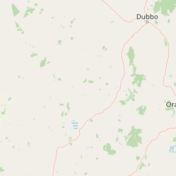
Map view of Weddin Mountains National Park

Use this park location map to pinpoint Weddin Mountains National Park in Australia, understand its exact geographic position, and read its mapped placement within the surrounding landscape more clearly.

Pigeon | © OpenStreetMap contributors

Location context for Weddin Mountains National Park

New South Wales
Park atlas

Browse diverse protected landscapes and regional park geography across central New South Wales.

Explore Nearby National Parks and Protected Areas Surrounding Weddin Mountains National Park
After exploring Weddin Mountains National Park, continue your discovery of nearby national parks and other protected areas across central New South Wales. This regional view allows for geographic comparison of diverse protected landscapes, including unique mountain formations and vital remnant vegetation.
National parkNew South Wales

Conimbla National Park: Protected Landscape Atlas and Regional Geography

Mapped boundaries and terrain within New South Wales.

Examine the protected landscape of Conimbla National Park, a designated national park situated in New South Wales, Australia. This entry provides focused geographic context, detailing its mapped boundaries and the regional terrain. It serves as a valuable resource for understanding the park's identity within the national atlas and its specific place in the Australian landscape.

Area
84.71 km²
Established
1980
IUCN
II
Relief
Upland
Watercolor depiction of a river, trees, and rolling hills in a landscape
National parkNew South Wales

Jindalee National Park: New South Wales National Park Protecting Cypress Pine Woodlands

Explore unique mapped terrain and regional conservation landscape.

Jindalee National Park represents a vital conservation effort in New South Wales, safeguarding remaining cypress pine woodlands and Critically Endangered grassy woodland ecosystems. Situated in the South West Slopes region, its undulating terrain and drainage lines form a distinctive natural landscape. The park's designation as a national park underscores its importance for preserving threatened species habitats and offers a focused point for atlas-driven discovery of its unique protected-area character and geographic context.

Area
10.76 km²
Established
2011
IUCN
II
Relief
Lowland
National parkNew South Wales

Nangar National Park: Australian National Park Geography and Mapped Boundaries

Explore the protected landscape within New South Wales.

Nangar National Park is a key protected area situated in New South Wales, Australia, offering a valuable point for geographic discovery. This page details its status as a national park, providing insight into its mapped boundaries and its role within the regional landscape. Users can utilize this information to understand the park's specific geographic context and its contribution to the broader atlas of Australia's protected lands.

Area
94 km²
Established
1983
IUCN
II
Relief
Mountain
National parkNew South Wales

Abercrombie River National Park: A Protected Landscape in New South Wales

Explore its national park designation and mapped geography.

Delve into the details of Abercrombie River National Park, a designated national park situated in New South Wales. This entry focuses on its identity as a protected landscape, providing a geographically specific atlas perspective. Understand the extent of its mapped boundaries and its contribution to the regional geography, offering a clear view of its protected area status for discovery and reference.

Area
190 km²
Established
1995
IUCN
II
Relief
Mountain
National parkNew South Wales

Brindabella National Park: A Protected Mountain Landscape in New South Wales' Australian Alps

Discover its mapped terrain and regional geographic context.

Brindabella National Park offers a unique perspective on the mountainous terrain of the Brindabella Range, forming a vital protected area within the Australian Alps. Located in New South Wales, its landscape features rugged ridgelines and diverse subalpine vegetation, recognized for its national environmental significance. This park serves as a key destination for understanding protected area geography and the mapped context of Australia's high country.

Area
184.54 km²
Established
1996
IUCN
II
Relief
Mountain
National parkRiverina

Cocoparra National Park: Semi-Arid Hill Country and Protected Landscape in Riverina

Explore mapped geography and key natural features of this Australian national park.

Cocoparra National Park is an essential protected natural area within Australia's Riverina region, noted for its striking semi-arid landscape. The park features a prominent range of low hills, including Bingar Mountain, rising from the predominantly flat terrain. This distinctive geography, characterized by rocky sandstone ridges and characteristic woodland communities, offers valuable insights into the region's natural heritage. As an Important Bird Area, Cocoparra National Park also holds significant conservation value for its avian populations and their unique inland habitat.

Area
83.57 km²
Established
1969
IUCN
II
Relief
Mixed relief
National parkNew South Wales

Livingstone National Park: National Park Protected Landscape and Geographic Context

Mapped terrain and protected area discovery for this New South Wales park.

Investigate Livingstone National Park as a key protected natural area in New South Wales. This detail entry offers insights into its mapped boundaries, regional geographic setting, and landscape character. Explore how this national park contributes to the broader atlas of Australian protected lands and understand its distinct natural terrain through detailed geographic data.

Area
19.19 km²
Established
2001
IUCN
II
Relief
Mixed relief
National parkNew South Wales

Mares Forest National Park: New South Wales National Park Atlas and Protected Landscape

Explore mapped boundaries and forest terrain.

Mares Forest National Park, situated in New South Wales, offers a distinct protected landscape defined by its wet eucalyptus forest and kurrajong trees. As a national park, it provides valuable insight into the regional geography of the Southern Tablelands, showcasing its unique terrain and role as wildlife habitat. This park serves as an essential point for atlas-based exploration of Australia's conservation estate, highlighting its mapped boundaries and natural features.

Area
25.59 km²
Established
2010
IUCN
II
Relief
Upland

Common questions about visiting, size, designation, and location context for Weddin Mountains National Park

Weddin Mountains National Park FAQs for park facts, access, geography, and protected area context
Find quick answers about Weddin Mountains National Park, including protected-area facts, park geography, trail and visitor context, and how the park fits into its surrounding country and regional landscape.
MoriAtlas Explorer

Continue Your Protected Areas Search Across the Global Atlas

Deepen your exploration by continuing the structured search for national parks and protected areas worldwide. Utilize the comprehensive filtering capabilities to compare different conservation landscapes and refine your understanding of global park geography. Discover more about the distribution and characteristics of protected natural areas.

Global natural geography