
Mori Atlas logo
Nature reserveWeper, Gladeberg und Aschenburg

A mapped network of calcareous grasslands and near-natural deciduous forest ecosystems

Weper, Gladeberg und Aschenburg Protected Landscape and Nature Reserve in Lower Saxony

Weper, Gladeberg und Aschenburg comprises a significant mosaic of protected hill fragments located northwest of Göttingen in the state of Lower Saxony. The terrain features a complex structural distribution of calcareous semi-dry grasslands and mature beech and oak-hornbeam forests. This protected area acts as a vital conservation network for diverse orchid populations, butterfly fauna, and rare forest predators across the regional hilly landscape.

calcareous grasslandsemi-dry grasslandorchid-rich habitatbeech forestoak-hornbeam forestdeadwood habitat
A stylized flat vector illustration of a green hilly landscape with a waterfall flowing over a rocky cliffside, surrounded by trees and distant mountain ridges.

Weper, Gladeberg und Aschenburg

Nature reserve

Park overview

Structured park overview, official facts, and landscape profile for Weper, Gladeberg und Aschenburg

Weper, Gladeberg und Aschenburg park facts, protected area profile, and essential visitor context

Review the core facts for Weper, Gladeberg und Aschenburg, including designation, size, terrain, visitor scale, habitats, and operating context in one park-focused overview.

About Weper, Gladeberg und Aschenburg

Weper, Gladeberg und Aschenburg represents a relatively new, scientifically motivated consolidation of ecologically valuable hilltop sites in the southern Lower Saxony uplands, northwest of Göttingen. Designated as a nature reserve on 14 May 2020 under the code NSG BR 054, it brings together several previously disconnected fragments into a single coherent protected area. The reserve consists of five sub-areas that are linked ecologically and territorially by an adjacent landscape protection zone, giving the site a connected network character that is unusual for hill-country conservation in the region.

The protected area is fully contained within an 842-hectare Habitats Directive site (FFH-Gebiet) of the same name, underscoring its significance under European nature conservation frameworks. The new designation absorbed the older 1981 Weper nature reserve, which had already protected around 200 hectares of similar landscape, broadening and tightening protection across a wider mosaic of grasslands, forests, and transitional habitat. Responsibility for the site is shared between the lower nature conservation authorities of the Northeim and Göttingen districts.

Ecologically, the reserve is defined by a striking combination of habitats on limestone-derived soils. The sun-exposed ridges and slopes carry semi-dry calcareous grasslands of a type referred to as Enzian-Schillergras-Rasen, a community considered a relict of a once widespread, open grazing landscape shaped by transhumance and traditional pastoralism. Mixed with these open areas are patches of species-rich meadow, tall-herb fringes, and thorny scrub, creating a gradient of open habitats that supports a notably rich flora and insect fauna.

The wooded parts of the reserve include mature beech forests in both woodruff-beechwood and orchid-beechwood forms, alongside relic oak-hornbeam forests derived from former coppice-with-standards and middle-forest management systems. Many of these stands carry significant volumes of old and dead wood, which is critical for saproxylic insects, cavity-nesting birds, and forest bats. The combination of high-value grasslands and structurally rich forest makes this site a strong example of integrated habitat protection on calcareous upland soils.

Quick facts and research context for Weper, Gladeberg und Aschenburg

Weper, Gladeberg und Aschenburg is a multi-part nature reserve in Lower Saxony, Germany, established on 14 May 2020 under the designation NSG BR 054. It lies northwest of Göttingen in the hill landscape between the towns of Hardegsen, Moringen, and Bovenden, within both the Northeim and Göttingen administrative districts. The reserve covers around 267 hectares arranged in five sub-areas, all of which sit within a larger 842-hectare Habitats Directive (FFH) site of the same name.

The protected landscape combines relict calcareous semi-dry grasslands dominated by Enzian-Schillergras-Rasen with near-natural deciduous forest on the slopes and ridges. The grasslands are nationally significant for their orchid flora and butterfly fauna, while the forests provide important habitat for bats, birds of prey, and rare carnivores such as lynx and wildcat. Management includes sheep and goat grazing to maintain the open grassland character.

Protection and recognition

Explore terrestrial protection metrics and management scope for this protected area.

Weper, Gladeberg und Aschenburg Protection Status and International Recognition

Weper, Gladeberg und Aschenburg maintains a documented terrestrial protection scope within the regional conservation landscape. Structured records outline the established designation framework and administrative management parameters.

Protection details

Protection scope
Terrestrial
Transboundary protection
No
Park context

Deeper park guide and search-rich context for Weper, Gladeberg und Aschenburg

Weper, Gladeberg und Aschenburg history, landscape, wildlife, and travel context

Explore Weper, Gladeberg und Aschenburg through its history, landscape character, ecosystems, wildlife, conservation priorities, cultural context, and seasonal travel timing in a structured park guide built for atlas discovery and search intent.

Why Weper, Gladeberg und Aschenburg stands out

The nature reserve is best known for its exceptionally species-rich calcareous semi-dry grasslands, which carry Enzian-Schillergras-Rasen vegetation and host important populations of wild orchids including Lady's Slipper Orchid and several Knabenkraut species. It is also recognized for its near-natural beech and oak-hornbeam forests with high amounts of old and dead wood, supporting bat colonies that include Greater Mouse-eared Bat, and for the presence of large forest mammals such as Eurasian Lynx and Wildcat.
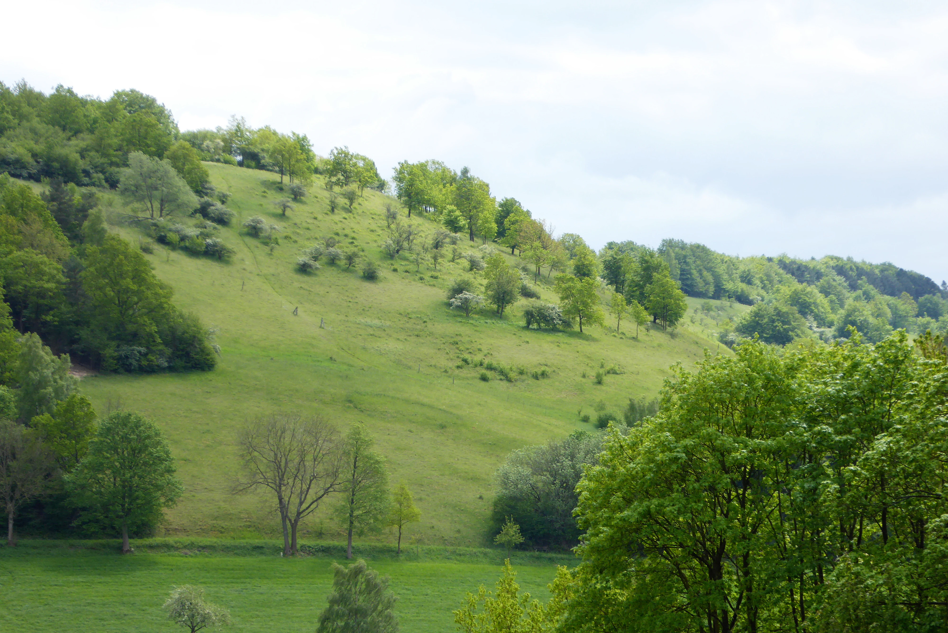
A green grassy hillside slope featuring patches of scattered trees and forest edges under an overcast sky.
A view of the calcareous grassland slopes at Weper, characterized by open meadows interspersed with deciduous trees.

Weper, Gladeberg und Aschenburg history and protected-area timeline

The conservation story of Weper, Gladeberg und Aschenburg begins with the original Weper nature reserve, which was established in 1981 and covered roughly 200 hectares of grassland and forest on the Weper ridge between Fredelsloh and Trögen. This earlier designation recognized the long-known botanical richness of the calcareous hilltops but applied only to a single coherent area, leaving neighboring sites such as the Gladeberg, Heineberg, and Aschenburg under less formal protection.

Ecological survey work and the European Habitats Directive (Fauna-Flora-Habitat-Richtlinie) brought a broader regional perspective. The entire landscape mosaic of Weper, Gladeberg, and Aschenburg was designated as a single 842-hectare FFH area, formalizing its importance at the European level for habitats such as calcareous grasslands and species-rich beech forests. As this larger framework matured, it became clear that tighter domestic protection, including a unified national nature reserve designation covering all relevant fragments, would be more effective than the older single-site approach.

On 14 May 2020, the new nature reserve Weper, Gladeberg und Aschenburg (NSG BR 054, approximately 267 hectares across five sub-areas) was formally designated under Lower Saxon nature conservation law, absorbing the earlier 1981 Weper reserve. The reconfigured reserve ensures contiguous management across the combined site, coordinated by the responsible lower nature conservation authorities of the Northeim and Göttingen districts, and reinforces the ecological link to the surrounding landscape protection zone.

Weper, Gladeberg und Aschenburg landscape and geographic character

The protected area sits in the gently rolling hill country of southern Lower Saxony, northwest of Göttingen. The terrain is shaped by limestone and calcareous substrate, producing the shallow, well-drained soils that underpin both the grassland and forest communities. The reserve is not a single continuous tract but a mosaic of separate but ecologically linked hilltop and slope fragments.

On the Weper ridge between Fredelsloh and Trögen, the land forms a long, prominent elevation with open south-facing slopes and wooded upper sections. The Heineberg, northeast of Fredelsloh, is a more compact hill with similar calcareous character, while the Gladeberg south of Hardegsen and the Aschenburg west of Harste add further isolated hilltop elements to the reserve. Together these features create a network of dry, sun-exposed surfaces separated by forested valleys and agricultural land.

The semi-dry grasslands occupy the warmer, thinner-soiled slopes and plateau edges, while the near-natural beech and oak-hornbeam forests occupy the cooler, deeper-soiled slopes and shaded valleys. The transition between open grassland, shrub fringe, and closed forest is often abrupt, generating the small-scale mosaic that supports the reserve's biological richness. The five sub-areas are embedded in a wider landscape protection zone, which functions as a connective buffer and conservation corridor around the strictly protected core.

Weper, Gladeberg und Aschenburg ecosystems, habitats, and plant life

Ecologically, the nature reserve is notable for the close coexistence of two distinct but mutually reinforcing habitat types on calcareous substrate: species-rich semi-dry grassland and near-natural broadleaf forest. The grasslands, which dominate the open hilltops and south-facing slopes, belong to the Enzian-Schillergras-Rasen community, a calcareous grassland type that is now rare across much of central Germany due to land-use change.

These Enzian-Schillergras-Rasen are floristically remarkable. They support significant populations of wild orchids, including Lady's Slipper Orchid, several Knabenkraut species such as Military, Three-toothed, and Broad-leaved Orchids, and other notable indicators such as Cross Gentian, Clustered Calamint, Silver Thistle, Moonwort, and a suite of bryophytes and lichens including Fulgensia fulgens, Cladonia foliacea, and Toninia sedifolia. Among the grassland forbs one finds Large Wood Anemone, Common Cat's-ear, and field species such as Acker-Wachtelweizen. Stands of sweet grass (Ruchgras) and meadow cumin occur in associated species-rich meadows.

The forest communities are equally important. Beech forests are represented by woodruff-beechwood and orchid-beechwood forms, dominated by European Beech with admixed Ash, Wild Service Tree, and Norway Maple. Relic oak-hornbeam forests, derived from older coppice and middle-forest management, contain Pedunculate Oak, Sessile Oak, and Hornbeam with site-typical understory including Wild Ginger and Turk's Cap Lily. Across the forested sections there is an unusually high proportion of old and dead wood, providing the structural continuity required by specialist forest species.

Weper, Gladeberg und Aschenburg wildlife and species highlights

The semi-dry grasslands are especially important for butterflies and other insects. Recorded species include Silver-studded Blue, Thyme Blue, Small Blue, Primula Fritillary, and several checker-spot species tied to specific host plants. The related butterfly fauna extends into adjacent meadow and scrub, with species such as the Marbled White and Clouded Yellow taking advantage of flower-rich edges. Reptiles are also present, with Sand Lizard documented among the warmer slope habitats.

The wooded parts of the reserve carry a rich vertebrate fauna. Bats are particularly well represented; the structurally diverse old and dead wood stands provide critical roosting habitat, and the site is of particular importance for Greater Mouse-eared Bat. The forests and adjacent open ground support numerous raptors and woodpeckers, including Red Kite and Grey-headed Woodpecker, alongside other cavity-nesting species that benefit from the abundant veteran trees.

Of particular conservation interest is the documented presence of two of Europe's rarest forest carnivores: Eurasian Lynx and Wildcat. These wide-ranging species rely on large, undisturbed forest blocks and indicate that the broader forested landscape surrounding the core reserve remains ecologically functional at a regional scale. Their presence, together with the deadwood-rich forest structure and the high butterfly and orchid diversity in the grasslands, gives the reserve an unusually complete picture of calcareous-hill biodiversity.

Weper, Gladeberg und Aschenburg conservation status and protection priorities

Weper, Gladeberg und Aschenburg sits at the intersection of national and European conservation frameworks. As a designated Lower Saxon Naturschutzgebiet under the code NSG BR 054, it carries domestic legal protection aimed at preserving its habitats, species, and ecological processes against damaging change. As a component of an FFH-Gebiet of the same name, the site is also part of the European Natura 2000 network, which obliges authorities to maintain or restore the favorable conservation status of listed habitat types and species.

The ecological value of the reserve lies in the conservation of habitats that have become strongly depleted across central Germany. Calcareous semi-dry grasslands of the Enzian-Schillergras-Rasen type have declined dramatically with the abandonment of traditional grazing and the intensification of land use; protecting and actively managing remaining fragments is therefore a central conservation task. The site's orchid-rich grassland flora and associated butterfly community make it a particularly important reservoir for the regional conservation of these communities.

The forest component is similarly significant. The near-natural beech and oak-hornbeam stands with abundant old and dead wood correspond to high-priority European habitat types, supporting specialist bats, saproxylic invertebrates, and forest interior-breeding birds. The presence of lynx and wildcat adds a landscape-scale dimension, linking local habitat quality to broader efforts to maintain viable populations of these species across the central German hill country.

Management of the grasslands is carried out through grazing with sheep and goats, a traditional practice that helps preserve the open character of the calcareous sward and prevents succession toward scrub and woodland. The five sub-areas are linked to a surrounding Landschaftsschutzgebiet, which provides a buffer and contributes to functional connectivity at the broader landscape scale.

Weper, Gladeberg und Aschenburg cultural meaning and human context

While the reserve does not center on a particular monument or settlement, its landscape carries a strong cultural resonance rooted in centuries of pastoral land use. The Enzian-Schillergras-Rasen and associated species-rich meadows are relics of an older, extensive grazing economy in which sheep, goats, and cattle moved across the limestone hilltops under systems of common pasturage and Hutung rights. Such landscapes are now rare in central Germany and carry significant ecological as well as cultural-historical value.

The forests of oak-hornbeam on parts of the reserve reflect older woodland management traditions. Many of these stands derive from former coppice-with-standards (Niederwald) and middle-forest (Mittelwald) systems, in which regular cutting cycles and the retention of standard trees shaped a particular species mixture and structure. The persistence of these silvicultural patterns in the present forest composition is itself a record of regional land-use history.

The cultural landscape also includes the surrounding villages and small towns such as Fredelsloh, Trögen, Hardegsen, Moringen, and Harste, whose agricultural economies are tied to the same hill country that the reserve now protects. The continued use of sheep and goat grazing as a management tool in the reserve can be understood as a continuity with, rather than a break from, this longer land-use tradition.

Top sights and standout views in Weper, Gladeberg und Aschenburg

Weper, Gladeberg und Aschenburg stands out for the unusually dense concentration of biodiversity housed in a relatively small but well-structured protected area, with both limestone grassland and near-natural broadleaf forest represented in close proximity.

Highlights include the nationally significant orchid flora and butterfly fauna of the Enzian-Schillergras-Rasen, the deadwood-rich beech and oak-hornbeam forests that support Greater Mouse-eared Bat and a wide bat assemblage, and the confirmed presence of two of Europe's elusive forest predators, Eurasian Lynx and Wildcat, in a landscape otherwise defined by small-scale hilltop fragments.

Best time to visit Weper, Gladeberg und Aschenburg

Late spring through summer is the most rewarding period for visiting the reserve, when the calcareous grasslands come into full flower and the orchid and butterfly fauna is most active. Late May and June typically bring the main orchid display, including Lady's Slipper Orchid and the various Knabenkraut species, together with peak activity for many of the grassland butterflies such as Silver-studded Blue and the various fritillaries and blues.

Early summer also suits exploration of the meadow and scrub transitions, where tall-herb fringes and thorny shrub communities of hawthorn and blackthorn support additional flower and insect interest. The forest sections are attractive across a broader season, with the interplay of mature beech, oak, and hornbeam canopy most appreciated in late spring and early autumn, when the woodland herbs and light conditions on the slopes are most expressive.

Monthly climate preview

Long term representative temperature and precipitation averages recorded at the coordinate sample

Weper, Gladeberg und Aschenburg Climate Normals and Monthly Weather Patterns

Representative baseline measurements for Weper, Gladeberg und Aschenburg trace an annual temperature range spanning from sub zero winter lows to warm summer maximums alongside consistent daily precipitation. Detailed twelve month climatology records provide complete statistical context for analyzing long term environmental conditions across the protected terrain.
Annual mean8 °C
-1 °C18 °C
Jan-1°
Feb
Mar
Apr
May12°
Jun16°
Jul18°
Aug18°
Sep14°
Oct
Nov
Dec
Warmest month
July

18.2 °C

Coolest month
January

-0.9 °C

Wettest month
July

2.6 mm/day

Driest month
April

1.5 mm/day

Park location guide

Geography guide, regional context, and park location map for Weper, Gladeberg und Aschenburg

Weper, Gladeberg und Aschenburg park geography, regions, and map view in Germany

Understand where Weper, Gladeberg und Aschenburg sits in Germany through a broader geographic reading of the surrounding landscape, nearby location context, and its mapped position within the national park landscape.

How Weper, Gladeberg und Aschenburg fits into Germany

Germany is a federal republic in Western and Central Europe with a population of over 83 million across sixteen constituent states. It is Europe's largest economy by nominal GDP and a major global exporter and importer. The capital is Berlin, and the country borders Denmark, Poland, Czech Republic, Austria, Switzerland, France, Luxembourg, Belgium, and the Netherlands.

Wider geography shaping Weper, Gladeberg und Aschenburg in Germany

Germany is located in Western and Central Europe, spanning 357,022 km². It borders Denmark to the north, Poland and the Czech Republic to the east, Austria and Switzerland to the south, and France, Luxembourg, Belgium, and the Netherlands to the west. The country has coastlines on the Baltic Sea and North Sea to the north, with the Alps located in the southern region.

Map view of Weper, Gladeberg und Aschenburg

Use this park location map to pinpoint Weper, Gladeberg und Aschenburg in Germany, understand its exact geographic position, and read its mapped placement within the surrounding landscape more clearly.

Pigeon | © OpenStreetMap contributors

Location context for Weper, Gladeberg und Aschenburg

Lower Saxony

Visual exploration of calcareous grasslands, ridge habitats, and deciduous forest terrain.

Weper, Gladeberg und Aschenburg Photos, Scenery, and Protected Landscape Views

Photographic records reveal the distinct hill fragments, limestone slopes, and fragmented woodland reserves defining the terrain of Weper, Gladeberg und Aschenburg. Visual documentation offers direct insight into the mosaic of semi-natural habitats and conservation zones characterizing the protected area.

A green grassy hillside slope featuring patches of scattered trees and forest edges under an overcast sky.

Park atlas

Compare surrounding hilltop reserves, deciduous forests, and connected landscapes

Parks Near Weper, Gladeberg und Aschenburg and Protected Areas in the Region

Compare Weper, Gladeberg und Aschenburg with other protected areas located across the southern Lower Saxony uplands. Geographic comparison helps trace related limestone reserves, forest fragments, and regional conservation networks.
Nature reserveLower Saxony
About 3.3 km away#1 closest

Southwest

Wald am Großen Streitrodt bei Delliehausen: Protected Beech Forests of Lower Saxony

Geographic overview of the eastern Solling upland nature reserve

The Wald am Großen Streitrodt bei Delliehausen nature reserve protects a rich, near-natural beech woodland matrix in the eastern Solling. Spanning gentle ridges and slopes, the area features significant deadwood habitats and a distinct southeastern meadow mosaic carved by the Kobbeke headwaters. This record details the park landscape and ecological boundaries within the broader forested context of southern Lower Saxony.

Area
228 km²
Established
2020
Nature reserveLower Saxony
About 4 km away#2 closest

Northwest

Wälder im Solling bei Lauenberg Nature Reserve: Geographic and Landscape Analysis

Protected oak pasture remnants in the Lower Saxony Solling

Analyze the mapped parcels of Wälder im Solling bei Lauenberg. This protected site integrates old growth oak forest with open meadows and brook corridors, showcasing the unique cultural and ecological legacy of the Solling region in southern Lower Saxony.

Area
3.22 km²
Established
2020
Nature reserveLower Saxony
About 5.1 km away#3 closest

West

Wälder im östlichen Solling Nature Reserve: Regional Geography and Forest Landscape

Protected beech woodland in the Lower Saxony eastern Solling range

Wälder im östlichen Solling is a specialized nature reserve in the German state of Lower Saxony, covering a vast landscape of broadleaf high forest and historical wood-pasture. This atlas entry focuses on its mapped terrain, featuring mature beech stands, alder-ash spring forests, and intact stream ecosystems along the Riepenbach and Wolfsbach, providing a clear view of its ecological boundaries.

Area
14.79 km²
Established
2020
Nature reserveLower Saxony
About 9.4 km away#4 closest

East

Wahrberg Nature Reserve: Geographic Mapping of Limestone Hilltop Protected Landscapes

Examining the ecological terrain within the Weser-Leine hill country of Lower Saxony

Wahrberg is a protected nature reserve defined by its limestone bedrock and rare calcareous dry grassland habitats. This site serves as a vital ecological refuge, showcasing a mosaic of open slopes, shrub transitions, and broadleaf woodland near the Leine valley. Explore the mapped boundaries and natural terrain characteristics that distinguish this important German nature reserve.

Area
0.25 km²
Established
1991
IUCN
IV
Nature reserveLower Saxony
About 11 km away#5 closest

East

Wasservogelreservat Northeimer Seenplatte Protected Nature Reserve and Wetland Mapping

A floodplain lake mosaic within the Lower Saxony river valley landscape

Wasservogelreservat Northeimer Seenplatte encompasses roughly 80 hectares of protected wetland in Lower Saxony. This nature reserve features a distinct series of gravel-pit lakes framed by agricultural grasslands, serving as a vital sanctuary for migratory and breeding waterbirds. The terrain represents a focused ecological complex positioned within the Leine floodplain, defined by its historical industrial origins and current conservation status.

Area
0.8 km²
Established
1984
IUCN
IV
Relief
Lowland
Nature reserveLower Saxony
About 13 km away#6 closest

Southwest

Wälder am Schäferstein und am Hohen Rott bei Verliehausen: Protected Nature Reserve Landscape

Ancient woodland geography in the Southern Solling uplands

A significant nature reserve in Lower Saxony, these forest tracts at Schäferstein and Hohen Rott protect near-natural beech and oak stands. The site is characterized by an exceptional density of deadwood and historical relict oak pastures, serving as a vital sanctuary for specialized saproxylic beetles and cavity-nesting birds within the broader Solling ridge system.

Area
1.02 km²
Established
2020
Relief
Mountain
Climate
Temperate
A soft watercolor painting depicting a gentle, winding river flowing through a forested landscape with rolling hills in the background.
Protected landscapeLower Saxony
About 13 km away#7 closest

West

Naturpark Solling-Vogler Protected Landscape: Regional Geography and Mapped Terrain

Extensive forested low-mountain region in Lower Saxony

Naturpark Solling-Vogler acts as a core protected region within the Weserbergland of Lower Saxony. This atlas entry details its dual landscape identity, bridging the wide upland Solling plateau with the sharp, narrow Vogler ridge. Explore the mapped river valleys and woodland habitats that define this important German nature park.

Relief
Mountain
Climate
Temperate
Scope
Terrestrial
Water
Major water bodies
Nature reserveNiedersachsen
About 19 km away#8 closest

West

Wälder im südlichen Solling Nature Reserve: A Detailed Atlas of German Protected Woodlands

Ecological mapping of Niedersachsen's southern Solling forest complexes.

Navigate the protected boundaries and landscape character of Wälder im südlichen Solling. This nature reserve provides an essential study in forest conservation, highlighting the intersection of traditional wood-pasture management and steep, near-natural slope forest ecosystems within the Solling-Vogler upland.

Area
10.16 km²
Established
2020
Relief
Upland
Climate
Temperate

Common questions about visiting, size, designation, and location context for Weper, Gladeberg und Aschenburg

Weper, Gladeberg und Aschenburg FAQs for park facts, access, geography, and protected area context

Find quick answers about Weper, Gladeberg und Aschenburg, including protected-area facts, park geography, trail and visitor context, and how the park fits into its surrounding country and regional landscape.
MoriAtlas Explorer

Continue Your Protected Areas Search Across the Global Atlas

Deepen your exploration by continuing the structured search for national parks and protected areas worldwide. Utilize the comprehensive filtering capabilities to compare different conservation landscapes and refine your understanding of global park geography. Discover more about the distribution and characteristics of protected natural areas.

Global natural geography