
Mori Atlas logo
Protected landscapeWernau (Neckar)

A regional atlas exploration of meadow orchards, stream corridors, and cultural terrain

Wernau (Neckar) Protected Landscape: Mapped Geography in the Swabian Alb Foothills of Germany

(Landschaftsschutzgebiet "Wernau (Neckar)")

Wernau (Neckar) comprises six distinct protected sections surrounding the town of Wernau within the Landkreis Esslingen district. This landscape preservation area sits at the vital transition between the Middle Swabian Alb foothills and the Filder plain. Discover the mapped distribution of its traditional orchard meadows, hedgerows, and field copses that form an interconnected habitat network along the Neckar valley corridors.

landscape protection areaSwabian Alb foothillsmeadow orchardscultural landscapehedgerows and field copsesriparian habitat
A graphic illustration depicting a valley with steep rocky cliffs on both sides, waterfalls, a winding river, and a forest of evergreen trees in the foreground.

Wernau (Neckar)

Protected landscape

Park overview

Structured park overview, official facts, and landscape profile for Wernau (Neckar) Landscape Protection Area

Wernau (Neckar) Landscape Protection Area park facts, protected area profile, and essential visitor context

Review the core facts for Wernau (Neckar) Landscape Protection Area, including designation, size, terrain, visitor scale, habitats, and operating context in one park-focused overview.

About Wernau (Neckar) Landscape Protection Area

Wernau (Neckar) is a protected landscape area, or Landschaftsschutzgebiet, that surrounds the town of Wernau im Neckar in the Landkreis Esslingen in Baden-Württemberg. Covering roughly 214 hectares across six non-contiguous sections, it represents one of many such designations in this part of southwestern Germany, where the Swabian Alb drops down toward the Neckar river and the Filder plain. The protected area sits at a transitional zone between the gently rolling foothills of the Alb and the more open agricultural lowlands to the north, giving it a varied mix of terrain, soils, and vegetation.

The defining quality of Wernau (Neckar) is its patchwork structure. Rather than enclosing a single dramatic landscape, it safeguards the everyday countryside around Wernau: extensive traditional meadows, orchard meadows with mature fruit trees, field hedgerows, small copses, streams with accompanying riparian vegetation, and fragments of woodland. These elements are characteristic of the long-standing land use pattern of the region, in which small farms and orchards have shaped the land for centuries. The protected status is intended to keep that mosaic intact, both for its visual and recreational quality and for its ecological function.

Beyond its own boundaries, the area plays a strategic role in the regional conservation network. Parts of it border and act as buffer zones for two existing nature reserves, the Wernauer Baggerseen (gravel pit lakes) and the Wernauer Lehmgrube (clay pit), both of which are ecologically sensitive sites. By limiting further fragmentation and sealing of the surrounding land, the landscape protection area helps maintain habitat continuity and reduces edge effects on these more strictly protected sites.

The area is administered by the Landratsamt Esslingen and falls within the natural regions designated as Mittleres Albvorland and Filder, both components of the broader Schwäbisches Keuper-Lias-Land natural unit. This places the landscape at the meeting point of two distinct geological and ecological zones: the loamy and limestone-influenced foothills, and the flatter, often more fertile Filder plateau. The result is a landscape rich in subtle transitions, where woodland, pasture, orchard, and water features intermingle over short distances.

Quick facts and research context for Wernau (Neckar) Landscape Protection Area

Wernau (Neckar) is a German Landschaftsschutzgebiet (landscape protection area) located in the Landkreis Esslingen in Baden-Württemberg, in southwestern Germany. It is classified as IUCN Category V, Protected Landscape/Seascape, and is administered by the Landratsamt Esslingen.

The protected area covers roughly 214 hectares distributed across six sub-areas on the municipal territory (Gemarkung) of Wernau. It lies within the natural regions of Mittleres Albvorland (101) and Filder (106), part of the larger Schwäbisches Keuper-Lias-Land natural unit. The current designation dates from 3 May 1995, replacing two earlier landscape protections from 1971.

Protection and recognition

Documented protection records and designation history for Wernau (Neckar)

Wernau (Neckar) Protection Status and International Recognition Data

Examine the verified protection status and recorded administrative framework associated with Wernau (Neckar). Official database records compile international recognition details and designation metrics to support accurate environmental research.

Protection details

WDPA ID
325774
Park context

Deeper park guide and search-rich context for Wernau (Neckar) Landscape Protection Area

Wernau (Neckar) Landscape Protection Area history, landscape, wildlife, and travel context

Explore Wernau (Neckar) Landscape Protection Area through its history, landscape character, ecosystems, wildlife, conservation priorities, cultural context, and seasonal travel timing in a structured park guide built for atlas discovery and search intent.

Why Wernau (Neckar) Landscape Protection Area stands out

Wernau (Neckar) is best known as a representative example of the small-scale, near-natural cultural landscape typical of the Swabian Alb foothills, where meadows, orchards, hedgerows, stream corridors, and small woodlands form an interconnected habitat network. The protected area is also notable for its role as a buffer zone around the Wernauer Baggerseen and Wernauer Lehmgrube nature reserves, giving it added ecological importance beyond its own boundaries. Together, these features underline the area's value for both biodiversity conservation and local recreation on the edge of a densely populated region of Baden-Württemberg.
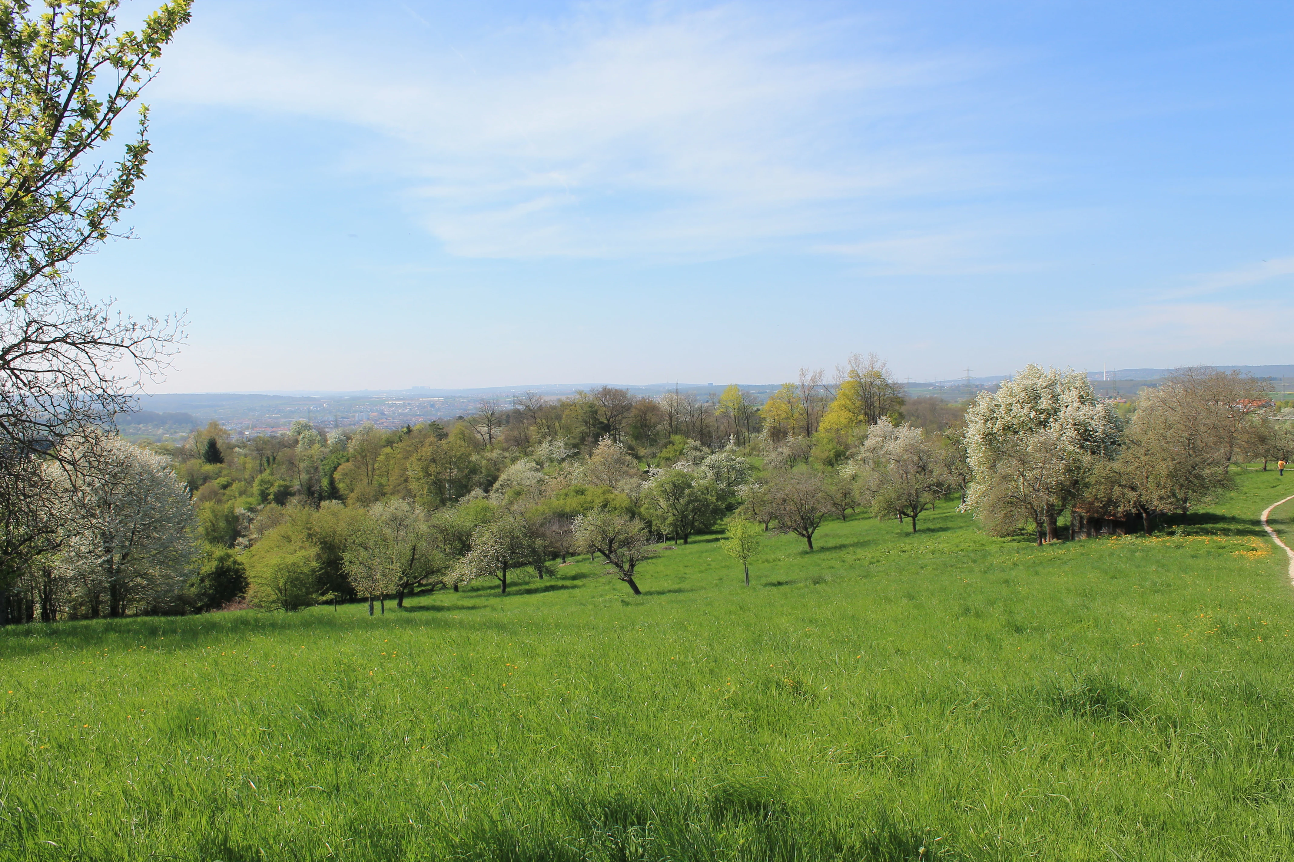
A wide view of a green meadow dotted with flowering trees and orchards, with a hint of a dirt path on the right and a blue sky above.
A meadow orchard landscape with spring blossoms, overlooking the area towards Wernau.

Wernau (Neckar) Landscape Protection Area history and protected-area timeline

Parts of what is today the Wernau (Neckar) landscape protection area have been under landscape protection since 1971. Two earlier designations, Landschaftsschutzgebiet Laichlewald (established 30 November 1971) and Landschaftsschutzgebiet Sulzbachtal (established 15 December 1971), covered important sections of the area in the decades before the present scheme was created.

On 3 May 1995, the Landratsamt Esslingen issued a new, unified protection order consolidating these earlier protections and extending the protected landscape to roughly 214 hectares across six sub-areas. With this consolidation, the older Laichlewald and Sulzbachtal orders ceased to apply as separate designations. The new framework brought the entire area under a single coherent protective regime, simplifying administration and aligning the boundaries with the broader network of nature reserves and protected landscapes around Wernau.

Wernau (Neckar) Landscape Protection Area landscape and geographic character

The protected landscape is built around the gentle topography of the Swabian Alb foothills and the transition toward the Filder plain. Elevations are moderate, and the terrain rolls softly between small valleys, stream corridors, and slightly elevated ridges. Because the protection area is divided into six sections that ring the town of Wernau, the landscape changes repeatedly from one sub-area to another, alternating between open ground, orchard, hedgerow, and woodland.

Water features shape much of the visual character. Small streams and their accompanying riparian vegetation, along with ponds and former extraction sites, create corridors of wet ground and dense vegetation that contrast with the drier meadows and arable land elsewhere. Meadow orchards (Streuobstwiesen), with their scattered mature fruit trees, are among the most distinctive visible elements, lending the countryside its traditional Swabian rural character.

Hedgerows, field copses, and small woodland stands break up the open land and contribute to the closed, near-natural impression of the area. Near the southern edge of the protection area, the Neckar valley forms a broader geographical frame, while the northern parts blend into the wider agricultural Filder landscape.

Wernau (Neckar) Landscape Protection Area ecosystems, habitats, and plant life

The ecological value of Wernau (Neckar) lies in the diversity of habitats packed into a relatively small area. Meadows, orchard meadows, hedgerows, riparian vegetation along small watercourses, field copses, and fragments of woodland together create a fine-grained mosaic of complementary habitat types. Each element supports different species groups, and the proximity of these habitats allows ecological exchange and seasonal movement of plants and animals.

Meadow orchards are a particularly important habitat component in this region, hosting insects, cavity-nesting birds, bats, and a rich understorey of wildflowers in old, extensively managed grassland. Hedgerows and small woodlands offer shelter and breeding sites for birds and small mammals, while the riparian strips along streams provide linear habitats for amphibians, insects, and moisture-loving plants.

Because the protection area adjoins the Wernauer Baggerseen and Wernauer Lehmgrube nature reserves, the protected landscape also serves as a buffer and connective zone between these core sites. This functional role increases the overall ecological coherence of the area, supporting species that require both core protected habitat and intact surrounding countryside.

Wernau (Neckar) Landscape Protection Area wildlife and species highlights

The mosaic of meadows, orchard meadows, hedgerows, streams, and woodlands supports a varied community of typical Swabian Alb foothill wildlife. Meadow orchards in particular provide breeding habitat for numerous bird species and an important foraging resource for insects, while old fruit trees often contain cavities used by owls, woodpeckers, and bats.

Hedgerows, field copses, and small woodlands offer shelter, breeding sites, and travel corridors for small mammals and woodland birds. The riparian zones along streams support amphibian species as well as a range of aquatic and semi-aquatic insects. The protection order explicitly notes that the landscape elements serve as important refuges for a number of plant and animal species, some of which are considered threatened at the regional level.

The adjoining gravel pit lakes and clay pit of the Wernauer nature reserves add aquatic and shoreline habitats that complement the surrounding landscape, supporting waterbirds and other fauna that benefit from the transition between open water and structured terrestrial habitat.

Wernau (Neckar) Landscape Protection Area conservation status and protection priorities

Wernau (Neckar) is classified under the IUCN framework as a Category V Protected Landscape/Seascape, reflecting its emphasis on maintaining a harmonious relationship between traditional land use and natural features rather than on strict nature reserve level protection.

The official protection order identifies multiple conservation goals. The primary aim is to preserve meadows, orchard meadows, hedgerows, water features, riparian and field copses, and woodlands as living landscape elements of high ecological and aesthetic value. These are recognized as important habitats and refuges for many plant and animal species, some of them threatened, and as elements that contribute to the functioning of the natural balance of the region.

A second major goal is to maintain these areas as accessible local recreation landscapes, where people can experience near-natural countryside close to an urbanized region. The order also stresses the role of the protected landscape as a buffer around the Wernauer Baggerseen and Wernauer Lehmgrube nature reserves, helping to shield those sites from harmful land use changes on their edges.

Finally, the protection order explicitly seeks to prevent the further spread of small buildings and enclosures into the countryside. By keeping the open, near-natural character of these peripheral areas intact, the designation helps maintain climate regulation, landscape permeability, and the visual and ecological integrity of the transitional zone between town and surrounding agricultural land.

Wernau (Neckar) Landscape Protection Area cultural meaning and human context

The landscape preserved at Wernau (Neckar) reflects centuries of small-scale farming, fruit growing, and pastoral land use in the foothills of the Swabian Alb. Meadow orchards (Streuobstwiesen) are an especially prominent cultural feature, traditionally used both for fruit production and for hay harvesting beneath the trees, a practice that has long shaped the appearance of Swabian rural landscapes.

Hedgerows, field copses, and small woodlands are likewise products of historical land management, marking old field boundaries, property lines, and farmsteads. Together these elements give the area a strong sense of local identity, even as the town of Wernau itself has grown as a residential and industrial community in the Neckar valley. The protection area thus preserves not only habitats but also a recognizable piece of regional cultural landscape.

Top sights and standout views in Wernau (Neckar) Landscape Protection Area

Wernau (Neckar) stands out for the coherence and diversity of its small-scale habitat mosaic, in which meadow orchards, hedgerows, riparian vegetation, and small woodlands are tightly interwoven around the town of Wernau. The protection area's role as a buffer around the Wernauer Baggerseen and Wernauer Lehmgrube nature reserves adds a strategic conservation dimension beyond the site itself.

At the same time, the area is a working countryside, valued for local recreation and aesthetic enjoyment just as much as for biodiversity. Its position at the transition between the Swabian Alb foothills and the Filder plain gives it both ecological variety and a strong regional cultural identity grounded in traditional Swabian land use.

Best time to visit Wernau (Neckar) Landscape Protection Area

As a cultural landscape composed largely of meadows, orchards, hedgerows, and woodland, Wernau (Neckar) has a strong seasonal character. Late spring brings fresh green growth, flowering meadow flora, and active birdlife, while early summer is the most visually striking period for orchard meadows, when fruit trees are in full leaf and grassland beneath them is at its richest.

Autumn is notable for ripening fruit in the orchard meadows and for the changing colors of woodland and hedgerow vegetation. Winter, when leaves have fallen, exposes the structure of hedgerows and field copses and offers clearer views across the open ground. Soft ground conditions typical of the region's climate may make some paths less comfortable in wetter winter months.

Monthly climate preview

Measured annual temperature progression and precipitation rhythm for Wernau (Neckar)

Wernau (Neckar) Climate Normals and Long-Term Weather by Month

Representative coordinates record long-term average temperature and daily precipitation patterns across twelve monthly periods in Wernau (Neckar). Examining the full climate profile reveals detailed monthly fluctuations in thermal ranges and moisture distribution.
Annual mean8 °C
-1 °C18 °C
Jan-1°
Feb
Mar
Apr
May13°
Jun16°
Jul18°
Aug18°
Sep14°
Oct
Nov
Dec
Warmest month
July

18.2 °C

Coolest month
January

-1.1 °C

Wettest month
July

3.2 mm/day

Driest month
February

1.7 mm/day

Park location guide

Geography guide, regional context, and park location map for Wernau (Neckar) Landscape Protection Area

Wernau (Neckar) Landscape Protection Area park geography, regions, and map view in Germany

Understand where Wernau (Neckar) Landscape Protection Area sits in Germany through a broader geographic reading of the surrounding landscape, nearby location context, and its mapped position within the national park landscape.

How Wernau (Neckar) Landscape Protection Area fits into Germany

Germany is a federal republic in Western and Central Europe with a population of over 83 million across sixteen constituent states. It is Europe's largest economy by nominal GDP and a major global exporter and importer. The capital is Berlin, and the country borders Denmark, Poland, Czech Republic, Austria, Switzerland, France, Luxembourg, Belgium, and the Netherlands.

Wider geography shaping Wernau (Neckar) Landscape Protection Area in Germany

Germany is located in Western and Central Europe, spanning 357,022 km². It borders Denmark to the north, Poland and the Czech Republic to the east, Austria and Switzerland to the south, and France, Luxembourg, Belgium, and the Netherlands to the west. The country has coastlines on the Baltic Sea and North Sea to the north, with the Alps located in the southern region.

Map view of Wernau (Neckar) Landscape Protection Area

Use this park location map to pinpoint Wernau (Neckar) Landscape Protection Area in Germany, understand its exact geographic position, and read its mapped placement within the surrounding landscape more clearly.

Pigeon | © OpenStreetMap contributors

Location context for Wernau (Neckar) Landscape Protection Area

Baden-WürttembergLandkreis Esslingen

Explore protected habitats, traditional orchards, and terrain across the Swabian Alb foothills.

Wernau (Neckar) Landscapes and Scenery: Visual Park Photography

Visual records illustrate the protected landscape character, orchard mosaics, and stream corridors defining Wernau (Neckar). Photographic views reveal the terrain, habitat diversity, and cultural countryside surrounding the northern Neckar valley.

A wide view of a green meadow dotted with flowering trees and orchards, with a hint of a dirt path on the right and a blue sky above.

Park atlas

Compare adjacent conservation zones and regional cultural terrain across Baden-Württemberg.

Parks Near Wernau (Neckar) and Protected Landscapes in the Surrounding Region

Browsing other protected areas near Wernau (Neckar) reveals connected habitats and traditional agricultural mosaics across the Swabian Alb foothills. Expanding the geographic comparison highlights related regional landscapes and broader conservation patterns throughout the surrounding valley.
Protected landscapeBaden-Württemberg
About 4.2 km away#1 closest

West

Unteres Körschtal Protected Landscape: Geography and Mapped Boundaries in Baden-Württemberg

An ecological green corridor within the Swabian Keuper-Lias landscape

Unteres Körschtal protects the natural valley floor and adjacent slopes of the lower Körsch river. This landscape conservation area provides essential habitat and recreational space between the Filder plateau and the Neckar valley, standing as a primary example of regional geography in Germany.

Area
4.729 km²
Established
1978
IUCN
V
Protected landscapeBaden-Württemberg
About 4.5 km away#2 closest

South

Wendlingen am Neckar Protected Landscape: Regional Geography and Habitat Connectivity

A structured Swabian countryside mosaic in Baden-Württemberg

This protected area safeguards a unique, fragmented landscape comprising traditional orchard meadows and brookside woodland corridors. Located on the Filder plateau, it acts as a critical ecological refuge, maintaining the transition between settled zones and the natural terrain of the Mittleres Albvorland through long-standing landscape conservation measures.

Area
2.27 km²
Established
1992
IUCN
V
Protected landscapeBaden-Württemberg
About 6.7 km away#3 closest

Southeast

Notzingen Protected Landscape: Mapping the Voralb Foothills and Swabian Alb Terrain

Regional protected area analysis in Landkreis Esslingen

Notzingen represents a coherent protected landscape composed of three parcels near the Swabian Alb foothills. The area is defined by a delicate intersection of stream-side riparian habitats and traditional Streuobstwiesen orchard meadows. This atlas-focused entry provides spatial context for understanding how these protected lands maintain the character of the southern German countryside.

Area
3.15 km²
Established
1989
IUCN
V
Relief
Upland
A minimalist watercolor painting depicting a soft-focus landscape with rolling hills, distant ridgelines, and scattered trees across a meadow, rendered in muted greens, purples, and pinks on a white background.
Protected landscapeBaden-Württemberg
About 11 km away#4 closest

Southeast

Ohmden-Holzmaden Protected Landscape: Swabian Alb Foothill Mapping

A diverse mosaic of traditional orchards and stream valleys

Ohmden-Holzmaden encompasses a vital protected landscape in the Esslingen district, defined by the Trinkbach, Seebach, and Aubach valleys. This geography of traditional orchards, meadows, and hedgerows maintains an open, structured rural habitat that serves as a critical refuge within the broader Swabian Alb foothill region of Germany.

Area
3.111 km²
Established
1993
IUCN
V
Relief
Upland
Protected landscapeBaden-Württemberg
About 11 km away#5 closest

South

Tiefenbachtal Protected Landscape: Geographic Boundaries and Regional Terrain Map

Swabian Alb foothill mosaic in the Esslingen district

Investigate the protected landscape of Tiefenbachtal, where gently rolling terrain and stream-cut valleys form a continuous ecological corridor. This record covers the physical geography, meadow and woodland composition, and the broader context of this site within the Baden-Württemberg pre-Alb landscape.

Area
0.35 km²
Established
1958
IUCN
V
Relief
Upland
A watercolor painting showing a soft green landscape with rolling hills, a distant mountain range, and flowering trees.
Protected landscapeBaden-Württemberg
About 12 km away#6 closest

East

Nassachtal Protected Landscape: Geographic Overview and Mapped Terrain in Baden-Württemberg

Conservation geography of the Nassach stream catchment area.

Covering the full extent of the Nassach valley in southwestern Germany, this protected landscape serves as a critical ecological link between forest and agricultural zones. The terrain encompasses a typical Swabian hill country profile with incised stream valleys and wooded ridges, securing natural continuity across the Schurwald and Welzheimer Wald regions.

Area
21.666 km²
Established
1982
IUCN
V
Relief
Upland
A pale watercolor landscape illustration showing rolling green hills and meadows under a soft yellow sky.
Protected landscapeBaden-Württemberg
About 13 km away#7 closest

South

Owen Protected Landscape: A Geographic Analysis of Orchard Meadows and Teckberg Terrain

Baden-Württemberg protected area and regional landscape map

Examine the detailed landscape composition of the Owen protected area, a vital reserve in the Mittleres Albvorland. This atlas entry focuses on the interaction between traditional orchard meadow mosaics, hedgerows, and the abrupt topographical shift toward the Teckberg peak, providing a clear geographic context for this protected natural region.

Area
5.67 km²
Established
1974
IUCN
V
A horizontal watercolor painting showing soft, rounded green hills and a treeline against a pale background.
Protected landscapeBaden-Württemberg
About 14 km away#8 closest

Northeast

Ottilienberg Protected Landscape: Geomorphological Identity and Regional Mapping

A distinct Keuper outlier hill within Baden-Württemberg

The Ottilienberg protected landscape is a landmark Keuper Zeugenberg situated on the southern outskirts of Schorndorf. This compact area features a striking oak-dominated woodland crest and traditional orchard meadows, serving as a key example of a preserved cultural-historic landscape in southwestern Germany.

Area
0.083 km²
Established
1968
IUCN
V
Relief
Upland

Common questions about visiting, size, designation, and location context for Wernau (Neckar) Landscape Protection Area

Wernau (Neckar) Landscape Protection Area FAQs for park facts, access, geography, and protected area context

Find quick answers about Wernau (Neckar) Landscape Protection Area, including protected-area facts, park geography, trail and visitor context, and how the park fits into its surrounding country and regional landscape.
MoriAtlas Explorer

Continue Your Protected Areas Search Across the Global Atlas

Deepen your exploration by continuing the structured search for national parks and protected areas worldwide. Utilize the comprehensive filtering capabilities to compare different conservation landscapes and refine your understanding of global park geography. Discover more about the distribution and characteristics of protected natural areas.

Global natural geography