
Mori Atlas logo
Nature reserveWeserniederung am Heiligenberg

Understanding the hydrologic and forest geography of this unique German nature reserve

Weserniederung am Heiligenberg: A Mapped Protected Area and Calcareous Spring Landscape

(Naturschutzgebiet Weserniederung am Heiligenberg)

Weserniederung am Heiligenberg is a distinct nature reserve in the Lower Saxony region of Germany, defined by its specialized spring-fed ecosystems and proximity to the Weser river. This protected landscape contains a rare, elongated horizon of active tufa-forming springs and calcareous fens that support diverse invertebrate and bird populations. By examining the local topography, visitors can understand how the transition from river floodplain to forested slopes shapes this compact, high-value conservation area.

nature reserveWeser floodplainWeserberglandcalcareous springsspring mirestufa springs
A stylized illustration of a river winding through a valley with hills, trees, and a distant transmission tower under a soft, golden sky.

Weserniederung am Heiligenberg

Nature reserve

Park overview

Structured park overview, official facts, and landscape profile for Weserniederung am Heiligenberg

Weserniederung am Heiligenberg park facts, protected area profile, and essential visitor context

Review the core facts for Weserniederung am Heiligenberg, including designation, size, terrain, visitor scale, habitats, and operating context in one park-focused overview.

About Weserniederung am Heiligenberg

Weserniederung am Heiligenberg is a compact but ecologically rich nature reserve in the Weserbergland, the rolling, hill-fringed stretch of the middle Weser valley in southern Lower Saxony. It occupies a strip of land between the Weser and the lower slopes of the Heiligenberg northwest of Bodenwerder, a town otherwise better known as the legendary home of Baron Münchhausen. The reserve's small size belies the diversity of habitats it protects: within only a few hectares it combines calcareous spring mires, seepage slopes, mixed deciduous forests, softwood floodplain forest, reed beds, and tall herb floodplain vegetation.

The defining feature of the site is a long, narrow line of springs along the foot of the Heiligenberg, where calcareous groundwater emerges at the surface and deposits tufa. Over time this has created calcareous spring fens (Kalk-Quellmoore) hosting a specialized flora and fauna that would not survive on the surrounding more acidic substrates. The spring waters feed a network of near-natural brooklets that meander through the lower parts of the reserve before reaching the Weser's flood channel system (Flutrinnensystem) in the floodplain.

Forest cover dominates the hillside portions. Oak-hornbeam mixed forest and woodruff beech forest thrive on the moist, base-rich soils here, displaying characteristic species combinations such as pedunculate oak, hornbeam, small-leaved lime, wild cherry, sycamore maple, and beech. In the northwestern part of the reserve, the spring rivulets cut through a patch of alder-ash floodplain forest that is especially rich in old and dead trees, including cavity-bearing individuals that are important for hole-nesting birds and bats. A narrow strip of willow floodplain woodland with fluted elm accompanies parts of the Weser bank itself.

The reserve was designated in 2016 and is now part of both the EU Habitats Directive network, through the FFH site 'Quellsumpf am Heiligenberg', and the EU Birds Directive network through its inclusion in the SPA 'Sollingvorland'. It borders the landscape protection area 'Sollingvorland-Wesertal', creating a larger connected network of protected habitats along the lower Solling foreland and the middle Weser valley.

Quick facts and research context for Weserniederung am Heiligenberg

Weserniederung am Heiligenberg is a nature reserve (NSG HA 225) of about 7.3 hectares in the municipality of Heyen, district of Holzminden, Lower Saxony, located on the lower slopes of the Heiligenberg along the Weser floodplain. It was established on 30 June 2016 and is administered by the Landkreis Holzminden as the lower nature protection authority, with technical oversight from the NLWKN (Niedersächsischer Landesbetrieb für Wasserwirtschaft, Küsten- und Naturschutz).

A 5.97-hectare portion of the reserve is simultaneously designated as the FFH (Habitats Directive) site 'Quellsumpf am Heiligenberg' and largely coincides with the EU Bird Directive (SPA) site 'Sollingvorland'. The reserve's elevation ranges roughly between 72 m and 95 m above sea level and adjoins part of the larger landscape protection area 'Sollingvorland-Wesertal'. Its core conservation value lies in a linear calcareous spring system, calcareous spring mires, floodplain forest, and old-growth trees with significant deadwood.

Protection and recognition

Documented terrestrial protection metrics and official designation records

Weserniederung am Heiligenberg Protection Status and Designation History

Weserniederung am Heiligenberg holds documented terrestrial protection status established in the year 2016. Official records track the formal designation history and management scope associated with this protected area.

Protection details

Protection scope
Terrestrial
Designated year
2016
Transboundary protection
No
WDPA ID
555519318
Park context

Deeper park guide and search-rich context for Weserniederung am Heiligenberg

Weserniederung am Heiligenberg history, landscape, wildlife, and travel context

Explore Weserniederung am Heiligenberg through its history, landscape character, ecosystems, wildlife, conservation priorities, cultural context, and seasonal travel timing in a structured park guide built for atlas discovery and search intent.

Why Weserniederung am Heiligenberg stands out

The reserve is best known for its elongated calcareous spring horizon ('Quellhorizont') with active tufa-forming springs, a relatively rare habitat type in Lower Saxony. These springs have built calcareous spring mires that harbor specialized invertebrates such as the bulgy whorl snail and the striped spring demoiselle. Equally distinctive is the way hydrology, soils, and forest types interact within a very small area: alder-ash gallery forest threaded with spring rivulets gives way to oak-hornbeam and beech forests on the slopes, while the Weser bank carries willow floodplain woodland. The concentration of woodland, wetland, and floodplain elements in one compact site, together with confirmed breeding of black stork and eagle owl, makes the reserve a notable biodiversity hotspot in the otherwise heavily cultivated Solling foreland.
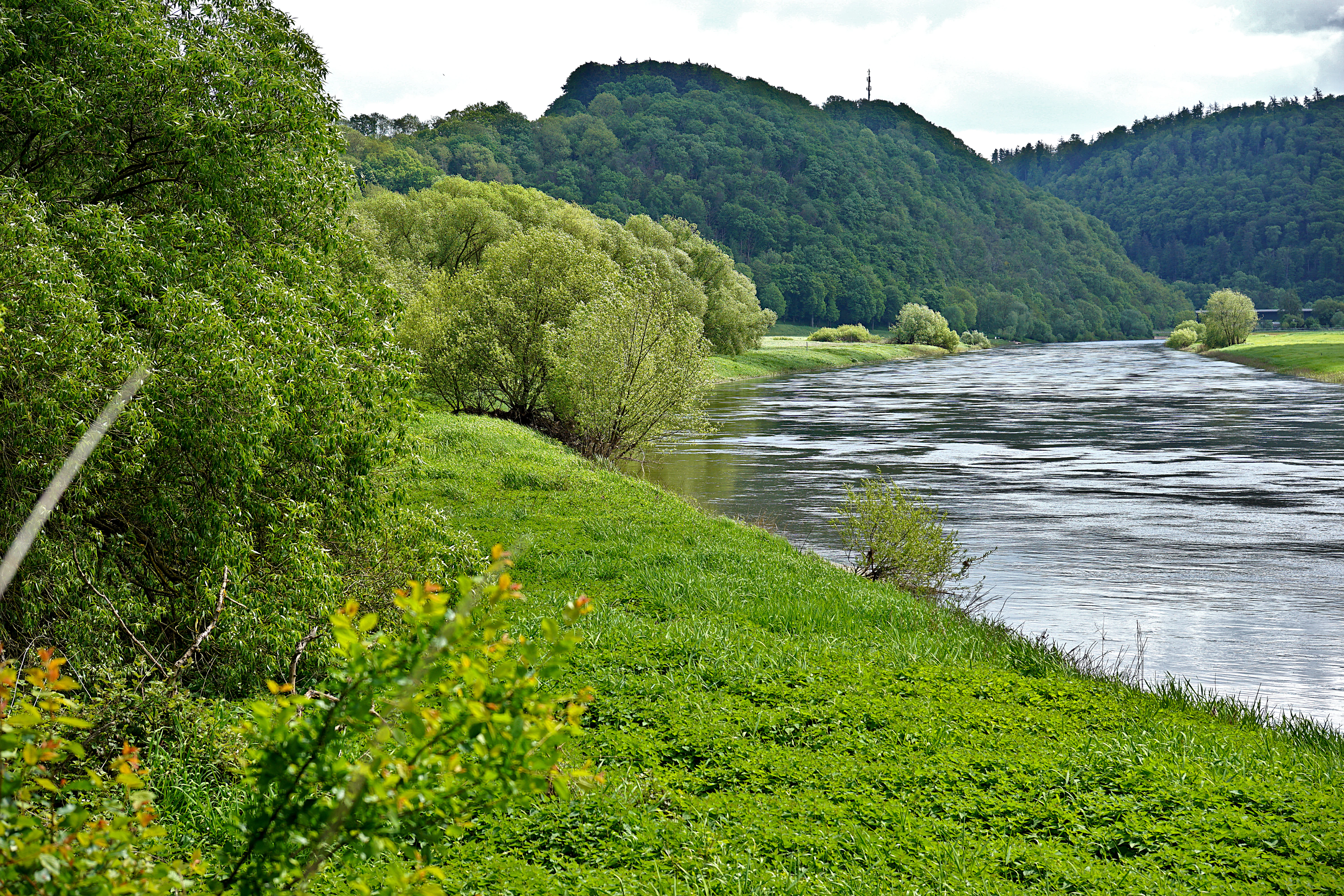
A wide view of the Weser river flowing past green riverbanks and a forested hill in the background.
A scenic view of the Weser river flowing through the Weserniederung am Heiligenberg nature reserve.

Weserniederung am Heiligenberg history and protected-area timeline

The Weserniederung am Heiligenberg received formal nature reserve (Naturschutzgebiet) status under the designation NSG HA 225 on 30 June 2016, with the Landkreis Holzminden acting as the responsible lower nature protection authority. The decision brought together long-existing natural values: a calcareous spring horizon, mature mixed deciduous forests with significant old and deadwood, and floodplain sections along the Weser.

A core portion of the reserve, roughly 5.97 hectares, had already been recognized at the European level as the FFH (Habitats Directive) site 'Quellsumpf am Heiligenberg'. With the 2016 designation, this area was formally embedded into the national nature reserve framework. Most of the FFH section simultaneously forms part of the EU Birds Directive site 'Sollingvorland', integrating the site into both habitat and species protection networks.

Management of the reserve is carried out under the technical oversight of the Niedersächsischer Landesbetrieb für Wasserwirtschaft, Küsten- und Naturschutz (NLWKN). Ongoing measures include regular mowing of the open spring mire areas to keep them free of encroachment, and the long-term conversion of non-typical forest stands into ones composed of species naturally suited to these calcareous, spring-influenced soils.

Weserniederung am Heiligenberg landscape and geographic character

The reserve lies at the transition between the Weser floodplain and the wooded lower slopes of the Weserbergland. Its elevation runs roughly from about 72 m to 95 m above sea level, covering the gentle rise from the Weser bank up the foot of the Heiligenberg. The hill itself, characteristic of the Solling foreland, has its base tucked against the wet lowlands, producing the conditions for the site to capture and discharge groundwater along a distinct spring horizon.

Geomorphologically, the area combines three zones: the active floodplain of the Weser with its natural flood channels along the western edge, the spring-fed seepage belt on the lower slope, and the more consolidated, loamier soils higher up that support taller deciduous forest. The interplay of base-rich spring water, periodic flooding influence from the Weser, and stable forest soils on the slope is what gives the site its unusual habitat diversity within a very small footprint.

Weserniederung am Heiligenberg ecosystems, habitats, and plant life

Ecologically, Weserniederung am Heiligenberg is defined by the calcareous spring system that runs through its center. Along this line, lime-rich groundwater emerges to form actively tufa-depositing springs (Kalktuffquellen) and a chain of calcareous spring mires (Kalk-Quellmoore). These habitats are uncommon in Lower Saxony and are the principal reason the site has been included in the EU Habitats Directive network.

The forest mosaic mirrors the soil and moisture gradient. On the moister, base-rich lower slopes, oak-hornbeam mixed forest with pedunculate oak, hornbeam, and small-leaved lime forms the main cover, accompanied by a shrub and herb layer rich in woodruff, wood anemone, greater stitchwort, hairy melick, and wood melick. Higher on the slope, woodruff beech forest prevails, with beech, ash, sycamore maple, wild cherry, oak, hornbeam, and aspen. Where the spring rivulets feed the valley bottom in the northwest, an alder-ash floodplain forest has developed, characterized by common ash and black alder and notable for its high proportion of old and dead trees, including cavity-bearing individuals.

In the open wetland and floodplain zones, reed beds of common reed and reed canary grass, stands of Himalayan balsam, and tall herb flood meadows with butterbur and hedge bindweed give way to specific wet-indicator species such as narrow-leaved water parsnip and bitter cress. Along the Weser bank, willow-dominated soft floodplain woodland with fluted elm completes the habitat mosaic.

Weserniederung am Heiligenberg wildlife and species highlights

The combination of spring mires, old deciduous forest with deadwood, and floodplain woodland supports a characterful mix of fauna. The calcareous spring mires harbor the bulgy whorl snail (Bauchige Windelschnecke), an indicator of near-natural, lime-rich seepage habitats that has declined across much of central Europe. The striped spring demoiselle (Gestreifte Quelljungfer), a dragonfly of clean, well-vegetated spring brooks, also finds suitable breeding conditions here.

The forest structure, with abundant old and dead trees, makes the reserve important for cavity-nesting species. Confirmed or characteristic breeding birds include eagle owl, black stork, red kite, black kite, grey woodpecker, black woodpecker, and red-backed shrike. Grey herons forage along the floodplain, and the general richness of the Weser floodplain draws additional wading and water-associated species during migration.

Mammals and invertebrates benefit from the continuity and structural diversity of the forest stands, particularly the alder-ash floodplain woodland with its high deadwood component, which provides habitat for saproxylic beetles, bats, and other woodland specialists.

Weserniederung am Heiligenberg conservation status and protection priorities

Conservation significance at Weserniederung am Heiligenberg rests on three overlapping layers. At the national level, the site is a Naturschutzgebiet under the Lower Saxon nature protection framework, with designated management authority and rules on access; the spring mires and their surroundings are kept open through regular mowing to prevent scrub encroachment.

At the European level, the core 5.97-hectare portion is the FFH site 'Quellsumpf am Heiligenberg', recognizing its value as a representative example of calcareous spring mire habitat. Most of this section is also part of the EU Birds Directive site 'Sollingvorland', tying the reserve into the broader protection of bird populations of the Solling foreland. The reserve borders the landscape protection area 'Sollingvorland-Wesertal', extending the effective conservation landscape along the Weser.

A forward-looking management goal is the long-term conversion of forest stands composed of species not naturally suited to these calcareous, spring-influenced soils into more typical, site-appropriate forests, gradually shifting the woodland composition toward the oak-hornbeam, beech, and alder-ash communities that characterize the undisturbed hydrological conditions of the area.

Weserniederung am Heiligenberg cultural meaning and human context

The reserve sits in a landscape shaped by centuries of small-scale agriculture, forestry, and settlement along the middle Weser. The nearby town of Bodenwerder is closely associated with the literary figure of Baron Hieronymus Karl Friedrich von Münchhausen, whose fantastical tales have become a regional cultural hallmark. The Weserbergland more broadly, with its hilltop castles, half-timbered villages, and the river as a historic transport corridor, carries a long tradition of interaction between people and this particular stretch of valley, including watermills, river trade, and forest use.

The presence of officially designated landscape protection areas around the reserve reflects the regional tradition of balancing agricultural land use, forestry, and habitat protection, an approach that has helped maintain smaller, hydrologically sensitive features such as the Heiligenberg spring horizon.

Top sights and standout views in Weserniederung am Heiligenberg

A linear calcareous spring system with active tufa deposition and associated calcareal spring mires, a habitat type that is regionally uncommon and a key reason for European-level protection of the site.

An unusually compact mosaic of oak-hornbeam forest, woodruff beech forest, and alder-ash floodplain forest laced with spring brooks, complemented by willow soft floodplain woodland along the Weser itself.

High structural quality in the floodplain forest, with abundant old and dead trees providing cavity nesting sites for eagle owl, black stork, and woodpeckers, and breeding or foraging habitat for red and black kite, grey heron, and red-backed shrike.

Integration into both the EU Habitats Directive site 'Quellsumpf am Heiligenberg' and the EU Birds Directive site 'Sollingvorland', linking the reserve to wider conservation networks in the Weserbergland.

Best time to visit Weserniederung am Heiligenberg

Spring and early summer are the most rewarding seasons to experience the site, when the calcareal springs and mires are at their most active, the tall herb floodplain vegetation is in full growth, and woodland birds are establishing breeding territories. Late spring is also when many of the characteristic forest herbs, such as wood anemone and greater stitchwort, are at peak display beneath the deciduous canopy.

Autumn offers quieter conditions, the structural richness of the forests with their old and dead trees, and the chance to observe migrating raptors and waterbirds along the Weser. Winter visits can be productive for tracking waterbirds on the river, though the broader impression of the site's character comes through most clearly between April and June, when the interplay of water, woodland, and spring-fed vegetation is most vivid.

Monthly climate preview

Long-term representative temperature and precipitation averages by month

Weserniederung am Heiligenberg Climate Normals and Annual Weather Patterns

Long-term NASA data reveals the measured temperature and precipitation rhythm recorded at a representative point within Weserniederung am Heiligenberg. Reviewing the complete twelve-month climate profile provides deeper context on average monthly conditions across the protected area.
Annual mean9 °C
0 °C18 °C
Jan
Feb
Mar
Apr
May12°
Jun16°
Jul18°
Aug18°
Sep14°
Oct
Nov
Dec
Warmest month
July

17.8 °C

Coolest month
January

0 °C

Wettest month
July

2.6 mm/day

Driest month
April

1.6 mm/day

Park location guide

Geography guide, regional context, and park location map for Weserniederung am Heiligenberg

Weserniederung am Heiligenberg park geography, regions, and map view in Germany

Understand where Weserniederung am Heiligenberg sits in Germany through a broader geographic reading of the surrounding landscape, nearby location context, and its mapped position within the national park landscape.

How Weserniederung am Heiligenberg fits into Germany

Germany is a federal republic in Western and Central Europe with a population of over 83 million across sixteen constituent states. It is Europe's largest economy by nominal GDP and a major global exporter and importer. The capital is Berlin, and the country borders Denmark, Poland, Czech Republic, Austria, Switzerland, France, Luxembourg, Belgium, and the Netherlands.

Wider geography shaping Weserniederung am Heiligenberg in Germany

Germany is located in Western and Central Europe, spanning 357,022 km². It borders Denmark to the north, Poland and the Czech Republic to the east, Austria and Switzerland to the south, and France, Luxembourg, Belgium, and the Netherlands to the west. The country has coastlines on the Baltic Sea and North Sea to the north, with the Alps located in the southern region.

Map view of Weserniederung am Heiligenberg

Use this park location map to pinpoint Weserniederung am Heiligenberg in Germany, understand its exact geographic position, and read its mapped placement within the surrounding landscape more clearly.

Pigeon | © OpenStreetMap contributors

Location context for Weserniederung am Heiligenberg

Lower Saxony

Visualizing the spring horizons, floodplain forests, and rare tufa habitats of Lower Saxony

Weserniederung am Heiligenberg Photos and Scenery: Exploring the Protected Landscape

Visual documentation of Weserniederung am Heiligenberg reveals the intricate mosaic of spring-fed fens, riparian woodlands, and moist deciduous slopes. Examining these protected habitats provides deeper insight into the ecological character and terrain diversity of the Weserbergland floodplain.

A wide view of the Weser river flowing past green riverbanks and a forested hill in the background.

Park atlas

Compare adjacent river floodplains and wooded hill reserves across the Weserbergland

Parks Near Weserniederung am Heiligenberg and Surrounding Regional Protected Areas

Continue exploring regional protected landscapes and river valleys connected to Weserniederung am Heiligenberg. Compare nearby spring habitats, floodplain forests, and woodland reserves across the surrounding territory.
Watercolor painting of a rolling, forested ridge landscape in shades of green, yellow, and soft pink.
Protected areaLower Saxony
About 5 km away#1 closest

Northeast

Ith Protected Area: Mapped Limestone Ridge Geography and Geological Features

Continuous limestone cliff formations in the Lower Saxony uplands

The Ith stands as a major geological landmark in Lower Saxony, featuring a 22 kilometer spine of Upper Jurassic limestone. This protected area preserves a unique collection of cliff crags, dense beech forests, and limestone-dependent plant communities that span the districts of Hameln-Pyrmont and Holzminden.

Relief
Mountain
Climate
Temperate
Access
Access unknown
Scope
Terrestrial
Nature reserveLower Saxony
About 9.9 km away#2 closest

Northeast

Südhang des Thüster Berges: Protected Limestone Landscape and Regional Terrain in Lower Saxony

Nature reserve located in the Weserbergland range

Südhang des Thüster Berges offers a focused look at a sixty-hectare nature reserve defined by steep, sun-exposed limestone slopes. This protected area in Lower Saxony preserves a specialized mosaic of calcareous semi-dry grassland, traditional meadow, and near-natural forest that stands out within the broader, densely forested ridges of the German Weserbergland landscape.

Area
0.6 km²
Established
1989
IUCN
IV
Relief
Mountain
Nature reserveHolzminden
About 13 km away#3 closest

South

Südliche Burgberghänge, Weinberge bei Holenberg und Rühle Nature Reserve and Protected Lands

Geographic atlas and landscape overview in Holzminden

Situated in the Solling foothills, this nature reserve integrates calcareous beech forests and semi-dry grasslands into a singular protected entity. The site highlights complex geological gradients and supports specialized flora and fauna, including rare orchids and woodland birds, within a mosaic of limestone and sandstone terrain near the Bremke brook.

Area
1.77 km²
Established
2020
Relief
Upland
Climate
Temperate
Natural monumentRheinland-Pfalz
About 19 km away#4 closest

North

Steinbruch Holzmühle Natural Monument: Protected Limestone Landscapes and Geological Map

Mapping the geological strata and amphibian habitats of the Osterwald hills.

Investigate the geological significance and managed ecological profile of Steinbruch Holzmühle. This site features preserved Kimmeridgian limestone formations and restored habitats that provide a unique case study in post-industrial conservation within the local regional hill network.

Nature reserveLandkreis Holzminden
About 22 km away#5 closest

South

Teiche am Erz- und Finkenbruch im Solling: Protected Nature Reserve and Wetland Geography

Mapped forest ponds and bog-margin habitat in Landkreis Holzminden

Teiche am Erz- und Finkenbruch im Solling comprises a network of forest ponds and peat-moss communities protected within a two-zone nature reserve. Its sheltered position in the Solling range preserves critical habitat for rare dragonfly populations, serving as an essential wetland segment within the larger Solling-Vogler landscape protection area.

Area
0.03 km²
Established
2016
Nature reserveLower Saxony
About 24 km away#6 closest

South

Stuckenstein-Eichen Nature Reserve: Historic Oak Pasture and Beech Forest Landscapes

A preserved woodland territory within the Solling hill range of Lower Saxony

Stuckenstein-Eichen serves as a vital nature reserve and protected landscape in Germany. It is defined by its striking internal contrast between a southern oak pasture woodland, characterized by historic planting grids, and a northern beech forest developing through natural succession. The site provides a compact yet detailed look at the coexistence of cultural history and forest ecology within the broader Solling region.

Area
0.2 km²
Established
1988
IUCN
IV
Relief
Upland
Watercolor painting of a soft landscape with green hills, patches of trees, and muted earth tones, suggesting a rural or park setting.
Nature reserveNordrhein-Westfalen
About 24 km away#7 closest

West

Hecken- und Grünlandkomplex auf der Sonnenborner Hochfläche und dem Knappberg Nature Reserve Atlas

Protected calcareous grasslands and hedgerow mosaics in Nordrhein-Westfalen.

Discover the geographic configuration of this 51.4-hectare nature reserve. Featuring the prominent Knappberg hill, the area showcases a complex interplay of semi-dry limestone grasslands and scrub mosaics that form a cornerstone of the regional Lippe hill country landscape.

Area
0.514 km²
Established
1962
IUCN
IV
Nature reserveLower Saxony
About 25 km away#8 closest

Northeast

Zigeunerwäldchen Nature Reserve: A Detailed Geographic Atlas of the Haller River Floodplain

Protected riparian forest boundaries in Lower Saxony

Zigeunerwäldchen is a protected nature reserve in Lower Saxony that preserves a vital fragment of the Haller river floodplain. The landscape is defined by willow-dominated alluvial forest, marshy clearings, and thick stands of sedge. By maintaining these natural water-influenced terrains, the reserve provides a rare glimpse into the historical floodplain architecture of the Calenberger Land region.

Area
0.15 km²
Established
1986

Common questions about visiting, size, designation, and location context for Weserniederung am Heiligenberg

Weserniederung am Heiligenberg FAQs for park facts, access, geography, and protected area context

Find quick answers about Weserniederung am Heiligenberg, including protected-area facts, park geography, trail and visitor context, and how the park fits into its surrounding country and regional landscape.
MoriAtlas Explorer

Continue Your Protected Areas Search Across the Global Atlas

Deepen your exploration by continuing the structured search for national parks and protected areas worldwide. Utilize the comprehensive filtering capabilities to compare different conservation landscapes and refine your understanding of global park geography. Discover more about the distribution and characteristics of protected natural areas.

Global natural geography