
Mori Atlas logo
Nature reserveWesuweer Moor

Map-based exploration of peatland restoration, moor heath, and wetland terrain in Lower Saxony

Wesuweer Moor: Analyzing the Geography and Protected Landscape of a German Raised Bog

(Naturschutzgebiet Wesuweer Moor)

Wesuweer Moor stands as a significant nature reserve within the Emsland district of Lower Saxony, Germany. As a core component of the wider Bourtanger Moor peatland complex, the area provides a detailed look at raised bog restoration; tracking the transition from industrial peat harvesting to active rewetting. The protected landscape includes a complex mosaic of moor heath, grassland, and bog woodland that defines the regional geography of the northwestern German lowlands.

raised bogpeatlandbog restorationrewettingmoor heathmoor grassland
A flat-style digital illustration of a mountain valley featuring tall pine trees in the foreground, a river flowing through the center, and steep, rocky mountain peaks with a waterfall in the background.

Wesuweer Moor

Nature reserve

Park overview

Structured park overview, official facts, and landscape profile for Wesuweer Moor

Wesuweer Moor park facts, protected area profile, and essential visitor context

Review the core facts for Wesuweer Moor, including designation, size, terrain, visitor scale, habitats, and operating context in one park-focused overview.

About Wesuweer Moor

Wesuweer Moor occupies a stretch of largely flat, low-lying terrain in northwestern Lower Saxony, just a few kilometres from the Ems river. The site spans parts of three municipalities: the towns of Haren (Ems) and Meppen and the community of Twist, all within the Emsland district. Its central position inside the International Nature Park Bourtanger Moor-Bargerveen links it to a much larger transboundary bog landscape that extends into the Netherlands.

The reserve protects a classic raised bog ecosystem. Although parts of the area had been deeply altered by decades of peat extraction, the designation of the site in 2008 was specifically aimed at stopping this industrial use and beginning a process of ecological recovery. After peat extraction ends, the management plan calls for rewetting the bog through the controlled blocking of ditches, allowing peat-forming vegetation to re-establish and raising the water table toward natural levels.

Despite its industrial past, the area still contains diverse bog habitats. Open peatland is interspersed with stands of bog woodland, areas of moor heath dominated by heather and other bog shrubs, and patches of moor grassland that reflect the long human use of these landscapes for rough grazing. The combination gives the reserve ecological value well beyond what its peat-extraction history would suggest, and makes it a meaningful component of the wider Bourtanger Moor conservation effort.

Quick facts and research context for Wesuweer Moor

Wesuweer Moor is a 409-hectare nature reserve (NSG WE 267) in Lower Saxony's Emsland district, designated on 14 June 2008. It sits within the broader Bourtanger Moor peatland and largely overlaps with the International Nature Park Bourtanger Moor-Bargerveen. Its IUCN category is IV (Habitat/Species Management Area), and it is administered under the Emsland district authority with the NLWKN as the responsible state body.

Protection and recognition

Terrestrial protection status, management scope, and verified registry records

Wesuweer Moor Protection Status and Documented Conservation Data

Wesuweer Moor maintains a documented terrestrial protection status within global registry records without imported international recognition sources. Official database tracking outlines the foundational conservation parameters and management framework assigned to the protected area.

Protection details

Protection scope
Terrestrial
Transboundary protection
No
WDPA ID
389995
Park context

Deeper park guide and search-rich context for Wesuweer Moor

Wesuweer Moor history, landscape, wildlife, and travel context

Explore Wesuweer Moor through its history, landscape character, ecosystems, wildlife, conservation priorities, cultural context, and seasonal travel timing in a structured park guide built for atlas discovery and search intent.

Why Wesuweer Moor stands out

Wesuweer Moor is best known as a raised-bog (Hochmoor) conservation area in the Bourtanger Moor, set aside to end industrial peat cutting and enable the rewetting and natural regeneration of a formerly exploited peatland landscape. It is also notable for its mosaic of bog vegetation, including moor heath, moor grassland, and bog woodland, all within a large cross-border moor system.
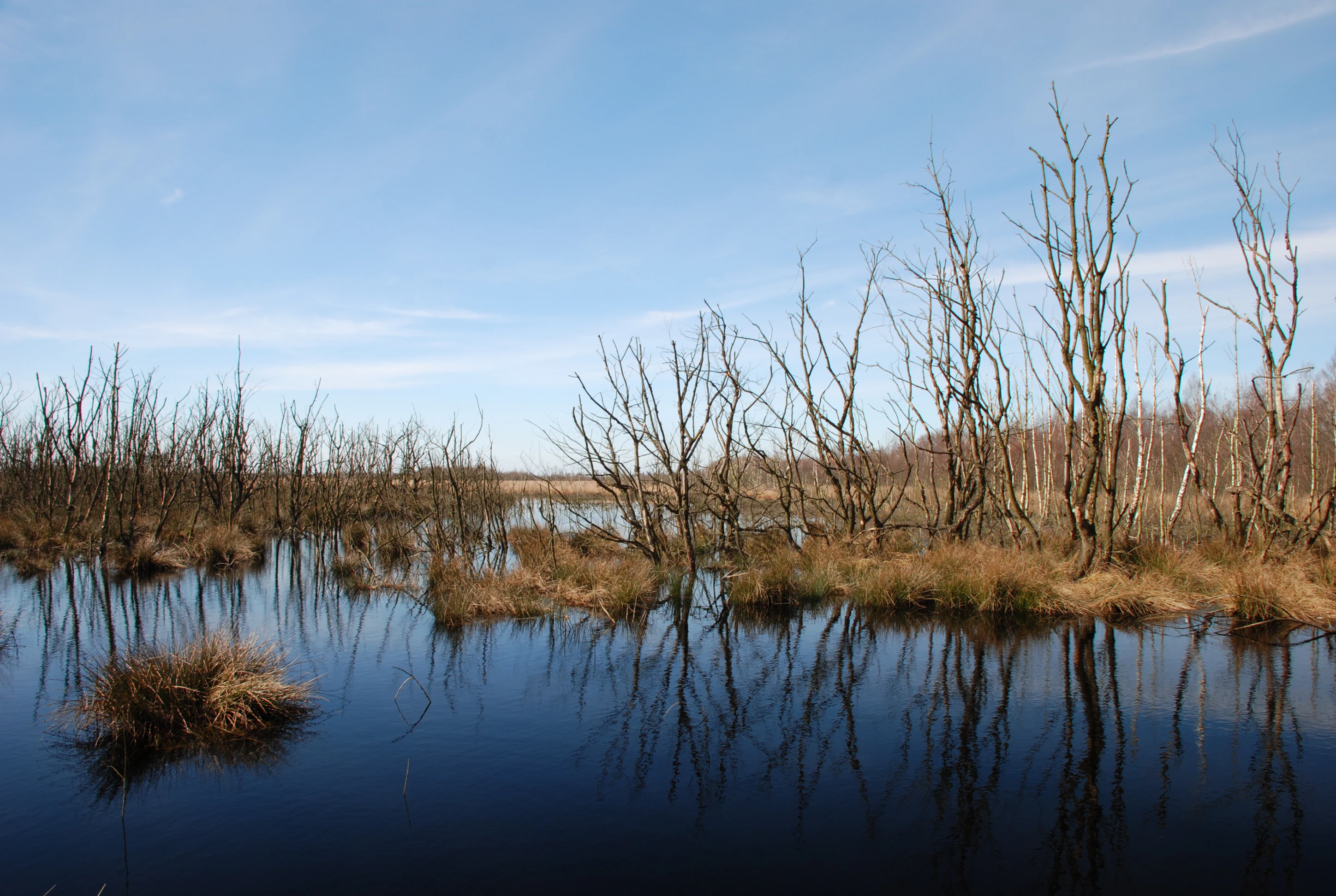
A wide landscape view of a flooded peat bog in winter, with bare trees reflecting in dark standing water under a clear blue sky.
A view of the Wesuweer Moor during winter, showing rewetting efforts with standing dead trees and water-filled peatland.

Wesuweer Moor history and protected-area timeline

Wesuweer Moor was formally placed under nature protection on 14 June 2008 under the designation 'Naturschutzgebiet Wesuweer Moor', with the identifier NSG WE 267. The designation came at a time when the area was still being actively exploited for peat on an industrial scale, and the protection order was intended to bring that practice to a close. Following the end of extraction, the reserve's strategy shifted to rewetting and long-term restoration, aligning it with broader European efforts to revive degraded raised bogs.

The reserve sits within the framework of the International Nature Park Bourtanger Moor-Bargerveen, a cross-border conservation initiative that links Lower Saxony and the Netherlands. Its establishment reflected growing regional recognition that fragmented, drained peat bogs needed active protection and restoration to recover their ecological functions, especially their role in carbon storage and water regulation.

Wesuweer Moor landscape and geographic character

The landscape of Wesuweer Moor is typical of the Emsland's northwestern lowland bogs: flat, slightly elevated above the surrounding plains, and shaped almost entirely by peat formation and water movement. Elevations in the reserve lie only between roughly 14 and 17 metres above sea level, and the terrain is dominated by open, often sparsely vegetated bog surfaces.

Drainage features are a defining element of the landscape. The area is crossed by ditches that direct water toward the Wesuwer Schloot, a stream that discharges southeast of the village of Wesuwe into the Ems river. The southern part of the reserve is also linked hydrologically to the Süd-Nord-Kanal, a major canal in the region. Where peat cutting has left its mark, the bog surface may show signs of industrial alteration, but the broader setting still reads as a wide, open moorland defined by sky, peat soils, and water-retaining vegetation.

Wesuweer Moor ecosystems, habitats, and plant life

Ecologically, Wesuweer Moor represents a raised bog (Hochmoor) system. Raised bogs in this part of Germany are nutrient-poor, rain-fed peatlands that support a specialised set of plant communities adapted to acidic, waterlogged conditions. Even within an exploited landscape, the reserve retains important examples of these habitats.

The site carries a mosaic of vegetation types: open bog surfaces, sections of moor heath (Moorheide) shaped by heather and related bog species, bog-influenced woodland, and fringes of moor grassland (Moorgrünland) that reflect centuries of grazing and mowing on peripheral peatland. The mix supports a range of bog-specialist invertebrates, plants, and birdlife and gives the reserve both ecological complexity and restoration potential once hydrological conditions are improved.

Wesuweer Moor conservation status and protection priorities

Conservation in Wesuweer Moor is centred on protecting and restoring a heavily modified raised bog. Industrial peat cutting had drained and fragmented the site, so the key challenge is to re-establish a higher water table through rewetting once extraction ceases. By stopping peat harvesting and beginning to block or manage drainage ditches, the reserve aims to allow peat-forming vegetation to return and to rebuild the bog's capacity to store carbon and regulate water.

The reserve also contributes to the wider ecological coherence of the Bourtanger Moor, one of the largest contiguous peatland complexes in northwestern Europe. Through its location within the International Nature Park Bourtanger Moor-Bargerveen, Wesuweer Moor forms part of a coordinated, cross-border effort to protect and restore bog ecosystems, complementing neighbouring protected areas such as the Versener Heidesee and the Südliches Versener Moor.

Top sights and standout views in Wesuweer Moor

Wesuweer Moor combines a large protected raised bog area, active peatland restoration, and a location within one of northwestern Europe's most important cross-border peatland conservation initiatives. Its mosaic of bog woodland, moor heath, and moor grassland gives it a layered ecological character that stands out even in a region known for extensive moors.

Monthly climate preview

Long-term representative point measurements tracking monthly temperature and precipitation rhythm

Wesuweer Moor Climate Normals and Annual Weather by Month

Wesuweer Moor exhibits a measured annual climate rhythm spanning from subzero winter minima to warm summer maximums alongside consistent monthly precipitation. Reviewing the complete twelve-month normals provides detailed context for long-term meteorological patterns across this protected location.
Annual mean10 °C
2 °C18 °C
Jan
Feb
Mar
Apr
May13°
Jun16°
Jul18°
Aug18°
Sep14°
Oct10°
Nov
Dec
Warmest month
July

18.1 °C

Coolest month
January

1.7 °C

Wettest month
December

2.5 mm/day

Driest month
April

1.4 mm/day

Park location guide

Geography guide, regional context, and park location map for Wesuweer Moor

Wesuweer Moor park geography, regions, and map view in Germany

Understand where Wesuweer Moor sits in Germany through a broader geographic reading of the surrounding landscape, nearby location context, and its mapped position within the national park landscape.

How Wesuweer Moor fits into Germany

Germany is a federal republic in Western and Central Europe with a population of over 83 million across sixteen constituent states. It is Europe's largest economy by nominal GDP and a major global exporter and importer. The capital is Berlin, and the country borders Denmark, Poland, Czech Republic, Austria, Switzerland, France, Luxembourg, Belgium, and the Netherlands.

Wider geography shaping Wesuweer Moor in Germany

Germany is located in Western and Central Europe, spanning 357,022 km². It borders Denmark to the north, Poland and the Czech Republic to the east, Austria and Switzerland to the south, and France, Luxembourg, Belgium, and the Netherlands to the west. The country has coastlines on the Baltic Sea and North Sea to the north, with the Alps located in the southern region.

Map view of Wesuweer Moor

Use this park location map to pinpoint Wesuweer Moor in Germany, understand its exact geographic position, and read its mapped placement within the surrounding landscape more clearly.

Pigeon | © OpenStreetMap contributors

Location context for Wesuweer Moor

Lower Saxony

Visualizing the raised bog terrain, moor heath, and peatland habitats of northwestern Germany

Wesuweer Moor Photos and Protected Landscape Scenery

Examine detailed visual documentation of Wesuweer Moor to understand its flat lowland terrain, open peatland surfaces, and recovering bog habitats. Photographic evidence reveals the environmental character of the protected area, displaying the distinct vegetation mosaics and drainage features that define the Emsland landscape.

A wide landscape view of a flooded peat bog in winter, with bare trees reflecting in dark standing water under a clear blue sky.

Park atlas

Compare surrounding lowland bogs, moorland reserves, and connected conservation landscapes.

Parks Near Wesuweer Moor and Related Protected Areas in the Region

Browsing parks near Wesuweer Moor reveals a continuous network of restored peatlands and protected moor habitats across the Emsland district. Comparing these adjacent reserves provides essential geographic context for understanding lowland bog ecosystems and regional conservation efforts.
Nature reserveEmsland
About 1.6 km away#1 closest

South

Südliches Versener Moor Nature Reserve: Emsland Peatland Geography and Protected Landscape

A restored raised bog within the International Nature Park Bourtanger Moor-Bargerveen

Located in Emsland, Südliches Versener Moor is a protected nature reserve defined by its history of peat extraction and ongoing rewetting efforts. The area is part of the larger Bourtanger Moor complex, featuring rare remnants of intact raised bog terrain alongside restored peatland zones that highlight regional conservation dynamics in northwestern Germany.

Area
1 km²
Established
1999
IUCN
IV
Nature reserveEmsland
About 1.7 km away#2 closest

East

Versener Heidesee Nature Reserve: Mapped Protected Areas in Emsland, Lower Saxony

Heathland habitats and aquatic ecosystems in the Bourtanger Moor region

Versener Heidesee represents a significant example of post-industrial landscape reclamation, where a motorway extraction site was transformed into a protected nature reserve. The site spans 40 hectares, featuring a 16-hectare lake and managed heathland that sustains rare algae species and diverse avian populations. Its location within the International Nature Park Bourtanger Moor-Bargerveen highlights the importance of small-scale, managed terrain for regional ecological health.

Area
0.4 km²
Established
2008
Relief
Lowland
Climate
Temperate
Nature reserveLower Saxony
About 11 km away#3 closest

North

Tausendschrittmoor Nature Reserve: Peatland Recovery and Raised Bog Geography in Emsland

A study in protected lowland peatland landscapes and recovery trajectories

Tausendschrittmoor serves as a vital nature reserve in Lower Saxony, protecting a rare pocket of raised bog habitat amidst an agricultural landscape. The reserve features two contrasting habitats: a rewetted western bog and an eastern bog woodland, each illustrating unique patterns of peatland regeneration on the North German Plain.

Area
0.655 km²
Established
1988
Nature reserveLower Saxony
About 21 km away#4 closest

East

Südtannenmoor Nature Reserve in Lower Saxony: An Atlas of Protected Bog Wetlands

Mapping rare heath pool ecosystems in the Emsland region

This nature reserve protects a fragile intersection of raised-bog remnants and shallow heath pools framed by coniferous forests. The site serves as a key reference for the restoration of specialized wetland vegetation in northwestern Germany, offering a clear view of how small-scale geography influences biodiversity in the Emsland landscape.

Area
0.049 km²
Established
2009
IUCN
IV
Relief
Lowland
Nature reserveLandkreis Emsland
About 26 km away#5 closest

Northeast

Stillgewässer bei Kluse Nature Reserve: Geographic Overview and Protected Wetland Landscape

Mapping the distinctive aquatic corridors of Landkreis Emsland.

Stillgewässer bei Kluse features a compact yet diverse mosaic of standing water pools, floating bog fringes, and oak woodlands on sandy soils. As a protected nature reserve, it functions as a crucial ecological refuge within the Emsland agricultural landscape, offering a unique opportunity to study man-made wetlands that have evolved into mature natural habitats.

Area
0.521 km²
Established
2018
Relief
Lowland
Climate
Temperate
Nature reserveEmsland
About 31 km away#6 closest

East

Zitterteiche Nature Reserve in Emsland: Mapped Protected Landscapes and Geography

A study of lowland heath ponds and environmental history

Zitterteiche represents a specific, small-scale nature reserve in the Emsland of Germany, consisting of two shallow heath ponds defined by their surrounding agricultural plains. This detailed entry maps the physical terrain and ecological shift of these protected waters, offering a focused perspective on the regional geography and the historical trajectory of this unique, formally protected wetland area.

Area
0.029 km²
Established
1937
IUCN
IV
Relief
Lowland
National parkDrenthe
About 32 km away#7 closest

Northwest

Drentsche Aa National Park: Preserved Cultural Landscape & River Valley Geography

Explore Drenthe's unique protected lands and mapped terrain.

Drentsche Aa National Park stands as a testament to a landscape preserved from the mid-19th century, offering a rare glimpse into traditional Dutch rural life. Situated in the province of Drenthe, this protected area features one of the last relatively untouched river systems in the Netherlands, characterized by meandering brooks, ancient hedgerows, and distinctive esdorp villages. The park's geography is influenced by the Saalien ice age Hondsrug ridge, creating a unique terrain of heathlands, sand dunes, and rolling landscapes ideal for atlas-based discovery.

Area
100 km²
Established
2002
IUCN
II
Relief
Lowland
Nature reserveLower Saxony
About 33 km away#8 closest

Northeast

Windelberg Nature Reserve: Protected Inland Dune and Heathland Mosaic in Lower Saxony

Historic sandy heath and oak woodland conservation site

Windelberg is a significant nature reserve in the Emsland region, featuring inland dunes and juniper heathland on the Hümmling glacial ridge. This area showcases a compact mosaic of dry, acidic habitats and relict oak woodland that reflects centuries of traditional land management in northwest Germany. Its status as a protected area within the Natura 2000 network highlights its importance for regional habitat conservation.

Area
0.163 km²
Established
2009
IUCN
IV

Common questions about visiting, size, designation, and location context for Wesuweer Moor

Wesuweer Moor FAQs for park facts, access, geography, and protected area context

Find quick answers about Wesuweer Moor, including protected-area facts, park geography, trail and visitor context, and how the park fits into its surrounding country and regional landscape.
MoriAtlas Explorer

Continue Your Protected Areas Search Across the Global Atlas

Deepen your exploration by continuing the structured search for national parks and protected areas worldwide. Utilize the comprehensive filtering capabilities to compare different conservation landscapes and refine your understanding of global park geography. Discover more about the distribution and characteristics of protected natural areas.

Global natural geography