
Mori Atlas logo
Protected landscapeWhite Mountain National Forest

Tracing the mapped boundaries, alpine ridges, and expansive river valleys of this federal wilderness area

White Mountain National Forest: A Comprehensive Atlas of New Hampshire Protected Mountain Landscapes

White Mountain National Forest encompasses 750,000 acres of rugged mountainous terrain across New Hampshire and western Maine. This protected landscape is defined by the Presidential Range, Franconia Notch, and extensive backcountry wilderness areas. Through this atlas view, examine the spatial distribution of its river valleys, alpine summits, and the dense trail networks that characterize this historic federal forest.

national forestAppalachian mountainsalpine scenerywilderness areashiking trailsAppalachian Trail
A digital illustration depicting a mountainous landscape with evergreen trees in the foreground, rolling green ridges, and a soft sunset sky.

White Mountain National Forest

Protected landscape

Park overview

Structured park overview, official facts, and landscape profile for White Mountain National Forest

White Mountain National Forest park facts, protected area profile, and essential visitor context

Review the core facts for White Mountain National Forest, including designation, size, terrain, visitor scale, habitats, and operating context in one park-focused overview.

About White Mountain National Forest

The White Mountain National Forest occupies the rugged heart of the White Mountains, a region long associated with some of the most challenging and celebrated mountain landscapes in the eastern United States. Most of the forest lies in New Hampshire, primarily across Grafton, Coos, and Carroll counties, while a smaller portion extends into Oxford County in western Maine. This combined geography gives the forest a sweeping range of high ridges, river valleys, notches, and alpine zones, much of it shaped by glacial activity and centuries of forest succession.

The forest is divided into three discontinuous sections separated by Interstate 93 and U.S. Route 2. The eastern and largest section holds the Presidential Range and many of the best-known sub-ranges, including Franconia, Twin, Bond, Sandwich, Willey, and Carter-Moriah. The western section includes Cannon Mountain, Kinsman Mountain, and Mount Moosilauke, while the northernmost section covers the Pilot Range and Mount Cabot. Threaded through all of these areas are highways such as the Kancamagus Highway, U.S. Route 3, U.S. Route 302, New Hampshire Route 16, and Sawyer Highway, which serve as both travel corridors and scenic drives.

Despite its size and protected status, the White Mountain National Forest is a working landscape managed under multiple-use principles. Timber harvesting, prescribed fire, wildlife management, watershed protection, and recreation all coexist under U.S. Forest Service administration. This dual role sets it apart from many of the more strictly protected national parks in the United States and shapes much of the public conversation about how eastern forests should be managed.

Recreation is one of the forest's defining functions. With more than 1,200 miles of hiking trails, 23 campgrounds, several visitor centers, and access to numerous ski areas, the White Mountain National Forest ranks among the most visited outdoor recreation landscapes in the eastern United States. Its strong association with Mount Washington, the Appalachian Trail, and New England hiking culture has helped make it a touchstone of outdoor identity in the Northeast.

Quick facts and research context for White Mountain National Forest

The White Mountain National Forest covers approximately 750,000 acres across New Hampshire and a small portion of Maine, making it the most eastern national forest in the United States and the only national forest in either state. It was officially established on May 16, 1918, following the Weeks Act of 1911 and initial federal land acquisitions beginning in 1914. The forest is managed by the U.S. Forest Service through a Forest Supervisor's office in Campton, New Hampshire, and three ranger districts based in Campton, Gorham, and Conway.

Its terrain includes most of the major peaks over 4,000 feet in New Hampshire, among them the Presidential Range, Franconia Range, Twin Range, and Sandwich Range. Six designated federal wilderness areas fall within or partially within the forest, providing stricter protections than the surrounding managed landscape. More than 100 miles of the Appalachian Trail traverse the forest, and along with numerous campgrounds, scenic byways, and ski areas, the forest supports a wide range of outdoor recreation.

Protection and recognition

Documented terrestrial protection scope and official conservation designations

White Mountain National Forest Protection Status and International Recognition

White Mountain National Forest maintains a documented terrestrial protection scope within its designated boundaries. Regional records outline the established conservation framework and management classifications associated with the protected landscape.

Protection details

Protection scope
Terrestrial
Transboundary protection
No
Park context

Deeper park guide and search-rich context for White Mountain National Forest

White Mountain National Forest history, landscape, wildlife, and travel context

Explore White Mountain National Forest through its history, landscape character, ecosystems, wildlife, conservation priorities, cultural context, and seasonal travel timing in a structured park guide built for atlas discovery and search intent.

Why White Mountain National Forest stands out

The White Mountain National Forest is best known for its dramatic alpine landscapes across the White Mountains of New Hampshire. The Presidential Range, anchored by Mount Washington, is one of the most famous mountain ridges in the eastern United States, and the nearby Franconia Notch draws visitors with its cliffs, notches, and historic sites. The Pemigewasset, Sandwich Range, and Wild River wilderness areas add expansive backcountry character to the forest, making it a flagship destination for both casual recreation and serious wilderness hiking. The forest is also widely recognized as a major outdoor recreation hub on the East Coast. It combines high-mountain scenery with a dense trail network, campgrounds, scenic highways like the Kancamagus, and active ski areas. Its proximity to Boston and other Northeastern cities has shaped its identity as a regional escape for hiking, climbing, leaf-peeping, and winter sports, while its 100-plus miles of Appalachian Trail contribute to its standing as a core piece of America's long-distance hiking tradition.
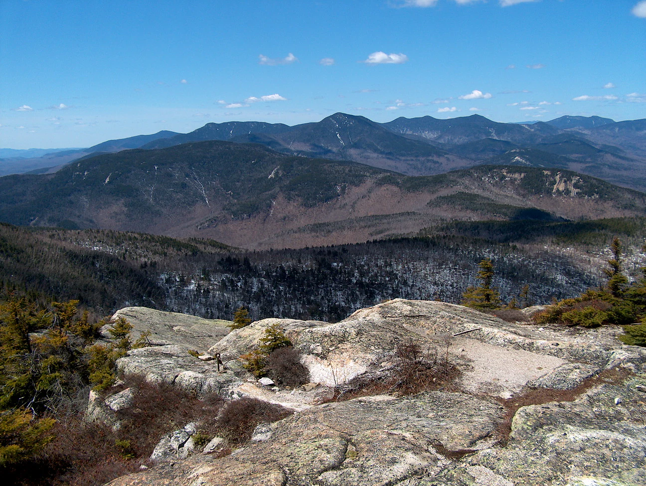
A high-angle, wide-angle shot looking out over the layered, deep-blue peaks of the Sandwich Range in New Hampshire, with a rocky, lichen-covered foreground and a clear blue sky above.
A panoramic view of the Sandwich Range within the White Mountain National Forest, characterized by expansive mountain peaks and forested slopes.

White Mountain National Forest history and protected-area timeline

The origins of the White Mountain National Forest lie in the early twentieth-century movement to reverse the environmental damage caused by unregulated logging in New England. By the late 1800s and early 1900s, the White Mountains had been heavily logged, and fires, erosion, and degraded watersheds prompted a national response.

The Weeks Act, passed by Congress in 1911, gave the federal government the authority to purchase private land to protect watersheds, navigable streams, and timber resources. Federal acquisition in the White Mountains began in 1914, and on May 16, 1918, the White Mountain National Forest was officially established as one of the earliest national forests in the East created under this authority. Conservationist and community activist Katherine Sleeper Walden played a notable role in identifying and securing threatened lands for inclusion in the forest, including significant acreage around the bowl near Wonalancet, New Hampshire.

Over the following decades, the forest's boundaries expanded and its management mandate deepened. The Federal Wilderness Protection Act of 1984 led to the formal designation of several wilderness areas within the forest, including the Presidential Range-Dry River, Great Gulf, Pemigewasset, and Sandwich Range wildernesses. The New England Wilderness Protection Act of 2006 further expanded the Sandwich Range Wilderness and created the Wild River Wilderness, strengthening the forest's standing as both a working landscape and a refuge for backcountry solitude.

White Mountain National Forest landscape and geographic character

The landscape of the White Mountain National Forest is dominated by the folded ridges, deep river valleys, and alpine summits of the White Mountains. Most of the major New Hampshire peaks above 4,000 feet fall within or adjacent to the forest, creating a skyline of exposed rock, krummholz, and subarctic vegetation at higher elevations. Glaciation shaped the region's characteristic U-shaped notches, hanging valleys, and broad cirques, the most famous of which is Franconia Notch, a narrow pass framed by cliffs and traversed by I-93.

The Presidential Range is the most prominent feature of the forest, a jagged spine that includes Mount Washington, Mount Adams, Mount Jefferson, and surrounding peaks. East of the Presidential Range the terrain diversifies into the broad Franconia Range, the more rounded Twin and Bond ranges, and the remote Sandwich Range to the south. Across the forest, the Pemigewasset Wilderness offers an expansive, heavily wooded backcountry defined by tributaries of the Pemigewasset River, while the Wild River Wilderness in the east provides a steeper, more isolated riverscape along the Wild River corridor.

Forest roads and scenic byways wind through these landscapes, and the Kancamagus Highway is one of the most celebrated scenic drives in New England, threading 34 miles through the heart of the forest along the Swift River between Lincoln and Conway. River systems shaped by water flowing off the high peaks, including the Pemigewasset, Androscoggin, Saco, and Wild River, give the forest much of its hydrological character and feed into broader New England watershed systems.

White Mountain National Forest ecosystems, habitats, and plant life

The White Mountain National Forest contains a mosaic of northern hardwood, spruce-fir, and boreal-alpine forest communities that reflect both its elevation range and its northern New England climate. At lower elevations, sugar maple, American beech, yellow birch, and white ash form classic northern hardwood stands, transitioning into mixed conifer-hardwood forests as elevation increases. Higher elevations are dominated by red spruce and balsam fir, with patches of paper birch and mountain ash, giving way to stunted krummholz and alpine tundra above the tree line.

The forest's ecosystems also include river and wetland systems that sustain fisheries and aquatic life. Cold, oxygen-rich streams descending from high peaks support native brook trout and other freshwater species, while beaver activity creates wetlands that shape both wildlife habitat and downstream flow patterns. The wilderness areas, in particular, preserve older forest stands, peatlands, and other disturbed-minimal environments that contrast with the more actively managed sections of the forest.

Elevation gradients within the forest create ecological compression, allowing northern and subalpine species to occur relatively close to lower-elevation hardwood communities. This ecological layering makes the White Mountain National Forest a useful natural laboratory for studying forest response to climate change, particularly as warmer winters and shifting precipitation patterns alter the composition of high-elevation spruce-fir stands.

White Mountain National Forest wildlife and species highlights

The White Mountain National Forest supports a diverse community of mammals, birds, and other wildlife characteristic of northern New England's forests. White-tailed deer and eastern moose are among the most visible large mammals, and the forest is also home to American black bears, eastern coyotes, and bobcats. Smaller carnivores include fisher, American marten, mink, North American river otters, and both red and gray foxes. Canadian lynx have also been documented in the region, reflecting the forest's role as habitat for species associated with the broader northern boreal landscape.

Birdlife in the forest is similarly varied. Bald eagles nest in the region and can be seen along rivers and lakes, while peregrine falcons have returned to cliff habitats after historic declines. Common ravens and other boreal bird species are associated with the high elevations of the Presidential Range, while more typical forest songbirds occupy the hardwood and mixed-forest stands below.

Beavers, raccoons, and North American porcupines are among the more familiar mammals encountered in the forest, and brook trout sustain recreational fishing in cold-water streams. Because the forest spans wilderness, roadless, and managed landscapes, wildlife habitat quality varies, with wilderness and designated roadless areas providing some of the most secure habitat for species sensitive to human disturbance.

White Mountain National Forest conservation status and protection priorities

The White Mountain National Forest represents one of the success stories of early-twentieth-century conservation policy in the eastern United States. Its establishment under the Weeks Act was a direct response to deforestation, watershed degradation, and uncontrolled fires, and it demonstrated that federally managed, multi-use forests could help restore and protect damaged landscapes. Today, the forest continues to function as a major watershed protector, regulating water flow for downstream communities and contributing to regional water quality.

Six designated federal wilderness areas within or adjacent to the forest, Presidential Range-Dry River, Great Gulf, Pemigewasset, Sandwich Range, Wild River, and Caribou-Speckled Mountain, anchor the forest's conservation role. These areas are protected from logging and commercial development and are managed primarily for recreation and scientific values. Their expansion, particularly through the 2006 New England Wilderness Protection Act, reflects ongoing efforts to strengthen habitat connectivity and preservation in the region.

The forest also plays a growing role in climate-related research and management. Projected declines in winter season length are expected to alter the ski economy and recreational patterns within and around the WMNF, while warmer conditions may already be pressing on high-elevation spruce-fir forests, wildlife habitat boundaries, and aquatic systems. These pressures position the White Mountain National Forest as an important case study for adaptive forest management in a changing climate.

White Mountain National Forest cultural meaning and human context

The White Mountain National Forest sits in a region with deep cultural ties to mountain recreation, literature, and tourism. Long before its designation, the White Mountains had become a destination for nineteenth-century artists, writers, and vacationers drawn to scenery that resembled the Alps. The completion of the Mount Washington Cog Railway in 1869 and the construction of mountain hotels and inns helped embed the region in American travel culture.

The forest's management helped preserve and shape that recreational identity across the twentieth century. The Appalachian Trail, which crosses more than 100 miles of the forest, links the region to the broader long-distance hiking movement in the United States. Local communities around the forest, including Conway, Lincoln, Campton, and Gorham, developed economies tied to outdoor recreation, leaf-peeping tourism, and increasingly skiing, as ski areas proliferated within and adjacent to the national forest boundaries.

Conservationists were also central to the forest's cultural history. Figures such as Katherine Sleeper Walden played an important role in advocating for protective land acquisition at a time when much of the White Mountains was still privately owned. Today, the coexistence of small mountain communities, working forestry, and federally managed land continues to define the cultural landscape of the region.

Top sights and standout views in White Mountain National Forest

The White Mountain National Forest stands out for its unusual combination of scale, accessibility, and ecological diversity in the eastern United States. Few eastern landscapes combine rugged four-thousand-foot mountains, designated federal wilderness, and such a dense trail network within a single federally managed unit. The forest's relationship with Mount Washington, the Presidential Range, and the Appalachian Trail gives it a recognizable identity that extends far beyond New Hampshire.

At the same time, the forest's role as a working landscape distinguishes it from more strictly protected eastern parks. The integration of timber management, watershed protection, wilderness preservation, ski areas, and recreation offers a distinctive model of multi-use forest management. Add to that six formal wilderness areas, celebrated scenic drives like the Kancamagus Highway, and wildlife ranging from moose and black bears to peregrine falcons, and the White Mountain National Forest emerges as one of the most landscape-rich and experience-rich public forest lands in the East.

Best time to visit White Mountain National Forest

The White Mountain National Forest offers sharply different experiences depending on the season. Late spring through early fall is generally the most accessible period, with the highest peaks typically free of snow by mid to late summer and the full trail network open. Autumn is especially well known for fall foliage, when the northern hardwood stands of sugar maple, birch, and beech turn shades of orange, red, and gold, drawing visitors along the Kancamagus Highway and other scenic drives.

Winter transforms the forest into a destination for skiing, snowshoeing, and winter mountaineering, particularly around the Presidential Range and the many ski areas that operate within or adjacent to the forest. High summits, including Mount Washington, have notoriously severe weather; the U.S. Forest Service notes that the area has been called home to the worst weather in America, with extreme winds and rapidly changing conditions. Visitors planning a winter trip, especially one involving high-elevation terrain, should expect sub-freezing temperatures, deep snow, and short daylight hours, conditions that historically have contributed to a long record of incidents on Mount Washington and the Presidential Range.

Monthly climate preview

Long-term representative point measurements tracking annual temperature and precipitation rhythm

White Mountain National Forest Climate Normals and Monthly Temperature Records

Historical data records long-term average temperature and monthly precipitation patterns sampled at a representative coordinate within White Mountain National Forest. Detailed monthly climate profiles provide complete statistical context for tracking annual temperature swings and precipitation variation across the protected landscape.
Annual mean5 °C
-10 °C19 °C
Jan-10°
Feb-9°
Mar-3°
Apr
May11°
Jun16°
Jul19°
Aug18°
Sep14°
Oct
Nov
Dec-6°
Warmest month
July

18.7 °C

Coolest month
January

-9.5 °C

Wettest month
October

4.2 mm/day

Driest month
January

2.8 mm/day

Park location guide

Geography guide, regional context, and park location map for White Mountain National Forest

White Mountain National Forest park geography, regions, and map view in United States of America

Understand where White Mountain National Forest sits in United States of America through a broader geographic reading of the surrounding landscape, nearby location context, and its mapped position within the national park landscape.

How White Mountain National Forest fits into United States of America

The United States of America is a federal presidential republic and one of the world's largest countries by area and population. It consists of 50 states across a vast territory spanning multiple time zones, with its capital in Washington, D.C. and largest city in New York City. The nation has a diverse economy, influential political system, and significant cultural and military presence globally.

Wider geography shaping White Mountain National Forest in United States of America

The United States occupies a vast territory in North America, bordered by Canada to the north and Mexico to the south. The 48 contiguous states stretch from the Atlantic to the Pacific Ocean, while Alaska occupies the northwestern region and Hawaii is an archipelago in the Pacific. The country encompasses diverse terrain including the Rocky Mountains, Appalachian Mountains, Great Plains, and extensive river systems.

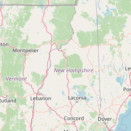
Map view of White Mountain National Forest

Use this park location map to pinpoint White Mountain National Forest in United States of America, understand its exact geographic position, and read its mapped placement within the surrounding landscape more clearly.

Pigeon | © OpenStreetMap contributors

Location context for White Mountain National Forest

MaineNew Hampshire
Recorded earthquake history

Explore the Historical Earthquake Records for White Mountain National Forest

Examine the documented history of seismic events recorded near the ridges and valleys of White Mountain National Forest. This archive offers a focused look at regional seismic activity by cataloguing historical data for research and landscape exploration.

White Mountain National Forest Earthquake History

Catalogued events

14 events

Strongest magnitude

Magnitude 4.5

Most recent event

Jan 17, 2000

This history includes earthquakes recorded inside the park or within 50 km of its borders

Visual exploration of alpine ridges, deep river valleys, and protected wilderness

White Mountain National Forest Photos and Scenic Landscapes

Visual documentation of White Mountain National Forest reveals the rugged terrain, exposed alpine ridges, and dense hardwood forests defining the region. Examining these photographs helps researchers and visitors understand the complex topography, glacial notches, and protected habitats spanning the northeastern United States.

A high-angle, wide-angle shot looking out over the layered, deep-blue peaks of the Sandwich Range in New Hampshire, with a rocky, lichen-covered foreground and a clear blue sky above.

A sweeping panoramic view of forested mountain ranges under a partly cloudy sky, with hints of autumn foliage in the valleys.

Park atlas

Compare regional protected areas and neighboring mountain terrain across New England

Parks Near White Mountain National Forest and Related Protected Landscapes

Visitors exploring White Mountain National Forest can browse nearby national forests and protected wildlands sharing similar Appalachian topography. Expanding the geographic comparison highlights connected regional ecosystems and broader conservation tracts across the northeastern United States.
Watercolor painting of a lush green landscape featuring rolling hills in the distance, a meandering stream in the midground, and wetlands with cattails in the foreground.
Protected landscapeVermont
20 km away#1 closest

West

Green Mountain National Forest: Mapped Geography and Protected Landscape Analysis

Examining the wilderness backbone of Vermont's mountainous terrain

Gain insight into the expansive boundaries of Green Mountain National Forest, an essential protected area spanning the Green Mountains of Vermont. This profile details the forest's composition, ranging from high-elevation spruce-fir zones to mixed hardwood slopes and extensive federal wilderness corridors, providing a foundational geographic understanding of this vital northeastern landscape.

Area
1,615.31 km²
Established
1932
Relief
Mountain
Climate
Temperate
Protected areaAddison County
About 71 km away#2 closest

West

Joseph Battell Wilderness: Mapping Protected Ridges in the Green Mountain National Forest

A high-elevation Appalachian landscape in Addison County, Vermont.

Spanning over twelve thousand acres, the Joseph Battell Wilderness preserves a critical core of the Green Mountains. This protected area features dramatic cliff faces like Mount Horrid and a continuous sequence of summits exceeding three thousand feet. The region provides a deep look at northern hardwood habitats and the geographic influence of the Long Trail within the broader Vermont mountain landscape.

Area
49.92 km²
Established
2006
Relief
Mountain
Climate
Temperate
Protected landscapeVermont
About 80 km away#3 closest

Southwest

Robert T. Stafford White Rocks National Recreation Area: Protected Landscape and Regional Geography

Southern Vermont wilderness, quartzite formations, and Appalachian Trail corridors.

Robert T. Stafford White Rocks National Recreation Area represents a unique fusion of protected forest and rugged geological character in southern Vermont. Known for the quartzite rockslides of Chaos Canyon and its inclusion of two distinct wilderness areas, this territory offers a complex terrain profile. Spanning over 36,000 acres, it serves as a central hub for regional backcountry exploration, blending dense hardwood ecosystems with the prominent rocky outcrops that define its distinct mountainous identity.

Area
147 km²
Established
1984
Water
Major water bodies
A horizontal watercolor painting showing a wide coastal estuary with gentle hills in the background, a winding body of water in the middle ground, and soft green trees and shrubs in the foreground.
Nature reserveNew Hampshire
About 98 km away#4 closest

South

Great Bay National Estuarine Research Reserve: Protected Coastal and Estuarine Geography

Regional tidal habitat and protected watershed in New Hampshire

Great Bay National Estuarine Research Reserve protects a vital coastal landscape characterized by broad tidal basins, fringing salt marshes, and inland woodlands. Located in southeastern New Hampshire, this nature reserve serves as an essential site for studying the intersection of freshwater and saltwater ecosystems, preserving a mosaic of land and water that illustrates the complex geography of the Atlantic coast.

Area
41.42 km²
Established
1989
Relief
Lowland
Climate
Temperate
A horizontal watercolor painting depicting a winding river flowing through a lush, forested valley with rolling hills in the background.
Wildlife reserveVermont
99 km away#5 closest

Southwest

Lye Brook Wilderness: Protected High Plateau and Forest Geography in Southern Vermont

Mapped wilderness boundaries within the Green Mountain National Forest

Spanning nearly 18,000 acres, Lye Brook Wilderness offers a deep dive into southern Vermont's natural geography. The area features a high forested plateau, complex brook valleys, and elevated ridgelines that characterize this established wilderness reserve. Ideal for those studying the regional landscape and its protected ecosystem, this record provides essential context on the forest cover, glacial terrain, and the geographic significance of this Vermont backcountry unit.

Area
73.34 km²
Established
1975
IUCN
Ib
Wildlife reserveBennington County
124 km away#6 closest

Southwest

George D. Aiken Wilderness: Protected Forest Landscapes and Ridgelines in Vermont

Detailed geographic overview of a Green Mountain wilderness reserve

Spanning over 4,800 acres in Bennington County, the George D. Aiken Wilderness stands as a significant protected area within the southern Green Mountains. The terrain features narrow ridgelines, steep valleys, and a dense canopy of northern hardwoods that remain unmanaged to maintain wilderness standards. This area serves as a primary geographic anchor for Eastern wilderness preservation efforts in the United States.

Area
19 km²
Established
1984
IUCN
Ib
Relief
Mountain
National parkMaine
172 km away#7 closest

East

Acadia National Park: A Protected Landscape within Maine's Regional Geography

Discover mapped boundaries and natural terrain context.

Delve into the protected landscape of Acadia National Park, a key entity within the geography of Maine. This dedicated atlas view helps you understand the park's mapped boundaries and its role within the broader regional context. Explore the natural terrain and understand how protected areas are situated geographically, enriching your understanding of conservation landscapes.

Area
198.6 km²
Established
1919
IUCN
V
Visitors
3.9M annual
A watercolor painting of a green, rolling coastal landscape with gentle hills and trees under a white background.
Protected landscapeMassachusetts
About 173 km away#8 closest

South

Boston Harbor Islands National and State Park: Mapping Coastal Protected Landscapes

A diverse archipelago of islands and tidal harbors in Massachusetts

Boston Harbor Islands National and State Park offers an expansive look at coastal geography within the Massachusetts Bay. Spanning dozens of islands and peninsulas, this protected landscape captures a blend of drumlin terrain, tidal salt marshes, and historic maritime structures set directly against the urban skyline of Boston.

Area
6 km²
Established
1996
Visitors
28.2K annual
Relief
Lowland

Common questions about visiting, size, designation, and location context for White Mountain National Forest

White Mountain National Forest FAQs for park facts, access, geography, and protected area context

Find quick answers about White Mountain National Forest, including protected-area facts, park geography, trail and visitor context, and how the park fits into its surrounding country and regional landscape.
MoriAtlas Explorer

Continue Your Protected Areas Search Across the Global Atlas

Deepen your exploration by continuing the structured search for national parks and protected areas worldwide. Utilize the comprehensive filtering capabilities to compare different conservation landscapes and refine your understanding of global park geography. Discover more about the distribution and characteristics of protected natural areas.

Global natural geography