


Mori Atlas logo
Protected areaWiązogóra

A comprehensive look at the twelve distinct bog and mire vegetation complexes within this significant Natura 2000 landscape

Wiązogóra Protected Area and the Wetland Ecosystems of the West Pomeranian Voivodeship in Northern Poland

(Obszar mający znaczenie dla Wspólnoty PLH320066 Wiązogóra)

Wiązogóra represents a vital ecological enclave on the Białogardzka Plain, preserving a concentrated mosaic of transitional mires, dystrophic lakes, and boreal-style swamp forests. Formally recognized under the EU Habitats Directive, this protected area spans roughly 490 hectares, serving as an essential refuge for rare wetland communities and acidic forest types that are increasingly scarce in the broader lowland terrain of northwestern Poland.

Natura 2000bogs and mirestransitional miresraised bogsbog forestsdystrophic lakes
A flat vector-style illustration of a canyon with a winding river and a waterfall in the distance, surrounded by evergreen trees under a soft sun.

Wiązogóra

Protected area

Park overview

Structured park overview, official facts, and landscape profile for Wiązogóra

Wiązogóra park facts, protected area profile, and essential visitor context

Review the core facts for Wiązogóra, including designation, size, terrain, visitor scale, habitats, and operating context in one park-focused overview.

About Wiązogóra

Wiązogóra is a protected ecological site in northwestern Poland that forms part of the European Natura 2000 network. It was confirmed as a Site of Community importance in January 2011 through an update of the continental biogeographic list, meaning that Poland committed to its conservation under the EU Habitats Directive. The site carries the reference code PLH320066 and covers approximately 489.50 hectares on the Białogardzka Plain, a flat lowland region within the West Pomeranian Voivodeship.

Physically the area consists of twelve distinct complexes of bog vegetation, embedded in the broader landscape of the Równina Białogardzka mesoregion. This part of Pomerania is characterized by glacial landforms, sandy lowlands, lakes, and extensive forests. Wiązogóra's protection focuses on the wetland elements of that landscape, particularly the dystrophic lakes and ponds, the transitional mires and quaking bogs, and the raised bogs that still show capacity for natural or stimulated regeneration. Such mire systems have become increasingly fragmented across central Europe, giving the site particular biogeographical significance.

The ecological profile of Wiązogóra extends well beyond open mires. It also encompasses boggy woodlands dominated by birch, pine, and spruce, representing the Vaccinio uliginosi-Betuletum pubescentis, Vaccinio uliginosi-Pinetum, Pino mugo-Sphagnetum, and Sphagno girgensohnii-Piceetum community types. These boreal-style swamp forests are complemented by patches of acidophilous beech forest of the Luzulo-Fagenion alliance and acidophilous oak forest of the Quercion robori-petraeae alliance, creating a mosaic of wet and dry acidic habitats close to one another. The combination of so many habitat types from the directive's annex in a relatively small lowland area is what makes Wiązogóra noteworthy from a conservation standpoint.

Administratively the site spans parts of Świeszyno and Manowo municipalities. Because it is a Natura 2000 site rather than a national park or landscape park, its focus is strictly on habitat protection rather than tourism or visitor interpretation. Nevertheless, it represents an important node in the network of protected Polish lowland mires and swamp forests, contributing to the broader preservation of continental bog habitats across northern Europe.

Quick facts and research context for Wiązogóra

Wiązogóra is a Natura 2000 Site of Community importance with the reference code PLH320066. It was formally adopted by a European Commission decision in January 2011, confirming it as part of the fourth updated list of continental biogeographic region sites under the Habitats Directive. The site is situated within the West Pomeranian Voivodeship of Poland and lies within Świeszyno and Manowo communes. Its total area is approximately 489.50 hectares, and it covers twelve separate bog vegetation complexes of the Białogardzka Plain. Habitats listed under the directive include dystrophic lakes and ponds, transitional mires, degraded but regenerable raised bogs, acidophilous beech forests, acidophilous oak forests, bog woodlands, and birch and pine boreal bog forests.

Protection and recognition

Terrestrial protected area classification, management scope, and Natura 2000 records

Wiązogóra Protection Status and Documented International Recognition Data

Wiązogóra holds documented terrestrial protection status supported by official Natura 2000 recognition records. Visitors can examine the designated management scope, boundary parameters, and verified international conservation sources.

International recognition

Protection details

Protection scope
Terrestrial
Transboundary protection
No
Park context

Deeper park guide and search-rich context for Wiązogóra

Wiązogóra history, landscape, wildlife, and travel context

Explore Wiązogóra through its history, landscape character, ecosystems, wildlife, conservation priorities, cultural context, and seasonal travel timing in a structured park guide built for atlas discovery and search intent.

Why Wiązogóra stands out

Wiązogóra is recognized above all for its exceptional concentration of bog and mire habitats on the Białogardzka Plain. Its twelve separate bog vegetation complexes include dystrophic water bodies, transitional mires with Scheuchzerio-Caricetea vegetation, raised bogs in a degraded but regenerable state, and extensive bog forests classified as boreal birch and pine swamp woodlands. Equally important is the blend of acidic forest types it protects, ranging from acidophilous beechwoods of the Luzulo-Fagenion alliance to acidophilous oak forests of the Quercion robori-petraeae alliance. This combination of mire, bog forest, and dry acidic forest communities in a single small lowland area gives the site its particular ecological character and its value within the continental Natura 2000 network.
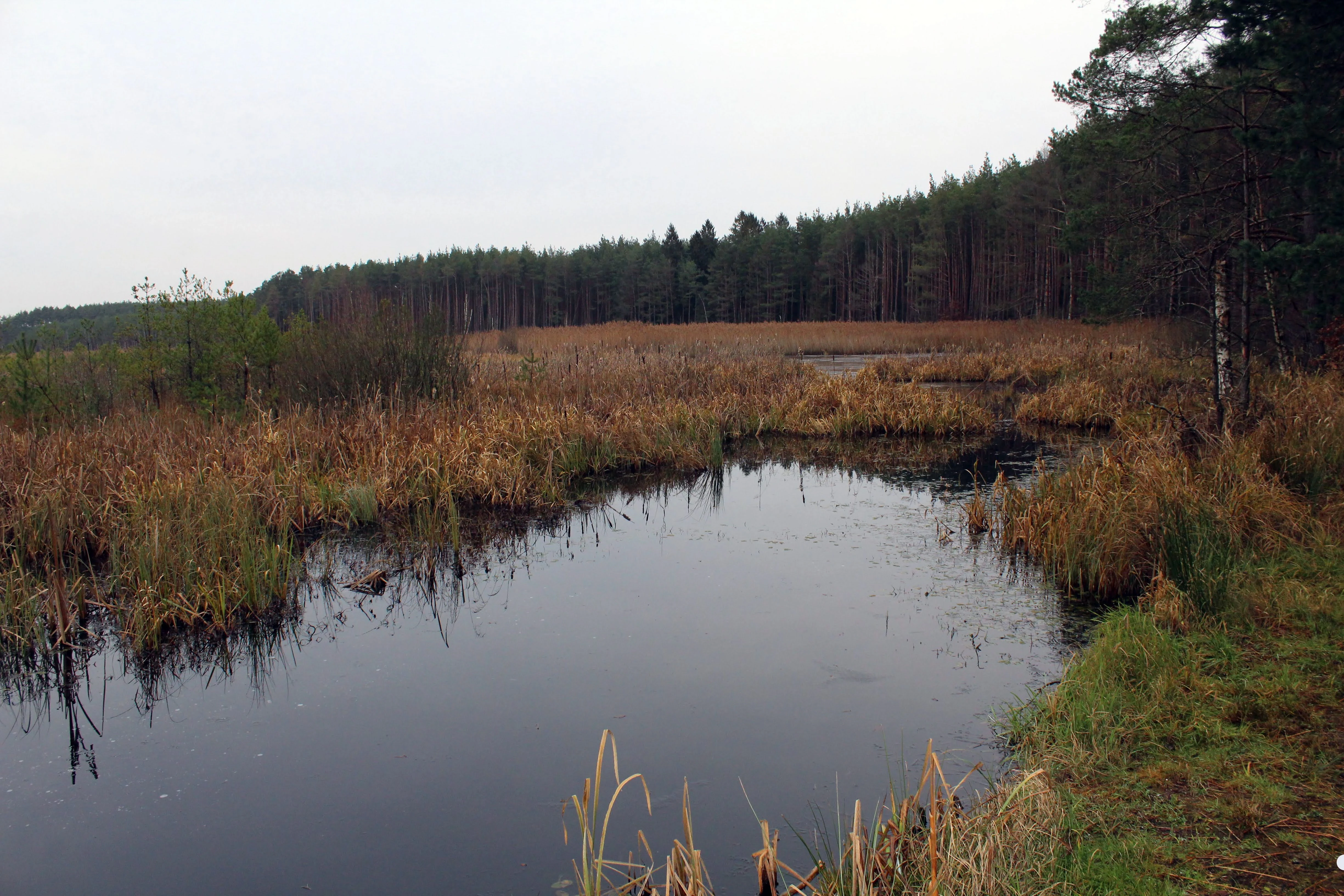
A calm, dark-water lake surrounded by grasses, reeds, and a pine forest under an overcast sky.
A view of Czarne Lake within the Wiązogóra area, featuring surrounding marshy vegetation and forest.

Wiązogóra history and protected-area timeline

Wiązogóra was formally recognized as a Site of Community importance in January 2011, through a decision by the European Commission adopting a fourth updated list of sites in the continental biogeographic region under Directive 92/43/EEC, the EU Habitats Directive. The decision confirmed the site, bearing the reference code PLH320066, as part of the Natura 2000 ecological network and committed Poland to its long-term conservation.

The site's designation reflects the broader development of European habitat protection policy from the 1990s onward, in which member states have progressively identified and listed areas containing habitats and species referenced in the Habitats Directive. For Wiązogóra, inclusion in this list was the culmination of national-level habitat surveys aimed at locating representative examples of bog, mire, and acidic forest communities on the Białogardzka Plain. Its ongoing protection continues to be tied to the maintenance and, where possible, restoration of the degraded raised bog complexes within its boundaries.

Wiązogóra landscape and geographic character

The landscape of Wiązogóra is shaped by the flat, lowland character of the Równina Białogardzka, a mesoregion in the West Pomeranian Voivodeship typical of the post-glacial geography of northern Poland. Elevations across the site are modest, and the terrain is dominated by gentle glacial landforms, sandy outwash plains, and shallow depressions in which mires and bog forests have developed over time.

Rather than dramatic relief, the site offers a mosaic of small-scale features: dystrophic ponds and lakes occupying bog hollows, raised bog domes in varying states of conservation, transitional mires with quaking surfaces, and zones of swamp forest where the ground is soft and waterlogged for much of the year. The separation of the area into twelve distinct bog vegetation complexes means that visitors moving through the wider landscape would perceive Wiązogóra as a network of wet, forested, and open patches embedded in the surrounding woodland.

The surrounding region continues into the broader Pomeranian lowlands, marked by coniferous and mixed forests, agricultural land, and scattered lakes of glacial origin. Against that background, the boggy and acidic terrain of Wiązogóra stands apart as a distinct ecological enclave.

Wiązogóra ecosystems, habitats, and plant life

Ecologically, Wiązogóra is defined by the unusual proximity of multiple mire and forest habitat types on a relatively compact surface. The site protects dystrophic lakes and ponds, which are nutrient-poor, acidic, and often dark-stained waters characteristic of peatland systems. Together with these open water features, the site contains transitional mires and trembling bogs dominated by vegetation of the Scheuchzerio-Caricetea class, as well as raised bogs that, although degraded, retain the capacity for natural recovery or stimulated restoration.

A significant portion of the site is covered by boggy woodlands, including boreal-style birch and pine swamp forests assigned to communities such as Vaccinio uliginosi-Betuletum pubescentis, Vaccinio uliginosi-Pinetum, and Pino mugo-Sphagnetum, alongside spruce-dominated Sphagno girgensohnii-Piceetum forests. These wet, acidic woodlands form a transitional belt between the open mires and the surrounding dry forest landscape.

Dry acidic forest communities also occur on better-drained portions of the area. Acidophilous beech forests of the Luzulo-Fagenion alliance and acidophilous oak forests of the Quercion robori-petraeae alliance represent the upland forest character of the plain. The alternating pattern of bog forest, open mire, dystrophic water body, and dry acid forest gives Wiązogóra a layered ecological structure that is both ecologically valuable and useful for scientific study of lowland bog succession.

Wiązogóra wildlife and species highlights

Wiązogóra's wildlife character is shaped primarily by its mosaic of bog, mire, and acidic forest habitats. Dystrophic lakes and ponds, transitional mires, and bog forests typically support characteristic assemblages of wetland-dependent species, including invertebrates, amphibians, and birdlife associated with open water, reedbeds, and boggy woodland edges in the Pomeranian lowlands.

The boreal-style bog forests of birch, pine, and spruce provide habitat for forest species adapted to acidic, wet conditions, while the surrounding acidophilous beech and oak stands offer additional forest habitat for typical lowland forest fauna. The combination of open mire, stagnant water, and structurally varied forest means that the site can host a range of breeding and resting species typical of Polish lowland peatlands, although the site's primary recognition under Natura 2000 rests on its habitats rather than on individual species listings.

Wiązogóra conservation status and protection priorities

Wiązogóra's conservation significance lies in its role as a representative example of lowland bog and mire habitats within the European Natura 2000 network. The site's designation under the Habitats Directive acknowledges that its dystrophic lakes, transitional mires, regenerable raised bogs, and bog forests represent habitat types listed in the directive's annexes, and that the Polish lowlands still contain functioning, if sometimes degraded, examples of these communities.

A particular conservation focus is the restoration potential of the degraded raised bog complexes, which are explicitly listed as still capable of natural or assisted regeneration. The presence of bog forests, acidic beech and oak forests, and mire vegetation in twelve distinct complexes within a single small site increases its biogeographical value, since habitat fragmentation elsewhere in central Europe has reduced the occurrence of such tightly clustered peatland-forest mosaics.

As a Site of Community importance, Wiązogóra is subject to the conservation obligations that come with Natura 2000 membership, including the requirement that Poland maintain or restore the favorable conservation status of the listed habitats. Its long-term value depends on keeping hydrological conditions intact, limiting peatland disturbance, and preventing the conversion or drainage of these bog complexes.

Top sights and standout views in Wiązogóra

Wiązogóra stands out for the way it concentrates a remarkable diversity of bog and mire habitats within a small lowland area on the Białogardzka Plain. Twelve separate bog vegetation complexes, ranging from dystrophic ponds and transitional mires to raised bogs and boreal-style swamp forests, give the site a layered structure that is increasingly rare in the intensively used lowlands of northwestern Poland.

The presence of acidic beech and oak forests alongside the mire and bog forest communities adds a complementary dry-habitat dimension, producing a compact ecological mosaic within a single Natura 2000 boundary. Its 2011 recognition under the EU Habitats Directive confirms its role as a formally protected piece of the European peatland and acidic-forest heritage.


Monthly climate preview

Long term representative point records tracking monthly precipitation and temperature variation

Wiązogóra Climate Normals and Annual Temperature Rhythm

Representative coordinates document sustained annual temperature swings alongside consistent monthly precipitation patterns measured across a thirty year climatology baseline. Detailed twelve month statistical profiles provide deeper context for comparing monthly climate normals across the protected area.
Annual mean8 °C
-2 °C18 °C
Jan-2°
Feb-1°
Mar
Apr
May12°
Jun16°
Jul18°
Aug18°
Sep14°
Oct
Nov
Dec
Warmest month
July

18.3 °C

Coolest month
January

-1.6 °C

Wettest month
July

2.9 mm/day

Driest month
April

1.3 mm/day

Park location guide

Geography guide, regional context, and park location map for Wiązogóra

Wiązogóra park geography, regions, and map view in Poland

Understand where Wiązogóra sits in Poland through a broader geographic reading of the surrounding landscape, nearby location context, and its mapped position within the national park landscape.

How Wiązogóra fits into Poland

Poland, officially the Republic of Poland, is a Central European country spanning from the Baltic Sea in the north to the Carpathian Mountains in the south. It borders Germany, Czech Republic, Slovakia, Ukraine, Belarus, Lithuania, and Kaliningrad Oblast. The country has a temperate climate, diverse landscapes, and is known for its rich history, cultural heritage, and strong economic position within the EU.

Wider geography shaping Wiązogóra in Poland

Poland occupies 312,696 km2 in Central Europe, extending from the Baltic Sea coast in the north to the Sudetes and Carpathian Mountains in the south. It borders Germany to the west, Czech Republic and Slovakia to the south, Ukraine and Belarus to the east, and Lithuania and Kaliningrad Oblast to the northeast. The landscape includes lowland plains, uplands, and mountain ranges.

Map view of Wiązogóra

Use this park location map to pinpoint Wiązogóra in Poland, understand its exact geographic position, and read its mapped placement within the surrounding landscape more clearly.

Pigeon | © OpenStreetMap contributors

Location context for Wiązogóra

West Pomeranian Voivodeship

Explore detailed imagery of mires, bog forests, and glacial terrain across the protected reserve.

Wiązogóra Photos and Protected Area Scenery: Visualizing the Lowland Bog Landscape

Visual documentation captures the complex mosaic of transitional mires, dystrophic lakes, and swamp woodlands that define the lowland terrain. Examining these protected area photographs reveals the ecological character and distinct habitat structure of the regional enclave.

A calm, dark-water lake surrounded by grasses, reeds, and a pine forest under an overcast sky.

A straight asphalt road stretching into the distance, flanked on both sides by dense coniferous and deciduous trees under an overcast sky.

Park atlas

Compare regional wetland habitats and surrounding lowland protected landscapes

Explore Protected Areas and Parks Near Wiązogóra in the Pomeranian Lowlands

Browse other protected areas and regional reserves located across the surrounding Pomeranian lowlands. Continuing beyond Wiązogóra reveals a broader geographic network of wetland habitats and glacial terrain.
Nature reserveWest Pomeranian Voivodeship
About 5.6 km away#1 closest

East

Mechowisko Manowo Nature Reserve: Protected Fen and Wetland Landscapes in West Pomerania

Geographic atlas of rare peatland and spring mire habitats

Mechowisko Manowo Nature Reserve protects a distinct assemblage of alkaline fens, sedge dominated turzycowiska, and swamp forests in the post glacial landscape of northern Poland. This reserve provides a rare look at the basin-like peatland terrain and calcareous groundwater systems that characterize the Dzierżęcinka river valley within the West Pomeranian region.

Area
0.555 km²
Established
2018
Scope
Terrestrial
Water
Major water bodies
Nature reserveZachodniopomorskie
About 13 km away#2 closest

South

Dolina Rzeki Leśnicy Nature Reserve: Mapped Protected Landscapes in Zachodniopomorskie

A glacial valley reserve featuring riverine forest habitats.

Dolina Rzeki Leśnicy Nature Reserve preserves a distinct young glacial river valley characterized by its tightly meandering stream, amphitheater-like springheads, and diverse gallery forests. Located on the Białogard Plain, this protected landscape demonstrates the intersection of humid riparian ecosystems and undulating glacial relief, providing an essential study of Polish lowland geography and forest conservation.

Area
0.593 km²
Established
2024
Relief
Upland
Climate
Temperate
Nature reserveZachodniopomorskie
About 19 km away#3 closest

East

Dolina Zgniłej Strugi Nature Reserve: Geographic Overview of Protected Mires and River Valleys

A diverse wetland corridor in the West Pomeranian region.

Dolina Zgniłej Strugi Nature Reserve protects a mosaic of spring-mire, peatland, and riparian forest habitats along the Zgniła Struga river. This landscape offers a rare example of naturally occurring lowland river dynamics and diverse mire communities within the Wysoczyzna Polanowska, anchoring an important ecological network in north-western Poland.

Area
1.523 km²
Established
2024
Relief
Lowland
Climate
Temperate
Nature reserveZachodniopomorskie
About 20 km away#4 closest

Northeast

Rezerwat przyrody Jodły Karnieszewickie: Mapped Geography and Protected Forest Landscapes

A rare botanical refuge for mature silver fir stands in Zachodniopomorskie.

Rezerwat przyrody Jodły Karnieszewickie is a specialized nature reserve in northern Poland that serves as a living laboratory for forest conservation. The site maintains a dense, closed canopy of silver fir trees that deviate from the region's typical woodland patterns, fostering a microclimate suitable for rare epiphytes. This protected area offers deep insight into postglacial lowland forest composition and the survival of relict plant populations.

Area
0.368 km²
Established
1978
Relief
Lowland
Climate
Temperate
Nature reserveZachodniopomorskie
25 km away#5 closest

West

Trzebiatowsko-Kołobrzeski Pas Nadmorski: Protected Coastal Habitat and Regional Geography

Nature reserve covering Baltic dunes, wetlands, and estuaries.

Spanning across the Szczecin Coastal Plain, this extensive nature reserve protects vital coastal habitats, including rare dune sequences, brackish lagoons, and bog forests. The area serves as a critical geographic corridor for migratory bird species and diverse sand-loving plant communities in the Zachodniopomorskie region of Poland.

Area
174.69 km²
Established
2008
Relief
Lowland
Climate
Temperate
Nature reserveZachodniopomorskie
About 32 km away#6 closest

East

Rezerwat przyrody Dolina Pustynki: Geography and Protected River Valley Landscapes in Zachodniopomorskie

Mapped riverine corridors and ancient deciduous forest ecosystems

Explore the detailed ecological landscape of Rezerwat przyrody Dolina Pustynki in the West Pomeranian region. This nature reserve serves as an essential example of submontane river habitats and well-preserved oak-hornbeam forests within the Polanów High Plain, maintaining vital connections between regional water catchments and protected woodlands.

Area
0.392 km²
Established
2024
Relief
Upland
Climate
Temperate
Nature reserveWest Pomeranian Voivodeship
About 35 km away#7 closest

Southeast

Jezioro Szare Nature Reserve: Regional Geography and Protected Freshwater Landscape Analysis

Analyzing the forest-fringed lobelia lake basin in West Pomeranian Voivodeship

Situated in the West Pomeranian Voivodeship, Jezioro Szare Nature Reserve protects a distinct lobelia-type lake ecosystem. The reserve is characterized by its steep, forested basin rim and clear, low-nutrient water, functioning as a significant reference site for rare freshwater habitats within the Pomeranian lake district landscape.

Area
0.087 km²
Established
1974
Relief
Upland
Scope
Terrestrial
Protected areaWest Pomeranian Voivodeship
40 km away#8 closest

West

Wybrzeże Trzebiatowskie Protected Area: Coastal Wetlands and Baltic Shoreline Map

A diverse wetland corridor in the West Pomeranian Voivodeship.

Wybrzeże Trzebiatowskie represents a significant stretch of the Baltic coastline, characterized by a narrow and elongated geographic profile. The protected landscape highlights a complex interplay of lagoon lakes, river floodplains, and classic dune systems, providing critical habitat within the broader West Pomeranian regional geography.

Area
317.576 km²
Established
2007
Relief
Lowland
Scope
Mixed

Common questions about visiting, size, designation, and location context for Wiązogóra

Wiązogóra FAQs for park facts, access, geography, and protected area context

Find quick answers about Wiązogóra, including protected-area facts, park geography, trail and visitor context, and how the park fits into its surrounding country and regional landscape.
MoriAtlas Explorer

Continue Your Protected Areas Search Across the Global Atlas

Deepen your exploration by continuing the structured search for national parks and protected areas worldwide. Utilize the comprehensive filtering capabilities to compare different conservation landscapes and refine your understanding of global park geography. Discover more about the distribution and characteristics of protected natural areas.

Global natural geography