

Mori Atlas logo
Nature reserveWiesen- und Weidenflächen an der Oste

Mapping the natural grassland mosaic and riverine wetlands of the Oste floodplain district.

Wiesen- und Weidenflächen an der Oste: A Protected Floodplain Landscape in Landkreis Stade

(Naturschutzgebiet Wiesen- und Weidenflächen an der Oste)

Wiesen- und Weidenflächen an der Oste represents a key nature reserve situated within the Oste river lowlands of Lower Saxony. This protected area spans a mosaic of intensively managed grasslands and reed beds that undergo regular seasonal flooding. The landscape serves as a critical habitat for migratory and breeding birds within the broader geographical context of the Elbe estuary region in Landkreis Stade.

lowland grasslandwet grasslandreed bedfloodplainOste rivernature reserve
A stylized flat illustration of a river winding through green and yellow agricultural meadows, bordered by low cliffs and hills under a sunny sky.

Wiesen- und Weidenflächen an der Oste

Nature reserve

Park overview

Structured park overview, official facts, and landscape profile for Wiesen- und Weidenflächen an der Oste

Wiesen- und Weidenflächen an der Oste park facts, protected area profile, and essential visitor context

Review the core facts for Wiesen- und Weidenflächen an der Oste, including designation, size, terrain, visitor scale, habitats, and operating context in one park-focused overview.

About Wiesen- und Weidenflächen an der Oste

Wiesen- und Weidenflächen an der Oste is a compact but ecologically meaningful nature reserve in the northern German lowlands. It is situated within the Oste river lowlands, an agricultural floodplain landscape in the Landkreis Stade district of Lower Saxony, and protects about 121 hectares of grassland on the right bank of the Oste between the villages of Kranenburg and Brobergen. The reserve was formally designated on 2 April 1985 and has been registered both under German nature conservation law as NSG LÜ 109 and in the World Database on Protected Areas under WDPA-ID 166300.

Despite its modest size, the protected area plays an outsized role in the regional conservation of grassland and wetland birdlife. Its value lies in the combination of actively managed meadows and pastures with scattered reed beds, set within a flood-prone stretch of the Oste valley. This mosaic of open grassland, taller reed vegetation, and seasonal standing water offers nesting, foraging, and resting habitat across multiple seasons.

The reserve is managed by Niedersächsischer Landesbetrieb für Wasserwirtschaft, Küsten- und Naturschutz (NLWKN), the regional state agency responsible for water management, coastal defense, and nature conservation in Lower Saxony. Under international classification systems, the area falls within IUCN Category IV, denoting a Habitat/Species Management Area, which reflects its role in active conservation of specific species and habitat types rather than strict wilderness preservation.

Quick facts and research context for Wiesen- und Weidenflächen an der Oste

Wiesen- und Weidenflächen an der Oste is a designated nature reserve (Naturschutzgebiet) in the Landkreis Stade district of Lower Saxony, northern Germany, classified under the German federal nature conservation framework and at the international level as an IUCN Category IV Habitat/Species Management Area. Officially established on 2 April 1985, it covers an area of about 121 hectares and carries the official designation NSG LÜ 109, with a corresponding entry in the World Database on Protected Areas (WDPA-ID 166300).

The reserve lies in the Oste river floodplain at elevations between roughly 0 and 2 meters above sea level, on the right bank of the Oste, west of Kranenburg and Brobergen. It consists of managed grassland (Wiesen und Weiden) interspersed with reed beds and is managed by NLWKN, the regional agency responsible for water management, coastal protection, and nature conservation in Lower Saxony.

Protection and recognition

Examine documented protected area records, management details, and official recognition metrics.

Wiesen- und Weidenflächen an der Oste Protection Status and Records

Wiesen- und Weidenflächen an der Oste gathers formal protection status, designation history, and verified database records. Structured conservation metrics provide transparent access to official administrative data for this protected area.

Protection details

WDPA ID
166300
Park context

Deeper park guide and search-rich context for Wiesen- und Weidenflächen an der Oste

Wiesen- und Weidenflächen an der Oste history, landscape, wildlife, and travel context

Explore Wiesen- und Weidenflächen an der Oste through its history, landscape character, ecosystems, wildlife, conservation priorities, cultural context, and seasonal travel timing in a structured park guide built for atlas discovery and search intent.

Why Wiesen- und Weidenflächen an der Oste stands out

The reserve is best known as a protected grassland and reed-bed mosaic in the Oste floodplain, where seasonally flooded meadows and scattered stands of reed provide critical habitat for rare breeding birds such as Montagu's harrier (Wiesenweihe), marsh harrier (Rohrweihe), and short-eared owl (Sumpfohreule), along with a wide range of wintering migratory waterbirds and wetland species. It is also recognized for showing how a small, intensively managed lowland grassland area can simultaneously support agricultural use and high-value bird conservation, owing to the regular winter and spring flooding dynamics of the Oste river that shape its character.
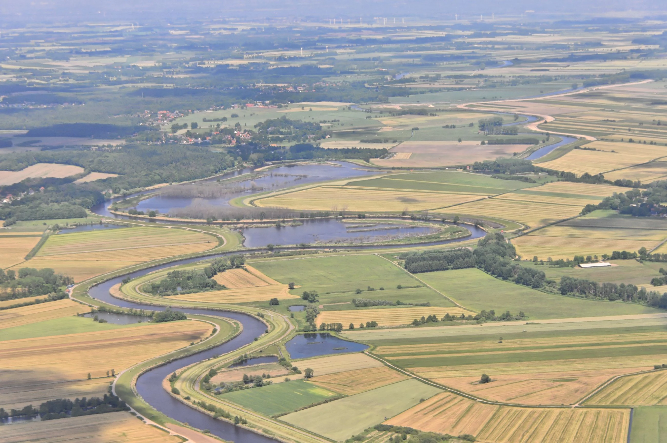
An aerial view of a winding river flowing through a mosaic of agricultural fields and wetland areas, characterized by green and golden patches of vegetation.
Aerial view of the Oste river meandering through the wetland meadows of the Wiesen- und Weidenflächen an der Oste nature reserve.

Wiesen- und Weidenflächen an der Oste history and protected-area timeline

The protected area was officially established on 2 April 1985, when the right-bank grassland along the Oste river, west of Kranenburg and Brobergen, was designated as the Naturschutzgebiet Wiesen- und Weidenflächen an der Oste. The impetus for protection was the area's known importance for several rare and declining bird species associated with wet grassland and reed habitats.

Even after designation, the grassland has continued to be intensively managed, reflecting the long-standing agricultural character of the Oste lowlands. Since its establishment, the reserve has been administered by the Niedersächsischer Landesbetrieb für Wasserwirtschaft, Küsten- und Naturschutz (NLWKN), which coordinates water management, coastal protection, and nature conservation across Lower Saxony.

Wiesen- und Weidenflächen an der Oste landscape and geographic character

The reserve occupies a very low-lying stretch of the Oste floodplain, with elevations ranging only from about 0 to 2 meters above sea level. It sits on the right bank of the Oste river, a tidal-influenced lowland watercourse that flows through the broader Elbe estuary region of northern Lower Saxony. The flat terrain is shaped less by dramatic relief than by the interplay between the river's flood dynamics and centuries of agricultural land use.

The visible landscape within the reserve is dominated by open grassland (Wiesen und Weiden), punctuated by scattered, irregular patches of reed bed that stand taller than the surrounding meadows. These reed patches (Röhricht) form a distinctive texture across the otherwise uniform lowland plain. Because the area sits within the Oste's natural flood corridor, periodic flooding reshapes surface conditions and water levels, contributing to the dynamic wetland character that gives the site its conservation value.

Wiesen- und Weidenflächen an der Oste ecosystems, habitats, and plant life

Ecologically, the reserve protects a lowland wet grassland mosaic bordered and interspersed with reed beds, all embedded within a larger agricultural floodplain. This combination of short grass swards and taller emergent vegetation creates a structurally diverse habitat relative to typical arable lowlands elsewhere in northern Germany.

The wetland grass- and sedge-dominated vegetation, together with the reed patches, supports a network of feeding, nesting, and refuge sites for birdlife that requires both open grassland and emergent vegetation in close proximity. Although the area is small and the surrounding matrix is heavily agricultural, the protected grassland functions as a critical local refuge for habitat types that have become increasingly rare across the intensively farmed German lowlands.

Wiesen- und Weidenflächen an der Oste wildlife and species highlights

The reserve's wildlife significance is overwhelmingly focused on birds, particularly those tied to wet grassland and reed habitats. Species explicitly associated with the area in conservation records include Montagu's harrier (Wiesenweihe), marsh harrier (Rohrweihe), and short-eared owl (Sumpfohreule), all of which rely on a mix of open hunting grounds and reed-rich nesting or roosting sites.

In addition to these breeding species, the grasslands and reed beds serve as a winter resting and foraging area for a broad spectrum of migratory waterbirds and wetland species. The combination of seasonal flooding, scattered reeds, and open meadow means the site offers usable habitat for birds in different life stages, from breeding pairs in summer to overwintering flocks under colder conditions.

Wiesen- und Weidenflächen an der Oste conservation status and protection priorities

The conservation importance of the reserve lies in safeguarding a small but high-quality remnant of wet grassland and reed habitat within an otherwise heavily cultivated Oste floodplain. The reasons for its designation are explicitly avifaunistic: the presence of rare breeding raptors such as Montagu's harrier and marsh harrier, and of short-eared owl, together with the area's function as a wintering site for migratory species, gave the direct justification for protection in 1985.

In international terms, the site is classified as an IUCN Category IV Habitat/Species Management Area, reflecting an active-management approach rather than strict preservation. At the national level, it is part of the German Naturschutzgebiete network under the designation NSG LÜ 109 and is tracked in the World Database on Protected Areas under WDPA-ID 166300. The reserve thus sits within both the German statutory protection system and the global protected-area inventory, underscoring its recognized value beyond purely regional planning frameworks.

Top sights and standout views in Wiesen- und Weidenflächen an der Oste

The reserve's defining qualities are its mosaic of intensively managed lowland grassland and scattered reed beds, its position within the regularly flooded Oste floodplain, and its disproportionate importance for rare breeding birds such as Montagu's harrier, marsh harrier, and short-eared owl, alongside numerous wintering migratory species.

Equally notable is the way the site demonstrates that active agricultural use and strong conservation outcomes can coexist in a single small floodplain area, provided the hydrology and habitat structure are maintained through protection and management by NLWKN.

Best time to visit Wiesen- und Weidenflächen an der Oste

The reserve's appeal shifts with the seasons in ways that reflect its avian focus. Late spring and summer are the most relevant period for observing breeding birds tied to the wet meadows and reed beds, including harriers and short-eared owl, when conditions are at their driest and bird activity is concentrated around nesting and foraging territories.

Winter and early spring bring a different character: regular flooding from the Oste reshapes the surface, and the area functions as a refuge for migratory waterbirds and other wintering species, offering the best opportunities to observe flocking and wetland birdlife. Visitors interested in waterbird viewing are likely to find the cooler months more rewarding, while those drawn to breeding raptor observation will find the warmer season more productive.


Monthly climate preview

Long-term monthly temperature and precipitation averages for Landkreis Stade

Wiesen- und Weidenflächen an der Oste Climate Normals and Annual Temperature Range

Recorded baseline measurements from 1991 to 2020 show the measured monthly temperature and precipitation rhythm across a representative coordinate in Wiesen- und Weidenflächen an der Oste. Examining the full twelve-month profile provides complete historical averages for detailed climate comparison.
Annual mean9 °C
1 °C18 °C
Jan
Feb
Mar
Apr
May13°
Jun16°
Jul18°
Aug18°
Sep14°
Oct10°
Nov
Dec
Warmest month
July

17.9 °C

Coolest month
January

0.8 °C

Wettest month
July

2.6 mm/day

Driest month
April

1.4 mm/day

Park location guide

Geography guide, regional context, and park location map for Wiesen- und Weidenflächen an der Oste

Wiesen- und Weidenflächen an der Oste park geography, regions, and map view in Germany

Understand where Wiesen- und Weidenflächen an der Oste sits in Germany through a broader geographic reading of the surrounding landscape, nearby location context, and its mapped position within the national park landscape.

How Wiesen- und Weidenflächen an der Oste fits into Germany

Germany is a federal republic in Western and Central Europe with a population of over 83 million across sixteen constituent states. It is Europe's largest economy by nominal GDP and a major global exporter and importer. The capital is Berlin, and the country borders Denmark, Poland, Czech Republic, Austria, Switzerland, France, Luxembourg, Belgium, and the Netherlands.

Wider geography shaping Wiesen- und Weidenflächen an der Oste in Germany

Germany is located in Western and Central Europe, spanning 357,022 km². It borders Denmark to the north, Poland and the Czech Republic to the east, Austria and Switzerland to the south, and France, Luxembourg, Belgium, and the Netherlands to the west. The country has coastlines on the Baltic Sea and North Sea to the north, with the Alps located in the southern region.

Map view of Wiesen- und Weidenflächen an der Oste

Use this park location map to pinpoint Wiesen- und Weidenflächen an der Oste in Germany, understand its exact geographic position, and read its mapped placement within the surrounding landscape more clearly.

Pigeon | © OpenStreetMap contributors

Location context for Wiesen- und Weidenflächen an der Oste

Landkreis Stade

Visual exploration of floodplain meadows, reed beds, and wetland habitats

Wiesen- und Weidenflächen an der Oste Photos and Landscape Scenery

Visual records capture the low-lying terrain, seasonal flood dynamics, and open grassland mosaic of Wiesen- und Weidenflächen an der Oste. Examining photographic views helps visitors understand the protected wetland environment and habitat structure supporting rare regional bird species.

An aerial view of a winding river flowing through a mosaic of agricultural fields and wetland areas, characterized by green and golden patches of vegetation.

Park atlas

Compare regional lowland landscapes and connected wetland reserves in northern Germany

Explore Other Protected Areas Near Wiesen- und Weidenflächen an der Oste

Browse nearby protected landscapes and related river valley reserves extending outward from Wiesen- und Weidenflächen an der Oste. Evaluating adjacent lowland habitats provides deeper context for regional floodplains and wetland conservation networks.
Nature reserveLower Saxony
About 8.8 km away#1 closest

Northwest

Westerberg und oberes Hackemühlener Bachtal: Protected Forest and River Valley Geography

Nature reserve geography in the district of Cuxhaven

Westerberg und oberes Hackemühlener Bachtal protects a unique interface between Saalian end moraine forests and the headwaters of the Hackemühlener Bach. The landscape showcases a transition from conifer and oak woodlands down to species-rich wet grasslands and stream-side shrubbery. This geographic profile makes the reserve a significant area for studying glacial landforms and riparian corridors within the broader context of the Cuxhaven district in Lower Saxony.

Area
2.18 km²
Established
2012
IUCN
IV
Relief
Upland
Nature reserveLandkreis Cuxhaven
About 17 km away#2 closest

Northwest

Wildes Moor bei Stinstedt: Protected Raised Bog and Wetland Geography in Lower Saxony

Examining Moorland Habitat and Terrain within Landkreis Cuxhaven

Wildes Moor bei Stinstedt serves as a crucial example of a small scale raised bog landscape surviving within a modified agricultural plain. This overview outlines the protected area's history of peat extraction and drainage, offering a detailed perspective on the site's ongoing role as a managed habitat for specialized bog vegetation in the North German coastal region.

Area
0.57 km²
Established
1984
IUCN
IV
Relief
Lowland
Nature reserveLower Saxony
About 18 km away#3 closest

West

Windbrackenholz Nature Reserve: A Detailed Look at Lower Saxony Woodland Geography

Protected oak-beech habitat in the Cuxhaven district.

Windbrackenholz represents a key example of long-standing forest conservation in the Lower Saxony lowlands. This nature reserve provides a critical window into the structure of Geest woodland habitats, characterized by its mature oak and beech trees and its integration into the wider regional forest mosaic. Delve into the protected boundaries and landscape context of this significant northwestern German site.

Area
0.34 km²
Established
1985
IUCN
IV
Nature reserveLower Saxony
About 27 km away#4 closest

Southwest

Wollingster See und Randmoore: A Detailed Map and Geography of This Lower Saxony Nature Reserve

Examining the intersection of glacial lake basins and bog restoration efforts

Wollingster See und Randmoore protects a critical intersection of aquatic and terrestrial ecosystems within Lower Saxony. Learn about the reserve's formation as a potential pingo or glacial pothole, its distinct water quality, and the ongoing efforts to restore its surrounding raised-bog and moor-heath landscape through traditional grazing and rewetting.

Area
1.17 km²
Established
1932
IUCN
IV
Relief
Lowland
Nature reserveLandkreis Stade
About 30 km away#5 closest

Southeast

Steinbeckforst Nature Reserve: Geography and Protected Area Context in Landkreis Stade

Ancient beech forests and lowland brook valley landscapes.

Steinbeckforst serves as a critical nature reserve in Lower Saxony, characterized by century-old beech stands and sandy ground moraine topography. This geographic profile examines how the forest and Steinbeck brook valley function as a protected habitat corridor within the wider district of Stade.

Area
0.7 km²
Established
2018
IUCN
IV
Watercolor illustration of a landscape with green hills, a body of water, and grassy foregrounds
National parkSchleswig-Holstein
About 34 km away#6 closest

North

Schleswig-Holstein Wadden Sea National Park: Germany's Largest Protected Tidal Landscape

Explore the mapped geography of this vital North Sea national park.

Schleswig-Holstein Wadden Sea National Park is a monumental protected area, recognized globally as a UNESCO World Heritage Site for its extraordinary tidal wetland ecosystem. This page offers detailed insights into its geographic scope, from the North Frisian Islands to the Elbe estuary, highlighting the dynamic interplay of mudflats, salt marshes, and coastal terrain. Discover the park's critical role as a migratory bird flyway and marine nursery, providing rich data for geographic and atlas exploration of this unique North Sea protected landscape.

Area
4,410 km²
Established
1985
IUCN
II
Visitors
1.7M annual
Nature reserveLower Saxony
About 35 km away#7 closest

Northwest

Wanhödener Moor Nature Reserve: Mapping Bog Ecology in Lower Saxony, Germany

Protected raised bog and coastal wetland landscapes

Located in the district of Cuxhaven, Wanhödener Moor represents a crucial fragment of original raised bog terrain in the North German Plain. This protected nature reserve provides insight into the historic human impact on peatlands and current conservation efforts to maintain wetland ecology and bog woodland transitions across the North Sea coastal region.

Area
0.39 km²
Established
1986
IUCN
IV
Relief
Lowland
Nature reserveLower Saxony
About 37 km away#8 closest

South

Swatte Flag Nature Reserve in Lower Saxony: Protected Landscape and Geographic Overview

An important refuge for heathland and bog-margin habitats.

Swatte Flag is a protected nature reserve in Lower Saxony, known for its two shallow Schlatt ponds and surrounding heathland mosaic. Established to manage rare habitat types within a reclaimed moorland landscape, the reserve features a sharp ecological contrast between its nutrient-poor grassland, wet bog pockets, and the adjacent intensive farmland.

Area
0.164 km²
Established
1965
IUCN
IV
Relief
Lowland

Common questions about visiting, size, designation, and location context for Wiesen- und Weidenflächen an der Oste

Wiesen- und Weidenflächen an der Oste FAQs for park facts, access, geography, and protected area context

Find quick answers about Wiesen- und Weidenflächen an der Oste, including protected-area facts, park geography, trail and visitor context, and how the park fits into its surrounding country and regional landscape.
MoriAtlas Explorer

Continue Your Protected Areas Search Across the Global Atlas

Deepen your exploration by continuing the structured search for national parks and protected areas worldwide. Utilize the comprehensive filtering capabilities to compare different conservation landscapes and refine your understanding of global park geography. Discover more about the distribution and characteristics of protected natural areas.

Global natural geography