
Mori Atlas logo
Nature reserveSteinbeckforst

Examining the ecological terrain, brook valley boundaries, and glacial landscape of this German nature reserve.

Steinbeckforst Nature Reserve: A Detailed Geographic Atlas of Ancient Woodland in Landkreis Stade

Steinbeckforst represents a significant protected area within the Stader Geest region of Lower Saxony. This nature reserve preserves ancient wood-rush beech forests and vital brook valley habitats along the Steinbeck stream. By examining the mapped boundaries and forest composition, users gain insight into the conservation value of this glacial terrain and its role as a corridor for diverse woodland species.

beech forestancient woodlandStader Geestbrook valleyGeestbachnature reserve
A flat-style digital illustration of a mountain canyon with a multi-tiered waterfall flowing into a river below, surrounded by pine trees under a pale sun.

Steinbeckforst

Nature reserve

Park overview

Structured park overview, official facts, and landscape profile for Steinbeckforst

Steinbeckforst park facts, protected area profile, and essential visitor context

Review the core facts for Steinbeckforst, including designation, size, terrain, visitor scale, habitats, and operating context in one park-focused overview.

About Steinbeckforst

Steinbeckforst sits in the Stader Geest, the gently undulating, sandy glacial landscape that characterises much of the northern part of the district of Stade in Lower Saxony. In contrast to the more open farmland and marshes typical of the wider region, the reserve preserves one of the few remaining blocks of genuinely old deciduous woodland in the area, anchored on the historic forest soils around the Steinbeck brook. Its elevation is modest, rising only from roughly 27 to 46 metres above sea level, yet this low-profile setting on a ground moraine supports a remarkably rich forest community.

The reserve protects the eastern part of the Steinbeck forest, together with a section of the Steinbeck valley east of it. The brook itself is a small Geestbach, a sandy-bottomed lowland stream typical of the Geest landscape. Although parts of the Steinbeck have been straightened, the channel still retains natural-looking sections that provide habitat for species such as the Eurasian otter and both river and brook lamprey. The valley adds moisture, still water, and a partly open corridor running through the surrounding woodland.

The forest is the true heart of the area. Beech woodland dominates the slopes and plateau, with wood-rush beech forest (Hainsimsen-Buchenwald) as the prevailing community, reflecting the acidic, sandy woodland soils of the Geest. Scattered patches of more base-rich woodruff beech forest (Waldmeister-Buchenwald) occur alongside it. In the valley, older oak and oak-hornbeam stands with pedunculate oaks over 120 years old give the reserve an added layer of structural age and biodiversity. A high proportion of standing and fallen deadwood runs through these woodlands, increasing their value for saproxylic insects, hole-nesting birds, and forest bats.

The reserve is embedded in a wider mosaic of habitat protection. Almost the entire area lies within the FFH (Habitat Directive) site "Auetal und Nebentäler", and Steinbeckforst forms a direct southern extension of the Aueniederung und Nebentäler reserve designated in 1997. Together, the two reserves create a continuous corridor of protected forest and brook-valley habitat. Beyond the reserve boundaries, Steinbeckforst borders the larger Auetal landscape protection area (Landschaftsschutzgebiet), is mostly surrounded by agricultural land, touches the eastern edge of the village of Ruschwedel, and lies just north of the Buxtehude to Harsefeld railway line. This combination of connected protected habitat and surrounding low-intensity land use gives the reserve real importance for landscape-scale biodiversity in the district of Stade.

Quick facts and research context for Steinbeckforst

Steinbeckforst is a nature reserve (Naturschutzgebiet) in Lower Saxony, northern Germany, with the official designation NSG LÜ 325 and a total area of approximately 70 hectares. It lies east of Harsefeld in the district of Stade, within the Stader Geest, a low-lying region of sandy glacial deposits.

The reserve forms part of the EU-protected FFH site "Auetal und Nebentäler" and connects directly to the older Aueniederung und Nebentäler nature reserve to the north, creating a combined habitat corridor along the Steinbeck brook. It has been protected since 29 June 2018 and is managed under the long-term ecological forestry programme of the Lower Saxon State Forests (Niedersächsische Landesforsten).

Protection and recognition

Documented protection records and designation details for Steinbeckforst

Steinbeckforst Protection Status and International Recognition Data

Examine the official protection status, management framework, and conservation registry records established for Steinbeckforst. Review structured data sources providing verified administrative records and international recognition tracking for protected areas.

Protection details

WDPA ID
555690903
Park context

Deeper park guide and search-rich context for Steinbeckforst

Steinbeckforst history, landscape, wildlife, and travel context

Explore Steinbeckforst through its history, landscape character, ecosystems, wildlife, conservation priorities, cultural context, and seasonal travel timing in a structured park guide built for atlas discovery and search intent.

Why Steinbeckforst stands out

Steinbeckforst is best known for its ancient, near-natural beech forests growing on the Stader Geest, including substantial areas of wood-rush beech woodland (Hainsimsen-Buchenwald) with stands well over a century old. It represents one of the more intact examples of the historic Steinbeck forest landscape in the district of Stade, retaining high amounts of deadwood that support rare woodland specialists. Equally distinctive is its role as a protected section of the Steinbeck lowland brook, a small Geestbach running through a glacial valley that adds wetland habitats, still waters, and stream-side oak woodland to the reserve's profile. Together with the adjoining Aueniederung und Nebentäler reserve, Steinbeckforst anchors a connected habitat complex for bats, amphibians, black stork, cavity-nesting birds, and the Eurasian otter within an otherwise heavily agricultural landscape.
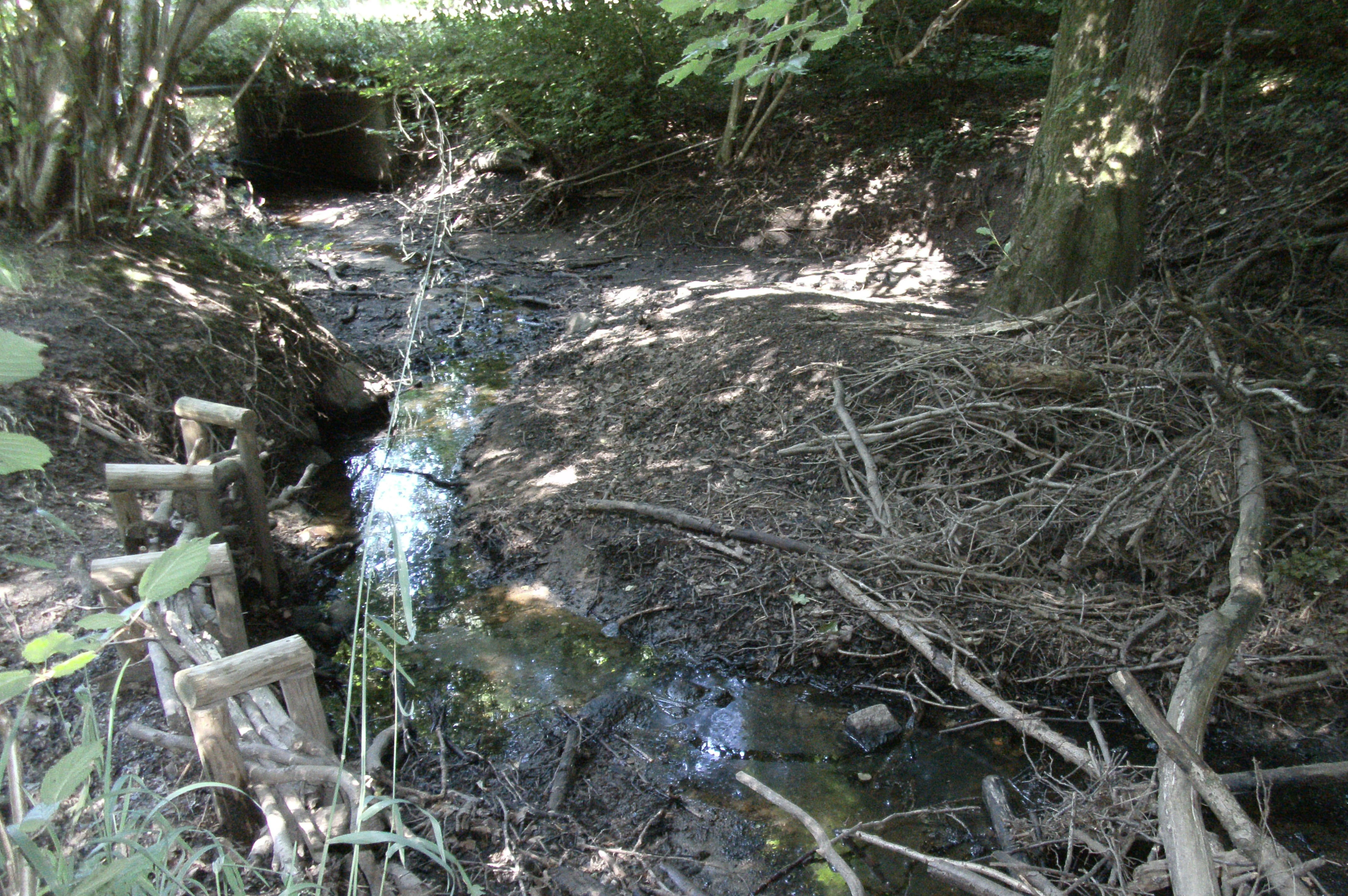
A small, narrow stream flows through a shaded woodland area with tree roots, fallen branches, and wooden bank stabilization structures visible.
The Geestbach stream winding through the wooded terrain of Steinbeckforst.

Steinbeckforst history and protected-area timeline

Until its formal designation in 2018, the area now protected as Steinbeckforst was already part of the neighbouring nature reserve Aueniederung und Nebentäler, which had been established in 1997. The separation and re-declaration as an independent reserve on 29 June 2018 reflected growing recognition of the Steinbeck forest as a distinct and especially valuable component of the broader Auetal valley system.

The designation (official code NSG LÜ 325) brought explicit legal protection to the eastern Steinbeck forest and the adjoining section of the Steinbeck brook valley. Responsibility lies with the district of Stade as the lower nature conservation authority. The forests have long been managed by the Lower Saxon State Forests under the LÖWE principles, a long-term ecological forest development framework that emphasises near-natural forestry, retention of old trees and deadwood, and partial non-use zones. The area's status within the FFH site "Auetal und Nebentäler" further ties its conservation to European habitat protection objectives for woodland, brook, and valley habitats.

Steinbeckforst landscape and geographic character

The landscape of Steinbeckforst is a compact but distinctive mix of gentle glacial terrain and lowland brook valley. The reserve occupies part of the Stader Geest, an area of sandy ground moraine shaped during the last glaciation, resulting in softly undulating ground at elevations between about 27 and 46 metres above sea level. Despite these modest heights, the topography is enough to create visibly different forest communities on the slopes, the plateau, and the valley floor.

Steinbeckforst ecosystems, habitats, and plant life

Steinbeckforst's ecological character is defined by its long-established deciduous forest communities, which reflect the older woodland history of the Steinbeck area. Acidic, sandy Geest soils support extensive stands of wood-rush beech forest, while slightly richer patches give rise to woodruff beech forest and, in the valley, oak and oak-hornbeam woodland with very old pedunculate oaks. The unusually high deadwood content of these forests creates the structural complexity needed to support a wide range of woodland specialists.

The brook valley adds a contrasting habitat layer. The Steinbeck and its adjoining damp and still-water areas create moist woodland, wetland edge, and aquatic habitats that complement the drier forest on the slopes. This combination of forest, brook, and small wetlands within a single, connected reserve is one of the key ecological strengths of Steinbeckforst, and forms part of the broader FFH site "Auetal und Nebentäler".

Steinbeckforst wildlife and species highlights

Steinbeckforst supports a diverse community of woodland, brook, and wetland species, many of them tied to the presence of old trees and deadwood. The forest is home to several bat species, including the noctule and the Nathusius' pipistrelle, both typically associated with mature deciduous woodland and tree cavities.

The moist areas along the Steinbeck are important for amphibians. The European tree frog uses the still waters and wet sections of the valley, while the northern crested newt occurs in similar habitats. The Steinbeck itself has been recorded as habitat for the Eurasian otter, as well as for river lamprey and brook lamprey, both of which depend on cleaner sections of small streams like this Geestbach. Where parts of the brook retain natural-looking structure, these species can persist alongside the reserve's broader forest fauna.

Steinbeckforst conservation status and protection priorities

Steinbeckforst's conservation significance lies in its protection of ancient forest on historically old woodland soils, a category that has become increasingly rare in the surrounding agricultural Geest landscape. Almost the entire reserve overlaps with the FFH site "Auetal und Nebentäler", giving it direct importance for European habitat conservation alongside its national-level status as a Naturschutzgebiet. The combination of high deadwood levels, multiple forest community types, and connected brook-valley habitat makes it a key node in the protected habitat network of the district of Stade.

Monthly climate preview

Monthly temperature ranges and precipitation averages recorded at Landkreis Stade

Steinbeckforst Climate Normals and Long-Term Temperature Patterns

Representative coordinates track long-term average temperature variations and daily precipitation measurements across the year. Full monthly climate profiles provide detailed records for comparing seasonal shifts and multi-year meteorological data.
Annual mean9 °C
1 °C18 °C
Jan
Feb
Mar
Apr
May13°
Jun16°
Jul18°
Aug18°
Sep14°
Oct10°
Nov
Dec
Warmest month
July

17.9 °C

Coolest month
January

0.8 °C

Wettest month
July

2.6 mm/day

Driest month
April

1.4 mm/day

Park location guide

Geography guide, regional context, and park location map for Steinbeckforst

Steinbeckforst park geography, regions, and map view in Germany

Understand where Steinbeckforst sits in Germany through a broader geographic reading of the surrounding landscape, nearby location context, and its mapped position within the national park landscape.

How Steinbeckforst fits into Germany

Germany is a federal republic in Western and Central Europe with a population of over 83 million across sixteen constituent states. It is Europe's largest economy by nominal GDP and a major global exporter and importer. The capital is Berlin, and the country borders Denmark, Poland, Czech Republic, Austria, Switzerland, France, Luxembourg, Belgium, and the Netherlands.

Wider geography shaping Steinbeckforst in Germany

Germany is located in Western and Central Europe, spanning 357,022 km². It borders Denmark to the north, Poland and the Czech Republic to the east, Austria and Switzerland to the south, and France, Luxembourg, Belgium, and the Netherlands to the west. The country has coastlines on the Baltic Sea and North Sea to the north, with the Alps located in the southern region.

Map view of Steinbeckforst

Use this park location map to pinpoint Steinbeckforst in Germany, understand its exact geographic position, and read its mapped placement within the surrounding landscape more clearly.

Pigeon | © OpenStreetMap contributors

Location context for Steinbeckforst

Landkreis StadeLower Saxony

Explore protected area scenery, glacial terrain, and mature woodland habitats across the nature reserve.

Steinbeckforst Photos and Landscapes: Visualizing Ancient Beech Forests and Brook Valleys

Visual documentation captures the undulating sandy moraines, mature beech stands, and winding lowland brook channels that define the protected landscape. Examining field photography reveals the ecological character and varied microhabitats preserved within the historic forest boundary.

A small, narrow stream flows through a shaded woodland area with tree roots, fallen branches, and wooden bank stabilization structures visible.

Park atlas

Compare adjacent forest reserves and regional glacial valley landscapes

Parks Near Steinbeckforst and Surrounding Protected Natural Areas

Browsing other protected areas near Steinbeckforst reveals connected woodland corridors and lowland brook habitats across the Stader Geest region. Comparing these neighboring reserves provides deeper context into regional beech forests and glacial terrain formations.
Nature reserveLandkreis Harburg
About 17 km away#1 closest

East

Wulmstorfer Heide mit Bornberg: Protected Nature Reserve and Glacial Landscape Map

Regional geography and habitat network in Landkreis Harburg, Lower Saxony

This protected area features a unique mosaic of dry heath, nutrient-poor grassland, and mature broadleaf woodland. Located near the Hamburg border, it provides an essential habitat refuge within the Harburger Berge, characterized by sandy glacial soils and former military training terrain that supports specialized reptiles, amphibians, and bird species.

Area
2.72 km²
Established
2024
IUCN
IV
Relief
Upland
Nature reserveLandkreis Rotenburg (Wümme)
About 23 km away#2 closest

South

Wümmeniederung mit Rodau, Wiedau und Trochelbach: Protected Wetland and Heath Landscape

Regional geography and floodplain connectivity in Landkreis Rotenburg

This nature reserve protects a sprawling lowland landscape characterized by the Wümme, Rodau, Wiedau, and Trochelbach rivers. The terrain features a mosaic of near-natural meandering streams, species-rich wet meadows, and rare raised bog remnants, providing a comprehensive overview of northern German lowland ecology.

Area
28.96 km²
Established
2020
IUCN
IV
Relief
Lowland
Nature reserveLandkreis Stade
About 30 km away#3 closest

Northwest

Wiesen- und Weidenflächen an der Oste: Nature Reserve and Floodplain Geography

Protected grassland and wetland habitat in the Oste river corridor

The Wiesen- und Weidenflächen an der Oste nature reserve in Landkreis Stade encompasses a significant floodplain area defined by the tidal dynamics of the Oste river. This protected territory supports diverse bird species through its unique combination of open meadows and reed-rich wet grasslands, illustrating the interplay between traditional agricultural land use and critical conservation management in Northern Germany.

Area
1.21 km²
Established
1985
IUCN
IV
A watercolor painting showing a panoramic view of a calm river with a small, vegetated island in the center and pink wildflowers in the foreground.
Nature reserveHamburg
About 31 km away#4 closest

East

Schweenssand Nature Reserve: Protected Elbe Floodplain Geography in Hamburg Germany

Tidal freshwater wetlands, reedbeds, and riverine forest mosaics

Spanning 35 hectares along the Süderelbe, Schweenssand acts as a vital protected area within the Hamburg city boundary. Its geography consists of freshwater tidal flats, mudflats, and ancient-looking floodplain forests that are continuously shaped by the Elbe river tide. This site offers a clear view into the ecological complexity of urban-fringe river landscapes and European Natura 2000 protected zones.

Area
0.4 km²
Established
1993
IUCN
IV
Relief
Lowland
Nature reserveLandkreis Rotenburg (Wümme)
About 35 km away#5 closest

Southwest

Westliches Borchelsmoor Nature Reserve: Geographic Profile and Protected Bog Landscape

A preserved peatland fragment in the Landkreis Rotenburg district.

Located in northern Lower Saxony, Westliches Borchelsmoor represents a significant remnant of the historical Borchelsmoor raised bog. The reserve showcases a complex topography of old drainage lines and birch woodland, providing a clear window into the ecological transition of modified moorland. This site serves as a core component of the local wetland mosaic and offers valuable insights into ongoing peatland restoration and bog conservation.

Area
1.25 km²
Established
2010
IUCN
IV
Relief
Lowland
Nature reserveLower Saxony
About 35 km away#6 closest

East

Stemmbruch Nature Reserve: Protected Lowland Bog Geography in Lower Saxony, Germany

A resilient moorland habitat near the Seeve floodplain

Stemmbruch serves as a vital nature reserve in the Harburg district, protecting a rare hanging spring bog system. This compact protected area features a mosaic of bog pools, heath, and swamp woodland, demonstrating the complex hydrologic connectivity between the sandy geest ridge and the surrounding northern German lowland plains.

Area
0.56 km²
Established
1989
IUCN
IV
Relief
Lowland
Nature reserveLower Saxony
About 36 km away#7 closest

South

Stellmoor und Weichel: Geographic Profile of a Lower Saxony Nature Reserve

Protected geest woodlands and peat-bog mosaic landscapes

Examine the territorial boundaries and ecological features of Stellmoor und Weichel. Located on the flat geest ridge of Northern Germany, this reserve maps the transition from managed deciduous woodland to complex mire, willow thicket, and bog-fringe water systems, maintaining a long-standing natural forest reserve status.

Area
2.18 km²
Established
2018
IUCN
IV
Watercolor painting showing a wide, panoramic view of a marshy landscape with green fields, winding water channels, and faint pink clouds in the sky.
Nature reservePinneberg
About 38 km away#8 closest

Northeast

Himmelmoor Nature Reserve and Mapped Peatland Landscape in Pinneberg, Germany

Detailed geography of a restored raised bog

Trace the extensive bog terrain of Himmelmoor in Pinneberg, Germany. This former raised bog is now a focal point for large-scale wetland rewetting. Explore the site's flat, waterlogged geography, industrial heritage, and its protected status as a crucial natural mosaic within the broader regional landscape.

Established
2022
Relief
Lowland
Climate
Temperate
Access
Easy access

Common questions about visiting, size, designation, and location context for Steinbeckforst

Steinbeckforst FAQs for park facts, access, geography, and protected area context

Find quick answers about Steinbeckforst, including protected-area facts, park geography, trail and visitor context, and how the park fits into its surrounding country and regional landscape.
MoriAtlas Explorer

Continue Your Protected Areas Search Across the Global Atlas

Deepen your exploration by continuing the structured search for national parks and protected areas worldwide. Utilize the comprehensive filtering capabilities to compare different conservation landscapes and refine your understanding of global park geography. Discover more about the distribution and characteristics of protected natural areas.

Global natural geography