

Mori Atlas logo
Nature reserveWiesners Swamp Nature Reserve

Examining the ecological significance of this Billabong Creek floodplain catchment and its woodland habitats.

Wiesners Swamp Nature Reserve: A Protected Ephemeral Wetland Landscape in New South Wales

Wiesners Swamp Nature Reserve stands as a preserved inland wetland within the South Western Slopes of New South Wales. Centred on a shallow depression along the Billabong Creek floodplain, this protected area features a distinct seasonal cycle where water flows through river red gum woodlands and surrounding higher ground. By maintaining these natural hydraulic patterns, the reserve serves as an important representative example of southern Riverina floodplain geography and native habitat connectivity.

wetlandephemeral swampriver red gum woodlandfloodplainbillabong creek catchmentsouth western slopes

Wiesners Swamp Nature Reserve

Nature reserve

Park overview

Structured park overview, official facts, and landscape profile for Wiesners Swamp Nature Reserve

Wiesners Swamp Nature Reserve park facts, protected area profile, and essential visitor context

Review the core facts for Wiesners Swamp Nature Reserve, including designation, size, terrain, visitor scale, habitats, and operating context in one park-focused overview.

About Wiesners Swamp Nature Reserve

Wiesners Swamp Nature Reserve sits within the gently undulating agricultural countryside of the New South Wales South Western Slopes, a transitional landscape between the higher Great Dividing Range to the east and the broader flat Riverina plains to the west. Its setting within the headwaters of Simmons Creek, which ultimately drains into Billabong Creek, places it in the wider Murray-Darling catchment that defines much of inland south-eastern Australia.

The reserve's defining feature is Wiesners Swamp itself, a shallow ephemeral wetland that expands and contracts with seasonal rainfall and local runoff. The swamp fills from drainage lines on the south-eastern and northern boundaries and drains slowly to the west, with most of its extent within the reserve boundary and only small extensions spilling onto adjacent land. Above the regular flood level, narrow benches of gently sloping land on the north-western, south-western and north-eastern corners rise above the wetland, providing the drier ground on which the reserve's woodland vegetation is established.

Ecologically, the reserve functions as a small but representative refuge for the kind of habitat mosaic that once covered far more of this region: a seasonally inundated wetland, fringing and overstorey river red gum woodland, and patches of other box and bulloak woodland on the higher ground. Despite a history of clearing and grazing that has simplified its structure, the reserve still supports a meaningful diversity of native plants, waterbirds, woodland birds, mammals, and reptiles, alongside the introduced species that are now a routine part of inland Australian landscapes. Its small size and strict protection status reflect an intent to safeguard a localised patch of floodplain habitat rather than provide a large-scale wilderness experience.

Quick facts and research context for Wiesners Swamp Nature Reserve

Wiesners Swamp Nature Reserve is a strict nature reserve (IUCN Category Ia) of approximately 103 hectares, located in the South Western Slopes of New South Wales near Walbundrie. It lies within the headwaters of Simmons Creek, a tributary system that feeds Billabong Creek, and is characterised by an ephemeral freshwater wetland surrounded by river red gum and box woodland. The reserve was proclaimed as a nature reserve in April 1996 and is administered by the NSW National Parks and Wildlife Service.

Protection and recognition

Terrestrial protected area management and official status records

Wiesners Swamp Nature Reserve Protection Status and Governance

Wiesners Swamp Nature Reserve maintains documented terrestrial protection status within a managed conservation landscape. Structured records compile available designation details and administrative frameworks for systematic geographical analysis.

Protection details

Protection scope
Terrestrial
Transboundary protection
No
Park context

Deeper park guide and search-rich context for Wiesners Swamp Nature Reserve

Wiesners Swamp Nature Reserve history, landscape, wildlife, and travel context

Explore Wiesners Swamp Nature Reserve through its history, landscape character, ecosystems, wildlife, conservation priorities, cultural context, and seasonal travel timing in a structured park guide built for atlas discovery and search intent.

Why Wiesners Swamp Nature Reserve stands out

Wiesners Swamp is best known for its compact, well-defined example of an inland ephemeral floodplain wetland fringed by river red gum woodland, set within the broader Billabong Creek catchment. Although small in size, the reserve protects a wetland that still fills and drains in a natural rhythm and supports a recognisable community of waterbirds, woodland birds, and native mammals typical of the southern Riverina and South Western Slopes region of New South Wales.
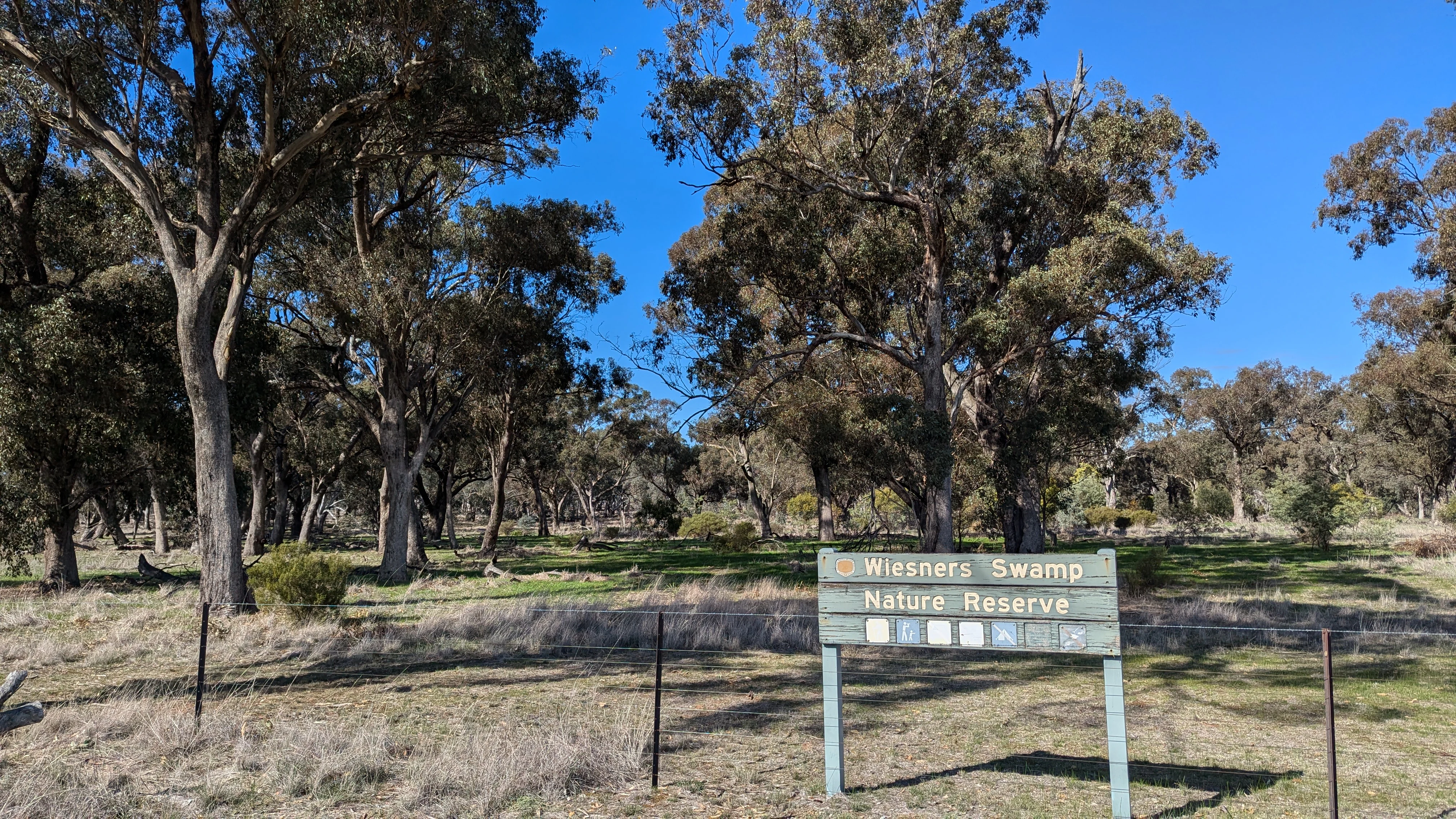
A wooden entrance sign for Wiesners Swamp Nature Reserve stands in front of a grassy woodland area with mature eucalyptus trees under a clear blue sky.
The entrance sign for Wiesners Swamp Nature Reserve in New South Wales.

Wiesners Swamp Nature Reserve history and protected-area timeline

Wiesners Swamp Nature Reserve lies in an area that is part of the broader country traditionally associated with the Wiradjuri people, although detailed information about the specific historic significance of the swamp to Aboriginal communities is limited. The swamp is thought to have been valued as a reliable source of water and game in a landscape where permanent fresh water was otherwise scarce.

European settlement of the surrounding district began in the 1830s with the arrival of pastoralists, and the swamp was incorporated into the broader Walla Walla Station run. In 1883, the area that would later become the nature reserve was excised from the station and set aside as two Crown forest reserves, an early recognition that these particular woodlands and wetlands had enduring value beyond immediate pastoral use. The locality came to be informally known as Wiesner Swamps from the early twentieth century, after the Wiesner family (pronounced "weezner") acquired the adjoining property.

By the 1970s, growing awareness of the wetland's ecological importance led to proposals to formalise the area's protection, first as a state game reserve and then as a nature reserve, recognising both its wetland values and its remnant woodland vegetation. The reserve was formally proclaimed in April 1996 under the management of what is now the NSW National Parks and Wildlife Service, bringing together these earlier layers of Crown reserve status into a single dedicated nature reserve.

Wiesners Swamp Nature Reserve landscape and geographic character

The landscape of Wiesners Swamp Nature Reserve is defined by contrast between a flat, low-lying wetland basin and slightly higher ground that rises just enough above the regular flood level to support woodland. The swamp itself occupies a shallow depression on the floodplain of Billabong Creek, near the upper catchment of Simmons Creek, giving the reserve a gentle basin-and-rim topography rather than any pronounced relief.

The wetland is ephemeral in character, lying dry at times and filling after sufficient rainfall and catchment runoff. Drainage enters the swamp mainly from the south-eastern and northern boundaries, while water leaves slowly to the west, producing a seasonal wet-dry cycle typical of inland floodplain systems in this part of New South Wales. The water table beneath the reserve lies several metres below the surface and is highly saline, influencing both the vegetation and the types of aquatic plants that can persist in the swamp.

Wiesners Swamp Nature Reserve ecosystems, habitats, and plant life

Ecologically, Wiesners Swamp represents a small but recognisable example of an inland floodplain habitat mosaic. The reserve's vegetation is dominated by river red gum woodland, with white box, grey box, yellow box and bulloak contributing additional large tree species on the slightly elevated ground. The mid-storey and under-storey layers are relatively limited, reflecting a long history of clearing and livestock grazing that has simplified the structural diversity of the woodland.

Within the swamp itself, native aquatic plants such as spiny flatsedge, common spikerush, rushes, red water-milfoil, water ribbons, swamp lily and blunt pondweed contribute to the wetland's vegetation cover. Around 116 plant species have been recorded in total across the reserve, although only a little over half of those are native, with the balance made up of introduced species that have become established since European settlement. The combination of river red gum wetland and adjoining box woodland gives the reserve a layered ecological character that links aquatic, wetland fringe and dry-land woodland communities within a compact footprint.

Wiesners Swamp Nature Reserve wildlife and species highlights

Wiesners Swamp supports a varied community of native fauna typical of the New South Wales South Western Slopes and adjacent Riverina. Approximately fifty bird species have been recorded in the reserve, drawing on both the wetland and the surrounding woodland. Waterbirds and wetland-associated species such as the Australian reed warbler, Australian white ibis, swamp harrier, white-necked heron, yellow-billed spoonbill and white-plumed honeyeater are part of the swamp's birdlife, while woodland birds including the brown treecreeper, dollarbird, mistletoebird, sacred kingfisher, tawny frogmouth and Australian zebra finch reflect the river red gum and box woodland habitats.

Mammals recorded in the reserve include the eastern grey kangaroo, common brushtail possum and common ringtail possum, while reptiles and amphibians documented on site include the eastern brown snake, lace monitor, spotted marsh frog and Peron's tree frog. As with much of inland New South Wales, the reserve also hosts a range of introduced pest species, including European rabbit, brown hare, European fox, feral cat, common starling, European carp and eastern mosquitofish, all of which influence ongoing management of the protected area.

Wiesners Swamp Nature Reserve conservation status and protection priorities

Wiesners Swamp Nature Reserve is protected as a strict nature reserve under IUCN Category Ia, the highest level of protection applied in the New South Wales reserve system, indicating that its primary purpose is the preservation of its natural values rather than recreation or tourism. Its conservation significance lies in safeguarding a small but representative example of ephemeral floodplain wetland and associated river red gum and box woodland in a region where these habitats have been extensively cleared and modified for agriculture.

The reserve protects a functioning seasonal wetland that still fills, drains and supports native aquatic vegetation, retaining natural hydrological behaviour in a landscape where floodplain wetlands have often been drained or heavily altered. It also conserves remnant examples of woodland that contribute to broader landscape connectivity and habitat for waterbirds, woodland birds and native mammals. Ongoing conservation management addresses the influence of introduced plant and animal species on the reserve's ecological character, working within the framework applied by the NSW National Parks and Wildlife Service.

Wiesners Swamp Nature Reserve cultural meaning and human context

The reserve lies within the broader cultural landscape of the Wiradjuri people, whose country extends across much of central and western New South Wales. While little detailed information exists about specific traditional uses or sites associated with Wiesners Swamp itself, the swamp is understood to have been an important reliable source of water and game in a landscape that would otherwise have been drier for much of the year. European pastoral expansion from the 1830s, the later establishment of Crown forest reserves in 1883, and the eventual proclamation of the nature reserve in 1996 together reflect successive layers of changing land use and growing recognition of the area's ecological values.

Top sights and standout views in Wiesners Swamp Nature Reserve

A compact floodplain wetland reserve with river red gum woodland dominating the overstorey, set in a shallow basin on the Billabong Creek plain. The reserve protects a functioning seasonal wetland that still fills and drains naturally, alongside patches of white box, grey box, yellow box and bulloak woodland on slightly higher ground. Its small size belies a meaningful diversity of native plants, waterbirds, woodland birds and mammals, and its strict nature reserve status reflects an emphasis on ecological preservation rather than visitor infrastructure.

Best time to visit Wiesners Swamp Nature Reserve

Because Wiesners Swamp is a strict nature reserve managed primarily for ecological protection rather than visitor recreation, the timing of any visit is best considered in terms of the seasonal character of the landscape rather than peak tourist periods. The ephemeral wetland is most pronounced following wetter periods, when the swamp fills and waterbirds and wetland-associated species are likely to be more visible. Drier periods expose more of the basin and the surrounding river red gum and box woodland, making woodland birdlife and other terrestrial wildlife easier to observe. Cooler months generally provide more comfortable conditions for being outdoors in inland New South Wales, while the warmer months emphasise the contrast between dry floodplain ground and any remaining standing water in the swamp.

Monthly climate preview

Long-term monthly temperature averages and precipitation rates for New South Wales

Wiesners Swamp Nature Reserve Climate Normals and Temperature Patterns

Historical data records monthly temperature swings from warm maximums to sub-zero minimums alongside steady daily precipitation at a representative reserve coordinate. Examining the full twelve-month profile reveals complete climatic rhythms across the protected landscape.
Annual mean16 °C
7 °C25 °C
Jan25°
Feb24°
Mar21°
Apr16°
May11°
Jun
Jul
Aug
Sep11°
Oct15°
Nov19°
Dec23°
Warmest month
January

25.4 °C

Coolest month
July

7.3 °C

Wettest month
June

1.8 mm/day

Driest month
April

1.1 mm/day

Park location guide

Geography guide, regional context, and park location map for Wiesners Swamp Nature Reserve

Wiesners Swamp Nature Reserve park geography, regions, and map view in Australia

Understand where Wiesners Swamp Nature Reserve sits in Australia through a broader geographic reading of the surrounding landscape, nearby location context, and its mapped position within the national park landscape.

How Wiesners Swamp Nature Reserve fits into Australia

Australia is a constitutional monarchy and federal parliamentary democracy comprising six states and ten territories. With a population of nearly 28 million, it is one of the world's most urbanised countries, with most people concentrated on the eastern seaboard. The country has a high Human Development Index and is known for its cultural diversity, ancient Aboriginal heritage, and unique wildlife.

Wider geography shaping Wiesners Swamp Nature Reserve in Australia

Australia occupies the entire Australian continent, the island of Tasmania, and numerous smaller islands. It is the world's flattest and driest inhabited continent, featuring vast deserts in the interior (the Outback), tropical rainforests along the eastern coast, and a coastline bordering the Indian and Pacific Oceans.

Map view of Wiesners Swamp Nature Reserve

Use this park location map to pinpoint Wiesners Swamp Nature Reserve in Australia, understand its exact geographic position, and read its mapped placement within the surrounding landscape more clearly.

Pigeon | © OpenStreetMap contributors

Location context for Wiesners Swamp Nature Reserve

New South Wales

Visual exploration of floodplain wetlands, river red gum woodlands, and protected terrain.

Wiesners Swamp Nature Reserve Photos and Landscape Scenery

Visual records capture the distinctive ephemeral basin and river red gum woodlands that define Wiesners Swamp Nature Reserve. Photographic documentation reveals the seasonal wet and dry cycles of the Billabong Creek floodplain.

A wooden entrance sign for Wiesners Swamp Nature Reserve stands in front of a grassy woodland area with mature eucalyptus trees under a clear blue sky.

Park atlas

Compare surrounding regional geography and connected floodplain ecosystems

Explore Protected Areas and Parks Near Wiesners Swamp Nature Reserve

Browsing other protected areas near Wiesners Swamp Nature Reserve reveals broader ecological patterns across the South Western Slopes. Continuing into adjacent regional reserves provides valuable context on ephemeral wetlands and river red gum woodlands.
National parkNew South Wales
About 29 km away#1 closest

Southeast

Benambra National Park: New South Wales Protected Area and Great Yambla Range Map

Explore mapped terrain and woodland ecosystems.

Benambra National Park serves as a key protected area in New South Wales, preserving crucial white box and Red Box woodland communities against a backdrop of the Great Yambla Range's dramatic topography. This national park is significant for its role in conserving habitat for at least twelve threatened bird species and its unique geological features, including cliff faces and flat-topped peaks. Understanding the park's mapped boundaries and its place within the South West Slopes region offers valuable context for geographic discovery and the study of Australia's natural landscapes.

Area
13.99 km²
Established
2001
IUCN
II
Relief
Mixed relief
National parkAustralia
About 50 km away#2 closest

South

Chiltern-Mt Pilot National Park: Box-Ironbark Forest & Mapped Landscape

Explore its protected areas and regional geographic context.

Chiltern-Mt Pilot National Park preserves a significant portion of Victoria's box-ironbark forest, an ecosystem vital for threatened species and rich biodiversity. This park showcases varied terrain, from sedimentary hills to granite landscapes, offering a compelling subject for geographic study. Understand its mapped extent and its role within the broader regional geography, providing deep insights for atlas-based exploration.

Area
215.6 km²
Established
2002
IUCN
II
Relief
Mixed relief
Watercolor painting depicting a panoramic view of rolling hills with scattered trees and soft, warm-toned washes of green and pink against a white background.
Nature reserveNew South Wales
About 54 km away#3 closest

East

Nest Hill Nature Reserve: Geographic Overview and Protected Woodland Mapping

Inland New South Wales temperate woodland conservation and landscape analysis

Located between Holbrook and Wagga Wagga, Nest Hill Nature Reserve preserves a significant tract of dry eucalypt woodland. The area features broad ridges and gentle slopes that reflect the transitional landscape of the South Western Slopes. This protected site remains a key reference point for understanding woodland biodiversity recovery and the long term stewardship of former timber harvesting lands in Australia.

Area
7.59 km²
Established
2001
IUCN
Ia
Relief
Upland
National parkNew South Wales
About 56 km away#4 closest

West

Murray Valley National Park: Explore its Mapped Boundaries and Regional Geography in New South Wales

Protected landscape identity and geographic context.

Gain a structured understanding of Murray Valley National Park, a designated national park within New South Wales. This detail page provides essential geographic context, highlighting the park's mapped boundaries and its significance as a protected natural landscape. Utilize this entry point for comprehensive atlas-based exploration of its unique regional setting and terrain.

Area
416.01 km²
Established
2010
IUCN
II
Relief
Lowland
National parkNew South Wales
About 61 km away#5 closest

Northeast

Livingstone National Park: National Park Protected Landscape and Geographic Context

Mapped terrain and protected area discovery for this New South Wales park.

Investigate Livingstone National Park as a key protected natural area in New South Wales. This detail entry offers insights into its mapped boundaries, regional geographic setting, and landscape character. Explore how this national park contributes to the broader atlas of Australian protected lands and understand its distinct natural terrain through detailed geographic data.

Area
19.19 km²
Established
2001
IUCN
II
Relief
Mixed relief
National parkNew South Wales
About 66 km away#6 closest

East

Woomargama National Park: National Park Protected Area with Mapped Landscape Identity

Discover the geographic context and park boundaries.

Woomargama National Park serves as a distinct entity for geographic exploration within New South Wales. As a designated national park, its protected landscape identity is integral to understanding the regional map. This profile facilitates detailed study of its position, natural terrain context, and role within Australia's network of conservation areas, providing structured data for atlas-based discovery.

Area
241.85 km²
Established
2001
IUCN
II
Relief
Upland
National parkAustralia
About 70 km away#7 closest

Southwest

Warby-Ovens National Park: Protected Landscape and Geographic Atlas Entry

Discover its Box-Ironbark forests and mapped regional terrain.

Warby-Ovens National Park is a protected national park situated in northeastern Victoria, Australia, covering 14,655 hectares of distinctive landscape. It is internationally recognized as an Important Bird Area, primarily for its significant Box-Ironbark forest ecosystem that supports numerous threatened woodland bird species. The park's geography features low granite hills and rolling terrain, with the Ovens River flowing through its northern section. This detail page provides structured information on its protected boundaries, natural landscape characteristics, and its place within regional geography.

Area
146.55 km²
Established
2010
IUCN
II
Relief
Upland
Nature reserveNew South Wales
About 73 km away#8 closest

Northwest

Lake Urana Nature Reserve: Geographic Atlas and Protected Area Mapping in Riverina

Inland salt-lake systems and dry box-pine woodland habitats

Lake Urana Nature Reserve functions as a representative protected zone within the Riverina region of New South Wales. The landscape transitions from the ephemeral salt-lake shoreline to native box-pine forests. This atlas entry details the protected boundaries and ecological characteristics of these arid-adapted inland plant communities and their role within the wider plains habitat network.

Area
3.02 km²
Established
1996
IUCN
Ia
Relief
Lowland

Common questions about visiting, size, designation, and location context for Wiesners Swamp Nature Reserve

Wiesners Swamp Nature Reserve FAQs for park facts, access, geography, and protected area context

Find quick answers about Wiesners Swamp Nature Reserve, including protected-area facts, park geography, trail and visitor context, and how the park fits into its surrounding country and regional landscape.
MoriAtlas Explorer

Continue Your Protected Areas Search Across the Global Atlas

Deepen your exploration by continuing the structured search for national parks and protected areas worldwide. Utilize the comprehensive filtering capabilities to compare different conservation landscapes and refine your understanding of global park geography. Discover more about the distribution and characteristics of protected natural areas.

Global natural geography