
Mori Atlas logo
Nature reserveWinzerwiese und Gosebruch

Discover the geographic terrain of this ecologically significant valley in Saxony

Winzerwiese und Gosebruch Nature Reserve: A Detailed Map and Protected Landscape Overview

(Naturschutzgebiet Winzerwiese und Gosebruch)

Winzerwiese und Gosebruch represents a compact and ecologically vital protected area situated within a small tributary valley of the Elbe in Sachsen. This nature reserve hosts an intricate mosaic of habitats, including saturated wet meadows, marshy floodplain woodlands, and adjacent dry forest slopes. The mapped terrain illustrates the transition between these contrasting vegetation zones, highlighting the significance of the Gosebach stream as a central hydrological driver within this protected Saxon landscape.

nature reserveSaxonywet meadowPfeifengras meadowmarsh forestfloodplain forest
Digital illustration of a forest scene with stylized trees, a small pool of water in the middle ground, and a tree stump in the foreground, rendered in a palette of light greens, yellows, and soft pinks.

Winzerwiese und Gosebruch

Nature reserve

Park overview

Structured park overview, official facts, and landscape profile for Winzerwiese und Gosebruch

Winzerwiese und Gosebruch park facts, protected area profile, and essential visitor context

Review the core facts for Winzerwiese und Gosebruch, including designation, size, terrain, visitor scale, habitats, and operating context in one park-focused overview.

About Winzerwiese und Gosebruch

Winzerwiese und Gosebruch is a compact nature reserve that captures one of the more botanically rich stretches of the Gosebach valley in Saxony. Despite covering only about 11.6 hectares, the area combines several distinct habitat types that together support an unusually diverse plant community. The landscape is shaped by a small tributary that has carved a gentle valley north of Naundörfel, allowing wet meadows, marshy woodlands, floodplain forests, and drier forested slopes to occur in close proximity.

The Winzerwiese meadow forms the ecological heart of the reserve. It functions both as an open meadow habitat and as a refuge for plant species whose distribution patterns carry broader phytogeographical meaning, particularly species associated with cooler, more continental, or formerly more widespread grassland conditions. These botanical values are the main reason the area earned formal protection and remain the reason the reserve continues to attract botanical interest.

Beyond its meadow habitats, the reserve includes wooded sections that reflect the valley's hydrological gradients. Wet alder-dominated woods and marsh communities occupy the lowest, wettest parts of the valley, while slightly elevated terrain supports drier forest types. This vertical and hydrological layering gives the small site considerable ecological variety.

Administratively, the area lies within the Gemeinde Diera-Zehren in the Landkreis Meißen and forms part of the broader Riesaer Elbtal and Seußlitzer Elbhügelland landscape protection zone. Its integration into the EU Natura 2000 network as an FFH area reinforces its conservation relevance, even though its size is modest by European standards.

Quick facts and research context for Winzerwiese und Gosebruch

Winzerwiese und Gosebruch is a Saxon nature reserve of approximately 11.6 hectares located in the Landkreis Meißen, north of Naundörfel. It was originally designated on 11 September 1967 and re-established under modern federal German law in 2006, with a later amendment in 2007. The reserve carries the designation D 03 and is also recorded in the World Database on Protected Areas under ID 166334.

Protection and recognition

Structured conservation records and official protected area data

Winzerwiese und Gosebruch Protection Status and Designated Area Records

Winzerwiese und Gosebruch conservation records compile verified protection status and administrative designation metrics. Structured protected area details provide clear insight into registered geographical boundaries and international database identifiers.

Protection details

WDPA ID
166334
Park context

Deeper park guide and search-rich context for Winzerwiese und Gosebruch

Winzerwiese und Gosebruch history, landscape, wildlife, and travel context

Explore Winzerwiese und Gosebruch through its history, landscape character, ecosystems, wildlife, conservation priorities, cultural context, and seasonal travel timing in a structured park guide built for atlas discovery and search intent.

Why Winzerwiese und Gosebruch stands out

The reserve is best known for its concentration of floristically important wet-meadow plants, including white cinquefoil, Nordic bedstraw, Siberian iris, great masterwort, and columbine-leaved meadow-rue, which give the Winzerwiese meadow strong phytogeographical significance. Its compact mosaic of wet meadows, marsh woods, floodplain forest, and dry woodland on a small tributary valley is also a defining feature of the site.
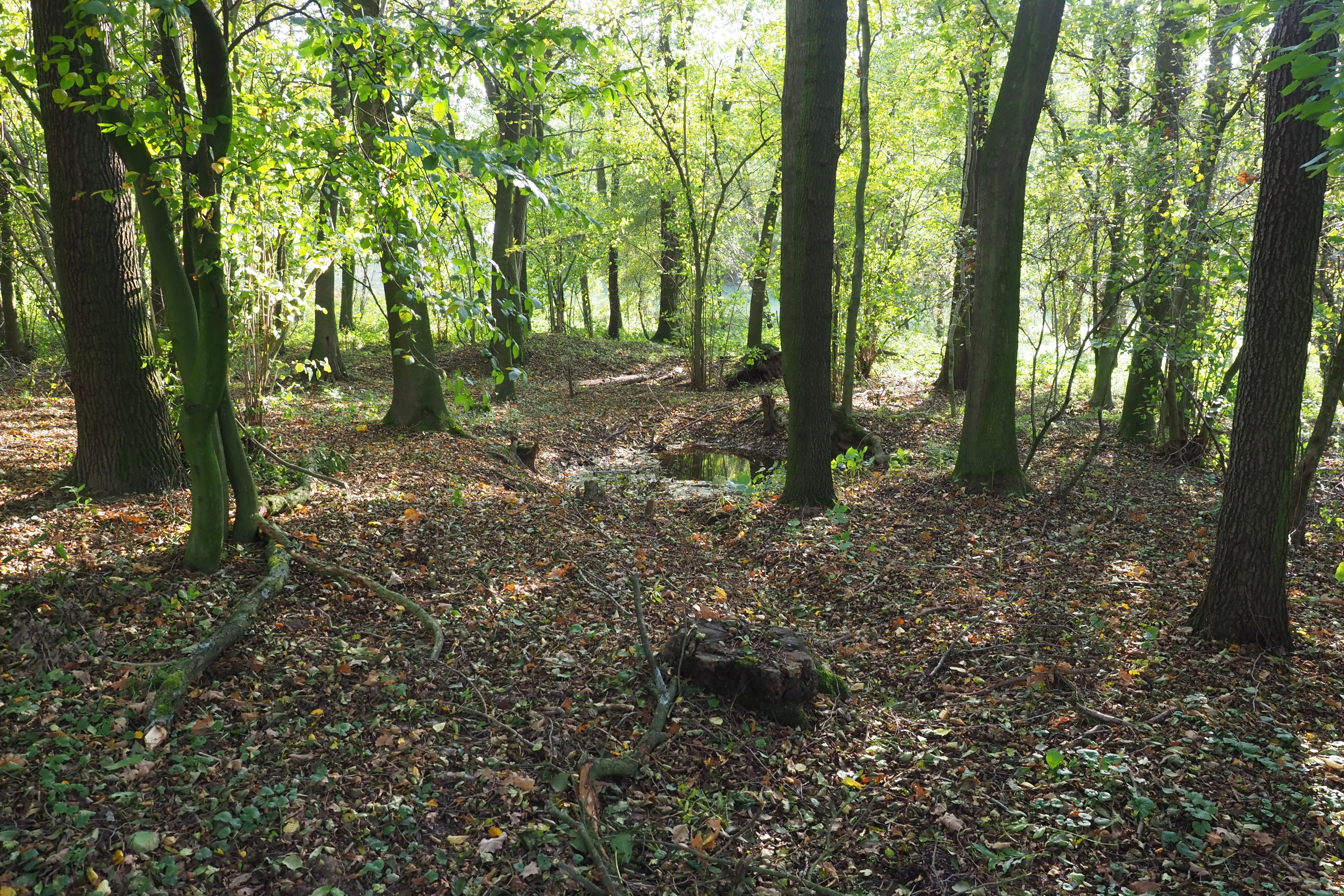
A view into a woodland area with mature trees and a forest floor covered in autumn leaves and scattered debris.
A shaded view of the woodland landscape within the Winzerwiese und Gosebruch nature reserve.

Winzerwiese und Gosebruch history and protected-area timeline

The area now known as Winzerwiese und Gosebruch received its first formal protection on 11 September 1967, when the chairman of the Landwirtschaftsrat of the German Democratic Republic issued Decree No. 3 on nature reserves, establishing the site under East German conservation law. This made it one of the earlier formally designated nature reserves in what is today the Free State of Saxony, and the designation reflects the GDR-era interest in protecting representative wetland and meadow habitats.

After German reunification, the site's legal basis was updated to fit the federal conservation framework. On 6 January 2006 the Regierungspräsidium Dresden issued a new ordinance that transferred the protection into current German law, and this ordinance was later amended on 13 April 2007. The reserve's modern identifier, D 03, dates from this re-establishment phase.

In parallel, the site's ecological relevance led to its inclusion as part of the EU-wide Natura 2000 network through designation as the FFH area no. 4746-304 'Winzerwiese'. This European-level recognition reflects the continuing botanical importance of the meadow and its surrounding habitats and connects the reserve to broader European biodiversity conservation goals.

Winzerwiese und Gosebruch landscape and geographic character

The landscape of Winzerwiese und Gosebruch is defined by a small valley section of the Gosebach, a tributary in the Elbe drainage system in Saxony. The valley floor hosts the central Winzerwiese meadow, which opens into marshy and grassy flats that periodically retain water, while the slopes and fringes rise gently into forested terrain. The combination of stream corridor, wet meadow, and wooded slopes gives the small area a varied topographic character despite its modest size.

Hydrology is a key shaping factor of the site. The Gosebach and its associated moisture conditions create the saturated soils that support the wet meadows and the alder-rich, marsh-like woodlands of the lowest parts of the valley. Slightly higher and better-drained positions carry drier deciduous forest, producing a patchwork of contrasting microhabitats within a short distance.

The reserve lies within the broader Elbe-region landscape that includes the Riesaer Elbtal and the Seußlitzer Elbhügelland. While these surrounding landscape features belong to the larger protected countryside rather than to the reserve itself, they provide a wider context of river-valley and gentle hilly terrain that frames the small Gosebach valley.

Winzerwiese und Gosebruch ecosystems, habitats, and plant life

The reserve protects a remarkably compressed mosaic of habitat types for its size. Open habitats include wet meadows and moist grasslands, with the Winzerwiese itself functioning as a species-rich Pfeifengras-style meadow influenced by traditional management. These open communities transition into marsh forest, floodplain forest, and dry forest on the well-drained slopes, creating ecological continuity between meadow, marsh, and woodland within just a few hectares.

The botanical importance of the meadows is the standout ecological feature of the site. Several species found here have phytogeographical significance, meaning their presence tells a wider story about historical plant distributions, refugia, and relict conditions in central European grasslands. The combination of such species in one small valley makes the reserve a disproportionately valuable site for botanical conservation in Saxony.

Winzerwiese und Gosebruch wildlife and species highlights

Wildlife information in the available sources is limited and focused on the botanical and habitat values rather than on animal species. As the reserve contains wet meadows, marsh, and mixed deciduous forest, it is ecologically suited to support typical Saxon lowland-valley fauna, such as meadow birds, amphibians associated with wet depressions, and small mammals of hedgerow and woodland edges, but the source material does not provide specific species claims that can be relied on.

Winzerwiese und Gosebruch conservation status and protection priorities

Winzerwiese und Gosebruch is ecologically significant well beyond its size because it combines high plant-species diversity with formal protection at multiple levels. As a German Naturschutzgebiet it is legally safeguarded against damaging land-use change, and as an FFH area within the Natura 2000 network it is integrated into the European Union's framework for habitat protection.

The reserve's conservation value lies heavily in its floristic richness. The presence of plant species of phytogeographical and floristic-historical importance in a small but well-managed meadow complex makes the area an important reference site for understanding and conserving characteristic Saxon wet-meadow vegetation. Its embedding within the larger Riesaer Elbtal and Seußlitzer Elbhügelland landscape protection area further strengthens its role in maintaining ecological connectivity in the Elbe tributary region.

Top sights and standout views in Winzerwiese und Gosebruch

The reserve's strongest points of distinction are its small but exceptionally species-rich wet meadow and its compact mosaic of contrasting woodland types along the Gosebach valley. The combination of historical protection dating back to 1967, modern Natura 2000 recognition, and the presence of floristically significant plant species gives this modest site a notable place in Saxony's network of protected areas.

Best time to visit Winzerwiese und Gosebruch

The meadows of Winzerwiese und Gosebruch, like other wet-grassland reserves in central Europe, are generally most expressive in late spring and early summer when meadow herbs and characteristic species such as Siberian iris and great masterwort are in bloom. Woodland and marsh sections remain green and structurally interesting across the warmer months. Because the source material does not provide detailed access guidance, visitors should rely on the Saxon conservation authority's general rules for accessing small nature reserves, which typically prioritize low-impact visits that avoid disturbing meadow vegetation.


Monthly climate preview

Long-term representative measurements showing monthly temperature and precipitation rhythms

Winzerwiese und Gosebruch Climate Normals, Annual Temperature and Precipitation

Representative coordinate records from 1991 to 2020 detail the measured annual temperature and precipitation rhythm across Winzerwiese und Gosebruch. Examining the complete twelve-month climate normals provides deeper context for long-term meteorological patterns at this location.
Annual mean8 °C
-2 °C19 °C
Jan-2°
Feb-1°
Mar
Apr
May13°
Jun17°
Jul19°
Aug19°
Sep14°
Oct
Nov
Dec-1°
Warmest month
July

19.1 °C

Coolest month
January

-1.8 °C

Wettest month
July

2.8 mm/day

Driest month
April

1.3 mm/day

Park location guide

Geography guide, regional context, and park location map for Winzerwiese und Gosebruch

Winzerwiese und Gosebruch park geography, regions, and map view in Germany

Understand where Winzerwiese und Gosebruch sits in Germany through a broader geographic reading of the surrounding landscape, nearby location context, and its mapped position within the national park landscape.

How Winzerwiese und Gosebruch fits into Germany

Germany is a federal republic in Western and Central Europe with a population of over 83 million across sixteen constituent states. It is Europe's largest economy by nominal GDP and a major global exporter and importer. The capital is Berlin, and the country borders Denmark, Poland, Czech Republic, Austria, Switzerland, France, Luxembourg, Belgium, and the Netherlands.

Wider geography shaping Winzerwiese und Gosebruch in Germany

Germany is located in Western and Central Europe, spanning 357,022 km². It borders Denmark to the north, Poland and the Czech Republic to the east, Austria and Switzerland to the south, and France, Luxembourg, Belgium, and the Netherlands to the west. The country has coastlines on the Baltic Sea and North Sea to the north, with the Alps located in the southern region.

Map view of Winzerwiese und Gosebruch

Use this park location map to pinpoint Winzerwiese und Gosebruch in Germany, understand its exact geographic position, and read its mapped placement within the surrounding landscape more clearly.

Pigeon | © OpenStreetMap contributors

Location context for Winzerwiese und Gosebruch

Sachsen

Visual exploration of wet meadows, stream corridors, and diverse habitats

Winzerwiese und Gosebruch Photos, Scenery, and Protected Valley Landscapes

Photographic views reveal the varied terrain, damp meadows, and marshy woodland patches that define the protected environment of Winzerwiese und Gosebruch. Examining these visual records helps researchers and visitors understand the distinctive stream valley ecology and plant habitats across the reserve.

A view into a woodland area with mature trees and a forest floor covered in autumn leaves and scattered debris.

Park atlas

Compare adjacent river valleys and connected conservation areas across Saxony.

Other Parks Near Winzerwiese und Gosebruch and Surrounding Regional Protected Landscapes

Browse protected areas near Winzerwiese und Gosebruch to evaluate related valley ecosystems and regional river habitats. Exploring adjacent nature reserves expands geographic context and deepens comparative analysis of Saxon conservation landscapes.
A soft, light-toned watercolor painting of a low, rolling landscape with green hills, sparse vegetation, and a suggestion of wetland or pond in the foreground.
Nature reserveSachsen
About 4.5 km away#1 closest

Northwest

Seußlitzer und Gauernitzer Gründe: Protected Nature Reserve Map and Landscape Overview

Regional geography and habitat boundaries in the Sachsen Elbe valley.

Spanning steep slopes and narrow brook valleys on both sides of the Elbe, Seußlitzer und Gauernitzer Gründe is a defining nature reserve in Sachsen. This protected area supports a diverse mix of dry herbaceous vegetation and mature deciduous forest, serving as a critical component of the local ecological network within the broader Upper Elbe landscape.

Area
3.57 km²
Established
2013
IUCN
IV
Relief
Upland
Nature reserveSaxony
About 11 km away#2 closest

West

Trockenhänge südöstlich Lommatzsch: A Protected Dry-Slope Landscape in Saxony, Germany

Mapping rare grasslands and oak woodland habitats

Trockenhänge südöstlich Lommatzsch encompasses a unique network of non-contiguous parcels across the Ketzerbach valley. Formed on resilient Meißner monzonite bedrock, these sheltered slopes support threatened plant communities and high-value invertebrate habitats, standing as a critical protected fragment amidst the surrounding intensive agricultural landscape of Saxony.

A horizontal watercolor illustration showing a calm pond in the foreground, with lush green vegetation on the banks and rolling hills in the background under a soft sky.
Nature reserveMeißen
About 15 km away#3 closest

Southeast

Dippelsdorfer Teich Nature Reserve: Geographic Insights and Landscape Context

Historic Saxon pond management and regional protected landscape.

The Dippelsdorfer Teich serves as a primary example of historical pond construction and nature protection in the northern Dresden countryside. This 69 hectare reservoir captures a blend of ecological, cultural, and recreational values within the Meißen region. Users can examine its physical layout, the dam structure, and the integration of heritage transport within this managed lowland environment.

Area
0.69 km²
Established
1528
Relief
Lowland
Scope
Terrestrial
A watercolor painting showing a calm pond with a small island of green trees and distant rolling hills under a soft pink and yellow sky.
Nature reserveMeißen District
About 15 km away#4 closest

East

Frauenteich Moritzburg: Mapping the Protected Wetland Landscapes of Meißen District

Glacial pond basins and diverse forest habitats in Saxony.

Frauenteich Moritzburg serves as a core component of Saxony's pond landscape, protecting a rich sequence of shoreline vegetation and open water. Its geography reflects the results of ancient glacial activity, creating a unique environment where sandy ridges and wet meadows coexist. This nature reserve provides essential refuge for bird populations, making it a focal point for understanding the natural, protected terrain within the broader Meißen District environment.

Area
2.02 km²
Established
1954
IUCN
IV
Relief
Lowland
A soft watercolor painting depicting a pale, hazy landscape with green grassy fields, light green trees, and distant faint mountains under a pastel sky.
Protected areaSaxony
About 19 km away#5 closest

Northwest

Gohrischheide und Elbniederterrasse Zeithain: Geography and Protected Area Overview

Analyzing the inland dunes and dry heath landscape of the Elbe river terrace

Discover the unique geography of Gohrischheide und Elbniederterrasse Zeithain in Saxony, a protected area known for its expansive inland dunes and dry heath habitats. This region represents a rare combination of post-glacial sand landscapes and semi-open forest mosaics that reflect long-term ecological evolution and distinct regional environmental conditions.

Area
28.47 km²
Established
2011
Relief
Lowland
Climate
Temperate
Nature reserveSachsen
About 21 km away#6 closest

East

Waldmoore bei Großdittmannsdorf: A Protected Wetland Landscape in Sachsen, Germany

Mapping forest mires and rare swamp woodland habitats

Waldmoore bei Großdittmannsdorf represents a carefully maintained nature reserve in eastern Germany, spanning roughly 93 hectares of forest mire and bog structures. The site supports a rare transition of swamp woodland, sedge-rich wet stands, and spring flushes within the Laußnitzer Heide. As a designated Natura 2000 area, it plays a key role in safeguarding regional wetland connectivity and providing a refuge for specialist flora and fauna in the Saxon landscape.

Area
0.935 km²
Established
2000
IUCN
IV
A horizontal watercolor painting showing a soft, atmospheric wetland scene with green meadows, tall grasses, distant tree lines, and a pale pink and yellow sky.
Nature reserveBrandenburg
About 25 km away#7 closest

North

Kleine Röder Nature Reserve: Mapped Wetland Geography and Protected Landscape in Brandenburg

A vital Elbe-Mulde lowland corridor near Bad Liebenwerda

The Kleine Röder Nature Reserve functions as a major ecological link in northeastern Germany, protecting a 385 hectare mosaic of fens, wet meadows, and alluvial forests. This site is defined by its water-dominated terrain and its role as a habitat corridor in the Elbe-Mulde lowland, encompassing both rare wetland flora and the historic Kosilenzien Slavic ringwall within its official boundaries.

Area
3.65 km²
Established
2011
IUCN
IV
Nature reserveFreistaat Sachsen
About 27 km away#8 closest

Southeast

Windberg Nature Reserve: Mapping the Forested Ridge and Protected Landscape of Saxony

Geology, mining heritage, and protected oak-beech forest ecosystems

Windberg serves as the prominent local landmark for Freital, defined by its elongated forested plateau and complex tectonic geography. This nature reserve offers a study in the intersection of environmental conservation and human industrial history, featuring Saxony's deepest cave and varied habitats within the eastern Ore Mountains foothills.

Established
1967
Relief
Mountain
Climate
Temperate
Access
Easy access

Common questions about visiting, size, designation, and location context for Winzerwiese und Gosebruch

Winzerwiese und Gosebruch FAQs for park facts, access, geography, and protected area context

Find quick answers about Winzerwiese und Gosebruch, including protected-area facts, park geography, trail and visitor context, and how the park fits into its surrounding country and regional landscape.
MoriAtlas Explorer

Continue Your Protected Areas Search Across the Global Atlas

Deepen your exploration by continuing the structured search for national parks and protected areas worldwide. Utilize the comprehensive filtering capabilities to compare different conservation landscapes and refine your understanding of global park geography. Discover more about the distribution and characteristics of protected natural areas.

Global natural geography