
Mori Atlas logo
Nature reserveWipperaue Eulenbecke

Analyzing the ecological corridor of the upper Wipper and its diverse floodplain fragments

Wipperaue Eulenbecke Nature Reserve: Mapped Protected Landscapes in Oberbergischer Kreis

(Naturschutzgebiet Wipperaue Eulenbecke)

Wipperaue Eulenbecke serves as a critical protected corridor within the Bergisches Land of North Rhine-Westphalia, preserving a near-natural stretch of the upper Wipper headwaters. This nature reserve integrates shallow riffles, gravel banks, and wet meadows to sustain sensitive freshwater ecology across the Oberbergischer Kreis region. The protected area features a mosaic of alluvial forest, riparian woodland, and tributary valleys that anchor connected freshwater habitats within the broader Natura 2000 network.

nature reservefloodplainriparian woodlandheadwater streambrook habitatNatura 2000
A peaceful, illustrative depiction of a winding forest river surrounded by trees, ferns, and a tree stump, with a distant ridgeline under a soft sunset sky.

Wipperaue Eulenbecke

Nature reserve

Park overview

Structured park overview, official facts, and landscape profile for Wipperaue Eulenbecke

Wipperaue Eulenbecke park facts, protected area profile, and essential visitor context

Review the core facts for Wipperaue Eulenbecke, including designation, size, terrain, visitor scale, habitats, and operating context in one park-focused overview.

About Wipperaue Eulenbecke

Wipperaue Eulenbecke sits at the heart of a small but ecologically rich segment of the upper Wupper (locally called the Wipper) within the Bergisches Land, a low-mountain region shaped by slate ridges, mixed forests, and tightly meandering brooks. Although the reserve covers only about 21.9 hectares, its placement along a headwater stream gives it an outsized role in protecting floodplain connectivity on a floodplain otherwise fragmented by forestry, agriculture, and water infrastructure.

The reserve's principal focus is the riparian strip east of Marienheide, following the Wipper from the area west of Holzwipper along the Höfeler Landstraße to the southeastern edge of Fließwipper. The stream itself is narrow, generally no wider than two metres, and locally features gravel bars, shallow flats, and deeper pools. A reservoir pond near Holzwipper adds standing-water habitat and is partly connected to the Brucher Talsperre, an upstream reservoir that influences flow conditions in the broader catchment.

Two additional parcels broaden the ecological footprint beyond the main river valley: the Bocksiepen brook valley just north of the Brucher Talsperre and the lower section of the Neuenhauser Siefen northwest of Fließwipper. Together, these features preserve a chain of wet habitats across distance rather than within a single contiguous block, reflecting a landscape where small brook valleys and tributaries matter as much as the main channel.

Historically, much of the ground within the reserve was dominated by spruce plantations that did not match the hydrology or soils of a floodplain. Management has progressively removed portions of this non-native conifer cover to expand the remaining species-rich floodplain fragments, with peat mosses persisting as a particularly sensitive indicator of remnant floodplain conditions. The reserve is administered under a legally binding landscape plan by the lower landscape authority of the Oberbergischer Kreis, ensuring that future management continues to support habitat restoration rather than reverting to plantation use.

As part of the broader Wupper östlich Wuppertal Natura 2000 site, Wipperaue Eulenbecke functions less as a stand-alone wilderness and more as a stepping stone within a regional habitat network, linking headwater streams, floodplains, and wet meadows across municipal boundaries in the Bergisches Land.

Quick facts and research context for Wipperaue Eulenbecke

Wipperaue Eulenbecke is a designated nature reserve (Naturschutzgebiet) in Marienheide, Oberbergischer Kreis, North Rhine-Westphalia, designated in 2005 under official code GM-077. It sits at elevations between roughly 344 and 377 metres above sea level and covers about 21.9 hectares, forming a part of the larger 147 hectare Natura 2000 site along the upper Wupper.

Administratively, the reserve falls under the Untere Landschaftsbehörde Oberbergischer Kreis, with its protection grounded in a legally binding landscape plan. It straddles an area east of Marienheide's main village centre, following the Wipper from near Holzwipper to the edge of Fließwipper. Beyond the main valley strip, two detached parcels extend protection to the Bocksiepen brook valley north of the Brucher Talsperre and to the lower section of the Neuenhauser Siefen northwest of Fließwipper.

Protection and recognition

Documented terrestrial protection scope, management records, and formal status details

Wipperaue Eulenbecke Protection Status and International Recognition

Wipperaue Eulenbecke maintains a recorded terrestrial protection status governed by established conservation frameworks. Formal datasets compile official designation records and international recognition metrics to document the protected area profile.

Protection details

Protection scope
Terrestrial
Transboundary protection
No
WDPA ID
344819
Park context

Deeper park guide and search-rich context for Wipperaue Eulenbecke

Wipperaue Eulenbecke history, landscape, wildlife, and travel context

Explore Wipperaue Eulenbecke through its history, landscape character, ecosystems, wildlife, conservation priorities, cultural context, and seasonal travel timing in a structured park guide built for atlas discovery and search intent.

Why Wipperaue Eulenbecke stands out

The reserve is best known for protecting species-rich floodplain fragments, including small patches of alluvial forest where peat mosses occur, alongside a near-natural stretch of the upper Wipper (Wupper). Its mix of shallow riffles, gravel bars, and pools makes it a critical habitat for freshwater species such as the brook lamprey and the bullhead, while the surrounding riparian corridors support kingfishers and black storks. The combination of a regulated reservoir pond at Holzwipper, wet meadows, and a meandering headwater stream gives Wipperaue Eulenbecke a distinctive character among small NRW nature reserves. It is also recognised for the slow conversion of its spruce stands, which historically dominated much of the ground, into more ecologically appropriate floodplain woodland.
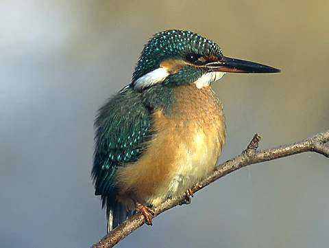
A close up view of a common kingfisher with iridescent blue and green feathers and an orange breast, perched on a thin, leafless branch against a soft, blurred background.
A common kingfisher perched on a bare branch within its natural habitat.

Wipperaue Eulenbecke history and protected-area timeline

Wipperaue Eulenbecke was placed under formal protection in 2005 through a legally binding landscape plan, bringing a stretch of the upper Wipper and its surrounding floodplain under the German Naturschutz framework. Its designation came as awareness grew of the ecological importance of small headwater reaches and the role floodplain fragments play in maintaining habitat networks in heavily modified low-mountain landscapes.

The reserve's history is shaped in large part by past land-use patterns within its boundaries. Large areas had been converted to spruce plantations over previous decades, often at the expense of more ecologically appropriate floodplain woodland and wet grassland. In the years surrounding and following designation, forest conversion efforts removed portions of these non-native conifer stands to give species-rich floodplain fragments room to expand and to support peat moss populations that depend on consistent floodplain moisture.

The reserve's integration into the larger Natura 2000 site Wupper östlich Wuppertal links its history to broader European conservation frameworks, recognising that the Wipper's near-natural structures, source reaches, and wet meadows contribute to continent-wide goals for freshwater and alluvial habitat protection.

Wipperaue Eulenbecke landscape and geographic character

The protected area follows a relatively narrow corridor through a mid-elevation stretch of the Bergisches Land, sitting between roughly 344 and 377 metres above sea level. Its dominant landform is the valley of the upper Wipper, a small, structurally diverse river with shallow runs across gravel bars, frictional flats, and small, deeper pools that together create an unusually varied channel morphology for a stream of this size.

The terrain around the main channel is shaped by floodplain flats and adjoining slopes that rise gently toward the surrounding wooded ridges. Wet meadows are scattered where the floodplain broadens, while steeper sections transition into forested hillside and, in some areas, into the spruce stands that have historically dominated parts of the site. The reservoir pond near Holzwipper adds an artificial but ecologically valuable element to the topography, partially integrating the valley with the larger Brucher Talsperre system upstream.

Two detached parcels extend this mosaic beyond the core river valley: the Bocksiepen brook valley north of the Brucher Talsperre, and the lower course of the Neuenhauser Siefen northwest of Fließwipper. Both extend the floodplain and brook environment into upper tributary catchments, creating a network of small moist valleys that visually and ecologically define the protected area despite its compact footprint.
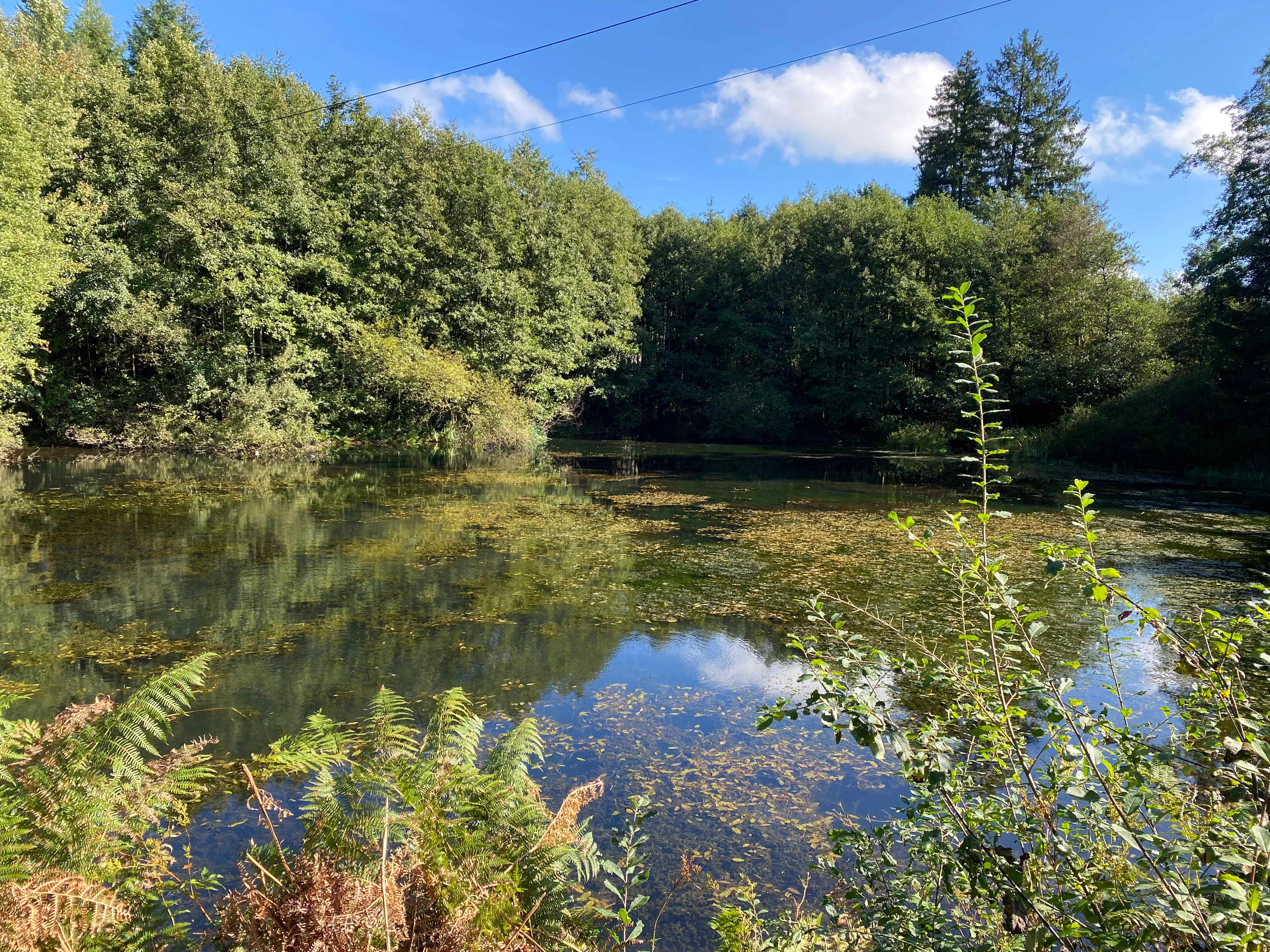
A calm mill pond surrounded by a dense, leafy deciduous forest under a bright blue sky with light clouds.
The Holzwipper mill pond in the Wipperaue Eulenbecke nature reserve.

Wipperaue Eulenbecke ecosystems, habitats, and plant life

The reserve protects a stack of floodplain and brook habitats anchored around the upper Wipper. Alluvial woodland fragments, including sections that retain peat moss species, form the most sensitive habitats within the protected perimeter, persisting only where hydrological conditions remain stable and disturbance from plantation forestry has been reduced.

Wet meadows and moist grassland occur where the floodplain opens up, providing transitional habitat between the riparian woods and the surrounding agricultural and forested land. These grasslands help maintain the moisture and nutrient regimes that support the floodplain fragments and offer distinct botanical communities, including scattered populations of water crowfoots such as the common water buttercup and shield-leaved pondweed relatives referencable in the area's botanical profile.

The Holzwipper reservoir adds a standing-water element to the ecosystem: a relatively undisturbed pond with abundant aquatic vegetation that supports both aquatic invertebrates and the wider food web tied to the river. The brook valleys of Bocksiepen and the Neuenhauser Siefen further extend the habitat spectrum into smaller tributary channels, where aquatic plants such as skullcap grow along margins.
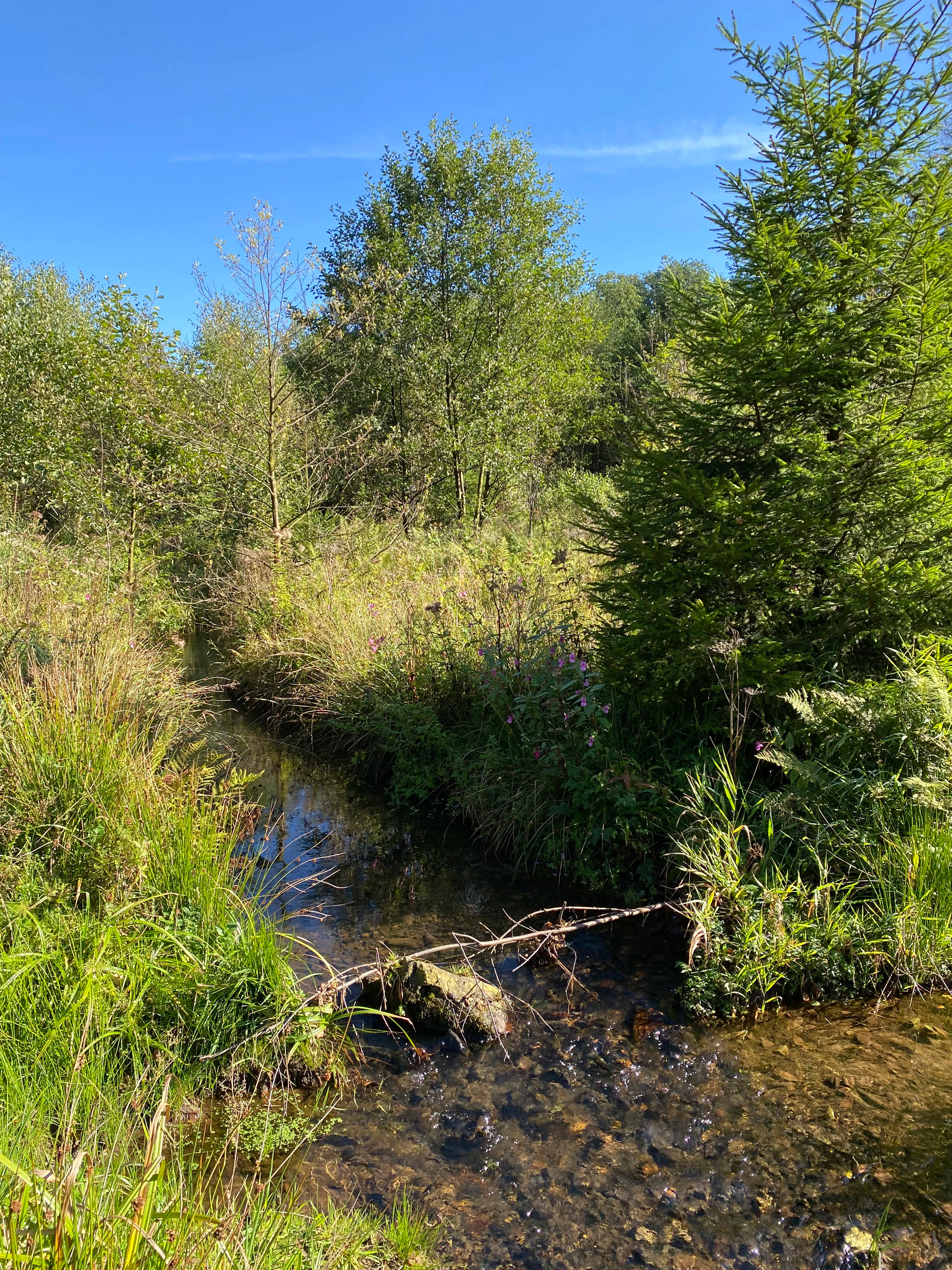
A small, clear stream flows through a lush, green riparian landscape with deciduous and coniferous trees under a clear blue sky.
The Wipper river flowing through the Wipperaue Eulenbecke nature reserve.

Wipperaue Eulenbecke wildlife and species highlights

Aquatic fauna is at the heart of the reserve's wildlife importance. The Wipper shelters the brook lamprey, a sensitive indicator species of clean, gravel-based headwater streams, as well as the bullhead, a small bottom-dwelling fish associated with structured, oxygen-rich brook habitats. These species depend directly on the near-natural channel morphology maintained through protection.

Birds associated with clean rivers and structured riparian corridors are also characteristic of the area. Kingfishers are particularly tied to the shallow, fish-rich stretch of the upper Wipper, while black storks occasionally use the wetter floodplain margins and adjoining woodland for foraging. The combination of standing water, flowing water, wet grassland, and woodland patches provides a wide foraging range within a small radius.

Invertebrate diversity adds a further layer to the ecological profile. Dragonflies such as the blauflügel-Prachtlibelle, a damselfly species tied to structured freshwater habitats, are resident in the area, reflecting the water quality and the mosaic of still and flowing water. The mix of wet meadows, aquatic plants, and forested edges supports a stable insect community that in turn underpins the food web for the reserve's fish and birdlife.

A close up underwater view of a European Brook Lamprey with a long, slender, brownish-grey body resting its head against a small brown stone on a sandy river bottom.
A European Brook Lamprey resting on a riverbed stone in the Wipperaue Eulenbecke nature reserve.

Wipperaue Eulenbecke conservation status and protection priorities

Wipperaue Eulenbecke is a recognised habitat and species management area at the European level, embedded within the Natura 2000 network through its inclusion in the larger Wupper östlich Wuppertal site, which links floodplain, brook, and source habitats across a significant stretch of the upper Wupper catchment.

The reserve's core conservation value lies in preserving the near-natural course of the upper Wipper, including its gravel beds, shallow flats, and pools, along with the surviving species-rich floodplain fragments that line its banks. Protection of these habitats directly underpins populations of freshwater species such as the brook lamprey and bullhead, while also maintaining conditions for sensitive plant indicators like peat mosses.

Management focuses on expanding and restoring these floodplain fragments by gradually removing previously dominant spruce plantations and on preserving wet meadows through continued low-intensity use. The reserve's role as a stepping stone within the broader Wupper östlich Wuppertal site enhances its conservation value, as floodplain species depend on connectivity across multiple protected patches rather than on single isolated sites.

Top sights and standout views in Wipperaue Eulenbecke

The standout qualities of Wipperaue Eulenbecke lie in the way a single small valley combines clean, structured headwater stream, seminatural floodplain woodland, and wet meadows, all within a heavily forested low-mountain region. The presence of rare freshwater species such as the brook lamprey and bullhead, together with seasonal visitors like the kingfisher and the black stork, gives the reserve an ecological depth that exceeds its modest size.

Equally distinctive is the reserve's transition from spruce-dominated forest to more appropriate floodplain vegetation, an active restoration story that reflects shifting attitudes toward land use along Germany's small river valleys. Its position within the Natura 2000 site Wupper östlich Wuppertal ties these local features to the larger goal of protecting connected freshwater habitats across the Bergisches Land.
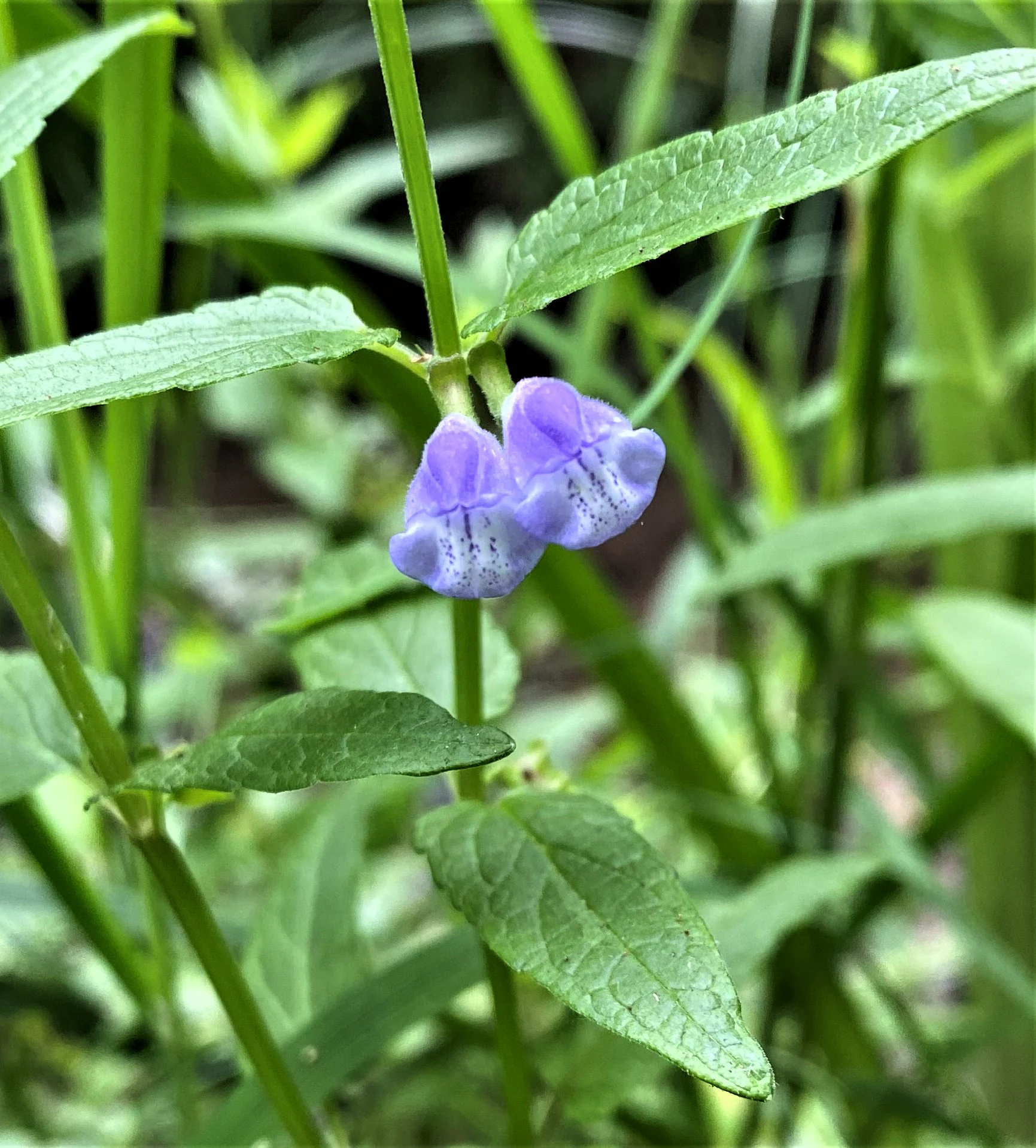
A close-up of a Common skullcap plant with two small, light purple, hooded flowers blooming among green leaves and stems.
Common skullcap, Scutellaria galericulata, in bloom.

Best time to visit Wipperaue Eulenbecke

The reserve's character shifts with the seasons in ways typical of central European low-mountain stream valleys. Spring brings high water levels and active growth along the wet meadows and floodplain fragments, while summer offers the most accessible conditions for observing dragonflies, aquatic vegetation, and the freshwater habitats around the Holzwipper pond.

Autumn highlights the seasonal wetland character of the meadows and the migratory activity of waterbirds moving along the Wupper system. Cooler months tend to be quieter, with low vegetation cover offering clearer views of the stream's structure, including its gravel banks and pools, though weather conditions can make wet sections of the trails and access paths more demanding.


Monthly climate preview

Long term monthly averages for temperature and precipitation rhythm

Wipperaue Eulenbecke Climate Normals and Annual Temperature Patterns

Representative coordinate records show average temperatures ranging from near freezing to warm midsummer maximums alongside consistent daily precipitation rates. Examining the full twelve month climate profile reveals detailed monthly shifts across the protected landscape.
Annual mean9 °C
0 °C18 °C
Jan
Feb
Mar
Apr
May13°
Jun16°
Jul18°
Aug18°
Sep14°
Oct
Nov
Dec
Warmest month
July

18.3 °C

Coolest month
January

0.3 °C

Wettest month
December

3 mm/day

Driest month
April

1.8 mm/day

Park location guide

Geography guide, regional context, and park location map for Wipperaue Eulenbecke

Wipperaue Eulenbecke park geography, regions, and map view in Germany

Understand where Wipperaue Eulenbecke sits in Germany through a broader geographic reading of the surrounding landscape, nearby location context, and its mapped position within the national park landscape.

How Wipperaue Eulenbecke fits into Germany

Germany is a federal republic in Western and Central Europe with a population of over 83 million across sixteen constituent states. It is Europe's largest economy by nominal GDP and a major global exporter and importer. The capital is Berlin, and the country borders Denmark, Poland, Czech Republic, Austria, Switzerland, France, Luxembourg, Belgium, and the Netherlands.

Wider geography shaping Wipperaue Eulenbecke in Germany

Germany is located in Western and Central Europe, spanning 357,022 km². It borders Denmark to the north, Poland and the Czech Republic to the east, Austria and Switzerland to the south, and France, Luxembourg, Belgium, and the Netherlands to the west. The country has coastlines on the Baltic Sea and North Sea to the north, with the Alps located in the southern region.

Map view of Wipperaue Eulenbecke

Use this park location map to pinpoint Wipperaue Eulenbecke in Germany, understand its exact geographic position, and read its mapped placement within the surrounding landscape more clearly.

Pigeon | © OpenStreetMap contributors

Location context for Wipperaue Eulenbecke

North Rhine-WestphaliaOberbergischer Kreis

Visual reference guide to floodplain habitats, headwater streams, and protected terrain

Wipperaue Eulenbecke Photos and Landscape Scenery

Visual documentation captures the natural character of Wipperaue Eulenbecke through detailed imagery of its meandering headwater streams and wet meadows. Photographic records reveal the distinctive topography of protected floodplain fragments and riparian woodland across the Bergisches Land.

A close up view of a common kingfisher with iridescent blue and green feathers and an orange breast, perched on a thin, leafless branch against a soft, blurred background.

A calm section of a river surrounded by dense green deciduous trees and riparian vegetation under a clear blue sky.

A calm mill pond surrounded by a dense, leafy deciduous forest under a bright blue sky with light clouds.

A small, clear stream flows through a lush, green riparian landscape with deciduous and coniferous trees under a clear blue sky.

A close up underwater view of a European Brook Lamprey with a long, slender, brownish-grey body resting its head against a small brown stone on a sandy river bottom.

A close up view of a metallic blue-winged damselfly perched on the green needle-covered branch of a coniferous tree.

A close-up of a Common skullcap plant with two small, light purple, hooded flowers blooming among green leaves and stems.

A small, calm river winding through a dense, mossy forest with ferns and tall deciduous trees along the banks.

A small, calm stream winds through a dense, green forest with dappled sunlight hitting the reflective water.

A view looking down into the calm, reflective water of a reservoir, showing patches of underwater aquatic plants and fallen leaves with reflections of surrounding trees on the surface.

Park atlas

Discover adjacent river valleys, regional nature reserves, and connected freshwater habitats in the surrounding Bergisches Land.

Explore Parks Near Wipperaue Eulenbecke And Related Protected Landscapes

Compare Wipperaue Eulenbecke with other protected areas across the Oberbergischer Kreis to understand regional floodplain ecology. Browsing adjacent river valleys and headwater reserves reveals wider ecological links throughout the mid-elevation landscape.
A soft watercolor illustration showing a misty, open wetland landscape with grassy foreground, a line of trees in the middle distance, and gentle hills in the background.
Nature reserveNordrhein-Westfalen
About 1.9 km away#1 closest

East

Nass- und Feuchtgrünlandkomplex östlich Holzwipper Protected Wet Grassland Nature Reserve

Examining riparian valley geography in the Oberbergischer Kreis.

The Nass- und Feuchtgrünlandkomplex östlich Holzwipper protects a rare, small-scale mosaic of wet meadow, sedge communities, and river-fringe vegetation. This nature reserve serves as an essential ecological anchor for damp valley systems in the Nordrhein-Westfalen region, offering a clear view of specialized botanical landscapes and stream-side terrain.

Area
0.023 km²
Established
1998
IUCN
IV
Nature reserveOberbergischer Kreis
About 3.6 km away#2 closest

West

Wupperaue bei Gogarten Nature Reserve: Protected River Valley and Riparian Habitat

Geographic overview of the Wipper river corridor in North Rhine-Westphalia

Located in the Oberbergischer Kreis, this nature reserve protects a seven hectare stretch of the Wipper valley. The landscape is characterized by alder riparian forests, steep river banks, and moist flood meadows that function as an essential biological stepping stone for riverine biodiversity.

Area
0.07 km²
Established
2005
IUCN
IV
Relief
Lowland
A flat, vector-style illustration of a valley with a winding path in the foreground, coniferous trees, a waterfall, and rocky cliffs under a light sky.
Nature reserveOberbergischer Kreis
About 7.7 km away#3 closest

Northwest

Ibachtal und Nebenbäche Nature Reserve: Geographic Overview and Protected Stream Landscape

Stream valley connectivity in the Oberbergischer Kreis

Trace the landscape of the Ibachtal und Nebenbäche nature reserve through its distinct stream valleys, alder gallery forests, and botanically diverse wet meadows. This area serves as a primary example of stream-based ecological protection in the Bergisches Land, characterized by narrow ravine-like tributaries and expansive floodplain grassland.

Area
0.268 km²
Established
2013
IUCN
IV
Watercolor painting of a rolling landscape with soft green hills, forest patches, and a winding stream.
Nature reserveGermany
About 16 km away#4 closest

West

Schwarzenbachtal Nature Reserve: Regional Protected Landscape and Stream Valley Atlas

A mapped overview of protected habitats in North Rhine-Westphalia

Schwarzenbachtal serves as a vital protected area in Germany, defined by its elongated brook valley and intricate transitions between wet meadows and dry grassland mosaics. As part of the Bergisches Land stream network, this nature reserve illustrates the ecological significance of small-scale valley landscapes and their role in regional conservation geography.

Area
0.082 km²
Established
2013
Relief
Upland
Climate
Temperate
Nature reserveNorth Rhine-Westphalia
About 16 km away#5 closest

West

Wupperaue bei Westenbrücke Nature Reserve Landscape and Geographic Mapping

Protected riparian floodplain in the Oberbergischer Kreis

This nature reserve protects a vital 2.3 kilometer segment of the Wupper river valley. Its landscape is characterized by a mosaic of wet meadows, alder and willow stands, and riparian corridors, providing a crucial stepping-stone habitat within the Hückeswagen area of North Rhine-Westphalia.

Area
0.318 km²
Established
2013
IUCN
IV
A soft watercolor illustration of a green valley with a central stream or river winding through meadows towards distant hills.
Nature reserveOberbergischer Kreis
About 18 km away#6 closest

Northwest

Leiverbachtal und Talhänge: Protected Stream Valley and Forest Habitat in Oberbergischer Kreis

Examining the geography of a Bergisches Land nature reserve

Leiverbachtal und Talhänge stands as a significant nature reserve within the Oberbergischer Kreis, defined by its near-natural meandering stream and diverse riparian ecosystem. The site offers a detailed look at floodplain meadows, slope forest transitions, and the ongoing shift toward broadleaf woodland within the German Mittelgebirg landscape.

Area
0.92 km²
Established
2006
IUCN
IV
Relief
Upland
A horizontal watercolor illustration depicting rolling hills, forest patches, and a soft, hazy valley against a white background.
Nature reserveNorth Rhine-Westphalia
About 19 km away#7 closest

West

Mausbachtal Nature Reserve in North Rhine-Westphalia: Protected Stream Valley and Forest Landscapes

Regional stream valley network and deciduous forest landscape

This protected area in the Oberbergischer Kreis offers a window into the Bergische Hochflächen topography. The reserve highlights a mosaic of near-natural beech forest, wet meadows, and floodplain woodland, forming an integral link in the regional stream network connected to the Große Dhünn.

Area
0.237 km²
Established
2013
IUCN
IV
Watercolor painting of a soft, rolling landscape with light green fields, scattered trees, and muted pink-toned hills.
Nature reserveNorth Rhine-Westphalia
About 19 km away#8 closest

Northeast

Naturschutzgebiet Oberes Elsetal: Protected Brook Valley Geography in North Rhine-Westphalia

Mapping riparian ecosystems and low mountain range stream habitats.

Naturschutzgebiet Oberes Elsetal offers a detailed look at the structural interplay between spring-fed brooks and adjacent marshy grasslands. This nature reserve in the Südsauerländer Bergland provides an instructive map of how riparian alder gallery woodland, oak-hornbeam forest, and wet meadow communities converge in a compact, highly specialized valley setting.

Area
0.053 km²
Established
1998
Relief
Upland
Scope
Terrestrial

Common questions about visiting, size, designation, and location context for Wipperaue Eulenbecke

Wipperaue Eulenbecke FAQs for park facts, access, geography, and protected area context

Find quick answers about Wipperaue Eulenbecke, including protected-area facts, park geography, trail and visitor context, and how the park fits into its surrounding country and regional landscape.
MoriAtlas Explorer

Continue Your Protected Areas Search Across the Global Atlas

Deepen your exploration by continuing the structured search for national parks and protected areas worldwide. Utilize the comprehensive filtering capabilities to compare different conservation landscapes and refine your understanding of global park geography. Discover more about the distribution and characteristics of protected natural areas.

Global natural geography