

Mori Atlas logo
Wildlife reserveWirrimbirra Sanctuary

A historic conservation landscape preserving rare native woodland and indigenous flora in southwestern Sydney

Wirrimbirra Sanctuary Protected Wildlife Reserve and Bargo Brush Woodland in New South Wales

Wirrimbirra Sanctuary represents a vital protected wildlife reserve located on the flat plateau of the Bargo area in New South Wales. This heritage-listed site safeguards a rare remnant of the original Bargo Brush, a woodland community historically significant as the location of the earliest recorded European sightings of the koala and the lyrebird. Spanning 95 hectares, the sanctuary serves as an essential ecological corridor and educational hub, maintaining extensive native plant gardens that link regional natural terrain.

flora sanctuarynative plant nurseryremnant bushlandBargo Brushenvironmental educationfield studies centre

Wirrimbirra Sanctuary

Wildlife reserve

Park overview

Structured park overview, official facts, and landscape profile for Wirrimbirra Sanctuary

Wirrimbirra Sanctuary park facts, protected area profile, and essential visitor context

Review the core facts for Wirrimbirra Sanctuary, including designation, size, terrain, visitor scale, habitats, and operating context in one park-focused overview.

About Wirrimbirra Sanctuary

Wirrimbirra Sanctuary sits on a quiet stretch of Remembrance Drive near Bargo, about 100 kilometres south of Sydney, and represents one of the most important surviving pieces of the once-vast Bargo Bush. The landscape it protects is a flat plateau woodland that has been substantially cleared from the surrounding region, making the sanctuary a critical refuge for native flora and fauna in southwestern Sydney.

The sanctuary was founded through the vision of David G. Stead, a pioneering figure in Australian nature conservation, and brought to life through a Sydney accountant named Carmen Coleman, who discovered the bushland and donated land for its protection in 1962. The David G. Stead Memorial Wildlife Research Foundation was then established in 1963, and the National Trust of Australia (NSW) took on stewardship of the property, eventually receiving the freehold land, buildings, and Crown leases in 1965.

Today the sanctuary serves several intertwined roles. It is a living remnant of pre-settlement woodland, a working native plant nursery registered under New South Wales horticultural legislation, a curated collection of more than forty themed gardens containing thousands of indigenous plants, and a recognised centre for environmental education that has hosted international delegations, including a 1992 visit by specialists from the OECD. Its combination of ecological value, educational mission, and heritage significance earned it a place on the New South Wales State Heritage Register.

Quick facts and research context for Wirrimbirra Sanctuary

Wirrimbirra Sanctuary is a heritage-listed flora and fauna reserve covering around 95 hectares, situated near Bargo about 100 kilometres south of Sydney along the Hume Highway. It is owned by the National Trust of Australia (NSW) and operates under a Conservation Agreement with the New South Wales Office of Environment and Heritage. The sanctuary was added to the New South Wales State Heritage Register on 1 March 2002. Its core landscape is a remnant of the historically significant Bargo Brush, and the property includes a native plant nursery, a field studies centre, and more than forty planted gardens holding over 1,800 native plant specimens.

Protection and recognition

Documented terrestrial protection scope and established conservation timeline

Wirrimbirra Sanctuary Protection Status and Designation History

Wirrimbirra Sanctuary holds a documented terrestrial protection status established in the year 2002. Structured records outline the formal designation history and management scope without imported international recognition sources.

Protection details

Protection scope
Terrestrial
Designated year
2002
Transboundary protection
No
Park context

Deeper park guide and search-rich context for Wirrimbirra Sanctuary

Wirrimbirra Sanctuary history, landscape, wildlife, and travel context

Explore Wirrimbirra Sanctuary through its history, landscape character, ecosystems, wildlife, conservation priorities, cultural context, and seasonal travel timing in a structured park guide built for atlas discovery and search intent.

Why Wirrimbirra Sanctuary stands out

Wirrimbirra is best known as one of the few surviving remnants of the Bargo Brush, the woodland where Europeans first recorded the koala and the lyrebird in Australia. The sanctuary is equally celebrated for its role as a pioneer of environmental education in New South Wales, with its outdoor classrooms, native plant collections, and dedicated field studies centre that have trained generations of students and hosted international observers.
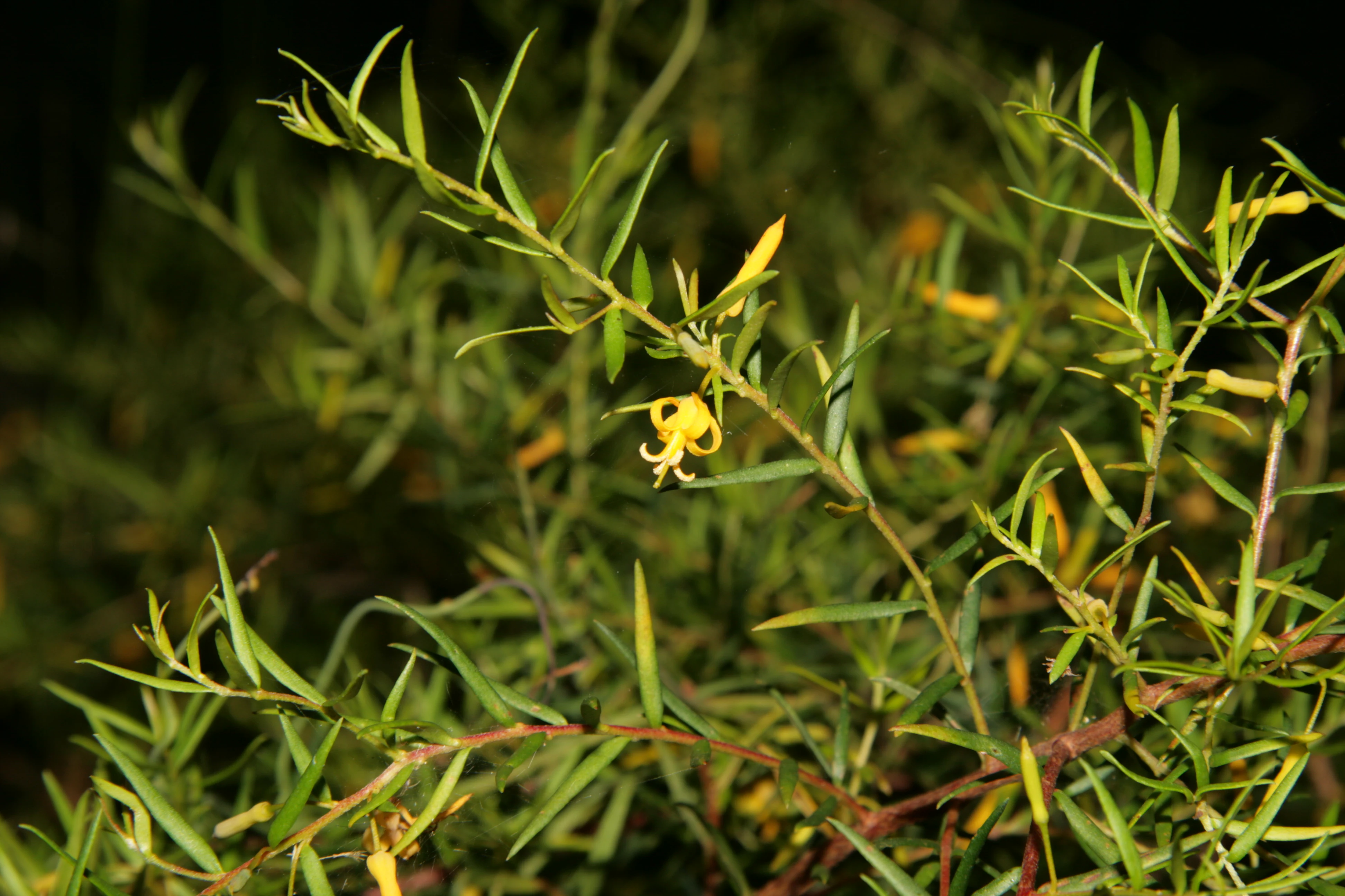
A close-up view of a Bargo Geebung shrub featuring narrow green leaves and a distinct yellow flower with curved petals.
A Bargo Geebung (Persoonia bargoensis) shrub in flower within Wirrimbirra Sanctuary.

Wirrimbirra Sanctuary history and protected-area timeline

The story of Wirrimbirra begins in the early 1960s, when Sydney accountant Carmen Coleman recognised the ecological and historical importance of a tract of remnant bush near Bargo. This was the same landscape in which European settlers at Bargo had made their first observations of the koala and the lyrebird, making the site foundational to the natural history of New South Wales. Coleman donated the land to the newly formed David G. Stead Memorial Wildlife Research Foundation, established in 1963 to honour David Stead's contributions to nature conservation in Australia.

The National Trust of Australia (NSW) became closely associated with the sanctuary from 1963 onward, and by 1965 it had received the freehold land, buildings, and improvements from the Stead Foundation, alongside arrangements for the transfer of associated Crown leases. The sanctuary expanded further in 1975, and in 1989 an additional narrow strip of land was purchased along the southern boundary to enhance fire protection for the Field Studies Centre, which had been opened in 1971.

The property's cultural and scientific importance has continued to grow. It was officially recognised with entry on the New South Wales State Heritage Register on 1 March 2002, and in late 2015 the National Trust classified the adjoining Bargo Gorge Landscape Conservation Area. A comprehensive Conservation Agreement with the New South Wales Office of Environment and Heritage now governs the long-term management of the sanctuary's native vegetation. A notable horticultural milestone came when a white waratah raised at the property had its varietal name, Wirrimbirra White, registered on the National Variety Register in Canberra.

Wirrimbirra Sanctuary landscape and geographic character

The sanctuary occupies about 95 hectares of relatively flat plateau country on the Bargo area, roughly halfway between the Bargo River crossing and the village of Bargo along the Hume Highway. Its defining landscape feature is a rare surviving example of the original Bargo Brush, a woodland community that once spread extensively south of Sydney before most of it was cleared for settlement and agriculture.

The terrain is gentle and accessible, shaped around formalised native gardens, walking paths, and outdoor classrooms that use the surrounding bush as a teaching landscape. The property links larger natural areas across the Sydney region, forming part of an ecological corridor between the metropolitan and Warragamba catchments and the Greater Blue Mountains. Within the sanctuary, the Bargo River gorge and its associated vegetation form an important backdrop, and the site also includes facilities such as ranger cottages, an office, a bookshop, and bunk-style accommodation for visiting school groups.

Wirrimbirra Sanctuary ecosystems, habitats, and plant life

The ecological heart of Wirrimbirra is its remnant Bargo Brush, a eucalyptus-dominated woodland that has all but vanished from the surrounding region. Because so much of the surrounding plateau has been cleared, the sanctuary functions as a refuge for plant and animal communities that would otherwise have no local foothold, and its vegetation includes rare and threatened species.

Beyond the natural bushland, Wirrimbirra has built up an exceptional cultivated collection of Australian native flora. Forty-three established gardens host more than 1,800 native plants, designed to represent a wide range of plant communities, from aquatic plants through understorey shrubs to mature tree canopies. These plantings give the sanctuary a layered, garden-meets-bushland character, where formal horticulture and wild vegetation sit side by side. The native plant nursery, registered under New South Wales horticultural legislation, supports both the internal gardens and wider propagation efforts, including the famous Wirrimbirra White waratah.

Wirrimbirra Sanctuary wildlife and species highlights

The sanctuary's bushland provides habitat for native fauna typical of the Sydney region sandstone and shale transitions, and it sits within a recognised wildlife corridor linking the metropolitan and Warragamba catchments with the Greater Blue Mountains. The property's biodiversity value is one of the reasons it was inscribed on the New South Wales State Heritage Register.

The site's place in Australian natural history is especially notable: this is the landscape where European settlers at Bargo made the first written observations of both the koala and the lyrebird. Today the sanctuary continues to support these species and other native wildlife, with the surrounding cleared land making the property's intact habitat all the more significant as a refuge.

Wirrimbirra Sanctuary conservation status and protection priorities

Wirrimbirra is recognised as one of the most important conservation sites in southwestern Sydney. Its protection status rests on several layers: ownership by the National Trust of Australia (NSW), heritage listing on the New South Wales State Heritage Register since 2002, a Conservation Agreement with the New South Wales Office of Environment and Heritage, and the 2015 classification of the adjoining Bargo Gorge Landscape Conservation Area.

The sanctuary matters because it preserves a rare piece of the Bargo Brush, a vegetation community that has been heavily depleted elsewhere, and because it maintains a functioning ecological link between the metropolitan and Warragamba catchments and the Greater Blue Mountains. Its environmental education program, recognised internationally including through a 1992 OECD specialist visit, has long amplified its conservation impact well beyond its 95 hectares, making Wirrimbirra both a literal refuge and a model for conservation practice in New South Wales.

Wirrimbirra Sanctuary cultural meaning and human context

The cultural identity of Wirrimbirra is closely tied to the European settlement of the Southern Highlands and broader New South Wales. The sanctuary's bushland was part of the landscape encountered by pioneering expeditions into the Southern Tablelands during the first half of the nineteenth century, and it was within this bush that the koala and lyrebird were first scientifically noted by settlers at Bargo.

The property also reflects mid-twentieth-century conservation culture in Australia. It was established in the early 1960s through the collaboration of individual donors, visionaries like David Stead, and the National Trust movement, embodying the period's growing commitment to nature conservation and environmental education. That legacy continues to shape the sanctuary's role as a community touchstone and a teaching landscape for new generations of Australian students.

Top sights and standout views in Wirrimbirra Sanctuary

The sanctuary's standout qualities include its rare remnant Bargo Brush, its network of more than forty native plant gardens housing thousands of indigenous species, and its internationally recognised Field Studies Centre.

Equally distinctive is the sanctuary's deep connection to the early natural history of New South Wales through the first recorded European sightings of the koala and lyrebird, and its status as both a wildlife corridor link and a heritage-listed conservation symbol owned by the National Trust of Australia (NSW).

Best time to visit Wirrimbirra Sanctuary

The sanctuary's mild southwestern Sydney climate makes it accessible year round, with cooler months from autumn through early spring offering the most comfortable conditions for walking the gardens and bushland trails. Spring is particularly rewarding for native wildflower displays, including waratahs and other species in bloom across the formal gardens, while the cool, clear days of winter make outdoor education programs easier to enjoy in the Field Studies Centre surroundings. Hot summer days can be warm on the open plateau, so early morning or late afternoon visits are often more pleasant during this season.

Monthly climate preview

Long-term monthly temperature and precipitation patterns across representative New South Wales coordinates

Wirrimbirra Sanctuary Climate Normals and Annual Temperature Rhythm

Representative coordinate records outline long-term monthly temperature and precipitation variations across the protected terrain of Wirrimbirra Sanctuary. Comprehensive monthly climate statistics provide deeper historical baseline context for analyzing annual thermal and moisture cycles.
Annual mean15 °C
9 °C21 °C
Jan21°
Feb21°
Mar19°
Apr16°
May13°
Jun10°
Jul
Aug10°
Sep13°
Oct15°
Nov18°
Dec20°
Warmest month
January

21.4 °C

Coolest month
July

9.2 °C

Wettest month
February

4.5 mm/day

Driest month
July

1.8 mm/day

Park location guide

Geography guide, regional context, and park location map for Wirrimbirra Sanctuary

Wirrimbirra Sanctuary park geography, regions, and map view in Australia

Understand where Wirrimbirra Sanctuary sits in Australia through a broader geographic reading of the surrounding landscape, nearby location context, and its mapped position within the national park landscape.

How Wirrimbirra Sanctuary fits into Australia

Australia is a constitutional monarchy and federal parliamentary democracy comprising six states and ten territories. With a population of nearly 28 million, it is one of the world's most urbanised countries, with most people concentrated on the eastern seaboard. The country has a high Human Development Index and is known for its cultural diversity, ancient Aboriginal heritage, and unique wildlife.

Wider geography shaping Wirrimbirra Sanctuary in Australia

Australia occupies the entire Australian continent, the island of Tasmania, and numerous smaller islands. It is the world's flattest and driest inhabited continent, featuring vast deserts in the interior (the Outback), tropical rainforests along the eastern coast, and a coastline bordering the Indian and Pacific Oceans.

Map view of Wirrimbirra Sanctuary

Use this park location map to pinpoint Wirrimbirra Sanctuary in Australia, understand its exact geographic position, and read its mapped placement within the surrounding landscape more clearly.

Pigeon | © OpenStreetMap contributors

Location context for Wirrimbirra Sanctuary

New South Wales

Visual reference of rare Bargo Brush habitats, native gardens, and terrain

Wirrimbirra Sanctuary Photos and Protected Woodland Landscape Views

Examine professional field imagery documenting the native flora, plateau terrain, and woodland ecosystems preserved across Wirrimbirra Sanctuary. Visual documentation clarifies the unique ecological composition of the surviving Bargo Brush and the surrounding regional wildlife corridor.

A close-up view of a Bargo Geebung shrub featuring narrow green leaves and a distinct yellow flower with curved petals.

Park atlas

Compare regional woodland reserves and connected conservation areas across New South Wales.

Exploring Parks Near Wirrimbirra Sanctuary and Surrounding Protected Landscapes

Visitors exploring Wirrimbirra Sanctuary can continue examining regional woodland reserves and connected conservation corridors across the surrounding New South Wales landscape. Expanding the geographic scope reveals how remnant protected areas link local wildlife habitats to broader metropolitan catchments.
National parkAustralia
About 4.1 km away#1 closest

Northwest

Thirlmere Lakes National Park: Explore Australia's National Park Geography

Mapped boundaries and protected landscape context.

Thirlmere Lakes National Park offers a focused view into Australia's network of protected natural areas. This atlas-oriented content details the park's specific geographic identity, its mapped boundaries, and its significance as a conserved landscape. Engage with the structured data to understand the terrain and regional context of this unique Australian national park.

Area
6.29 km²
Established
1972
IUCN
II
Climate
Temperate
National parkNew South Wales
About 5.8 km away#2 closest

West

Nattai National Park: Protected Landscape Within New South Wales Geography

Mapped boundaries and regional context for this national park.

Nattai National Park represents a distinct protected landscape within the broader geographic context of New South Wales, Australia. This entry focuses on its identity as a national park, detailing its mapped boundaries and its significance for structured geographic and atlas exploration. Users can uncover the specific park identity and its role within the regional mapped terrain.

Area
489.84 km²
Established
1991
IUCN
II
Visitors
1K annual
National parkNew South Wales
About 23 km away#3 closest

East

Dharawal National Park: Sandstone Landscapes and Upland Swamp Ecosystem Atlas

Discover mapped protected area boundaries and unique biodiversity.

Dharawal National Park, situated in New South Wales, is a significant protected area distinguished by its globally important upland swamp ecosystems, which exhibit the highest species richness of shrub and sedge communities found anywhere on Earth. This national park features a varied terrain, from steep gorges and waterfalls to sandstone woodlands and rainforest valleys, all contributing to its exceptional biodiversity and status as a crucial koala habitat within southern Sydney. Its landscape context on the Woronora Plateau provides a unique geographic perspective for understanding protected Australian natural areas.

Area
65.08 km²
Established
2012
IUCN
II
Relief
Mixed relief
State or regional parkNew South Wales
About 25 km away#4 closest

East

Illawarra Escarpment State Conservation Area: Mapped Geography and Protected Area Context

Regional protected landscape and sandstone escarpment in New South Wales

Examine the geographic structure and landscape composition of the Illawarra Escarpment State Conservation Area. This resource maps the 40-kilometre stretch of sandstone cliffs and forested foothills that rise above the Illawarra coastal plain, providing a detailed look at the six sections that constitute this unique state conservation land.

Area
27.72 km²
Established
1980
Relief
Mountain
Climate
Temperate
National parkNew South Wales
About 32 km away#5 closest

South

Macquarie Pass National Park: National Park Protected Landscape and Regional Geography

Mapped protected area boundaries and natural terrain context.

Macquarie Pass National Park is an important protected natural landscape situated in New South Wales. This page offers an atlas-focused view, detailing the park's precise geographic extent and its significance as a national park. Understanding its mapped boundaries and its position within the regional geography allows for a deeper appreciation of its protected status and the natural terrain it encompasses, serving as a key entry point for geographic discovery.

Area
11 km²
Established
1969
IUCN
II
Relief
Mountain
A soft, horizontal watercolor painting depicting a calm wetland area with grassy banks, still water reflecting soft colors, and distant rolling hills.
Nature reserveNew South Wales
About 34 km away#6 closest

Southwest

Cecil Hoskins Nature Reserve Protected Wetland Landscape in New South Wales Australia

Mapped riverine terrain and ecological sanctuary boundaries

This protected area centers on the Wingecarribee River, providing a rare refuge for waterbirds and remnant native bushland in the Southern Highlands. The reserve integrates dammed swampy floodplains with open grassy meadows and eucalypt stands, creating a compact yet ecologically significant site that demonstrates the importance of small-scale landscape restoration in New South Wales.

Area
0.46 km²
Established
1975
IUCN
IV
Relief
Lowland
National parkNew South Wales
About 34 km away#7 closest

Northeast

Georges River Koala National Park: A Protected Landscape for Critical Koala Habitat in New South Wales

Mapped geography and unique wildlife sanctuary.

Georges River Koala National Park represents a key protected area within New South Wales, specifically designated for safeguarding critical koala populations. This national park offers an invaluable insight into the region's undulating woodland terrain and the Georges River corridor's role in providing essential habitat. Understand the park's landscape character, its mapped boundaries, and its importance as a sanctuary for chlamydia-free koala colonies.

Area
18.3 km²
Established
2023
IUCN
II
Relief
Lowland
Nature reserveNew South Wales
About 37 km away#8 closest

South

Robertson Nature Reserve: Mapping a Rare Rainforest Remnant in the New South Wales Highlands

Protected warm temperate rainforest and escarpment geography

Robertson Nature Reserve serves as a vital conservation anchor in the New South Wales Southern Highlands. This reserve protects a dense fragment of warm temperate rainforest, characterized by its low canopy and rich basaltic soil composition. The area offers an opportunity to study the distinct ecology of the historic Yarrawa Brush and its adaptation to the high rainfall conditions along the Illawarra Escarpment.

Area
0.053 km²
Established
1979
Relief
Upland
Climate
Temperate

Common questions about visiting, size, designation, and location context for Wirrimbirra Sanctuary

Wirrimbirra Sanctuary FAQs for park facts, access, geography, and protected area context

Find quick answers about Wirrimbirra Sanctuary, including protected-area facts, park geography, trail and visitor context, and how the park fits into its surrounding country and regional landscape.
MoriAtlas Explorer

Continue Your Protected Areas Search Across the Global Atlas

Deepen your exploration by continuing the structured search for national parks and protected areas worldwide. Utilize the comprehensive filtering capabilities to compare different conservation landscapes and refine your understanding of global park geography. Discover more about the distribution and characteristics of protected natural areas.

Global natural geography