
Mori Atlas logo
Nature reserveWollingster See und Randmoore

Tracing the mapped boundaries of an ecologically vital mire and lake mosaic in Lower Saxony

Wollingster See und Randmoore Nature Reserve: An Atlas of Glacial Lakes and Raised-Bog Landscapes

(Naturschutzgebiet Wollingster See und Randmoore)

Wollingster See und Randmoore stands as a significant protected nature reserve in Lower Saxony, defined by the juxtaposition of a deep, oligotrophic glacial lake and extensive, re-wetted raised-bog fringes. This detailed atlas entry maps the complex mosaic of open water, moor heath, and birch-pine bog woodland, illustrating how centuries of landscape evolution and modern conservation efforts shape this unique Elbe-Weser site.

nature reserveLower SaxonyBeverstedtCuxhaven districtglacial lakeoligotrophic lake
A flat-style digital illustration of a lake landscape at sunset, featuring lush foreground vegetation, a central lake, distant forests, and a small waterfall flowing off a cliffside under a pastel sky.

Wollingster See und Randmoore

Nature reserve

Park overview

Structured park overview, official facts, and landscape profile for Wollingster See und Randmoore

Wollingster See und Randmoore park facts, protected area profile, and essential visitor context

Review the core facts for Wollingster See und Randmoore, including designation, size, terrain, visitor scale, habitats, and operating context in one park-focused overview.

About Wollingster See und Randmoore

Wollingster See und Randmoore represents a typical, and ecologically valuable, combination of a glacial lake and surrounding bog landscape in northwestern Germany. It lies northeast of the community of Beverstedt, north of Bremerhaven, and forms part of a network of nature reserves in the district of Cuxhaven that protect fragments of the historic Geest and moor landscape between the Weser and Elbe estuaries.

The Wollingster See is a small but unusually deep lake of about 4.5 hectares, roughly 300 metres long and 180 metres wide, reaching around 14.5 metres at its deepest point. Its water quality is oligotrophic, meaning it is very low in nutrients, a condition that supports a set of sensitive aquatic species that have become rare across much of lowland Germany. These include shoreweed (Strandling) and water lobelia (Wasser-Lobelie), with quillwort (Brachsenkraut) having been recorded here into the early twenty-first century, though it is now difficult to find.

The lake is bordered on its southern side by the Beverstedter Moor and parts of the Osterndorfer Moor. These are raised-bog (Hochmoor) areas that have been substantially altered by drainage and historical peat-cutting (Torfstiche). Today most of these mires carry birch-pine bog woodland (Birken-Kiefern-Moorwälder), while open areas retain pockets of raised-bog vegetation, moor heath, and floating bog mats. Restoration efforts aim to rewet the peat surfaces.

The reserve sits almost entirely within the 1973-designated landscape protection area (Landschaftsschutzgebiet) Osterndorfer Moor, which extends several times larger than the nature reserve itself. Around the protected core, agricultural land and pasture dominate, with Moorschnucken heath sheep used to keep the marginal heath areas open. A short, waymarked walking path of about 1.5 kilometres circles the lake, and a campsite lies just north of it on the reserve's edge.

Quick facts and research context for Wollingster See und Randmoore

Wollingster See und Randmoore is a nature reserve of around 117 hectares in the district of Cuxhaven, Lower Saxony. It is administered by the Landkreis Cuxhaven under the code NSG CUX-001 and is largely part of the FFH site "Wollingster See mit Randmooren". Earlier protection of the lake itself dates back to 1932, while a separate Wollingster See reserve (NSG LÜ 012) from 1962 was later merged into the current area. The lake is small but unusually deep for its size, has oligotrophic water quality, and is ringed by raised-bog fringe habitats that are targeted for rewetting and heath conservation.

Protection and recognition

Explore documented terrestrial conservation scope and official designation records.

Wollingster See und Randmoore Protection Status and Designated History

Wollingster See und Randmoore maintains a recorded terrestrial protection status established in two thousand and ten. Official records outline the formal designation history and management scope without additional international recognition sources.

Protection details

Protection scope
Terrestrial
Designated year
2010
Transboundary protection
No
WDPA ID
82942
Park context

Deeper park guide and search-rich context for Wollingster See und Randmoore

Wollingster See und Randmoore history, landscape, wildlife, and travel context

Explore Wollingster See und Randmoore through its history, landscape character, ecosystems, wildlife, conservation priorities, cultural context, and seasonal travel timing in a structured park guide built for atlas discovery and search intent.

Why Wollingster See und Randmoore stands out

The reserve is best known for pairing a clear, nutrient-poor glacial lake with extensive raised-bog fringe habitats in a relatively compact protected area. The Wollingster See is noted for its oligotrophic water quality and its aquatic flora, including shoreweed (Strandling), water lobelia, and historically quillwort (Brachsenkraut), as well as reed, bulrush, and dwarf-shrub heath communities along the shore. Just as importantly, the surrounding Beverstedter Moor and parts of the Osterndorfer Moor give the site its defining character: drained, peat-cut mire lands now largely wooded with birch and pine, with remaining patches of raised-bog vegetation, moor heath, and quaking bog (Schwingrasen) that are the focus of restoration through rewetting (Wiedervernässung) and traditional grazing with Moorschnucken heath sheep.
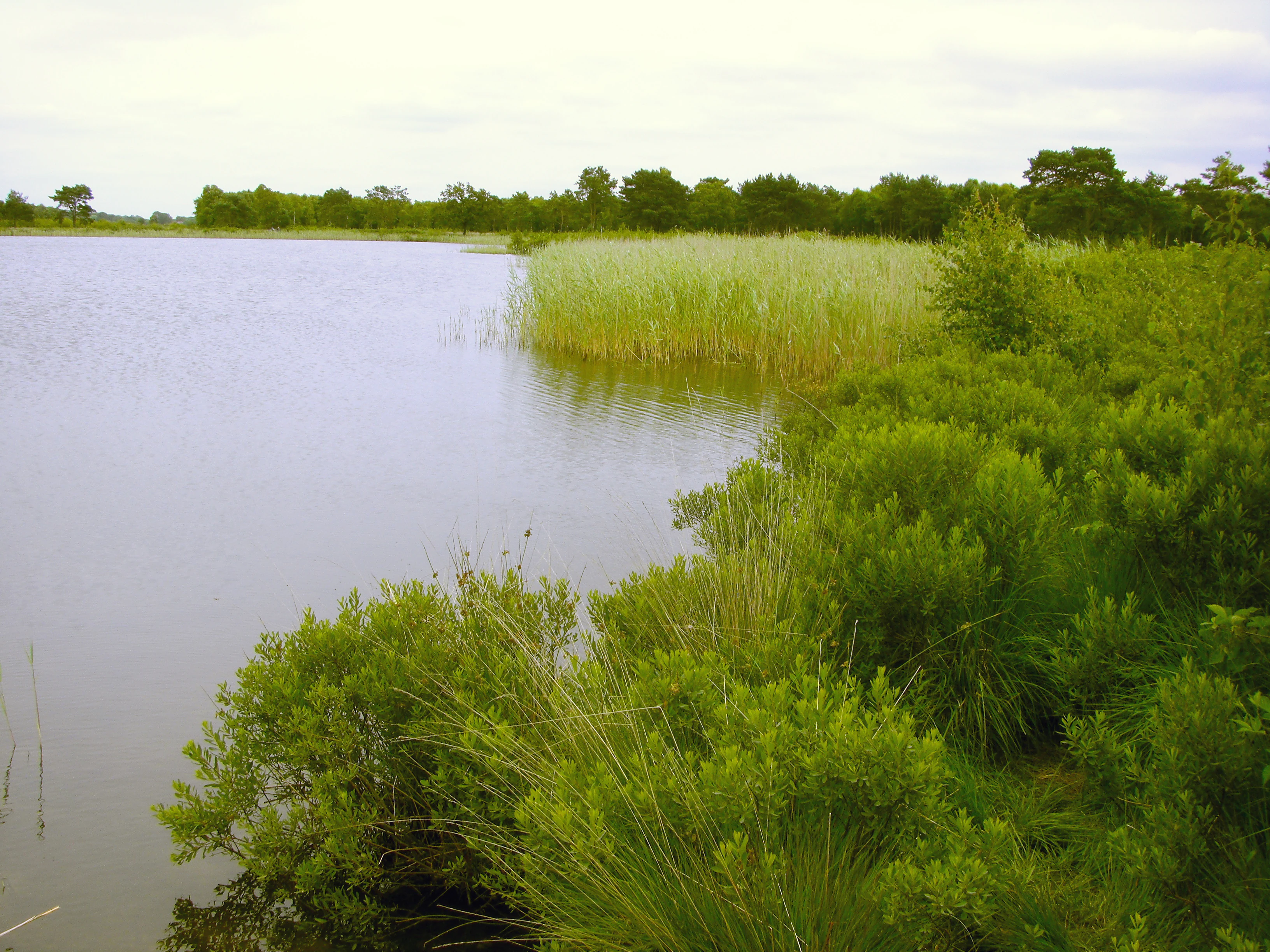
A wide landscape shot of a calm, grey-toned lake with green marshy grasses and shrubs along the shoreline.
A view of the Wollingster See nature reserve, showcasing the lake and surrounding wetland vegetation.

Wollingster See und Randmoore history and protected-area timeline

The lake Wollingster See has a long history of formal protection. It was first placed under nature conservation in 1932, making it one of the older small-lake reserves in Lower Saxony.

In March 1962, a separate 9-hectare nature reserve called "Wollingster See" (NSG LÜ 012) was established to reinforce protection of the lake itself. Until 2010, this smaller lake-only reserve functioned as the principal formal designation for the site.

On 17 September 2010, the larger Wollingster See und Randmoore nature reserve (NSG CUX-001) came into effect: it absorbed the earlier Wollingster See reserve and extended protection to the adjoining bog areas of Beverstedter Moor and parts of Osterndorfer Moor, bringing the total protected area to roughly 117 hectares.

The Osterndorfer Moor, surrounding the reserve, had already received landscape-level protection in 1973 under a roughly 900-hectare Landschaftsschutzgebiet. The reserve now sits almost entirely within that protective buffer.

Today the area is managed with attention to two intertwined goals: maintaining the lake's oligotrophic character and rewetting the drained bog fringe to restore raised-bog vegetation, while traditional grazing continues to keep the marginal heath open.

Wollingster See und Randmoore landscape and geographic character

The landscape of Wollingster See und Randmoore is defined by a clear contrast between a single, compact body of open water and the broad, flat expanse of bog that wraps around and lies south of it. The lake sits in a Geest landscape shaped during the Saalian or Weichselian cold stages, and its basin was likely formed by a pingo whose ice core later melted and filled the resulting depression with water. Earlier interpretations suggested a glacial pothole (Strudelkolk).

The lake itself is small, only about 4.5 hectares, but relatively deep at up to 14.5 metres, with a narrow shore fringed by reeds, bulrushes, and short stretches of dwarf-shrub heath on sandy soil. To the south, the terrain transitions into the Beverstedter Moor and parts of the Osterndorfer Moor, where open raised bog, moor heath, and quaking bog (Schwingrasen) are interspersed with birch-pine bog woodland.

Drainage and historical peat cutting have left the bog surface largely wooded, with peat cuttings (Torfstiche) visible throughout. Rewetting is intended to restore raised-bog conditions. The reserve drains via the Dohrener Bach, a tributary of the Lune, and via the Frelsdorfer Mühlenbach, a tributary of the Geeste, and is otherwise surrounded by agricultural land. A short 1.5-kilometre waymarked path circles the lake, and the planned A 20 coastal motorway route passes within a few hundred metres to the north.

Wollingster See und Randmoore ecosystems, habitats, and plant life

Ecologically, the reserve is significant because it combines nutrient-poor aquatic habitats with raised-bog and bog-fringe habitats in very close proximity. The Wollingster See is oligotrophic, with clear, low-nutrient water that supports a specialised aquatic flora including shoreweed (Strandling) and water lobelia (Wasser-Lobelie), and historically quillwort (Brachsenkraut). These species are characteristic of clean, undisturbed northern European lakes and have become rare elsewhere in lowland Germany due to eutrophication.

Around the lake, the shore vegetation grades from bulrush and common reed (Schilfröhricht) into drier sandy areas where dwarf-shrub heath (Zwergstrauchheide) communities develop. On the bog side, the habitat mosaic includes raised-bog vegetation (Hochmoorvegetation), moor heath (Moorheide), and quaking bog mats (Schwingrasen), alongside birch-pine bog woodland on the more wooded, formerly drained sections of peat.

The reserve is also an important insect habitat: the lake supports mayflies, chironomids, and dragonflies, while the sandy margins around the shore host sand bees (Sandbienen), parasitoid wasps (Schlupfwespen), and ground beetles including the sand running beetle (Sandlaufkäfer). Together with its bog flora and fauna, the site is largely part of the Habitats Directive site "Wollingster See mit Randmooren".

Wollingster See und Randmoore wildlife and species highlights

The Wollingster See und Randmoore reserve supports a distinctive mix of bog, lake-edge, and sandy-habitat species. Among birds, the common crane (Kranich) and the short-eared owl (Sumpfohreule) are associated with the open bog areas, while reptiles include the adder (Kreuzotter), smooth snake (Schlingnatter), grass snake (Ringelnatter), and common lizard (Waldechse). The moor frog (Moorfrosch) is a characteristic amphibian of the bog fringe.

The lake is a key habitat for aquatic invertebrates, including mayflies (Eintagsfliegen), chironomid midges (Zuckmücken), and dragonflies (Libellen). The sandy areas around the lake support a different but equally rich invertebrate fauna, including sand bees, parasitoid wasps, and various beetles such as the sand running beetle (Sandlaufkäfer).

On the open sections of the surrounding moor, traditional grazing by Moorschnucken heath sheep helps maintain the open character of the heath, indirectly supporting the bird and reptile species that depend on these exposed bog and heath surfaces.

Wollingster See und Randmoore conservation status and protection priorities

Conservation significance at Wollingster See und Randmoore operates on two interconnected levels. The lake itself is protected as a representative of an increasingly rare type of habitat in lowland Germany: a small, deep, oligotrophic lake with intact aquatic plant communities including shoreweed, water lobelia, and historically quillwort. Such lakes are vulnerable to nutrient enrichment, sediment input, and shoreline disturbance, which is why both the earlier 1932 protection order and the later 1962 independent reserve were aimed at safeguarding the lake's water quality and shoreline vegetation.

The bog fringe is the second conservation focus. The Beverstedter Moor and parts of the Osterndorfer Moor have a long history of drainage and peat cutting, and current management aims to rewet (Wiedervernässung) the peat surfaces to restore raised-bog vegetation, including Hochmoorvegetation, Moorheide, and Schwingrasen. Where the moor remains wooded with birch and pine, restoration seeks to shift the balance back toward open bog habitats.

At the broader policy level, almost the entire reserve falls inside the FFH (Habitats Directive) site "Wollingster See mit Randmooren", granting it European-level recognition. It also lies almost entirely within the 1973-designated 900-hectare landscape protection area Osterndorfer Moor, which provides a substantial buffer of landscape-level protection. The wider area, however, faces pressure from the planned route of the A 20 coastal motorway, which passes only a few hundred metres north of the reserve.

Wollingster See und Randmoore cultural meaning and human context

The cultural dimension of Wollingster See und Randmoore is closely tied to the traditional rural landscape of the Elbe-Weser region. The surrounding Beverstedter Moor and Osterndorfer Moor were historically used for peat cutting (Torfstiche), a practice that fundamentally shaped today's landscape pattern of cuttings, bog woodland, and surviving open bog areas.

The heath fringes of the reserve are still managed with Moorschnucken, a hardy local heath-sheep breed whose grazing is integral to keeping the landscape open and to maintaining the cultural character of the area, alongside more recent rewetting-based nature management. The historical literature includes a 2004 essay in Niederdeutsches Heimatblatt connecting the lake with the early German Wandervogel hiking movement, reflecting how the site has long been part of regional walking and nature-experience traditions.

The reserve today sits in a working agricultural landscape, almost entirely surrounded by farmland, and the village of Beverstedt and the city of Bremerhaven anchor it within the broader settlement pattern of northern Lower Saxony.

Top sights and standout views in Wollingster See und Randmoore

Wollingster See und Randmoore is notable for the unusually close juxtaposition of a small, deep, oligotrophic lake with intact aquatic plant communities and an extensive raised-bog fringe still bearing the imprint of centuries of peat cutting and recent rewetting efforts. The shoreline vegetation runs through reeds into sandy dwarf-shrub heath, and the bog supports birch-pine bog woodland, open raised bog, moor heath, and quaking bog in a tight mosaic.

The site has unusually long continuity of formal protection, dating from 1932, and its lake reserve has been successively upgraded and merged into the present-day 117-hectare reserve. Almost the entire area is embedded in a broader European Habitats Directive designation and in a 900-hectare landscape protection area, while traditional Moorschnucken grazing and rewetting projects at its core make it a textbook example of integrated mire-and-lake conservation in the Elbe-Weser region.

Best time to visit Wollingster See und Randmoore

Spring and early summer are generally the most rewarding time to experience Wollingster See und Randmoore, when water-lobelia and shoreweed characterise the lake vegetation and bog-fringe invertebrates and dragonflies are most active. Early morning visits in this period also increase the chances of seeing bog-associated birds such as the common crane.

Late summer and autumn tend to bring calmer lake surfaces and a different visual quality to the moor edge, with the birch-pine bog woodland and exposed heath areas at their most visually distinct. Winters in the region can be cold and grey, but the open lake and bog scenery still have their own stark appeal. As with any visit to a small German nature reserve, low-noise, low-impact behaviour and staying on the marked 1.5-kilometre circular path are the best way to enjoy the reserve without disturbing its protected habitats.

Monthly climate preview

Long-term representative point measurements for temperature and precipitation rhythms

Wollingster See und Randmoore Climate Normals and Annual Weather Patterns

Representative coordinate records show measured monthly temperature variations alongside persistent precipitation averages throughout the year. Reviewing these long-term climate normals provides essential baseline context for the protected area.
Annual mean9 °C
1 °C18 °C
Jan
Feb
Mar
Apr
May12°
Jun16°
Jul18°
Aug18°
Sep14°
Oct10°
Nov
Dec
Warmest month
July

17.9 °C

Coolest month
January

1.2 °C

Wettest month
July

2.6 mm/day

Driest month
April

1.4 mm/day

Park location guide

Geography guide, regional context, and park location map for Wollingster See und Randmoore

Wollingster See und Randmoore park geography, regions, and map view in Germany

Understand where Wollingster See und Randmoore sits in Germany through a broader geographic reading of the surrounding landscape, nearby location context, and its mapped position within the national park landscape.

How Wollingster See und Randmoore fits into Germany

Germany is a federal republic in Western and Central Europe with a population of over 83 million across sixteen constituent states. It is Europe's largest economy by nominal GDP and a major global exporter and importer. The capital is Berlin, and the country borders Denmark, Poland, Czech Republic, Austria, Switzerland, France, Luxembourg, Belgium, and the Netherlands.

Wider geography shaping Wollingster See und Randmoore in Germany

Germany is located in Western and Central Europe, spanning 357,022 km². It borders Denmark to the north, Poland and the Czech Republic to the east, Austria and Switzerland to the south, and France, Luxembourg, Belgium, and the Netherlands to the west. The country has coastlines on the Baltic Sea and North Sea to the north, with the Alps located in the southern region.

Map view of Wollingster See und Randmoore

Use this park location map to pinpoint Wollingster See und Randmoore in Germany, understand its exact geographic position, and read its mapped placement within the surrounding landscape more clearly.

Pigeon | © OpenStreetMap contributors

Location context for Wollingster See und Randmoore

Lower Saxony

Explore detailed imagery of the glacial lake, raised bogs, and surrounding mire habitats.

Wollingster See und Randmoore Photos and Scenery: Visualizing the Protected Landscape

Visual documentation captures the stark contrast between the clear oligotrophic waters of the central lake and the expansive raised-bog fringe of the surrounding nature reserve. Examining these landscape photographs and habitat views reveals the complex terrain of birch-pine bog woodland, rewetting zones, and heath-grazed mire lands.

A wide landscape shot of a calm, grey-toned lake with green marshy grasses and shrubs along the shoreline.

Park atlas

Compare adjacent wetland reserves and regional bog landscapes across the Elbe-Weser district.

Other Parks Near Wollingster See und Randmoore and Surrounding Protected Areas

Browse nearby protected areas and related wetland reserves that share similar post-glacial terrain and mire conservation features. Expanding the geographic comparison highlights how surrounding regional ecosystems connect back to the central lake habitat.
Nature reserveLower Saxony
About 12 km away#1 closest

North

Windbrackenholz Nature Reserve: A Detailed Look at Lower Saxony Woodland Geography

Protected oak-beech habitat in the Cuxhaven district.

Windbrackenholz represents a key example of long-standing forest conservation in the Lower Saxony lowlands. This nature reserve provides a critical window into the structure of Geest woodland habitats, characterized by its mature oak and beech trees and its integration into the wider regional forest mosaic. Delve into the protected boundaries and landscape context of this significant northwestern German site.

Area
0.34 km²
Established
1985
IUCN
IV
A soft watercolor painting featuring a reflective water surface, grassy marshland in the foreground, a tree line in the midground, and rolling, misty hills in the background.
Nature reserveBremen
About 17 km away#2 closest

Northwest

Düllhamm Nature Reserve: Protected Lowland Mosaic in Bremerhaven

Mapping the transitional forest and marshland terrain of Bremen.

Covering a small footprint, Düllhamm remains a vital nature reserve representing the lowland ecosystems of northern Germany. The area maps a unique gradient of dry oak-birch woodland shifting into wet meadows, boggy heath, and reed-covered marshes. This protected landscape offers a concentrated look at regional ecological patterns within the urbanized landscape of the Bremerhaven district.

Area
0.043 km²
Established
1984
Relief
Lowland
Climate
Temperate
Nature reserveLandkreis Cuxhaven
About 21 km away#3 closest

West

Teichfledermausgewässer Nature Reserve: Mapped Geography of the Lower Weser Lowland Waters

Protected riverine habitats and lowland water mosaic in Germany

Teichfledermausgewässer functions as a vital nature reserve within the Landkreis Cuxhaven region. This protected landscape encompasses a rich mosaic of oxbow stretches, lowland rivers, and former clay extraction pits that support rare wildlife. Through its integrated water bodies, the reserve forms a continuous conservation corridor that preserves the ecological integrity of the Lower Weser estuary and its unique floodplain ecosystems.

Area
6.33 km²
Established
2018
Nature reserveLower Saxony
About 21 km away#4 closest

Southwest

Südliches Hagener Königsmoor Nature Reserve: A Protected Peatland in Lower Saxony

Ecological mosaic of bog woodland and historical peat cuttings

Südliches Hagener Königsmoor is a protected nature reserve in Hagen im Bremischen, Lower Saxony. The terrain features a distinct mosaic of raised bog vegetation, drainage channels, and water-filled peat cuttings that anchor a rare remnant of the original lowland moor landscape against modern agricultural surroundings.

Area
0.85 km²
Established
1981
IUCN
IV
A soft, light-toned watercolor painting of a wetland landscape featuring green fields, a small path, a line of trees, and a distant low hill.
Nature reserveBremen
About 21 km away#5 closest

West

Luneplate Nature Reserve: A Detailed Geographic Atlas of Bremen's Coastal Wetland Landscapes

Protected estuarine habitats and tidal geography in the Weser river basin

Luneplate Nature Reserve offers a rich study of coastal wetland geography. Spanning the interface between the Weser river and the North Sea, the reserve features extensive mudflats, saltmarshes, and reedbeds. This protected landscape serves as an essential migratory hub, providing habitat for diverse waterbird populations within the maritime environment of Bremerhaven.

Area
14.38 km²
Established
2015
IUCN
IV
Nature reserveLower Saxony
About 21 km away#6 closest

Southeast

Swatte Flag Nature Reserve in Lower Saxony: Protected Landscape and Geographic Overview

An important refuge for heathland and bog-margin habitats.

Swatte Flag is a protected nature reserve in Lower Saxony, known for its two shallow Schlatt ponds and surrounding heathland mosaic. Established to manage rare habitat types within a reclaimed moorland landscape, the reserve features a sharp ecological contrast between its nutrient-poor grassland, wet bog pockets, and the adjacent intensive farmland.

Area
0.164 km²
Established
1965
IUCN
IV
Relief
Lowland
Watercolor painting showing coastal wetlands with mudflats, salt marshes, and distant hills under a soft light
National parkLower Saxony
About 23 km away#7 closest

West

Lower Saxon Wadden Sea National Park: Protected Coastal Landscape & Geography Atlas

Explore mapped boundaries, intertidal zones, and Lower Saxony's natural terrain.

Delve into the Lower Saxon Wadden Sea National Park, a significant national park situated in Lower Saxony, Germany. This page serves as your atlas entry point for understanding its protected landscape, characterized by vast mudflats, salt marshes, and a crucial role as a migratory bird corridor. Discover the geographic context of this UNESCO World Heritage site and its unique intertidal ecosystem through structured map data and detailed landscape information.

Area
345.8 km²
Established
1986
IUCN
II
Relief
Lowland
Nature reserveLandkreis Cuxhaven
About 25 km away#8 closest

North

Wildes Moor bei Stinstedt: Protected Raised Bog and Wetland Geography in Lower Saxony

Examining Moorland Habitat and Terrain within Landkreis Cuxhaven

Wildes Moor bei Stinstedt serves as a crucial example of a small scale raised bog landscape surviving within a modified agricultural plain. This overview outlines the protected area's history of peat extraction and drainage, offering a detailed perspective on the site's ongoing role as a managed habitat for specialized bog vegetation in the North German coastal region.

Area
0.57 km²
Established
1984
IUCN
IV
Relief
Lowland

Common questions about visiting, size, designation, and location context for Wollingster See und Randmoore

Wollingster See und Randmoore FAQs for park facts, access, geography, and protected area context

Find quick answers about Wollingster See und Randmoore, including protected-area facts, park geography, trail and visitor context, and how the park fits into its surrounding country and regional landscape.
MoriAtlas Explorer

Continue Your Protected Areas Search Across the Global Atlas

Deepen your exploration by continuing the structured search for national parks and protected areas worldwide. Utilize the comprehensive filtering capabilities to compare different conservation landscapes and refine your understanding of global park geography. Discover more about the distribution and characteristics of protected natural areas.

Global natural geography