Mori Atlas logo
Nature reserveWormser Ried

A vital remnant of floodplain habitat framed within the industrial periphery of Worms

Wormser Ried Nature Reserve: Exploring the Wetland Geography and Protected Landscape Mosaic

(Naturschutzgebiet Wormser Ried)

The Wormser Ried encompasses a unique, embanked wetland system located within the Upper Rhine plain. This protected nature reserve, situated on the southern outskirts of Worms, features a complex mosaic of former industrial settling basins, reed beds, alluvial woodland, and damp meadows. As an essential refuge for amphibians and waterbirds, the area provides a critical case study in how small, enclosed habitats function within the broader Rhine floodplain network.

nature reservewetland habitatformer settling pondsreedbedssoftwood floodplain forestalluvial woodland

Wormser Ried

Nature reserve

Park overview

Structured park overview, official facts, and landscape profile for Wormser Ried

Wormser Ried park facts, protected area profile, and essential visitor context

Review the core facts for Wormser Ried, including designation, size, terrain, visitor scale, habitats, and operating context in one park-focused overview.

About Wormser Ried

The Wormser Ried is a small but ecologically meaningful nature reserve on the southern edge of Worms, near where the city meets the broader Rhine floodplain. Covering about 35 hectares, it has been legally protected since 1968 and forms a self-contained patch of wetland habitat within a heavily developed part of Rhineland-Palatinate. Although national parks and large wilderness areas typically draw the most attention, reserves like the Wormser Ried highlight how even compact urban-edge sites can carry real ecological weight.

The reserve's character is closely tied to its industrial past. Its core waterbodies originated as settling basins for the Worms leather industry, and after that industrial function ended, the basins were allowed to evolve naturally. Over decades, these artificial ponds filled in around their edges, producing reed beds, transitional marsh zones, softwood alluvial forest remnants, and damp meadows. The reserve is therefore a secondary habitat, a place where ecological value has emerged from an engineered landscape rather than from untouched natural terrain.

Geographically, the Wormser Ried sits within the Bürgerweide area, in the southwest of the larger Worms floodplain zone. It is bounded on the northwest by the Worms airfield, to the northeast by the elevated Bundesstraße 9, and to the south by the Eckbach, a small stream running between two embankments that marks the boundary between the city of Worms and the Rhein-Pfalz-Kreis. Because the reserve lies between several embankments, it is largely isolated from natural river flooding, and management interventions have repeatedly been needed to keep the ponds and reed habitats in good condition.

The site is formally nested within a wider network of protected landscape. It lies inside the Rheinhessisches Rheingebiet landscape protection area and is part of the European FFH area Rheinniederung Ludwigshafen-Worms, which links it into broader conservation planning along the Upper Rhine floodplain. Together with neighboring reserves such as the Eich-Gimbsheimer Altrhein, the Wormser Ried contributes to the regional picture of how the Rhine floodplain between Ludwigshafen and Worms has been protected in sections rather than as one continuous wilderness.

Quick facts and research context for Wormser Ried

The Wormser Ried is a nature reserve (Naturschutzgebiet) in southern Worms, Rhineland-Palatinate, covering roughly 35 hectares. Its habitats originate from former settling ponds of the Worms leather industry, making it a secondary habitat rather than a naturally formed wetland.

It was formally placed under protection on 20 September 1968 by the Bezirksregierung Rheinhessen. The site is also included within the larger European FFH (Fauna-Flora-Habitat) area known as Rheinniederung Ludwigshafen-Worms and forms part of the Rheinhessisches Rheingebiet landscape protection area. Its reserved wet habitats serve both biotope protection and the protection of breeding and migratory waterbirds, amphibians, and reptiles.

Protection and recognition

Documented terrestrial conservation status and official establishment timeline for Wormser Ried

Wormser Ried Protection Status and Designated Area History

Wormser Ried maintains a documented terrestrial protection status established in 1968 across its designated regional landscape. Structured records outline the formal conservation timeline, management scope, and recognition history for this protected natural area.

Protection details

Protection scope
Terrestrial
Designated year
1968
Transboundary protection
No
Park context

Deeper park guide and search-rich context for Wormser Ried

Wormser Ried history, landscape, wildlife, and travel context

Explore Wormser Ried through its history, landscape character, ecosystems, wildlife, conservation priorities, cultural context, and seasonal travel timing in a structured park guide built for atlas discovery and search intent.

Why Wormser Ried stands out

The Wormser Ried is best known as a compact, embanked wetland reserve nested inside the urban and industrial periphery of Worms. Its identity is defined not by natural river dynamics but by a closed-system mosaic of former settling ponds, reed belts, softwood alluvial forest fragments, and wet meadows. It is also recognized for its role in amphibian and bird conservation within the Rhine floodplain between Ludwigshafen and Worms. Because the area is largely sealed off from natural flooding, it requires active management to maintain water levels and habitat quality, and it stands out as an example of how an old industrial site has been converted into a functional protected habitat.
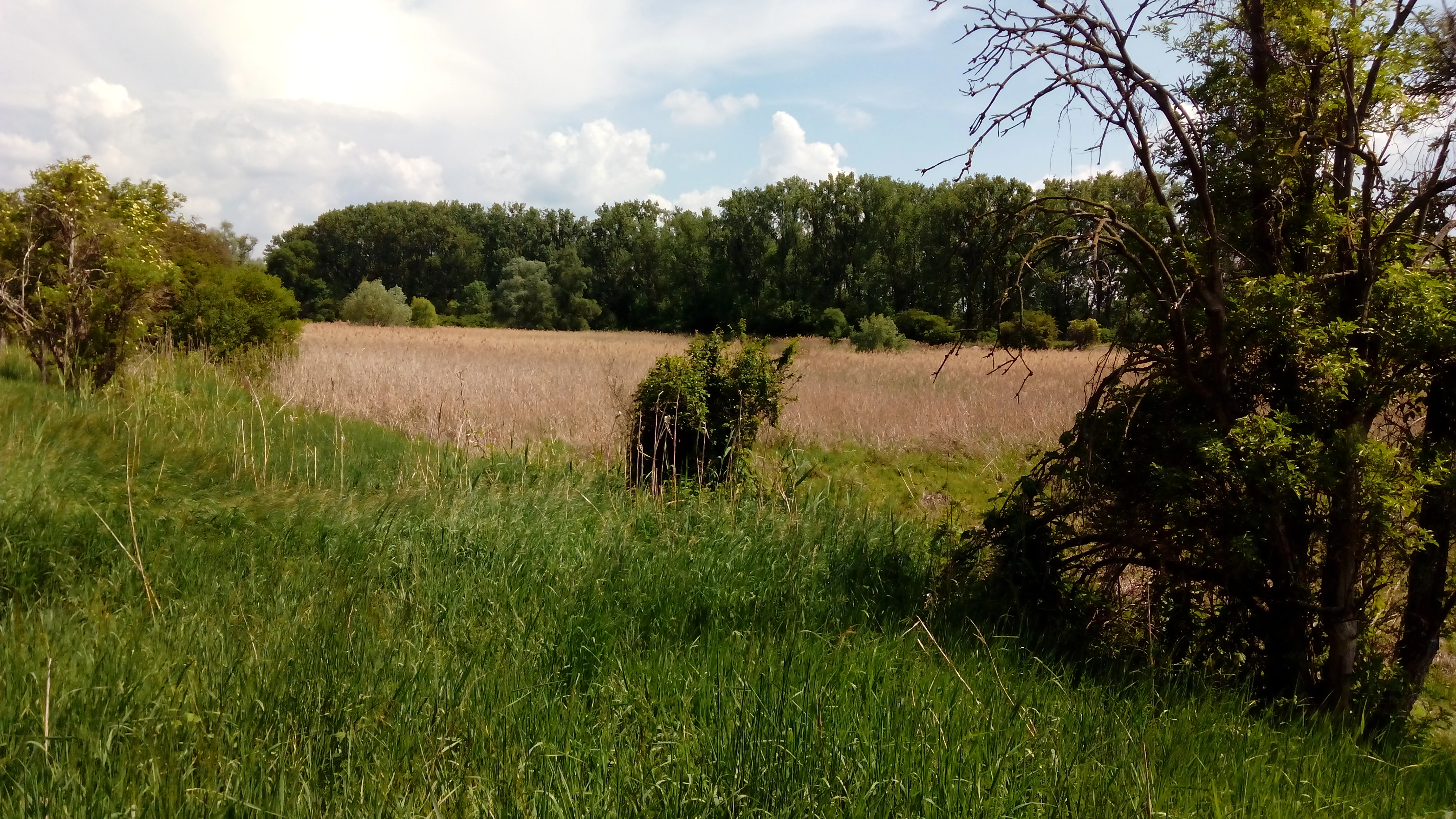
A landscape photograph showing a field of tall brown reeds in the middle ground, surrounded by green grass and bushes in the foreground, with a line of trees in the background under a partly cloudy sky.
View of the Wormser Ried nature reserve showing a central field of tall reeds bordered by green vegetation and a tree line.

Wormser Ried history and protected-area timeline

The Wormser Ried took on its current ecological form only after its earlier industrial function came to an end. For many years, its central waterbodies served as settling basins for wastewater from the Worms leather industry, discharging into structured ponds that separated solids and clarified effluent. Once this industrial use ended, the ponds were left to fill in and develop on their own, gradually becoming overgrown with reed belts and surrounded by alluvial woodland and damp meadows.

Formal recognition of the site's new ecological value came on 20 September 1968, when the Bezirksregierung Rheinhessen issued the legal ordinance placing the Wormser Ried under nature reserve (Naturschutzgebiet) protection. The protection order was framed around biotope conservation and the protection of birds and amphibians, recognizing that the closed, low-energy system provided unusually important refuge habitat within the developed Rhine floodplain.

Because the reserve sits between embankments and is largely cut off from natural inflows, the protection authority has had to carry out restoration and maintenance work multiple times since protection was granted. These interventions have aimed at keeping the settling basins open, maintaining water levels, and ensuring the special habitat mix of reeds, wet meadows, and softwood floodplain forest continues to support the species for which the reserve was originally designated. The site's conservation history is therefore not just about a one-time legal designation, but about ongoing management of a fragile, enclosed wetland.

Wormser Ried landscape and geographic character

The Wormser Ried sits on the floor of the Upper Rhine plain, in the southern periphery of Worms. Its relief is extremely flat, shaped by the broad, low-lying glacial and alluvial landscape typical of the Rhine rift valley. There are no cliffs, mountains, or dramatic terrain features; instead, the area has the quiet, water-shaped character of a floodplain mosaic, with shallow ponds, reed-lined margins, waterlogged meadows, and patches of low alluvial woodland.

The defining physical features of the reserve are the embankments that surround it. To the northwest lies the Worms airfield, to the northeast the elevated corridor of the Bundesstraße 9, and to the south the Eckbach, a small watercourse that runs between two embankments and forms the administrative boundary between the city of Worms and the Rhein-Pfalz-Kreis. Because the reserve lies within this embanked frame, natural flood pulses from the Rhine no longer reach it freely, and the area functions as an internally controlled wetland system rather than as an open section of the Rhine floodplain.

Within these boundaries, the landscape reads as a layered wetland mosaic. The cores of the old settling ponds remain as open water, fringed by reed beds and tall herb vegetation. Around the ponds, transitional marsh and damp meadow communities have colonized former pond edges, while the slightly higher ground is occupied by softwood alluvial forest fragments dominated by willows. This combination of open water, reeds, forest patches, and meadows gives the reserve its distinctive texture, even though it occupies only a few dozen hectares.

Wormser Ried ecosystems, habitats, and plant life

The ecological character of the Wormser Ried is defined by a relatively small, enclosed wetland system in which three main plant communities dominate. According to biotope surveys from 2007, the reserve is primarily composed of reed canary grass stands (Phalaridetum arundinaceae), common reed communities (Phragmition australis), and white willow softwood floodplain forest (Salicion albae), with smaller patches of other plant associations filling in the margins and transitions.

Because of this habitat mix, the reserve supports ecological functions typical of larger floodplain wetlands, even at a compact scale. The open water and reed zones provide key habitat for waterbirds, amphibians, and aquatic invertebrates, while the surrounding softwood forest fragments and damp meadows offer nesting cover, shelter, and foraging areas. As a secondary habitat derived from industrial settling basins, the Wormser Ried is a good example of ecological succession reclaiming engineered features, producing a habitat mosaic that resembles, in miniature, the natural floodplain forests and marshes that once lined the Upper Rhine.

Its inclusion in the larger FFH area Rheinniederung Ludwigshafen-Worms also places it within an EU-level habitat network, recognizing the contribution of its willow floodplain forest, reedbeds, and amphibian breeding waters to broader floodplain conservation goals along the Rhine.

Wormser Ried wildlife and species highlights

Because the Wormser Ried was explicitly designated for bird and amphibian protection, its wildlife significance is closely tied to wetland species. The reserve supports a notable amphibian community, reflecting the value of its ponds as stable breeding habitat in a floodplain landscape where many natural breeding waters have been lost.

Among the amphibians and reptiles recorded in the area are the common frog, moor frog, pool frog, edible frog, small water frog, common toad, garlic toad, northern crested newt, smooth newt, and grass snake. The presence of multiple frog and toad species alongside crested and smooth newts points to a particularly diverse amphibian fauna for such a small site, and is one of the main reasons the area continues to merit conservation attention.

The reserve's combination of open water, dense reed beds, and softwood willow forest also makes it attractive to waterbirds and other wetland-associated bird species, especially as the surrounding agricultural and urban landscape offers limited alternatives. Together with its amphibian fauna, this birdlife function is what gives the Wormser Ried its standing as a valuable refuge within the larger Rhine floodplain between Ludwigshafen and Worms.

Wormser Ried conservation status and protection priorities

The Wormser Ried is a formally designated nature reserve under German conservation law, protected by an ordinance issued on 20 September 1968 by the Bezirksregierung Rheinhessen. Its conservation purpose is twofold: to protect the biotope itself, including its reedbeds, alluvial forest remnants, and former settling pond habitats, and to protect the bird and amphibian populations that depend on those habitats. As such, management of the reserve has to balance habitat preservation with species protection, particularly for amphibians breeding in the ponds.

The reserve also plays an important role in larger protection frameworks. It lies within the European Union's FFH (Fauna-Flora-Habitat) network as part of the Rheinniederung Ludwigshafen-Worms site, linking it to Natura 2000 conservation goals along the Upper Rhine. At the regional level, it is also embedded within the Rheinhessisches Rheingebiet landscape protection area, which extends broader landscape-level protections around it. Because the site is largely cut off from natural water inputs due to surrounding embankments, repeated restoration work has been necessary to maintain the wetland conditions on which its conservation value depends, making active management a defining aspect of its conservation story.

Wormser Ried cultural meaning and human context

The Wormser Ried is closely linked to the industrial heritage of Worms, particularly the city's historic leather industry. Its ponds are not natural features but the remnants of settling basins that once clarified wastewater from tanneries, giving the landscape a layered cultural history in which industrial use was followed by ecological rewilding and eventual formal protection.

The reserve is also part of the wider cultural landscape of the Upper Rhine floodplain, a region long shaped by human intervention through embankments, drainage, agriculture, and industry. Its location at the southern edge of Worms, between the airfield, the Bundesstraße 9, and the embanked Eckbach, reflects the way modern infrastructure and older river management works frame even small protected areas along the Rhine. For visitors interested in this region, the Wormser Ried offers a compact example of how old industrial sites have been integrated into contemporary floodplain conservation.

Top sights and standout views in Wormser Ried

Among the Wormser Ried's standout features are its origin as a cluster of former leather-industry settling basins that have been reclaimed by wetland habitats, its dense and diverse amphibian community for such a compact reserve, and its position within the larger European FFH network along the Rhine floodplain between Ludwigshafen and Worms.

The reserve also stands out for its distinctive enclosed setting, framed by embankments, a road corridor, an airfield, and the Eckbach, which gives it an unusually isolated character. This enclosure, combined with ongoing habitat restoration work, makes it a clear illustration of how small, fenced-off wetland fragments can still play a major role in regional amphibian and waterbird conservation.

Best time to visit Wormser Ried

Like most lowland wetland reserves in the Rhine plain, the Wormser Ried is best experienced in the warmer half of the year. Spring is typically the most active period for amphibians, when frogs, toads, and newts move to the ponds to breed, while late spring and early summer bring out the strongest reed and meadow vegetation. Bird activity is also often most visible during the spring and early summer breeding season, and again during autumn as waterbirds use such reserves during migration.

Summer visits offer lush reedbeds and dense herbaceous vegetation around the former settling basins, while autumn can bring quieter conditions and cooler, more reflective wildlife observation. Because the reserve is small and partly enclosed by infrastructure, the experience is generally a short, focused wetland visit rather than a full-day landscape outing, and calm, mild weather tends to reward visitors with the most active bird and amphibian sightings.

Monthly climate preview

Track representative monthly temperature ranges and precipitation averages across the protected area.

Wormser Ried Climate Normals and Long-Term Weather by Month Preview

Historical NASA POWER data from 1991 to 2020 outlines the measured monthly temperature and precipitation rhythm recorded at a representative coordinate within Wormser Ried. Examining the complete twelve-month climate profile reveals comprehensive long-term averages for analyzing local environmental patterns.
Annual mean10 °C
0 °C20 °C
Jan
Feb
Mar
Apr
May14°
Jun18°
Jul20°
Aug20°
Sep15°
Oct10°
Nov
Dec
Warmest month
July

20.4 °C

Coolest month
January

0.3 °C

Wettest month
July

2.2 mm/day

Driest month
April

1.4 mm/day

Park location guide

Geography guide, regional context, and park location map for Wormser Ried

Wormser Ried park geography, regions, and map view in Germany

Understand where Wormser Ried sits in Germany through a broader geographic reading of the surrounding landscape, nearby location context, and its mapped position within the national park landscape.

How Wormser Ried fits into Germany

Germany is a federal republic in Western and Central Europe with a population of over 83 million across sixteen constituent states. It is Europe's largest economy by nominal GDP and a major global exporter and importer. The capital is Berlin, and the country borders Denmark, Poland, Czech Republic, Austria, Switzerland, France, Luxembourg, Belgium, and the Netherlands.

Wider geography shaping Wormser Ried in Germany

Germany is located in Western and Central Europe, spanning 357,022 km². It borders Denmark to the north, Poland and the Czech Republic to the east, Austria and Switzerland to the south, and France, Luxembourg, Belgium, and the Netherlands to the west. The country has coastlines on the Baltic Sea and North Sea to the north, with the Alps located in the southern region.

Map view of Wormser Ried

Use this park location map to pinpoint Wormser Ried in Germany, understand its exact geographic position, and read its mapped placement within the surrounding landscape more clearly.

Pigeon | © OpenStreetMap contributors

Location context for Wormser Ried

Rhineland-Palatinate

Explore detailed imagery of the reserve, featuring reed beds, settling ponds, and alluvial forest patches.

Wormser Ried Photos and Landscape Scenery: Visual Guide to the Protected Wetland

Visual documentation reveals the unique enclosed wetland mosaic and flat terrain character defining Wormser Ried. Photographic records capture the shifting habitats of settling basins, damp meadows, and softwood forest fragments across the urban fringe.

A landscape photograph showing a field of tall brown reeds in the middle ground, surrounded by green grass and bushes in the foreground, with a line of trees in the background under a partly cloudy sky.

Park atlas

Compare regional wetland habitats and connected floodplain reserves

Other Parks Near Wormser Ried and Surrounding Protected Landscapes

Explore other protected areas near Wormser Ried to examine similar wetland habitats and regional conservation networks across the Rhine floodplain. Comparing adjacent reserves reveals broader ecological patterns and terrain continuity throughout the surrounding geographic region.
A soft watercolor painting showing a winding river through a green landscape with soft, rolling hills in the background under a pale sky.
Nature reserveHessen
About 3.8 km away#1 closest

East

Naturschutzgebiet Lampertheimer Altrhein: Mapped Wetland Nature Reserve in Hessen Germany

Historic Rhine meander and protected bird sanctuary landscape

The Naturschutzgebiet Lampertheimer Altrhein stands as a landmark of floodplain conservation in Hessen, protecting a large-scale former Rhine meander. This reserve integrates shallow oxbow lakes, extensive wet grasslands, and riparian forest into a coherent mosaic of habitats, offering a detailed glimpse into the ecological evolution of the Upper Rhine valley.

Area
5.156 km²
Established
1937
IUCN
IV
Relief
Lowland
A soft, light watercolor painting of a rolling rural landscape featuring rows of vineyards in the foreground and tree-covered hills in the distance.
Nature reserveRheinland-Pfalz
About 10 km away#2 closest

Southwest

Haardtrand Nature Reserve: Geographic Overview and Protected Landscape Mapping

Bird protection area within the Rheinland-Pfalz region.

Spanning roughly 14,700 hectares, Haardtrand serves as a critical link between the Palatinate Forest and the Rhine valley. This nature reserve is composed of a distinctive mosaic of habitat types, including mature broadleaf woodlands, traditional orchard meadows, and sandy terraces, which together create a highly structured environment for diverse raptors and forest-dwelling bird species.

Area
147.28 km²
Established
2004
A horizontal watercolor painting showing a soft green landscape with meadows, low-lying trees, and distant hills under a light sky.
Nature reserveHesse
About 11 km away#3 closest

North

Lochwiesen von Biblis Nature Reserve: Geographic Overview and Protected Landscape Mapping

Rhine valley meadow conservation in the Hessisches Ried of southern Hesse.

Lochwiesen von Biblis serves as a protected sanctuary for riverine ecosystems in the Upper Rhine lowlands. This nature reserve provides essential habitat for lowland meadows and wet grassland species, offering a window into the natural floodplain dynamics that once defined the entire Hessian Rhine corridor. Explore the structural boundaries of this conservation area and its place in the larger regional landscape.

Area
0.511 km²
Established
1992
IUCN
IV
A horizontal watercolor painting showing a soft, light-filled wetland scene with grassy banks, two small trees, and a calm waterway under a bright, hazy sky.
Nature reserveRhineland-Palatinate
About 13 km away#4 closest

North

Naturschutzgebiet Der Spieß An der Spießbrücke Nature Reserve and Wetland Atlas Geography

Protected floodplain habitat in the Rhineland-Palatinate region

This nature reserve protects a vital 9-hectare wetland mosaic near Worms, Germany, featuring an old Rhine arm known as the Altrhein. The site functions as a key resting area for rare bird species, characterized by its reedbeds, wet meadows, and ongoing integration into larger regional floodplain restoration initiatives throughout the Upper Rhine basin.

Area
0.093 km²
Established
1985
Relief
Lowland
Scope
Terrestrial
A horizontal watercolor painting showing a calm lake or pond surrounded by green trees and shrubs against a soft, light background.
Nature reserveHesse
About 14 km away#5 closest

Southeast

Oberlücke von Viernheim Nature Reserve: Mapped Wetland Landscapes in Hesse, Germany

A protected quarry lake refuge for waterbirds and amphibians

The Oberlücke von Viernheim nature reserve represents a significant successional habitat within the Hessian Ried. Formed from an abandoned sand and gravel quarry, its five-hectare water body and surrounding riparian margins serve as a critical wetland sanctuary. This protected area highlights the intersection of industrial legacy and ecological recovery, functioning as a key node for local wildlife in the dense landscape of western Germany.

Area
0.129 km²
Established
1985
IUCN
IV
Relief
Lowland
A watercolor-style illustration of a soft, grassy landscape featuring sparse coniferous trees and a gently rolling, light-colored horizon.
Nature reserveHessen
About 15 km away#6 closest

Southeast

Glockenbuckel von Viernheim: Mapping the Protected Dunes of Hessen

Nature reserve featuring dry grassland and inland sand biotopes

Located in the Bergstrasse district, Glockenbuckel von Viernheim is a protected area preserving rare inland sand dune landscapes. The site features nutrient-poor sandy soils and open grassland patches maintained for specialized species, reflecting an unusual conservation history born from former military training grounds within the Upper Rhine plain.

Area
0.411 km²
Established
1998
IUCN
IV
A minimalist watercolor illustration featuring a soft, light-toned marsh landscape with green trees, reeds, and rolling hills in the background.
Nature reserveLandkreis Bad Dürkheim
About 15 km away#7 closest

Southwest

Dürkheimer Bruch: An Ecological Mosaic in the Palatinate Landscape of Germany

A protected Natura 2000 wetland and salt meadow reserve

Dürkheimer Bruch features a finely textured lowland mosaic of wet meadows, streams, and shrubs. This nature reserve, located within the broader geography of Landkreis Bad Dürkheim, is notable for its rare inland salt meadows and its critical role in supporting protected bird species and wetland fauna.

Area
6.98 km²
Established
2005
IUCN
IV
Relief
Lowland
A minimalist watercolor illustration of a wetland scene with soft green hills in the distance, a central water body, and faint pink and green vegetation in the foreground against a white background.
Protected areaRhineland-Palatinate
About 16 km away#8 closest

South

Maudacher Bruch: Protected Wetland and Historical Meander in Rhineland-Palatinate

Mapping the urban marshes and meadows of Ludwigshafen

Maudacher Bruch is a significant protected area in Rhineland-Palatinate, defined by its origin as an ancient silted-up meander of the River Rhine. This horseshoe-shaped landscape sustains diverse wetland habitats and serves as a natural counterpoint to the surrounding industrial city. Explore its complex geography, from the central marshland meadows and ponds to the elevated views across the Upper Rhine Plain.

Area
5.23 km²
Relief
Lowland
Climate
Temperate
Access
Easy access

Common questions about visiting, size, designation, and location context for Wormser Ried

Wormser Ried FAQs for park facts, access, geography, and protected area context

Find quick answers about Wormser Ried, including protected-area facts, park geography, trail and visitor context, and how the park fits into its surrounding country and regional landscape.
MoriAtlas Explorer

Continue Your Protected Areas Search Across the Global Atlas

Deepen your exploration by continuing the structured search for national parks and protected areas worldwide. Utilize the comprehensive filtering capabilities to compare different conservation landscapes and refine your understanding of global park geography. Discover more about the distribution and characteristics of protected natural areas.

Global natural geography