Mori Atlas logo
Nature reserveWunderburger Moor

Understanding the mosaic of mire habitats and small-scale bog terrain in Lower Saxony

Wunderburger Moor Nature Reserve: A Detailed Map of Protected Peatland and Bog Geography

(Naturschutzgebiet Wunderburger Moor)

Wunderburger Moor serves as a representative example of a well-structured Kleinmoor in the northwestern German lowlands. Spanning 34 hectares within Lower Saxony, this nature reserve protects a diverse habitat mosaic ranging from open water and reedbeds to sedge-rich transition mires and birch carr woodland. The site offers a condensed view of lowland peat formation, where subtle topography and stable hydrological conditions support a complex variety of protected bog landscapes.

Kleinmoorraised bogpeatlandmoor heathreedbedtransition mire

Wunderburger Moor

Nature reserve

Park overview

Structured park overview, official facts, and landscape profile for Wunderburger Moor

Wunderburger Moor park facts, protected area profile, and essential visitor context

Review the core facts for Wunderburger Moor, including designation, size, terrain, visitor scale, habitats, and operating context in one park-focused overview.

About Wunderburger Moor

Wunderburger Moor is a small but ecologically rich nature reserve in the northwestern German state of Lower Saxony. Designated in 1967 under the identifier NSG WE 126, it occupies a gently sloping landscape position roughly four kilometers northwest of Harpstedt, in the rural area between Harpstedt and Wildeshausen, within the Landkreis Oldenburg. The reserve is compact, covering approximately 34 hectares, yet it preserves a remarkably diverse cross-section of bog-associated habitats that have largely disappeared from more intensively cultivated parts of the surrounding region.

The character of the reserve is defined by its Kleinmoor, a well-developed small bog whose internal structure shows many of the classic stages of northern German peatland development. Open water areas lie next to dry, heathy peat surfaces; tall reed stands fringe the wetter zones; sedge-rich transition mires occupy the intermediate ground; and raised, partly wooded sections support birch carr woodland. This juxtaposition of open water, heath, reedbed, and wet forest on a modest site is one of the things that makes Wunderburger Moor a particularly valuable educational and conservation reference point.

The wider landscape around the reserve is typical of the northwestern German plain, with elevations between roughly 42 and 56 meters above sea level. Land use in the broader area is dominated by agriculture and scattered woodland, and the surrounding pressure on remaining peat habitats is considerable. As a result, Wunderburger Moor serves as an important refugium where bog processes can continue with minimal disturbance, helping to maintain hydrological conditions, peat-forming vegetation, and the animal species associated with these habitats.

Management of the reserve falls under the responsibility of the Landkreis Oldenburg as the lower nature protection authority, with technical and administrative oversight from the Niedersächsischer Landesbetrieb für Wasserwirtschaft, Küsten- und Naturschutz (NLWKN). To protect its fragile peat surfaces and sensitive vegetation, the reserve may only be entered along marked paths. This combination of small size, habitat diversity, and strict access makes Wunderburger Moor a representative, manageable example of the conservation challenges faced by lowland bogs in Lower Saxony.

Quick facts and research context for Wunderburger Moor

Wunderburger Moor is a designated Naturschutzgebiet (nature reserve) in the Samtgemeinde Harpstedt, Landkreis Oldenburg, Lower Saxony. It carries the official identifier NSG WE 126 and is recorded in the World Database on Protected Areas under WDPA-ID 82947.

The reserve protects approximately 34 hectares of a well-developed small bog characterized by a mixture of open water, moor heath, reedbeds, sedge-dominated transition mire, and birch woodland. It was established by ordinance on 9 June 1967 and is administered by the Landkreis Oldenburg as the lower nature protection authority, with oversight from the Niedersächsischer Landesbetrieb für Wasserwirtschaft, Küsten- und Naturschutz (NLWKN).

Protection and recognition

Terrestrial conservation management scope and official designation records

Wunderburger Moor Protection Status and Documented Protected Area Record

Wunderburger Moor maintains a documented terrestrial protection scope within international databases. Conservation records compile official designation history and management frameworks without external recognition sources.

Protection details

Protection scope
Terrestrial
Transboundary protection
No
WDPA ID
82947
Park context

Deeper park guide and search-rich context for Wunderburger Moor

Wunderburger Moor history, landscape, wildlife, and travel context

Explore Wunderburger Moor through its history, landscape character, ecosystems, wildlife, conservation priorities, cultural context, and seasonal travel timing in a structured park guide built for atlas discovery and search intent.

Why Wunderburger Moor stands out

Wunderburger Moor is especially known for its compact but exceptionally well-developed Kleinmoor, a small bog that displays a full internal mosaic of bog habitats within a relatively small footprint. Visitors and ecologists value it as a textbook example of a north German peat landscape in miniature. The reserve's defining trait is the way it bundles together several characteristic mire habitat types in one place: open water surfaces, drier moor heath hummocks, tall reed stands, sedge-rich transition zones, and wet birch woodland. This habitat richness, combined with tight access restrictions that keep disturbance low, gives the site an outsized ecological significance relative to its modest area.
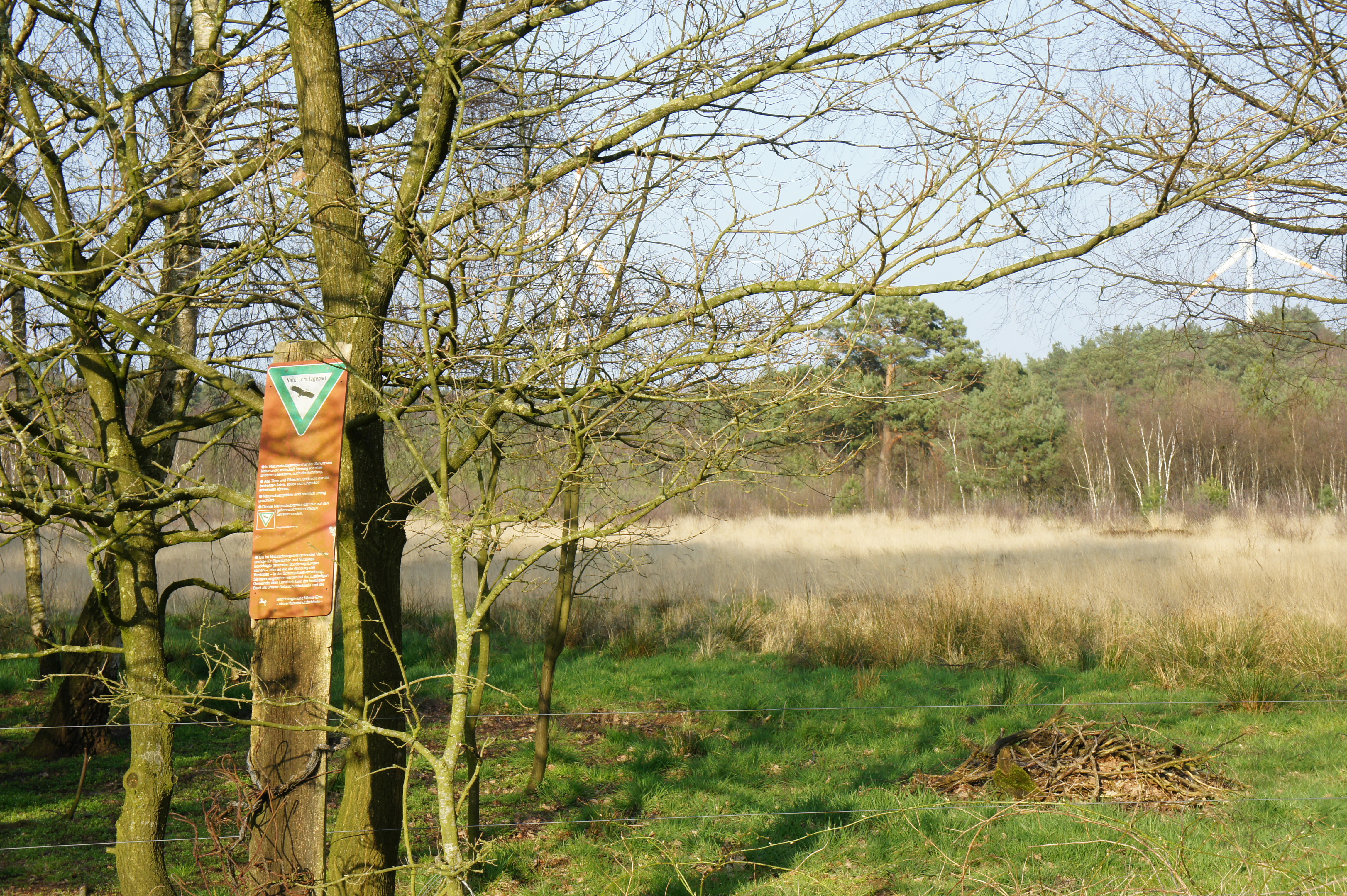
A triangular green and orange nature reserve sign attached to a tree trunk at the edge of a moor landscape with bare trees and grasses.
A nature reserve boundary sign at the edge of the Wunderburger Moor.

Wunderburger Moor history and protected-area timeline

Wunderburger Moor was formally protected as a Naturschutzgebiet, or nature reserve, through an ordinance issued on 9 June 1967, under the identifier NSG WE 126. The designation recognized the area's value as a well-developed small bog at a time when many similar peatland fragments in northwestern Germany were being lost to drainage, peat cutting, and agricultural conversion.

Administrative responsibility for the reserve was assigned to the Landkreis Oldenburg, acting as the lower nature protection authority. Over time, broader oversight has been provided by the Niedersächsischer Landesbetrieb für Wasserwirtschaft, Küsten- und Naturschutz (NLWKN), which manages the official nature reserve database in Lower Saxony. Since its establishment, the reserve has remained a small but stable sanctuary for peatland habitats in the Harpstedt area, with access restricted to marked paths in order to limit disturbance to its sensitive surfaces.

Wunderburger Moor landscape and geographic character

The landscape of Wunderburger Moor is shaped by its position on the gently undulating northwestern German plain. The reserve lies at elevations between approximately 42 and 56 meters above sea level, with a subtle topography that reflects the long history of peat formation and water movement across the site. There are no dramatic landforms; instead, the terrain is a quiet mosaic of low hummocks, shallow depressions, and wet flats typical of small lowland bogs.

Within this modest relief, visitors encounter a finely textured pattern of mire features. Open water surfaces appear in the wettest areas; slightly higher peat surfaces support drier, heathy vegetation; reedbeds line transitions between water and land; and patches of birch woodland occupy the better-drained or more elevated peat. The result is a small-scale landscape where the eye can take in essentially the full range of bog-related scenery within a short walk, framed by the broader agricultural countryside of the Harpstedt region.

Wunderburger Moor ecosystems, habitats, and plant life

The ecological character of Wunderburger Moor centers on its well-developed Kleinmoor, a small bog complex that illustrates several stages of peatland development in one place. The reserve's vegetation forms a layered mosaic, moving from open water through reedbeds and sedge-dominated transition mires to drier peat surfaces clothed in moor heath and, in places, to birch carr woodland.

Open water areas create the foundation of the bog system, supporting aquatic and semi-aquatic vegetation typical of nutrient-poor peat pools. Reedbeds spread along the margins of these water bodies, while sedge-rich Zwischenmoor, or transition mire, occupies the intermediate zones between open water and drier peat. Above these wet areas, moor heath vegetation thrives on more elevated, occasionally ombrotrophic peat, and clumps of birch grow on the better-drained sections, forming small areas of Bruchwald, or wet woodland. This internal diversity is what gives the reserve its particular ecological value, even within its modest footprint of about 34 hectares.

Because the surrounding region is heavily used for agriculture, the reserve plays an important role as a refugium for bog-associated plant communities that have become scarce in the wider landscape. Maintaining the natural water regime of the moor is central to preserving these communities, and the site's protected status helps shield it from the drainage and land-use changes that have affected peatlands elsewhere in northwestern Germany.

Wunderburger Moor wildlife and species highlights

Wunderburger Moor's wildlife is closely tied to its mosaic of bog habitats. The combination of open water, reedbed, sedge mire, and birch woodland provides shelter and feeding grounds for animal species adapted to wet, nutrient-poor environments. Birds typically associated with reedbeds and peatland pools are among the most characteristic inhabitants, along with invertebrates that depend on the specialized peatland vegetation.

The wet woodland and heath sections add further variety, supporting woodland and edge-of-habitat species that benefit from the structural diversity created by scattered birch stands next to open peat. Because the reserve is small and access is restricted to marked paths, wildlife can rely on relatively undisturbed conditions across the bog mosaic, with the surrounding agricultural land framing but not penetrating the protected core.

In ecological terms, the site's value lies less in hosting rare individual species than in maintaining the habitat conditions that allow specialist peatland fauna to persist in an intensively used region. Sustaining water levels, peat-forming vegetation, and the natural openness of the bog surface is essential to keeping this wildlife character intact.

Wunderburger Moor conservation status and protection priorities

Wunderburger Moor holds clear conservation value as a surviving example of a well-developed small bog in a region where peatlands have been extensively altered by drainage, peat extraction, and agricultural land use. By protecting about 34 hectares of mire habitat, the reserve helps preserve bog-forming vegetation, the underlying peat itself, and the hydrological conditions that allow peat to continue accumulating.

At the national level, the reserve is classified as an IUCN Category IV area, a Habitat/Species Management Area, reflecting its focus on maintaining specific habitats and the species associated with them. It is registered in the World Database on Protected Areas under WDPA-ID 82947, and it carries the German nature reserve identifier NSG WE 126. Day-to-day responsibility lies with the Landkreis Oldenburg as the lower nature protection authority, while the Niedersächsischer Landesbetrieb für Wasserwirtschaft, Küsten- und Naturschutz (NLWKN) provides overarching technical and administrative oversight.

A central conservation measure at the site is the strict access rule: visitors may enter only along marked paths. This minimizes trampling damage to fragile peat surfaces and reduces disturbance to sensitive vegetation and wildlife. Combined with its protected legal status and its position as one of the better-developed Kleinmoore in the area, Wunderburger Moor forms an important local anchor for peatland conservation in northwestern Lower Saxony.

Top sights and standout views in Wunderburger Moor

The highlights of Wunderburger Moor center on its compact but complete Kleinmoor landscape, in which a visitor can move from open water through reedbed and sedge mire into birch wet woodland within a short distance. This unusual density of bog habitat types in such a small protected area is the reserve's signature quality.

Equally notable is the site's role as a long-standing protected area in a heavily agricultural region. Designated in 1967 and managed under strict access rules since then, it offers a stable example of how a small peatland sanctuary can survive in an intensively used lowland landscape, and why such modest reserves matter for the broader conservation of northwestern German peatlands.

Best time to visit Wunderburger Moor

The reserve can be visited year-round, but peatland sites like Wunderburger Moor tend to be most rewarding when the weather is mild and the ground is reasonably firm. Late spring and early summer highlight fresh reed and sedge growth, while summer brings the fullest expression of the bog mosaic, with open water, reedbeds, and birch foliage all in leaf.

In cooler or wetter seasons, mists rising from open bog pools can give the landscape an especially atmospheric character, and winter visits, when birch stands are bare and peat surfaces are clearly visible, emphasize the structural diversity of the habitat. Because access is restricted to marked paths at all times of year, comfortable walking shoes, weather-appropriate clothing, and an appreciation for quiet, careful observation are more relevant than any particular calendar window.


Monthly climate preview

Long-term representative measurements showing monthly temperature swings and precipitation patterns

Wunderburger Moor Climate Normals, Annual Temperature and Precipitation Profiles

Representative coordinate records outline the measured annual temperature and precipitation rhythm across Wunderburger Moor from 1991 through 2020. Examining the complete twelve-month climate profile reveals detailed monthly averages for planning conservation context and geographic research.
Annual mean9 °C
1 °C18 °C
Jan
Feb
Mar
Apr
May13°
Jun16°
Jul18°
Aug18°
Sep14°
Oct10°
Nov
Dec
Warmest month
July

18 °C

Coolest month
January

1 °C

Wettest month
July

2.5 mm/day

Driest month
April

1.4 mm/day

Park location guide

Geography guide, regional context, and park location map for Wunderburger Moor

Wunderburger Moor park geography, regions, and map view in Germany

Understand where Wunderburger Moor sits in Germany through a broader geographic reading of the surrounding landscape, nearby location context, and its mapped position within the national park landscape.

How Wunderburger Moor fits into Germany

Germany is a federal republic in Western and Central Europe with a population of over 83 million across sixteen constituent states. It is Europe's largest economy by nominal GDP and a major global exporter and importer. The capital is Berlin, and the country borders Denmark, Poland, Czech Republic, Austria, Switzerland, France, Luxembourg, Belgium, and the Netherlands.

Wider geography shaping Wunderburger Moor in Germany

Germany is located in Western and Central Europe, spanning 357,022 km². It borders Denmark to the north, Poland and the Czech Republic to the east, Austria and Switzerland to the south, and France, Luxembourg, Belgium, and the Netherlands to the west. The country has coastlines on the Baltic Sea and North Sea to the north, with the Alps located in the southern region.

Map view of Wunderburger Moor

Use this park location map to pinpoint Wunderburger Moor in Germany, understand its exact geographic position, and read its mapped placement within the surrounding landscape more clearly.

Pigeon | © OpenStreetMap contributors

Location context for Wunderburger Moor

Lower Saxony

Visual reference for the micro-bog habitats, terrain, and mire vegetation

Wunderburger Moor Photos, Scenery, and Protected Landscape Imagery

Visual documentation captures the fine-scale mosaic of open water, moor heath, and birch woodland shaping this protected lowland peatland. Studying these field photographs reveals the structural diversity of a classic northern German Kleinmoor ecosystem.

A triangular green and orange nature reserve sign attached to a tree trunk at the edge of a moor landscape with bare trees and grasses.

Park atlas

Compare regional protected areas and adjacent lowland mire habitats.

Exploring Other Parks Near Wunderburger Moor and Protected Landscapes

Browse nearby national parks and protected areas to compare regional peatland geography across the surrounding lowland terrain. Continued exploration reveals connected conservation landscapes and similar protected habitats beyond Wunderburger Moor.
Nature reserveOldenburg
About 8.8 km away#1 closest

North

Stühe Nature Reserve: A Detailed Map and Geographic Overview of the Delmenhorster Geest

Protected beech forests and lowland bog ecosystems in Oldenburg

Stühe serves as a significant forest refuge in the Oldenburg district, showcasing a rare intersection of beech, oak, and riparian floodplain forests. This nature reserve, anchored within the wider Delmenhorster Geest landscape, features glacial depressions, kettle-like stillwaters, and preserved bog monuments that document the natural history of the northwest German lowlands.

Area
2.17 km²
Established
2018
Relief
Lowland
Climate
Temperate
Nature reserveLower Saxony
About 17 km away#2 closest

North

Stenumer Holz Nature Reserve: Protected Ancient Woodland Geography in Lower Saxony

A detailed map-based overview of ancient oak and beech forest ecosystems

Stenumer Holz functions as a critical nature reserve within the Oldenburg district, preserving an ancient broadleaf forest mosaic that stretches across 96 hectares of sandy-geest terrain. The area is defined by its diverse structural composition, including moist oak-hornbeam stands, drier Luzula beech ridges, and narrow alluvial corridors that support specialized woodland flora and old-growth ecological features.

Area
0.96 km²
Established
2018
Relief
Lowland
Climate
Temperate
Nature reserveOldenburg
About 19 km away#3 closest

Northwest

Tannersand und Gierenberg Nature Reserve: Inland Dunes and Bog Pool Mapping

Protected sandy geest landscape within the Osenberge near Oldenburg

Tannersand und Gierenberg represents a vital nature reserve featuring an unusual inland dune system and embedded wetland Slatts. The protected area exhibits a dense contrast between coniferous dune ridges and peat-moss-rich swamps. This record details the park boundaries, landscape mosaic, and the specific terrain that classifies it as a significant protected site within Lower Saxony, Germany.

Area
0.35 km²
Established
1938
Nature reserveBremen
About 21 km away#4 closest

Northeast

Ochtumniederung bei Brokhuchting: Wetland Nature Reserve and Floodplain Geography

A core conservation area within the Bremen Niedervieland

This protected area stands as a primary example of large-scale river floodplain restoration in the Bremen region. The landscape includes a dense network of canals, reedbeds, and seasonal flood zones that provide critical shelter for waterfowl and waders. Through careful environmental management, this site integrates natural riverine terrain with the surrounding industrial and urban framework of northwestern Germany, offering a distinct study of managed wetland ecosystems.

Area
3.75 km²
Established
1998
Relief
Lowland
Climate
Temperate
A watercolor painting showing a soft, panoramic view of a flat wetland area with green trees, a solitary tree in the middle, and industrial silos faintly visible in the background.
Nature reserveBremen
About 23 km away#5 closest

Northeast

Hochwasserschutzpolder zwischen Senator-Apelt-Straße und Neustädter Hafen: Bremen Protected Lands

A vital wetland reserve integrating flood management and avian biodiversity in the port district.

Located within the port district of Bremen, the Hochwasserschutzpolder zwischen Senator-Apelt-Straße und Neustädter Hafen is a notable protected area that balances essential flood-control infrastructure with rich ecological functions. The reserve sustains a variety of wetland bird populations across its reed-lined waters and alluvial woodlands, providing a critical haven for wildlife amidst the surrounding industrial and urban development of the Lower Weser region.

Area
0.847 km²
Established
2014
IUCN
IV
Nature reserveBremen
About 26 km away#6 closest

Northeast

Vogelschutzgebiet Arsten-Habenhausen: Mapping the Protected Weser Floodplain Habitat

A historic urban nature reserve located in Bremen

Located in the Habenhausen district of Bremen, Vogelschutzgebiet Arsten-Habenhausen is a significant protected area focused on river floodplain maintenance. The site provides a concentrated view of floodplain woodland and reedbed vegetation, illustrating how small, long-established nature reserves contribute to the regional geography of the Weser river corridor in Germany.

Area
0.01 km²
Established
1950
IUCN
IV
Relief
Lowland
Nature reserveLower Saxony
About 26 km away#7 closest

East

Wachendorfer/Gödestorfer Bruch Nature Reserve and Protected Wetland Landscape in Lower Saxony

Wetland geography and forest conservation in the Diepholz district

Wachendorfer/Gödestorfer Bruch provides a clear view into the transitional wetland ecosystems of Lower Saxony. The nature reserve features a complex of wet woodland and grassland habitats that highlight the hydrological diversity of the Diepholz district, offering significant insight into regional forest conservation and land management.

Area
1.95 km²
Established
2000
IUCN
IV
Relief
Lowland
Nature reserveBremen
About 28 km away#8 closest

North

Dunger See Nature Reserve: Mapped Protected Wetland and Landscape Geography in Bremen

A structured geographic look at the Werderland bird protection habitat.

Dunger See is a compact, ecologically diverse nature reserve in Bremen, shaped by intentional land management to provide critical nesting and wintering grounds for wildfowl. This protected area stands out for its indented shoreline, artificial island clusters, and surrounding woodland buffers that contrast with the open agricultural terrain of the wider Werderland landscape.

Area
0.33 km²
Established
1990
Relief
Lowland
Climate
Temperate

Common questions about visiting, size, designation, and location context for Wunderburger Moor

Wunderburger Moor FAQs for park facts, access, geography, and protected area context

Find quick answers about Wunderburger Moor, including protected-area facts, park geography, trail and visitor context, and how the park fits into its surrounding country and regional landscape.
MoriAtlas Explorer

Continue Your Protected Areas Search Across the Global Atlas

Deepen your exploration by continuing the structured search for national parks and protected areas worldwide. Utilize the comprehensive filtering capabilities to compare different conservation landscapes and refine your understanding of global park geography. Discover more about the distribution and characteristics of protected natural areas.

Global natural geography