

Mori Atlas logo
Nature reserveYatteyattah Nature Reserve

Explore the geographic boundaries and distinct monzonite-based forest terrain of this coastal protected landscape.

Yatteyattah Nature Reserve: Mapping the Southernmost Subtropical Rainforest in New South Wales

Yatteyattah Nature Reserve protects a vital subtropical rainforest remnant on the South Coast of New South Wales, serving as a critical scientific reference site for rainforest ecology at its southern distribution limit. The small, dense forest thrives on mineral-rich monzonite soils, creating a sharp contrast against the surrounding open rural farmland. This protected landscape preserves a mosaic of forest red gum woodlands and moist rainforest gullies, mapping the climatic edge where diverse species reach their natural range boundaries.

subtropical rainforestrainforest remnantcoastal hinterlandprotected foreststrict nature reserveNSW South Coast
An artistic illustration featuring a mountain range with a waterfall flowing into a river through a forested valley, rendered in a flat design, minimalist style.

Yatteyattah Nature Reserve

Nature reserve

Park overview

Structured park overview, official facts, and landscape profile for Yatteyattah Nature Reserve

Yatteyattah Nature Reserve park facts, protected area profile, and essential visitor context

Review the core facts for Yatteyattah Nature Reserve, including designation, size, terrain, visitor scale, habitats, and operating context in one park-focused overview.

About Yatteyattah Nature Reserve

Yatteyattah Nature Reserve is a compact but ecologically rich protected area on the South Coast of New South Wales, protecting a fragment of subtropical rainforest near the locality of Yatte Yattah. Although only about 35 hectares in extent, the reserve punches well above its size in ecological and scientific significance, acting as a living laboratory for rainforest communities approaching their southern climatic limit.

The reserve lies on soils derived from the Milton Monzonite, a distinctive local geology that, combined with a temperate maritime influence from the nearby coast, produces conditions unusually favourable for rainforest growth. Annual rainfall of around 1,200 millimetres, combined with moderate temperatures, allows the reserve to maintain a structurally complex subtropical canopy alongside drier forest communities typical of the broader South Coast landscape.

Ecologically, Yatteyattah's importance lies in its position as a southern outpost for many typically more northerly subtropical species. Red cedar, myrtle ebony, deciduous fig, citronella, silver quandong, whalebone tree, and bollygum all grow here near the edge of their natural range. The reserve also supports a striking epiphytic flora, with birds nest ferns and elkhorn ferns festooning the trunks and branches of older trees, contributing to the rainforest's characteristic lush, layered appearance.

The combination of small size, sharp ecological boundaries, and proximity to cleared agricultural land gives Yatteyattah a clearly defined identity as a protected rainforest island within an otherwise more open landscape. Visitors and researchers encounter an unusually dense and species-rich forest community compressed into a reserve that can be explored in a relatively short visit, yet which reveals considerable botanical complexity on closer examination.

Quick facts and research context for Yatteyattah Nature Reserve

Yatteyattah Nature Reserve is located on the South Coast of New South Wales, close to the town of Milton, and protects roughly 35 hectares of subtropical rainforest and associated forest red gum woodland. It is managed as a strict nature reserve (IUCN Category Ia) by the NSW National Parks and Wildlife Service, and was formally gazetted in April 1996 after being donated by a local farmer.

The reserve sits at an estimated elevation of around 546 metres and receives approximately 1,200 millimetres of rainfall each year. Its underlying geology is dominated by the Milton Monzonite, which has produced the well drained soils that help sustain its forest communities.

Protection and recognition

Terrestrial conservation framework and official protected area records

Yatteyattah Nature Reserve Protection Status and International Recognition

Yatteyattah Nature Reserve maintains documented terrestrial protection status within official conservation inventories. Structured records compile available designation history, management scope, and international recognition details for this protected area.

Protection details

Protection scope
Terrestrial
Park context

Deeper park guide and search-rich context for Yatteyattah Nature Reserve

Yatteyattah Nature Reserve history, landscape, wildlife, and travel context

Explore Yatteyattah Nature Reserve through its history, landscape character, ecosystems, wildlife, conservation priorities, cultural context, and seasonal travel timing in a structured park guide built for atlas discovery and search intent.

Why Yatteyattah Nature Reserve stands out

Yatteyattah is best known for hosting the most southerly significant subtropical rainforest remnant in Australia. The reserve is a scientific reference point for rainforest ecology at the southern climatic edge of the subtropics. It is also notable for the unusually diverse assemblage of rainforest trees and epiphytes that reach their natural distribution limits within the small reserve footprint, including red cedar, myrtle ebony, citronella, silver quandong, whalebone tree, and impressive displays of birds nest and elkhorn ferns.

A dense subtropical rainforest scene with sunlight filtering through the canopy, featuring large bird's nest ferns attached to slanted tree trunks and fallen logs on the forest floor.
Subtropical rainforest interior at Yatteyattah Nature Reserve, highlighting epiphytic bird's nest ferns growing on the trees.

Yatteyattah Nature Reserve history and protected-area timeline

The land that now forms Yatteyattah Nature Reserve was originally part of the broader forested landscape of the South Coast hinterland near Milton. For most of its history the area was privately held, and the forest was gradually surrounded by clearing for agriculture and rural settlement.

In 1964 a broad clearing was cut through the forest for electrical power lines, despite the surrounding country being largely cleared and despite the ecological value of the remaining rainforest block. The episode remains a notable moment in the reserve's history, illustrating the pressures the small forest faced before formal protection.

In the early 1990s a local farmer donated the land to ensure its long term protection. This donation led to the formal establishment of the Yatteyattah Nature Reserve in April 1996, when the area was gazetted as a protected reserve under the management of what is now the NSW National Parks and Wildlife Service. The reserve retains the strict nature reserve status, reflecting its primary purpose of conserving ecological values rather than accommodating large scale recreation.

Yatteyattah Nature Reserve landscape and geographic character

The landscape of Yatteyattah Nature Reserve is defined by modest elevation, locally rugged terrain, and a sharp contrast between sheltered forested slopes and the surrounding cleared countryside. The reserve sits at an estimated elevation of around 546 metres, with topography that creates a mosaic of microclimates within a very small land area.

The underlying Milton Monzonite produces well drained, mineral rich soils that have weathered into gently undulating slopes and small gullies. On the higher, more exposed plateau, these conditions support a drier forest red gum woodland, while sheltered slopes and lower areas retain the moisture necessary to sustain subtropical rainforest.

The broader setting is open rural farmland and grazing country typical of the Milton area on the New South Wales South Coast. From the surrounding clear country, the reserve appears as a sudden pocket of tall, dense forest, with emergent red cedars and a layered canopy that visually marks the transition from the more open regional landscape into closed subtropical rainforest.
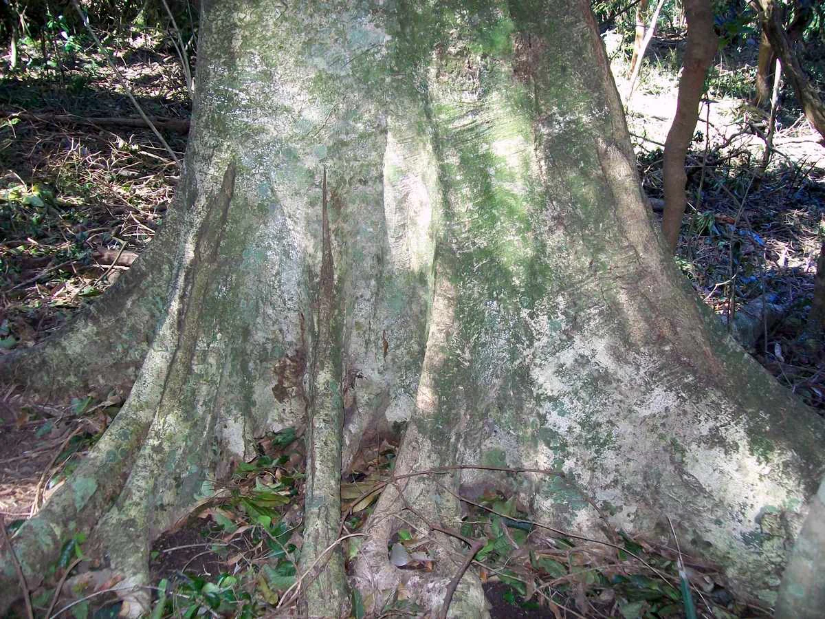
A close up view of the base of a large tree showing prominent, greyish buttress roots growing from the forest floor.
The buttress roots of an Elaeocarpus kirtonii tree within the Yatteyattah Nature Reserve.

Yatteyattah Nature Reserve ecosystems, habitats, and plant life

Yatteyattah Nature Reserve protects two ecologically interlinked forest types occurring within a very small footprint: a moist subtropical rainforest community and a drier forest red gum woodland on the higher plateau. The combination is biologically unusual for such a small reserve and is closely tied to the local monzonite geology, moderate climate, and reliable rainfall.

The rainforest component is of particular scientific interest as the most significant southerly subtropical rainforest remnant in Australia. Several tree species characteristically associated with warmer, wetter environments further north reach the edge of their natural distribution here, including red cedar, myrtle ebony, deciduous fig, citronella, silver quandong, whalebone tree, and bollygum. These species give the canopy its distinctive composition and structural complexity.

An outstanding feature of the reserve's ecology is its abundance of epiphytic ferns. Birds nest ferns and elkhorn ferns grow prominently on larger trees, contributing a lush, layered appearance to the forest and supporting the moist microclimates that rainforest specialists depend on. Together, these elements make the reserve a compact but exceptionally representative example of southernmost Australian subtropical rainforest.
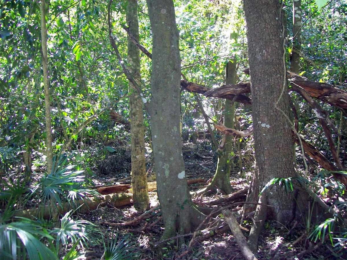
A dense subtropical rainforest interior with tall tree trunks, including one with a visible buttressed base on the right, under a thick green canopy.
Subtropical rainforest interior within Yatteyattah Nature Reserve.

Yatteyattah Nature Reserve wildlife and species highlights

Yatteyattah Nature Reserve is primarily valued for its botanical rather than faunal profile, but the dense rainforest and mature trees provide important habitat for forest dependent wildlife. The layered canopy, fallen logs, and moist microclimates support a range of invertebrates, reptiles, and birds typical of South Coast rainforest remnants.

Large old trees, including emergent red cedars, offer nesting hollows and perching sites for forest birds, while the fern laden trunks and shaded forest floor provide shelter for ground dwelling animals. The reserve's small size means wildlife populations are linked to the surrounding landscape, and its ecological value is enhanced by the contrast it provides against surrounding cleared farmland.
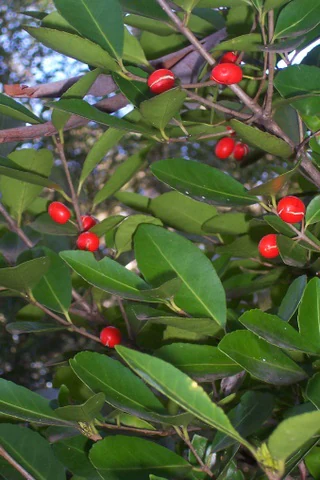
A close-up view of the leaves and bright red berries of an Elaeodendron australe plant.
Red fruit of Elaeodendron australe in Yatteyattah Nature Reserve.

Yatteyattah Nature Reserve conservation status and protection priorities

The conservation significance of Yatteyattah Nature Reserve lies in its role as a protected southern outlier of Australia's subtropical rainforest biome. As a strict nature reserve, its primary objective is ecological preservation rather than recreation, and it is managed by the NSW National Parks and Wildlife Service in that capacity.

The reserve is recognised as the most significant southerly subtropical rainforest remnant in Australia, making it an important reference site for monitoring how rainforest communities respond at the climatic edge of their range. It also preserves populations of several tree species at or near their southern natural distribution limit, including silver quandong and red cedar, giving it value for understanding range dynamics under changing climatic conditions.

By protecting this small block of forest from further clearing and disturbance, the reserve safeguards an unusually complete representation of rainforest ecology compressed into a small area, set apart from the predominantly cleared agricultural landscape that surrounds it.

Yatteyattah Nature Reserve cultural meaning and human context

Yatteyattah's cultural context is shaped primarily by its history as privately held farmland gradually surrounded by agricultural clearing, rather than by distinct Indigenous or heritage features documented in the reserve record. The locality name Yatte Yattah reflects the place naming patterns of the broader South Coast region of New South Wales.

The reserve's establishment reflects a local conservation effort by a farmer who chose to donate the land rather than see it cleared or developed. That act of donation is central to the reserve's modern cultural identity, marking it as a community led conservation initiative within the dairy and grazing landscape of the Milton area.

Top sights and standout views in Yatteyattah Nature Reserve

Yatteyattah Nature Reserve's standout quality is the compression of southernmost Australian subtropical rainforest into a very small protected footprint. Despite covering only about 35 hectares, it supports an unusually rich suite of rainforest tree species and one of the finest displays of epiphytic ferns on the New South Wales South Coast.

Other highlights include its red cedar and silver quandong individuals growing at the natural southern limit of their distribution, the visually striking contrast between the reserve's dense forest and the surrounding cleared farmland, and its role as a quiet scientific reference site for rainforest ecology near the climatic edge of the subtropics.

Best time to visit Yatteyattah Nature Reserve

Yatteyattah Nature Reserve can be visited year round, and its evergreen rainforest means it remains green and structurally intact in all seasons. Rainfall is moderate and well distributed, so conditions underfoot can be damp at any time of year, particularly after rain.

Milder months in autumn, winter and spring tend to be comfortable for exploring the small reserve, when cooler temperatures and reduced humidity make walking easier. Summer days are warmer and can be humid under the dense canopy, but the dense foliage also provides shaded conditions. Because the reserve's attraction is botanical rather than seasonal scenery, there is no single peak season, and visits outside the hottest periods generally offer the most comfortable experience.


Monthly climate preview

Long-term representative temperature and precipitation averages across the annual cycle

Yatteyattah Nature Reserve Climate Normals and Monthly Weather Patterns

Representative coordinate records show measured average temperatures ranging from 13.8 °C to 21.68 °C alongside consistent monthly precipitation rates at Yatteyattah Nature Reserve. Examining the full twelve-month climate profile reveals complete seasonal temperature boundaries and detailed rainfall distribution patterns.
Annual mean18 °C
14 °C22 °C
Jan21°
Feb22°
Mar21°
Apr19°
May17°
Jun15°
Jul14°
Aug14°
Sep15°
Oct17°
Nov18°
Dec20°
Warmest month
February

21.7 °C

Coolest month
July

13.8 °C

Wettest month
February

4.3 mm/day

Driest month
September

2 mm/day

Park location guide

Geography guide, regional context, and park location map for Yatteyattah Nature Reserve

Yatteyattah Nature Reserve park geography, regions, and map view in Australia

Understand where Yatteyattah Nature Reserve sits in Australia through a broader geographic reading of the surrounding landscape, nearby location context, and its mapped position within the national park landscape.

How Yatteyattah Nature Reserve fits into Australia

Australia is a constitutional monarchy and federal parliamentary democracy comprising six states and ten territories. With a population of nearly 28 million, it is one of the world's most urbanised countries, with most people concentrated on the eastern seaboard. The country has a high Human Development Index and is known for its cultural diversity, ancient Aboriginal heritage, and unique wildlife.

Wider geography shaping Yatteyattah Nature Reserve in Australia

Australia occupies the entire Australian continent, the island of Tasmania, and numerous smaller islands. It is the world's flattest and driest inhabited continent, featuring vast deserts in the interior (the Outback), tropical rainforests along the eastern coast, and a coastline bordering the Indian and Pacific Oceans.

Map view of Yatteyattah Nature Reserve

Use this park location map to pinpoint Yatteyattah Nature Reserve in Australia, understand its exact geographic position, and read its mapped placement within the surrounding landscape more clearly.

Pigeon | © OpenStreetMap contributors

Location context for Yatteyattah Nature Reserve

New South Wales

Visual reference of subtropical rainforest habitats and coastal terrain

Yatteyattah Nature Reserve Photos and Protected Landscape Scenery

Visual records capture the dense forest canopy, sheltered gullies, and distinct ecological transition zones defining Yatteyattah Nature Reserve. Photographic documentation provides clear insight into southernmost subtropical rainforest habitats and surrounding regional terrain.

A dense subtropical rainforest scene with sunlight filtering through the canopy, featuring large bird's nest ferns attached to slanted tree trunks and fallen logs on the forest floor.

A low-angle view of tall, smooth-barked Eucalyptus trees reaching toward a clear blue sky, with a dense understory of green shrubs and grasses below.

A close up view of the base of a large tree showing prominent, greyish buttress roots growing from the forest floor.

A dense subtropical rainforest interior with tall tree trunks, including one with a visible buttressed base on the right, under a thick green canopy.

A close-up view of the leaves and bright red berries of an Elaeodendron australe plant.

Park atlas

Compare regional coastal reserves and nearby protected habitats across the New South Wales South Coast

Exploring Other Parks Near Yatteyattah Nature Reserve and Surrounding Protected Landscapes

Browse other protected areas near Yatteyattah Nature Reserve to examine connected coastal rainforests and regional forest habitats. Such comparisons reveal how isolated botanical reserves fit into broader patterns of Australian plant distribution.
National parkNew South Wales
About 1.6 km away#1 closest

East

Conjola National Park: Mapped Protected Landscape within New South Wales Geography

Explore the park's protected boundaries and regional terrain.

Conjola National Park represents a distinct protected landscape within New South Wales, offering rich opportunities for geographic discovery. As a national park, its mapped boundaries and natural terrain contribute significantly to the regional atlas. This entry provides essential context for understanding the park's protected identity and its contribution to the broader geographic landscape of Australia, facilitating detailed map exploration.

Area
10 km²
Established
1994
IUCN
II
Relief
Lowland
Watercolor landscape illustration showing green fields, trees, hills, and pastel sky
National parkNew South Wales
About 4.2 km away#2 closest

Northwest

Morton National Park: A Protected Landscape of Waterfalls and Dissected Plateaus in New South Wales

Explore its mapped boundaries and regional geographic context.

Morton National Park is a nationally recognized protected area within New South Wales, Australia, celebrated for its striking natural features and geographic significance. The park's landscape is characterized by a dramatic dissected plateau, giving rise to impressive waterfall systems such as Fitzroy Falls and Belmore Falls that cascade into deep gorges. As a key component of the Southern Highlands' natural heritage, Morton National Park provides a rich subject for atlas exploration, offering insights into regional terrain, protected land distribution, and the unique interplay of natural elements within this Australian national park.

Area
1,997.45 km²
Established
1967
IUCN
II
Relief
Mixed relief
National parkNew South Wales
About 13 km away#3 closest

South

Meroo National Park: Protected National Park in New South Wales with Mapped Landscape Identity

Explore the protected landscape and geographic context of this national park.

Meroo National Park is a protected national park located in New South Wales, Australia, offering specific geographic context for atlas exploration. This page provides details on its mapped boundaries and its identity as a conservation landscape. Understanding Meroo National Park's place within the regional geography of New South Wales is key to appreciating its protected status and unique natural characteristics, all within a framework designed for structured geographic discovery.

Established
2001
IUCN
II
Relief
Lowland
Climate
Temperate
National parkNew South Wales
About 15 km away#4 closest

North

Jerrawangala National Park: Protected Landscape Identity and New South Wales Geographic Context

Explore its mapped terrain and regional protected area distribution.

Jerrawangala National Park stands as a distinct protected natural area within the geography of New South Wales. This resource details its protected landscape character and its position within the broader regional atlas. Users can understand the park's mapped boundaries and its role in conservation landscapes, offering a concrete geographic anchor for exploration. Dive into the specifics of this national park's setting and its contribution to understanding the natural terrain of Australia.

Relief
Upland
Climate
Temperate
Access
Remote access
Scope
Terrestrial
National parkJervis Bay Territory
About 18 km away#5 closest

Northeast

Booderee National Park and Botanic Gardens: Australia's Protected Landscape Atlas Entry

Mapped geographic context within Jervis Bay Territory's national park.

Booderee National Park and Botanic Gardens is a key protected area in Australia, situated within the Jervis Bay Territory. This national park serves as a vital component of the region's geography, providing a clearly mapped landscape for atlas exploration. Understanding its specific protected-area boundaries and the surrounding natural terrain context is essential for a comprehensive geographic overview of this Australian conservation landscape.

Area
63.12 km²
Established
1992
IUCN
II
Relief
Lowland
National parkNew South Wales
About 21 km away#6 closest

Southwest

Budawang National Park: Wilderness Area and Rugged Terrain Map

Discover New South Wales protected landscape geography.

Budawang National Park is recognized for its exceptional wilderness character, defined by the steep topography of the southern Budawang Range. This protected national park features extensive cool temperate rainforests clothing its middle and upper slopes, creating a visually striking and ecologically rich mountain environment. Its rugged terrain, with deep valleys and rocky outcrops, distinguishes it as a remote natural landscape within New South Wales, offering unique habitat pockets and contributing to the region's protected area atlas.

Area
237 km²
Established
1977
IUCN
Ib
Relief
Mountain
National parkNew South Wales
About 27 km away#7 closest

Northeast

Jervis Bay National Park: National Park Protected Landscape and Geographic Context

Explore New South Wales's protected natural terrain and mapped boundaries.

Jervis Bay National Park represents a distinct protected landscape within New South Wales, offering rich opportunities for geographic discovery. This entry details the park's specific location, its mapped natural terrain, and its significance as a protected national park. Understand its role in the regional geography and explore its boundaries through structured atlas information, providing a clear view of its environmental context.

Area
48.57 km²
Established
1995
IUCN
II
Relief
Lowland
National parkNew South Wales
About 28 km away#8 closest

South

Murramarang National Park: Discover Its Mapped Protected Area and New South Wales Geography

Explore the unique landscape and geographic features.

Murramarang National Park stands as a distinct protected area within New South Wales, offering a unique landscape to explore through its mapped boundaries and regional geographic context. This resource provides essential details for understanding its place in the atlas of Australian protected lands. Users can gain a factual appreciation of the park's physical geography and its identity as a national park, grounded in spatial data and mapped terrain.

Area
121 km²
Established
1973
IUCN
II
Relief
Mountain

Common questions about visiting, size, designation, and location context for Yatteyattah Nature Reserve

Yatteyattah Nature Reserve FAQs for park facts, access, geography, and protected area context

Find quick answers about Yatteyattah Nature Reserve, including protected-area facts, park geography, trail and visitor context, and how the park fits into its surrounding country and regional landscape.
MoriAtlas Explorer

Continue Your Protected Areas Search Across the Global Atlas

Deepen your exploration by continuing the structured search for national parks and protected areas worldwide. Utilize the comprehensive filtering capabilities to compare different conservation landscapes and refine your understanding of global park geography. Discover more about the distribution and characteristics of protected natural areas.

Global natural geography